
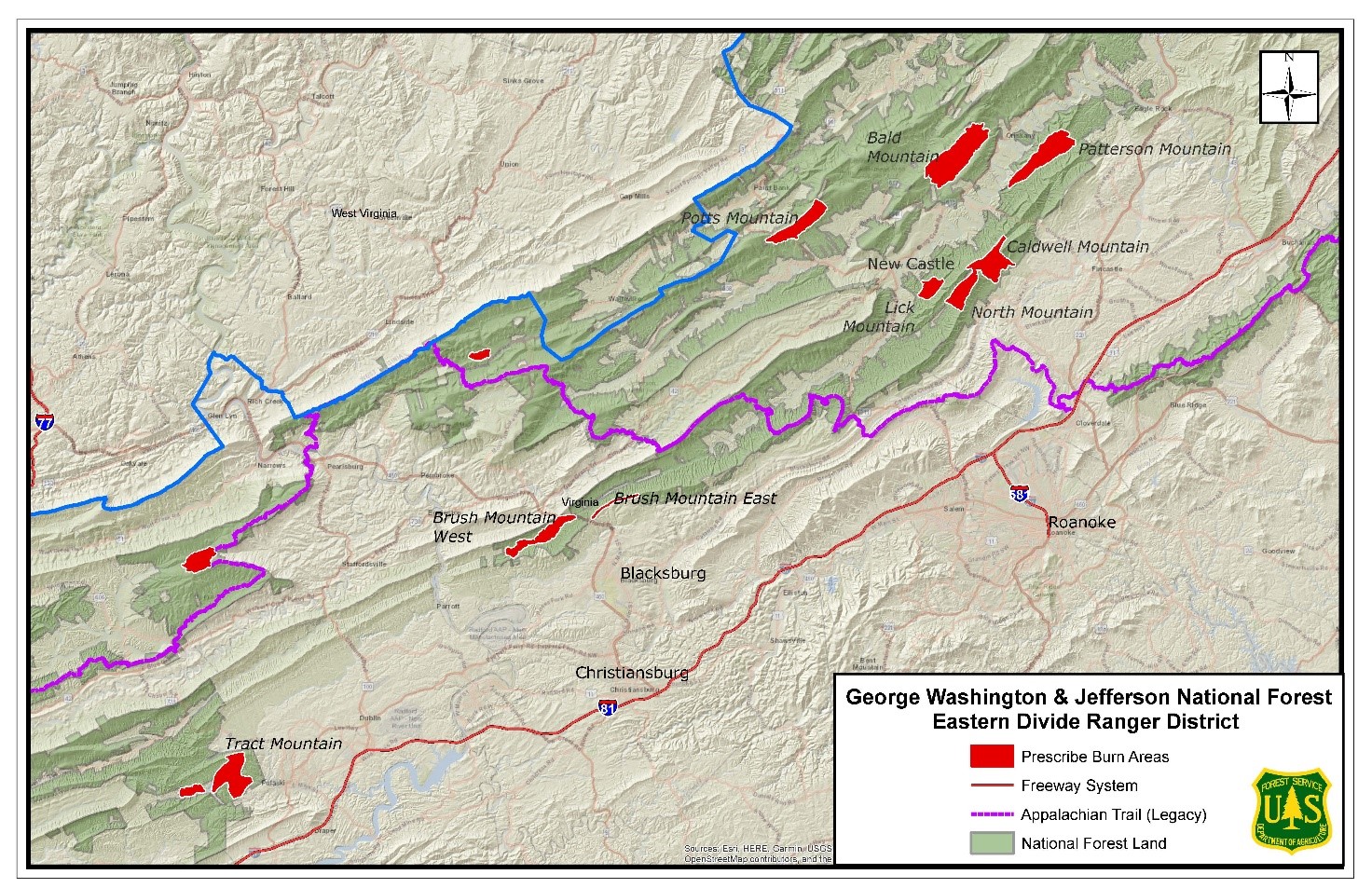
Prescribed Burn in the Tract Mountain Area Pulaski County
Related Incident:
Publication Type: News
Location: This 468-acre burn will take place in the Tract Mountain area, located northwest of Pulaski, Va. and east of Pondlick Road and Gatewood Reservoir.
Date and Time: The Forest Service plans to begin ignitions on April 3, 2021, if weather conditions are appropriate. This prescribed burn will be completed over one to two days. Firefighters will continue to monitor the area for several days after the burn.
Objectives: Prescribed burns keep the public and homes safe by reducing the buildup of dried leaves and wood in nearby forest land that can lead to uncontrolled wildfires. They also create a mosaic of different aged trees and shrubs to improve wildlife habitat.
Additional Information: Depending on wind direction, residents and travelers around the town of Pulaski and along Interstate 81 may smell and see smoke.For more information on our prescribed burn program, please contact the Eastern Divide Ranger District Office at (540) 552-4641, or follow us on twitter: https://twitter.com/GWJNF1.
A map of prescribed burning units located on the Eastern Divide Ranger District is linked below.
Final Update Elk Fire April 7 2021
Related Incident:
Publication Type: News
Location: East Elk Mountain, 30 miles east of Reserve, Catron County, NM on the Gila National Forest.
Start Date: March 31, 2021 Size: ~229 acres Cause: Lightning
Vegetation: Piñon/juniper and grass
Resources: One (1) Type 1 Initial Attack (IA) crew
Summary: The Elk Fire is 229 acres and 100% contained. Incident command has transitioned to the Jackson IHC, with Darren Smith as ICT4 and Karel Williams as ICT4-trainee. All resources except for the Jackson, MS Type 1 IA crew will be released today. During monitoring and reconnaissance today, crews found evidence of a lightning strike which is the cause of this fire.
Smoke from fire rises up and away during the daytime, but in the evenings, smoke can pool back down in canyons, drainages, and basins. For information on air quality and protecting your health, and to find guidance on distances and visibility, please visit https://nmtracking.org/fire. Fire information can be found at https://inciweb.nwcg.gov/incident/7359/.
For information on the Gila National Forest, check out our website at https://www.fs.usda.gov/gila or join the conversation on Facebook and Twitter.
Elk Fire Update April 6 2021
Related Incident:
Publication Type: News
Location: East Elk Mountain, 30 miles east of Reserve, Catron County, NM on the Gila National Forest.
Start Date: March 31, 2021 Size: ~229 acres Cause: Under investigation
Vegetation: Piñon/juniper and grass
Resources: One (1) Type 1 Initial Attack (IA) crew, two (2) Type 2 IA Crews, one (1) handcrew, one (1) Type 6 engines, one (1) Type 3 helicopter, and two (2) Type 2 dozers.
Summary: The Elk Fire is 229 acres. Fire activity is minimal with some interior smoke from burning stumps and heavy fuels. Crews are mopping up and securing lines. The strategy of the fire is full suppression, with confine and containment using natural geographic features and forest roads.
Safety: There is a RED FLAG Warning for the entire Gila National Forest for today, April 6, 2021 from 1200 noon – 8:00 p.m.
Smoke from fire rises up and away during the daytime, but in the evenings, smoke can pool back down in canyons, drainages, and basins. For information on air quality and protecting your health, and to find guidance on distances and visibility, please visit https://nmtracking.org/fire. Fire information can be found at https://inciweb.nwcg.gov/incident/7359/.
For information on the Gila National Forest, check out our website at https://www.fs.usda.gov/gila or join the conversation on Facebook and Twitter.
Elk Fire Update April 5 2021
Related Incident:
Publication Type: News
Location: East Elk Mountain, 30 miles east of Reserve, Catron County, NM on the Gila National Forest.
Start Date: March 31, 2021 Size: ~225 acres Cause: Under investigation
Vegetation: Piñon/juniper and grass
Resources: One (1) Type 1 Initial Attack (IA) crew, two (2) Type 1 IA Crews, one (1) handcrew, one (1) Type 6 engines, one (1) Type 3 helicopter, and two (2) Type 2 dozers.
Summary: The Elk Fire is 225 acres. Resources worked on hot spotting and checking the fire edge on Friday. Crews are mopping up and securing lines. The strategy of the fire is full suppression, with confine and containment using natural geographic features and forest roads.
Smoke from fire rises up and away during the daytime, but in the evenings, smoke can pool back down in canyons, drainages, and basins. For information on air quality and protecting your health, and to find guidance on distances and visibility, please visit https://nmtracking.org/fire. Fire information can be found at https://inciweb.nwcg.gov/incident/7359/.
For information on the Gila National Forest, check out our website at https://www.fs.usda.gov/gila or join the conversation on Facebook and Twitter.
Elk Fire Update for April 4 2021
Related Incident:
Publication Type: News
Location: East Elk Mountain, 30 miles east of Reserve, Catron County, NM on the Gila National Forest.
Start Date: March 31, 2021 Size: ~200 acres Cause: Under investigation
Vegetation: Piñon/juniper and grass
Resources: One (1) Type 1 Initial Attack (IA) crew, two (2) Type 1 IA Crews, one (1) handcrew, one (1) Type 6 engines, one (1) Type 3 helicopter, two (2) Type 2 dozers and one (1) road grader.
Summary: The Elk Fire continues to remain at 200 acres. Resources worked on hot spotting and checking the fire edge on Friday. Heavy equipment which includes two dozers and a grader, have been improving access with one dozer on the Horse Camp Canyon road (FR533) from the junction of FR 30 to the south towards Forest Road 141 with a Type 6 engine, the second dozer is improving access on FR 141 from the junction of County Road CO21/State Route 59 west up FR 141 (Houghton Canyon) towards the Horse Camp Canyon Road. The road grader is improving FR 30 from Drop Point 30 east to Turkey Track. The strategy of the fire is full suppression, with confine and containment using natural geographic features and forest roads.
Smoke from fire rises up and away during the daytime, but in the evenings, smoke can pool back down in canyons, drainages, and basins. For information on air quality and protecting your health, and to find guidance on distances and visibility, please visit https://nmtracking.org/fire. Fire information can be found at https://inciweb.nwcg.gov/incident/7359/.
For information on the Gila National Forest, check out our website at https://www.fs.usda.gov/gila or join the conversation on Facebook and Twitter.
Elk Fire Update April 3 2021 Reserve Ranger District
Related Incident:
Publication Type: News
Location: East Elk Mountain, 30 miles east of Reserve, Catron County, NM on the Gila National Forest.
Start Date: March 31, 2021 Size: ~200 acres Cause: Under investigation
Vegetation: Piñon/juniper and grass
Resources: One (1) Type 1 Initial Attack (IA) crew, two (2) Type 1 IA Crews, one (1) handcrew, two (2) Type 6 engines, one (1) Type 3 helicopter, two (2) Type 2 dozers and one (1) road grader.
Summary: The Elk Fire is primarily active along the ridgelines on the west and southwest perimeter of the fire. Fire behavior has been low-to-moderate during Friday’s cloud cover. Heavy equipment, two dozers and a grader, began improving access with one dozer on the Horse Camp Canyon road (FR533) from the junction of FR 30 to the south towards Forest Road 141 with a Type 6 engine, the second dozer is improving access on FR 141 from the junction of County Road CO21/State Route 59 west up FR 141 (Houghton Canyon) towards the Horse Camp Canyon Road. The road grader is improving FR 30 from Drop Point 30 east to Turkey Track. The strategy of the fire is full suppression, with confine and containment using natural geographic features and forest roads.
Smoke from fire rises up and away during the daytime, but in the evenings, smoke can pool back down in canyons, drainages, and basins. For information on air quality and protecting your health, and to find guidance on distances and visibility, please visit https://nmtracking.org/fire. Fire information can be found at https://inciweb.nwcg.gov/incident/7359/.
For information on the Gila National Forest, check out our website at https://www.fs.usda.gov/gila or join the conversation on Facebook and Twitter.
Elk Fire Reserve Ranger District
Related Incident:
Publication Type: News
Location: East Elk Mountain, 30 miles east of Reserve, Catron County, NM on the Gila National Forest.
Start Date: March 31, 2021 Size: ~151 acres Cause: Lightning
Vegetation: Piñon/juniper and grass
Resources: FS crew, on order two (2) Type 1 Initial Attack Crews, two (2) Type 6 engines, a Type 3 helicopter.
Summary: The Elk Fire is primarily active on the southern perimeter of the fire. There has minimal fire activity in the piñon/juniper, and the northern perimeter is currently checked up due to patchy snow. Aerial reconnaissance of the fire shows it to be approximately 151 acres. The strategy of the fire is full suppression, with confine and containment using natural geographic features and forest roads.
Smoke from fire rises up and away during the daytime, but in the evenings, smoke can pool back down in canyons, drainages, and basins. For information on air quality and protecting your health, and to find guidance on distances and visibility, please visit https://nmtracking.org/fire. Fire information can be found at https://inciweb.nwcg.gov/incident/7359/.
For information on the Gila National Forest, check out our website at https://www.fs.usda.gov/gila or join the conversation on Facebook and Twitter.
Tecolote Fire Final Update April 10 230PM
Related Incident:
Publication Type: News
Tecolote Fire Final Update: April 10, 1430 hours
Location: Hidalgo County, west of Raymondville and north of Hwy 186
Acreage: 818.7 acres
Containment: 100%
Cause: Lightning
The Tecolote Fire is now 100% contained.
Tecolote Fire Update April 8 900AM
Related Incident:
Publication Type: News
Tecolote Fire Update: April 8, 0900 hours
Location: Hidalgo County, west of Raymondville and north of Hwy 186
Acreage: 818.7 acres
Containment: 95%
Cause: Lightning
Local resources have reported the fire is mapped at 818.7 acres and 95% contained.
Tecolote Fire Update April 3 900AM
Related Incident:
Publication Type: News
Tecolote Fire Update: April 3, 0900 hours
Location: Hidalgo County, west of Raymondville and north of Hwy 186
Acreage: 845 acres
Containment: 80%
Cause: Lightning
Crews made good progress yesterday working hot spots and areas of concern along the perimeter of the fire. Containment will hold at 80%. The fire has been transferred to local resources that will continue to work and monitor the fire.