
Morning Post with Photo Thursday April 1 2021
Related Incident:
Publication Type: News
The scattered smoke you see in this photo represents hot spots that could rekindle in the dry, windy conditions we expect today. Last night, firefighters worked to extinguish any hot spots near structures, as they repeatedly checked on those properties.The fire area is under a Red Flag Warning through this evening, due to historically dry fuels, wind, and low humidity. Our firefighters need your help today: Please avoid outdoor use of fire, or anything that could make sparks. Together, we can prevent another new fire.#SchroederFire2021

Road Closures and Evacuations
Related Incident:
Publication Type: Closures
Updated All evacuations and closures for the Schroeder Fire have been lifted. Some areas are only open to residents. Please check the Pennington County Sheriff's page for more information.
Road Closures and Evacuations are in Place
For all road closure and evacuations please visit https://www.pennco.org/SchroederfRoadFire or https://www.facebook.com/rapidcitypenningtoncountyemergencymanagement/
Donation Announcement
Related Incident:
Publication Type: Announcement
We've had so many generous offers for donations to support firefighters. We truly appreciate the offers however, firefighters are fully supported by our logistics section to include water, electrolyte drinks, food, Nomex (fire protective clothing), sleeping bags, medical supplies, and firefighting equipment. One option to support firefighters across South Dakota is to reach out to your local volunteer fire department. Often they are in need of funding, supplies, and volunteers!
Schroeder Fire Update Monday March 29 2021
Related Incident:
Publication Type: News
Monday, March 29, 2021
· Located 4 miles west of Rapid City off Schroeder Road which is off of Nemo Road in Pennington County
· Local, State, and Federal resources have responded
· This is a dynamic wind driven fire - estimated size is not available at this time
· A fire investigator has been ordered to determine cause
· Evacuations are currently taking place
UPDATE at 4:30 pm following Press Conference:
* Estimated at 800 acres
* MMA flight was ordered from Colorado to fly the fire tonight and get a more accurate size
* Infrastructure - power lines were damaged
* A structure assessment team has been ordered
* Three heavy airtankers were ordered and will report to the Tanker Base
* An air attack platform was ordered
* Winds have decreased, and a National Guard helicopter has been in use
Official Schroeder Facebook page link: https://www.facebook.com/SchroederFire2021/
Inciweb: https://inciweb.nwcg.gov/incident/7356/Schroeder Fire Update
Related Incident:
Publication Type: News
Fire start date: 3/29/2021
Fire size today: 2,165 acres
Containment: 47%
Location: One mile west of Rapid City, SD
Personnel: 250
Cause: Under investigation
Management:
Rocky Mountain Type 2 Blue Team
Air Operations:
2 Air Attack fixed wing
1 Heavy Air Tanker available
2 Black Hawk helicopters available
1 Type 3 helicopter
Evacuation Information:
The Pennington County Sheriff’s Office: 605.394.2174
https://www.pennco.org/SchroederfRoadFire
Command of the Schroeder Fire transitioned to the Rocky Mountain Incident Management Blue Team at 6:00 p.m. yesterday.
Red Flag warnings are in effect due to dry, windy conditions with the weather forecast calling for highs in the 50s today and winds gusting from 20 to 30 mph this afternoon. Similar, though slightly less windy conditions are expected on Thursday.
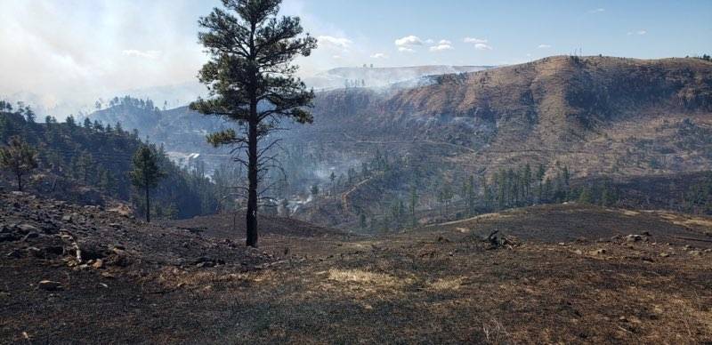
The Schroeder Fire has grown to 2,165 acres and is 47% contained.
Yesterday, crews were able to construct containment lines along the west and east ends of the fire. Heavy air tankers dropped retardant along the fire’s southern edge, in the Cleghorn Canyon area. Today, firefighters will continue to focus on protecting structures throughout the fire area and constructing and improving firelines on the northern and southern edges of the fire perimeter. Air support is available if it is needed. Overnight crews will continue to patrol and monitor fire activity around structures and private property.
The fire is producing light smoke that is visible from Rapid City, which settles into the valley overnight. This air inversion is expected to lift by mid-day.
Evacuations are in place. Please visit https://www.pennco.org/SchroederfRoadFire or https://www.facebook.com/rapidcitypenningtoncountyemergencymanagement/
for updated evacuation information and maps.
Incident Information: https://inciweb.nwcg.gov/incident/7356/
Facebook: https://www.facebook.com/SchroederFire2021
Fire Information – Phone: 605.923.8345 Email: 2021schroederfire@gmail.com
Call Center Hours of Operation: 7 a.m. – 7 p.m.
Mount Rushmore National Memorial will reopen for visitors 500 am 4121
Related Incident:
Publication Type: News
Mount Rushmore National Memorial News Release
For Immediate Release
Release Date: March 31, 2021
Contact: Maureen McGee-Ballinger, maureen_mcgee-ballinger@nps.gov, 605-574-3115
Ready for Visitors
KEYSTONE, S.D. – Mount Rushmore National Memorial will reopen for visitors 5:00 a.m. Thursday morning April 1. State Road 244 east and west entrances will reopen at midnight tonight. Iron Mountain road will remain closed through tomorrow allowing firefighters to continue mop-up operations.
“Fire response in the Black Hills relies on the interagency collaboration and the coordination of Resources by the Great Plains Interagency Dispatch Center in Rapid City,” stated Superintendent Wheatley. “We are grateful to the multiple agencies and firefighters that provided a swift response enabling the reopening of the park. I would like to thank the Incident Commanders Joh Stahl, Matt Spring, Eric Allen, and Brandon Sanchez, for their leadership during this incident and United States Forest Service Agency Administrator Tracy Anderson for her support.”
Responders included firefighters from Black Hills National Forest, Tatanka Hotshots, Custer, Hill City, Lead, Rapid City, Rapid Valley, Spearfish, Pennington County Sheriff’s Office, South Dakota Highway Patrol, South Dakota State Wildland Fire, South Dakota National Guard, Campbell County Wyoming, United States Forest Service, Bureau of Land Management, and National Park Service.
Media with questions about the fire, please contact Fire PIO Travis Mason-Bushman at 605-228-3867. For media updates concerning the park opening, please contact Maureen McGee-Ballinger at 605-574-3115.
For information, please visit Mount Rushmore National Memorial’s official website at www.nps.gov/moru
www.nps.gov
About the National Park Service. More than 20,000 National Park Service employees care for the 419 national parks in the National Park System and work with communities across the nation to help preserve local history and create close-to-home recreational opportunities. Visit us at www.nps.gov, on Facebook www.facebook.com/nationalparkservice, Twitter www.twitter.com/natlparkservice, and YouTube www.youtube.com/nationalparkservice
Glass Canyon Fire Final Update
Related Incident:
Publication Type: News
Glass Canyon Fire Update: March 28, 1800 hours
Location: approximately 6 miles south of Sanderson, Terrell County
Acreage: 92 acres
Containment: 100%
Decrease in acreage is due to more accurate mapping. The majority of the fire area was inactive today but contained some pockets of heat that ground crews were able to cool down.
All Texas A&M Forest Service personnel have been released and control has been turned back over to the local fire department to monitor.
Glass Canyon Fire Update March 28 1100AM
Related Incident:
Publication Type: News
Glass Canyon Fire Update: March 28, 1100 hours
Location: approximately 6 miles south of Sanderson, Terrell County
Acreage: estimated 425 acres
Containment: 15%
Fire behavior is currently low. The Lone Star State Handcrew Module has joined the personnel list of resources assisting on the Glass Canyon Fire. Crews are making slow progress due to terrain. Aerial resources have been requested and will be assisting ground crews with fire suppression efforts.
Current Texas A&M Forest Service resources are 24 personnel, 1 bull dozer, 7 trucks, and 1 air attack.
Weather: Morning satellite imagery shows a few lingering high clouds over the fire site which will begin clearing shortly. 20 foot winds will remain out of the northeast this morning and gradually shift around to the east by the afternoon. Wind speeds are expected to remain at or below 15mph. Minimum humidity values will fall to 10% this afternoon and around 12% Monday afternoon. Overnight moisture recovery will be fair.
Update Thursday April 8
Related Incident:
Publication Type: Announcement
Fire staff are on site at the Ramshorn Prescribed Burn area today patrolling control lines and mopping up, as needed.
Update Wednesday April 7
Related Incident:
Publication Type: Announcement
Firefighters returned to the Ramshorn Prescribed Burn area this morning to clean up unburned patches within the 1,005 burn area. Visitors and residents may see or smell smoke as these smaller areas are burned.