
April 17 West Fork Prescribed Burn
Related Incident:
Publication Type: Announcement
Weather permitting, firefighters on the West Fork District will conduct underburning operations by hand on up to 120 acres on the Frazier Interface located south of Pierce Creek and north of Baker Creek. Underburning, a type of prescribed fire treatment, ignites surface fuels under the forest canopy. Without low-intensity fire on the landscape, our fire-adapted natural areas are less healthy and are more susceptible to drought, insects, disease, and an increased risk of high severity wildfires.
Ignitions are scheduled to start around 11 am. Smoke may be visible from the West Fork Road.
Interactive Map

April 16 Larry Bass Update
Related Incident:
Publication Type: Announcement
Firefighters have completed 200 acres on the Larry Bass Prescribed Burn. Ignitions will be complete later this afternoon. The broadcast burn will help reduce the risk of high severity wildfire, improve overall forest healthy, and protect many of the areas large and distinctive ponderosa pine trees.
To provide for visitor safety, the area remains closed to the public. Visit InciWeb for closure details and map: https://inciweb.nwcg.gov/incident/article/7351/59148/.
April 16 Trapper Bunkhouse Prescribed Fire
Related Incident:
Publication Type: Announcement
Heads up, smoke will likely be visible today from a prescribed burn in the Bitterroot Mountains, south west of Darby between Little Tin Cup & McCoy Creeks. Firefighters plan to hand ignite 90 acres of the Trapper Bunkhouse Unit #11. The prescribed burn will reduce residual slash from a recent thinning and timber harvest operation. Other benefits include improving wildlife habitat and reducing hazardous fuels and the potential of future, high-intensity wildfires. Smoke will be visible along the West Fork Road and Highway 93 south of Darby to Connor.
For public safety, recreationists are asked to be aware of fire crews and vehicles along the Leavens and Hart Bench Roads. The public is also asked to avoid traveling in prescribed burn units while crews are present, as well as trails and roads directly adjacent to the units.
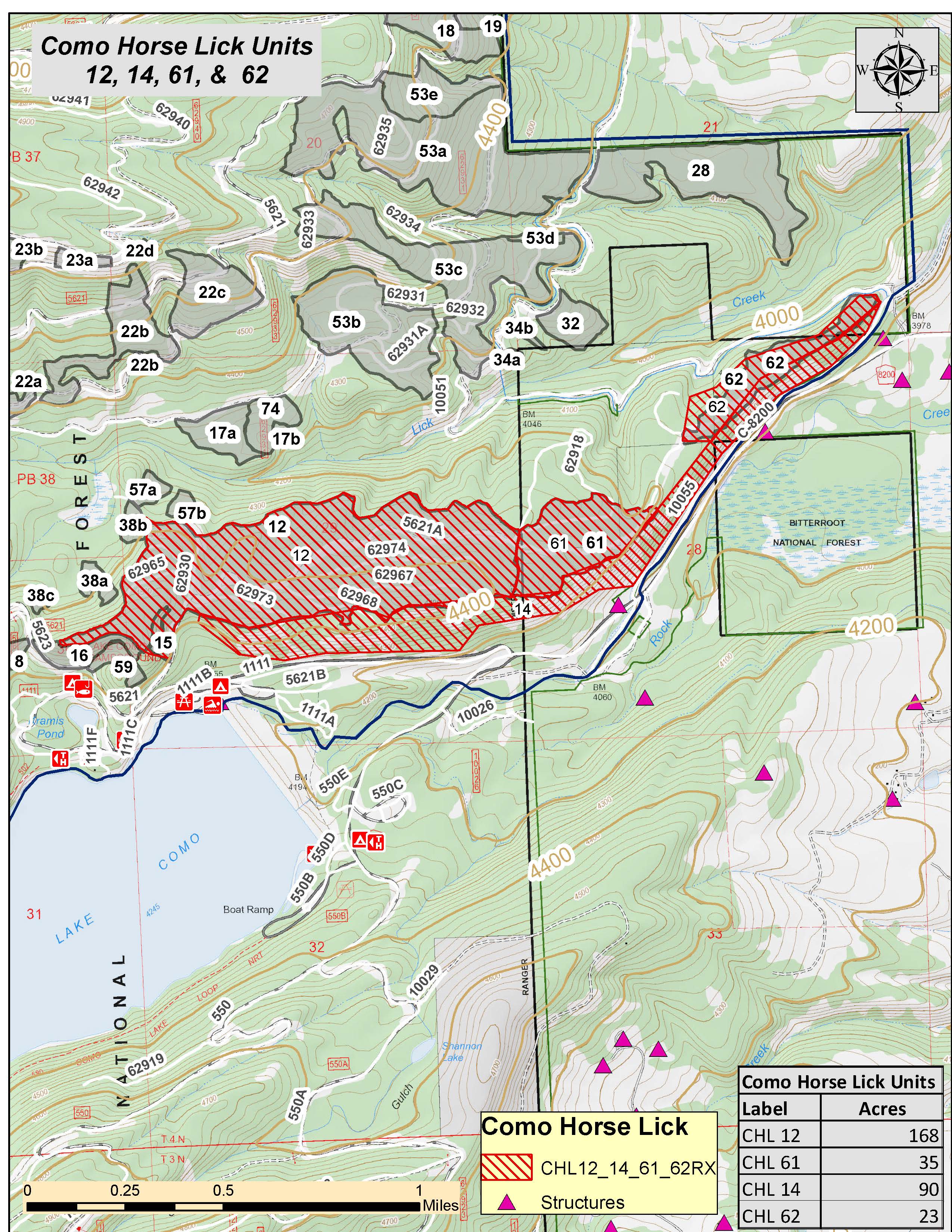
April 14 Como Horse Lick Update
Related Incident:
Publication Type: Announcement
Ignitions are complete on the Como Horse Lick Prescribed Fire, north of Lake Como and south of Lost Horse. Firefighters successfully treated 22 acres by reducing hazardous fuels and improving wildlife habitat. Low-intensity fire creates snags, gaps and clumps of vegetation providing habitat for birds and wildlife. Prescribed Fire helps drive the nutrient cycle and stimulates the growth of new grasses and shrubs that provide wildlife forage.
Crews will be on site patrolling and monitoring the unit. Light smoke may be visible throughout the evening. 

April 14 Prescribed Burn Update
Related Incident:
Publication Type: Announcement
Today Bitterroot NF firefighters plan to under burn 30 acres on the Darby/Sula Ranger District to rejuvenate wildlife habitat and reduce wildfire risk. Firefighters will be hand-igniting Como Horse Lick Unit 53A, north of Lake Como. Scheduled ignition time is around 10 AM. Smoke may be visible from the Highway 93 corridor in the Lost Horse area.
Prescribed burning operations will only be implemented if operational safety, fuel moisture, weather conditions, and air quality parameters can be attained. All spring burning projects are coordinated with the Montana DEQ to minimize impacts to communities.
April 12 Larry Bass Burn Rescheduled
Related Incident:
Publication Type: Announcement
Due to cooler temperatures and light precipitation over the weekend and unfavorable weather forecasted the Larry/Bass Prescribed Fire is RESCHEDULED at the Bass Creek Recreation Area near Stevensville. The reschedule date is to be determined possibly later this week, pending favorable conditions. The 280-acre burn will temporarily impact some roads and trails in the recreation area for 2-3 days.
For more information or to be placed on a pre-burning notification list, contact the Stevensville Ranger District at 406-777-5461. For burn updates, maps, and photos of treatment areas, visit us at www.fs.usda.gov/bitterroot or Bitterroot National Forest Facebook page.
April 7 Prescribed Burn Update Sula Ranger District
Related Incident:
Publication Type: Announcement
Weather permitting, Bitterroot National Forest firefighters plan to burn 10 acres (horse pasture and ditches) around the Sula Ranger Station this afternoon. Scheduled ignition time is around noon.
12 firefighters and two engines are assigned to the burn. Smoke will likely be visible from Sula and Highway 93.
Prescribed burning operations will only be implemented if conditions are favorable. Favorable conditions include correct temperature, wind, fuel moisture, and ventilation for smoke. All spring burning projects are coordinated with the Montana DEW to minimize impacts to communities.
Map of the unit is located below in the Related Information section.
April 4 Prescribed Burn Update
Related Incident:
Publication Type: Announcement
PRESCRIBED BURN UPDATE (April 4, 2021) Burn operations began around 11am this morning on the 50 acre prescribed fire north of Lake Como. 15 firefighters and two engines are assigned to the project. Smoke will again be visible south of Hamilton and north of Darby today. The burn is scheduled to be completed around 4pm this afternoon.
Firefighters utilize drip torches to conduct the underburn operation. The fire stays on the ground and consuming dead vegetation to make way for new, leafy forage. Underburning, a type of prescribed fire treatment, ignites vegetation under the forest canopy or in open grassy meadows and focuses on the consumption of surface fuels. This treatment reduces potential for large wildfires, maintains resilient landscapes, and improves overall forest health. View video here: Bitterroot National Forest Facebook.
Maps of the unit are located below in the Related Information section. 
April 3 Prescribed Burn Update
Related Incident:
Publication Type: Announcement
PRESCRIBED BURN UPDATE (April 3, 2021): Did you see smoke today south of Hamilton near Lake Como? That smoke was from the Como/Horse Lick prescribed burn operation conducted by firefighters on the Darby Ranger District. Firefighters burned approximately 50 acres north of the recreation area to reduce hazardous fuels that are at-risk of wildfire and near communities.
This photos was taken of the underburn operations, see "Photo Tab" for more pictures. Underburning is a type of prescribed fire method that ignites the surface fuel under the forest canopy such as leaf litter, pine needles, grass, and small vegetation. Firefighters used Como Road as a containment line as the fire worked its way around the larger, fire-adapted trees.
Pending favorable conditions, crews will resume burning operations tomorrow around 11am at Lake Como. Smoke will again be visible from Hamilton and Darby. As a reminder, no closures are in place, but please give firefighters plenty of space if you are in the area. Firefighters will continue to implement, monitor, and patrol this burn over the next several days to ensure it meets forest health and public safety goals including air quality.
Maps of the unit are located below in the Related Information section.

Lake Como Prescribed Burn Planned April 3 4
Related Incident:
Publication Type: Announcement
Weather permitting, Bitterroot National Forest firefighters are planning to conduct underburning operations this weekend (April 3rd and 4th) north of Lake Como. 90 acres are scheduled on Saturday and 23 acres are planned for Sunday. Scheduled ignition time is noon both days. 17 firefighters and two engines are assigned to the burn. Smoke will likely be visible from the main Como Road and beach area.
Underburning ignites vegetation under the forest canopy to reduce hazardous fuels. Prescribed burning operations will only be implemented if conditions are favorable. Favorable conditions include correct temperature, wind, fuel moisture, and ventilation for smoke. When these criteria are met, firefighters implement, monitor, and patrol each burn to ensure it meets forest health and public safety goals including air quality.
All spring burning projects are coordinated with the Montana DEQ to minimize impacts to communities. At this time, no closures are expected to be in place; however, please be aware that firefighters will be in the area and avoid places where they are working.
Thank you local communities and public for your support! Fire officials say smoke now is a much better alternative for the forest and our communities than smoke from an uncontrolled summer wildfire. Periodic prescribed burns prevent heavy fuel accumulation that would send a larger amount of smoke into the air should a wildfire occur.
Maps of the unit are located below in the Related Information section. 

