
Telegraph Fire Evening Update June 16 2021
Related Incident:
Publication Type: News
Fire Information Public Phone Line: 480-608-2054
Fire Information Media Phone Line: 949-573-5408
Email: 2021.Telegraph@firenet.gov
Telegraph Fire Evening Update – June 16, 2021
Notifications can change rapidly. Residents in areas affected by the fire should remain vigilant and be prepared to evacuate. Evacuation notifications are issued when danger is imminent and life threatening.
Acres: 165,740
Structures damaged/destroyed: 42
CLOSURE AREAS: Tonto National Forest Closure Order Map: https://www.fs.usda.gov/alerts/tonto/alerts-notices
Bureau of Land Management Emergency Fire Closure Order and Map: https://www.facebook.com/BLMArizona/
Ray Mine Riverside Kearny Winkleman Hayden on READY status
Related Incident:
Publication Type: Announcement
The Pinal County Sheriff's Office has put Ray Mine, Riverside, Kearny, Winkleman, and Hayden on “READY” status due to the spread of the Telegraph Fire. READY means Prepare Now. Make a family evacuation plan, build a 72-hour emergency go kit, and check with your neighbors to ensure they are READY too. Find Pinal County evacuation information on the Pinal County Sheriff's Office Facebook page - https://www.facebook.com/PinalCountySO
Actualizacin matutina del incendio del telgrafo 16 de junio de 2021
Related Incident:
Publication Type: News
Información sobre incendios: 480-608-2054
Consultas de los medios: 949-573-5408
Email: 2021.Telegraph@firenet.gov
InciWeb: https://inciweb.nwcg.gov/incident/7512/
Facebook: https://www.facebook.com/Telegraphfireinformation/
Twitter: https://twitter.com/TelegraphFire
Actualización matutina del incendio del telégrafo - 16 de junio de 2021
PARA OBTENER INFORMACIÓN ACTUAL SOBRE LA EVACUACIÓN, se recomienda a los residentes monitorear regularmente las páginas de Facebook de Pinal County Sheriff’s Office: https://www.facebook.com/PinalCountySO, Gila County Health and Emergency Management: https://www.facebook.com/gilacohealthem , y San Carlos Apache Tribe Emergency Response Commission: San Carlos Apache Tribe Emergency Response Commission - Home | Facebook.
Las notificaciones pueden cambiar rápidamente. Los residentes en las áreas afectadas por el incendio deben permanecer atentos y estar preparados para evacuar. Las notificaciones de evacuación se emiten cuando el peligro es inminente y amenaza la vida.
TAMAÑO EN ACRES: 148,299 PERSONAL TOTAL: 1,038
Contención: 59% CAUSA: Humana, Bajo investigacion
FECHA / HORA DETECTADA: Viernes , 6/4/2021 1:30pm Origin/Origen / Ubicación: South of Superior, Arizona
Estructuras quemadas: 22
Ayer por la tarde, cerca de las 18:00 horas, los fuertes vientos de las tormentas empujaron el fuego hacia el sur a través de Dripping Springs Road. Los bomberos utilizaron una carretera por encima de la mina Ray como punto de anclaje para quemar una línea de contención alrededor del incendio puntual, impidiendo una mayor propagación. Las cuadrillas continuaron preparando en y alrededor de los valores en riesgo a lo largo de la carretera de Dripping Springs. Los bomberos quemaron el combustible alrededor de la torre de comunicaciones de Telemundo en la zona de Signal Peak para evitar daños a la torre. Los equipos de protección de estructuras trabajaron para proteger los valores en riesgo en las áreas de El Capitán y a lo largo de Dripping Springs Road.
Hoy los bomberos mantendrán una fuerte presencia en las comunidades de El Capitan, evaluando los daños y limpiando. Las cuadrillas buscarán oportunidades para conectar la antigua carretera y la línea de dozer que va hacia el noreste desde Dripping Springs hasta el perímetro de Mescal Fire, y el grupo de protección de estructuras identificará y protegerá los valores en riesgo a lo largo de Dripping Springs Road. Los equipos de bomberos continuarán limpiando y reparando la carretera forestal 651 para proporcionar acceso a las actividades de supresión de incendios. La evaluación para la reparación de la supresión en la línea de dozer desde Pioneer Pass Road al este hasta la State Route 77 al norte del Rancho Grantham puede comenzar hoy. En el corredor de la US Route 60, las cuadrillas de tala eliminarán los troncos peligrosos en el interior de la zona quemada. Hoy el equipo de BAER (respuesta de emergencia en áreas quemadas) comenzará a evaluar el área quemada en el corredor de la US 60 en preparación de un plan de rehabilitación. Para obtener información sobre el estado de la evacuación, los cierres de carreteras y la actividad del incendio, habrá una reunión virtual de la comunidad todos los días a las 18:00 horas hasta nuevo aviso, en la página de Facebook del incidente: https://www.facebook.com/Telegraphfireinformation/
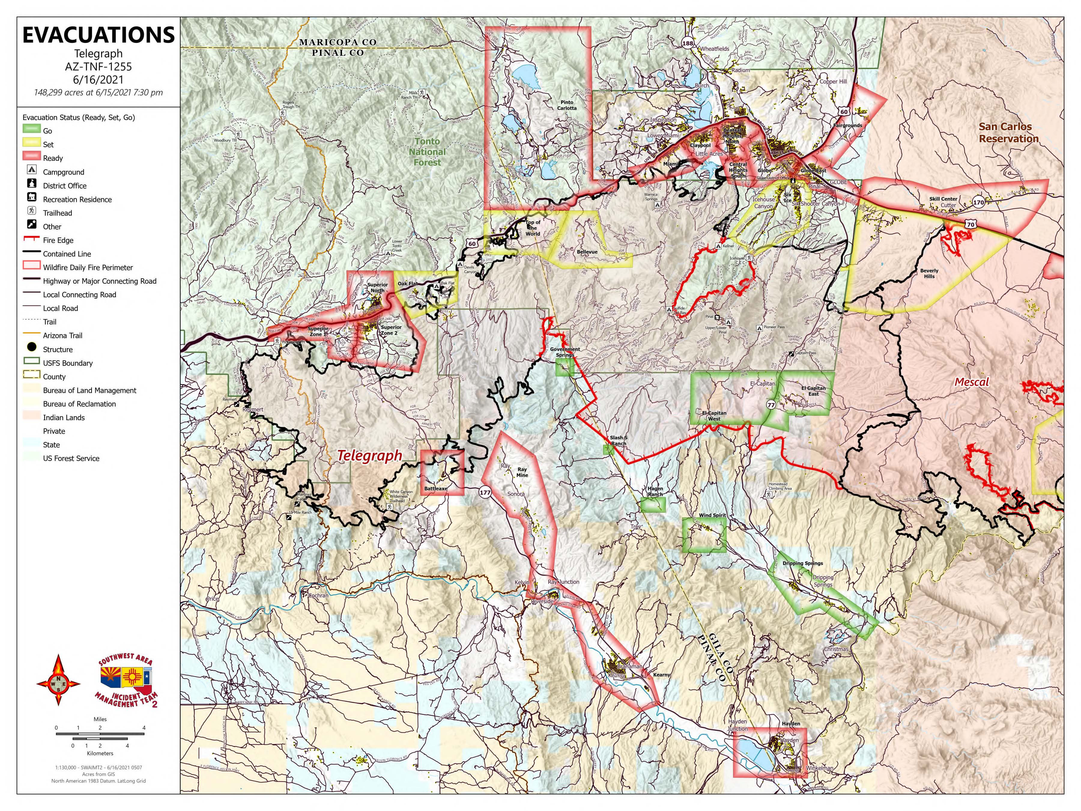
Estado de evacuación para El Capitan (este y oeste), Dripping Springs, Wind Spirit, Hagen Ranch, Slash S Ranch y Government Springs es ahora "Go". Estado de evacuación para Top-of-the-World, Bellevue, Oak Flat, Beverly Hills, Six Shooter y Icehouse y ahora es "Set". El estado de evacuación para Superior, Globe, Miami, Claypool, Central Heights, Pinto/Carlotta, Skill Center, Fairgrounds, Schultz Ranch y el área de Battle Axe es ahora "Listo".
El Bosque Nacional de Tonto ha iniciado la Etapa 2 de Restricciones de Incendios para todo el bosque, a partir de las 8 a.m. del 11 de junio.
Toda la tierra del estado está bajo restricciones de la etapa 2 a partir de las 8 a.m. del 11 de junio.
La Reserva India de San Carlos ha iniciado la Etapa 3 de restricciones contra incendios para toda la reserva, a partir del 14 de junio, 2021.
Todas las tierras de la Oficina de Administración de Tierras en Arizona están bajo restricciones de incendios de la Etapa 2 a partir del 11 de junio de 2021. Véase: https://blm.gov/arizona/fire-restrictions
ÁREAS DE CIERRE: Mapa de orden de cierre del Bosque Nacional de Tonto: https://www.fs.usda.gov/alerts/tonto/alerts-notices
Orden y mapa de cierre de incendios de emergencia del Bureau of Land Management: https://www.facebook.com/BLMArizona/
New Smoke Forecast June 16 and June 17
Related Incident:
Publication Type: News
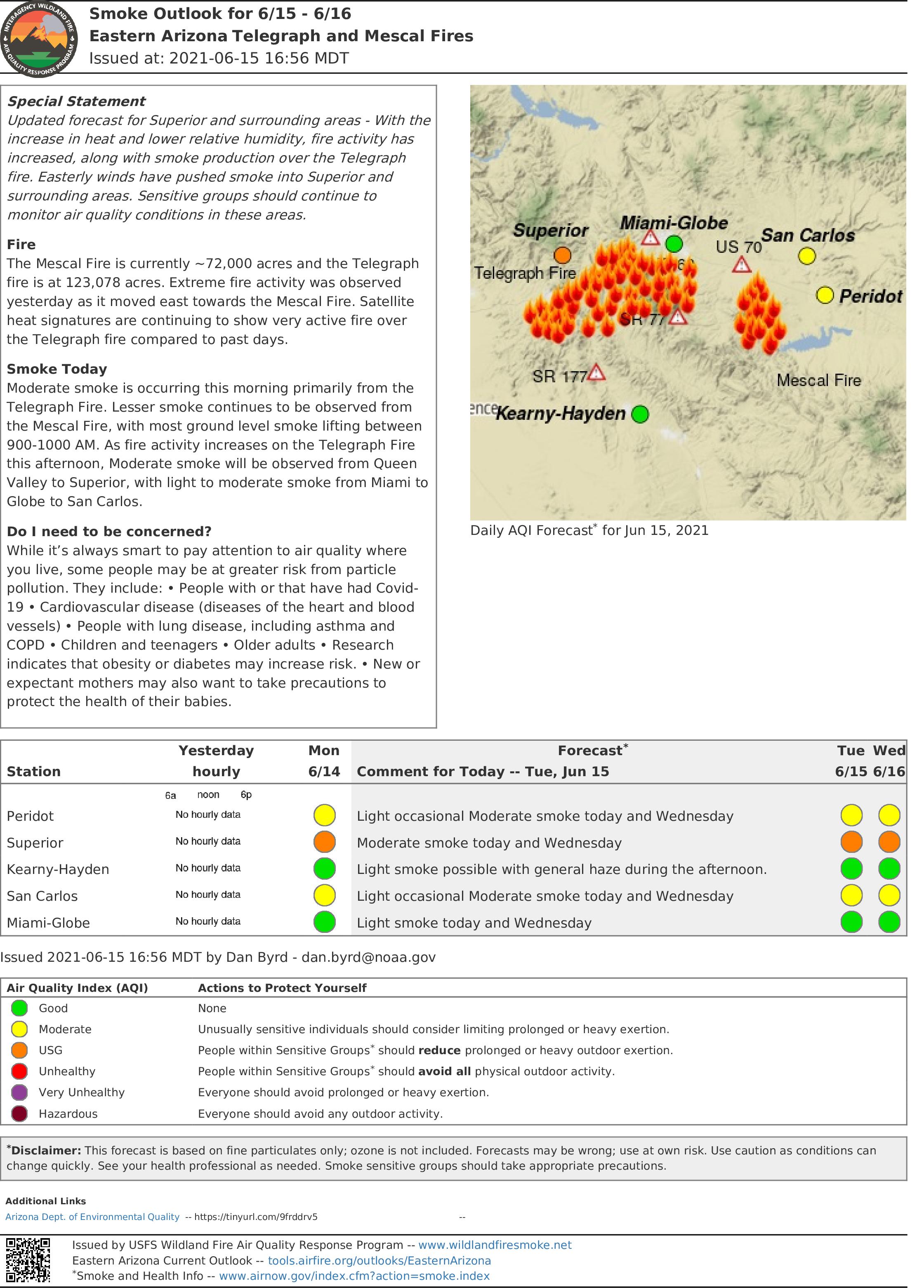
Special Statement: With the increase in heat and lower relative humidity, fire activity has continued to be very active, along with smoke production over the Telegraph fire. Easterly winds have continued to push smoke into Superior and surrounding areas. Sensitive groups should continue to monitor air quality conditions in these areas. As the afternoon progresses, outflow winds from thunderstorms to the northeast, could increase fire activity and thus smoke to areas southwest, west and northwest of the fire. Areas to the east of the fire will see less impacts, but will continue to see light smoke and increased levels of ozone.
Telegraph Fire Facebook Live Virtual Community Meeting 616 at 6 pm
Related Incident:
Publication Type: Announcement
Telegraph Fire Virtual Community Meeting Tonight 6 p.m June 16, 2021: https://www.facebook.com/Telegraphfireinformation/
Telegraph Fire Morning Update June 16 2021
Related Incident:
Publication Type: News
Fire Information Public Phone Line: 480-608-2054
Fire Information Media Phone Line: 949-573-5408
Email: 2021.Telegraph@firenet.gov
InciWeb: https://inciweb.nwcg.gov/incident/7512/
Facebook: https://www.facebook.com/Telegraphfireinformation/
NEW Twitter: https://twitter.com/TelegraphFire s
Telegraph Fire Morning Update – June 16, 2021
FOR CURRENT EVACUATION INFORMATION, residents are advised to monitor Facebook pages for Pinal County Sheriff’s Office: https://www.facebook.com/PinalCountySO, Gila County Health and Emergency Management: https://www.facebook.com/gilacohealthem , and San Carlos Apache Tribe Emergency Response Commission: San Carlos Apache Tribe Emergency Response Commission - Home | Facebook.
Notifications can change rapidly. Residents in areas affected by the fire should remain vigilant and be prepared to evacuate. Evacuation notifications are issued when danger is imminent and life threatening.
Acres: 148,299
Percent Containment: 59%
Date/Time Detected: Friday, June 4, 2021, 1:30 p.m.
Structures burned: 22
Number of Personnel: 1,038
Cause: Human, under investigation
Origin/Location: South of Superior, Arizona
Yesterday evening at about 6 p.m., strong outflow winds from thunderstorms pushed fire south across Dripping Springs Road. Crews used a road above Ray Mine as an anchor point to burn out a containment line around the spot fire, preventing further spread. Crews continued to prep in and around the values at risk along the Dripping Springs Road. Firefighters burned out fuel around the Telemundo communications tower on Signal Peak area to prevent damage to the tower. Structure protection crews worked to protect values at risk in the areas of El Capitan and along Dripping Springs Road.
Today firefighters will maintain a heavy presence in the El Capitan communities, assessing damage and mopping up. Crews will search for opportunities to connect the old road and dozer line running northeast from Dripping Springs to the Mescal Fire perimeter, and Structure Protection group will identify and protect values at risk along Dripping Springs Road. Fire crews will continue to clean up and repair Forest Road 651 to provide access for fire suppression activities. Assessment for suppression repair on the dozer line from Pioneer Pass Road east to State Route 77 north of the Grantham Ranch may begin today. In the U.S. Route 60 corridor, felling crews will remove hazardous snags within the interior of the burned area. Today the BAER (burned area emergency response) team will begin assessment of the burned area in the US 60 corridor in preparation for a rehabilitation plan. For information on evacuation status, road closures, and fire activity, there will be a virtual community meeting every day at 6 p.m. until further notice, on the Incident Facebook page: https://www.facebook.com/Telegraphfireinformation/
Evacuation status for El Capitan (east and west), Dripping Springs, Wind Spirit, Hagen Ranch, Slash S Ranch and Government Springs is now “Go.” Evacuation status for Top-of-the-World, Bellevue, Oak Flat, Beverly Hills, Six Shooter and Icehouse and is now “Set.” Evacuation status for Superior, Globe, Miami, Claypool, Central Heights, Pinto/Carlotta, Skill Center, Fairgrounds, Schultz Ranch and the Battle Axe area is now “Ready.”
The Tonto National Forest has initiated Stage 2 Fire Restrictions for the entire forest, effective 8 a.m. on June 11.
All State Land is under Stage 2 restrictions effective 8 a.m. on June 11.
The San Carlos Indian Reservation has initiated Stage 3 fire restrictions for the entire reservation, effective June 14,
2021.
All Bureau of Land Management lands in Arizona are under Stage 2 fire restrictions effective June 11, 2021. See: https://blm.gov/arizona/fire-restrictions
CLOSURE AREAS: Tonto National Forest Closure Order Map: https://www.fs.usda.gov/alerts/tonto/alerts-notices
Bureau of Land Management Emergency Fire Closure Order and Map: https://www.facebook.com/BLMArizona/
###Telegraph Fire Evacuation Status and Closure Update June 16 2021
Related Incident:
Publication Type: News
Fire Information Public Phone Line: 480-608-2054
Fire Information Media Phone Line: 949-573-5408
Email: 2021.Telegraph@firenet.gov
InciWeb: https://inciweb.nwcg.gov/incident/7512/
Facebook: https://www.facebook.com/Telegraphfireinformation/
NEW Twitter: https://twitter.com/TelegraphFire
Telegraph Fire Evacuation Status and Closure Update – June 16, 2021
FOR CURRENT EVACUATION INFORMATION, residents are advised to monitor Facebook pages for Pinal County Sheriff’s Office: https://www.facebook.com/PinalCountySO and Gila County Health and Emergency Management: https://www.facebook.com/gilacohealthem and San Carlos Apache Tribe Emergency Response Commission: San Carlos Apache Tribe Emergency Response Commission - Home | Facebook. Notifications can change rapidly. Residents in areas affected by the fire should remain vigilant and be prepared to evacuate. Evacuation notifications are issued when danger is imminent and life threatening.
Temporary shelters have been set up at the High Desert Middle School, and the Gibson Wash Activity Center. Small animals can be taken to the Gila County Animal Care and Control center. The Apache Gold Casino RV Park is accepting evacuees with camp trailers, and livestock may be held at the Apache Gold Pavilion. Pet and livestock owners are responsible for their animals. The San Carlos Apache Tribe Emergency Response Commission have information on evacuations at: 928-475-2008. Gila County Emergency Management has activated a call center for information on sheltering if you evacuate due to the wildfire: 928-910-4009 8 a.m.-5 p.m.
READY, SET, GO! INFORMATION: https://ein.az.gov/ready-set-go
Evacuation status for the communities of El Capitan (east and west), Dripping Springs, Wind Spirit, Hagen Ranch, Slash S Ranch and Government Springs are now “Go”
Evacuation status for Top-of-the-World, Bellevue, Oak Flat, Beverly Hills, Six Shooter and Icehouse are now “Set.”
Evacuation status for Superior, Globe, Miami, Claypool, Central Heights, Pinto/Carlotta, Skill Center, Fairgrounds, Schultz Ranch and the Battle Axe area are now “Ready.”
CLOSURE AREAS: Tonto National Forest has revised its Closure Order and Map: https://www.fs.usda.gov/alerts/tonto/alerts-notices
Bureau of Land Management Emergency Fire Closure Order and Map: https://www.facebook.com/BLMArizona/. The Bureau of Land Management has closed all public lands under its jurisdiction in Gila County in the vicinity of the Telegraph fire. See: https://blm.gov/arizona/fire-restrictions
ROAD CLOSURES: Arizona Department of Transportation Interactive Map: https://az511.gov/
The San Carlos Indian Reservation has initiated Stage 3 fire restrictions for the entire reservation, effective June 14, 2021. The Tonto National Forest has initiated Stage 2 Fire Restrictions for the entire forest, effective 8 a.m. on June 11.
All State Land is under Stage 2 restrictions effective 8:00 AM on June 11.
All Bureau of Land Management lands in Arizona are under Stage 2 fire restrictions effective June 11, 2021. See: https://blm.gov/arizona/fire-restrictions
For information on evacuation status, road closures, and fire activity, there will be a virtual community meeting every day at 6 pm until further notice, on the Incident Facebook page: https://www.facebook.com/Telegraphfireinformation/
Actualizacin de la noche del incendio del telgrafo 15 de junio de 2021
Related Incident:
Publication Type: News
Información sobre incendios: 480-608-2054
Actualización de la noche del incendio del telégrafo - 15 de junio de 2021
Para obtener información actualizada sobre la evacuación, se aconseja a los residentes que sigan las páginas de Facebook de la https://www.facebook.com/PinalCountySO, Gila County Health and Emergency Management: https://www.facebook.com/gilacohealthem , and San Carlos Apache Tribe Emergency Response Commission: San Carlos Apache Tribe Emergency Response Commission - Home | Facebook.
Las notificaciones pueden cambiar rápidamente. Los residentes de las zonas afectadas por el incendio deben permanecer atentos y estar preparados para evacuar. Las notificaciones de evacuación se emiten cuando el peligro es inminente y amenaza la vida.
TAMAÑO EN ACRES: 139,615 PERSONAL TOTAL: 1,038
Contención: 59% CAUSA: Humana, Bajo investigacion
FECHA / HORA DETECTADA: Viernes , 6/4/2021 1:30pm Origin/Origen / Ubicación: South of Superior, Arizona
Estructuras quemadas: 22
Hoy las cuadrillas de protección de estructuras en el área de El Capitan continúan suprimiendo el fuego, asegurando los valores y evaluando el daño causado. Los bomberos mejoraron, limpiaron y aseguraron con éxito la línea de contención desde la SR 77 hacia el este hasta el perímetro occidental del incendio de Mescal hoy para detener la propagación del fuego hacia el noreste. Las cuadrillas trabajaron en la remoción de escombros y obstáculos en la carretera 651 para abrir el acceso a las torres de comunicación en Signal y Pinal Peaks. El fuego continuó retrocediendo ladera abajo en el lado sur hacia Dripping Springs Road. Los bomberos continúan explorando las posibles ubicaciones de las líneas en este frente, desde el rancho Government Springs hacia el este hasta el borde del incendio de Mescal. También en esta zona, las fuerzas de protección de estructuras identificarán y asegurarán los valores en riesgo. En el lado norte del incendio, bomberos patrullaron y limpiaron los fuego puntual no quemado a lo largo de la U.S. Route 60. Los bomberos seguirán patrullando y limpiando esta noche. Para obtener información sobre el estado de la evacuación, los cierres de carreteras y la actividad del incendio, habrá una reunión virtual de la comunidad todos los días a las 18:00 horas hasta nuevo aviso, en la página de Facebook del incidente: https://www.facebook.com/Telegraphfireinformation/
Estado de evacuación para El Capitán (este y oeste), Dripping Springs, Wind Spirit, Hagen Ranch, Slash S Ranch y Government Springs y es ahora "Go". El estado de evacuación para Top-of-the-World, Bellevue, Oak Flat, Beverly Hills, Six Shooter y Icehouse es ahora "Set". El estado de evacuación para Superior, Globe, Miami, Claypool, Skill Center, Central Heights, Pinto/Carlotta y el área de Battle Axe es ahora "Listo".
El Bosque Nacional de Tonto ha iniciado la Etapa 2 de Restricciones de Incendios para todo el bosque, a partir de las 8 a.m. del 11 de junio.
Todas las tierras estatales están bajo restricciones de la etapa 2 a partir de las 8:00 AM del 11 de junio.
Todas las tierras de la Oficina de Administración de Tierras en Arizona están bajo restricciones de incendios de la Etapa 2 a partir del 11 de junio. Ver: https://blm.gov/arizona/fire-restrictions
ÁREAS DE CIERRE: El Bosque Nacional de Tonto ha revisado su Orden y Mapa de Cierre: https://www.fs.usda.gov/alerts/tonto/alerts-notices
Orden y mapa de cierre de incendios de emergencia del Bureau of Land Management: https://www.facebook.com/BLMArizona/
Telegraph Fire Evening Update June 15 2021
Related Incident:
Publication Type: News
Fire Information Public Phone Line: 480-608-2054
Fire Information Media Phone Line: 949-573-5408
Email: 2021.Telegraph@firenet.gov
InciWeb: https://inciweb.nwcg.gov/incident/7512/
Facebook: https://www.facebook.com/Telegraphfireinformation/
Twitter: https://twitter.com/TelegraphFire
Telegraph Fire Evening Update – June 15, 2021
FOR CURRENT EVACUATION INFORMATION, residents are advised to monitor Facebook pages for Pinal County Sheriff’s Office: https://www.facebook.com/PinalCountySO, Gila County Health and Emergency Management: https://www.facebook.com/gilacohealthem , and San Carlos Apache Tribe Emergency Response Commission: San Carlos Apache Tribe Emergency Response Commission - Home | Facebook.
Notifications can change rapidly. Residents in areas affected by the fire should remain vigilant and be prepared to evacuate. Evacuation notifications are issued when danger is imminent and life threatening.
Acres: 139,615
Percent Containment: 59%
Date/Time Detected: Friday, June 4, 2021, 1:30 pm Structures burned: 22
Number of Personnel: 1,038
Cause: Human, under investigation
Origin/Location: South of Superior, Arizona
Today structure protection crews in the El Capitan area are continuing to suppress fire, secure values and assess damage. Firefighters successfully improved, mopped up, and secured containment line from SR 77 east to the Mescal Fire’s western perimeter today to stop fire spread to the northeast. Crews worked by removing debris and snags on the 651 road to open road access to the communications towers on Signal and Pinal Peaks. The fire continued to back downslope on the south side toward Dripping Springs Road. Firefighters are continuing to scout potential line locations on this front, from Government Springs Ranch east to the Mescal Fire edge. Also in this area, structure protection forces will identify and secure values at risk. On the north side of the fire, crews patrolled and mopped up pockets of unburned fuel along U.S. Route 60. Firefighters will continue to patrol and mop up tonight. For information on evacuation status, road closures, and fire activity, there will be a virtual community meeting every day at 6 p.m. until further notice, on the Incident Facebook page: https://www.facebook.com/Telegraphfireinformation/
Evacuation status for El Capitan (east and west), Dripping Springs, Wind Spirit, Hagen Ranch, Slash S Ranch and Government Springs and is now “Go.” Evacuation status for Top-of-the-World, Bellevue, Oak Flat, Beverly Hills, Six Shooter and Icehouse is now “Set.” Evacuation status for Superior, Globe, Miami, Claypool, Skill Center, Central Heights, Pinto/Carlotta and the Battle Axe area is now “Ready.”
The Tonto National Forest has initiated Stage 2 Fire Restrictions for the entire forest, effective 8 a.m. on June 11.
All State Land is under Stage 2 restrictions effective 8:00 AM on June 11.
All Bureau of Land Management lands in Arizona are under Stage 2 fire restrictions effective June 11, 2021. See: https://blm.gov/arizona/fire-restrictions
CLOSURE AREAS: Tonto National Forest has revised its Closure Order and Map: https://www.fs.usda.gov/alerts/tonto/alerts-notices
Bureau of Land Management Emergency Fire Closure Order and Map: https://www.facebook.com/BLMArizona/
New Smoke Forecast issued for Superior and surrounding communities
Related Incident:
Publication Type: News
Special Smoke Statement - The updated smoke forecast for Superior and surrounding areas is available from the Interagency Wildland Fire Air Quality Response Program https://fires.airfire.org/outlooks/EasternArizona