
Atualizacin matinal sobre el incendio de Telegraph 20 de junio de 2021
Related Incident:
Publication Type: News
Línea de teléfono pública para obtener información sobre el incendio: 480-608-2054
Línea de teléfono para los medios para obtener información sobre el incendio: la nueva línea para los medios estará disponible pronto
Correo electrónico: 2021.Telegraph@firenet.gov InciWeb: https://inciweb.nwcg.gov/incident/7512/
Facebook: https://www.facebook.com/Telegraphfireinformation/ Twitter: https://twitter.com/TelegraphFires
Video de actualización de las operaciones: https://fb.watch/6f9GCUHtoE/
Actualización matinal sobre el incendio de Telegraph – 20 de junio de 2021
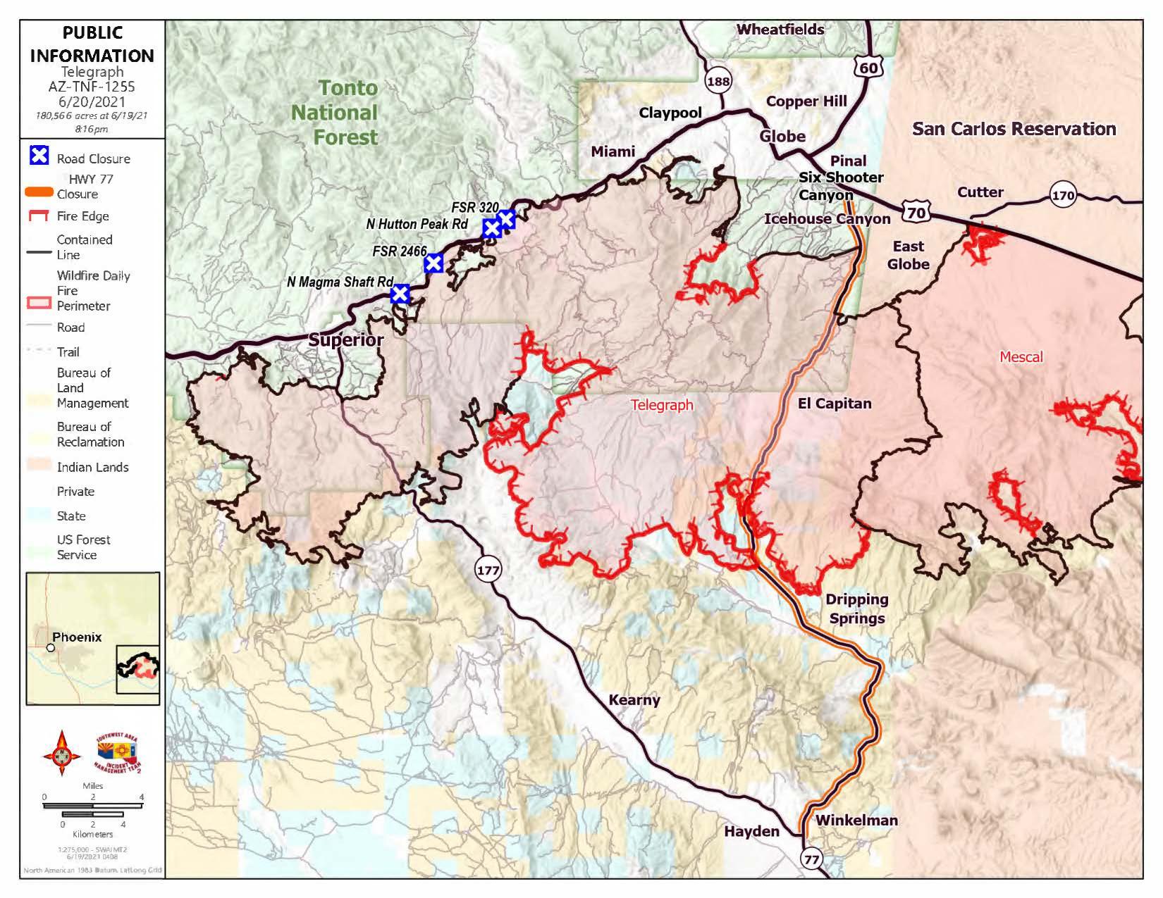
Acres: 180,566
Cantidad de personal: 767
Porcentaje de contención: 67%
Causa: Humana, bajo investigación
Fecha/hora en el que se detectó: Viernes, 4 de junio de 2021,1.30 p. m.
Estructuras quemadas: 52
El Equipo 6 de Manejo de Incidentes del Noroeste asumió el comando del incendio de Telegraph ayer a las 6 p. m.
El Comandante de Incidentes, Shawn Sheldon, desea agradecer a Dave Bales y al Equipo 2 de Manejo de Incidentes del Sudoeste por su arduo trabajo y por favorecer el éxito del equipo entrante.
Durante la noche, los vientos fueron favorables y hubo un incremento limitado del incendio. Los bomberos patrullaron en busca de actividad de incendios a fin de proteger los valores de Dripping Springs, Wind Spirit, Hagen Ranch, Slash S Ranch, El Capitan y junto a State Route 77. El incendio continuó retrocediendo en los pinares en Pinal Mountain hasta la Carretera del Servicio Forestal 651.
Hoy, los fuertes vientos pronosticados podrían generar una rápida propagación del incendio hacia el sudeste de Mescal Mountain. Los equipos utilizarán accesorios de soporte según sea necesario para proteger las líneas de suministro de energía eléctrica que alimentan energía a las comunidades de San Carlos Apache. Los bomberos continuarán monitoreando la actividad del incendio y protegerán a las comunidades e infraestructuras junto a State Route 77, Dripping Springs Road y Ray Mine. El trabajo de reparación de supresión continuará junto al corredor de
U.S. Route 60 y la Carretera del Servicio Forestal 651. El humo podría ser visible a medida que el incendio retrocede hasta la parte superior de Kellner y Icehouse Canyons y a medida que los espacios de vegetación que aún no se quemó dentro del perímetro del incendio atraviesa un aumento de la actividad del incendio. State Route 77 está abierta desde la intersección de State Route 77 y U.S. Route 70 hasta El Capitán, solo para residentes de El Capitán.
Estado de evacuación a las 5:00 p. m., del 19 de junio: Nivel “EVACUAR” - Dripping Springs, Wind Spirit, Hagen Ranch, Slash S Ranch, Government Springs. Estado de evacuación, nivel “ESTAR LISTOS” - El Capitán Este y Oeste, Six Shooter Canyon e Icehouse Canyon. Estado de evacuación “PREPARASE”: Superior, Globe, Miami, Claypool, Central Heights, Pinto/Carlotta, Skill Center, Fairgrounds, Schulze Ranch, Ray Mine, Top-of-the-World, Bellevue, Oak Flat, Beverly Hills, Riverside, Kearney, Winkelman, Hayden, el área de Battle Axe.
_El Departamento de Agricultura de los Estados Unidos (USDA, por sus siglas en inglés) prohíbe en sus programas la discriminación sobre la base de raza, color, origen nacional, sexo, religión, edad, discapacidad, creencias políticas y estado civil o familiar. (No todas las bases prohibidas se aplican a todos los programas) Las personas con discapacidades que necesiten medios alternativos de comunicación de información sobre el programa (Braille, letra grande, cinta de audio, etc.) deben ponerse en contacto con el centro TARGET del USDA, llamando al 202-720-2600 (voz y TDD). Para presentar una queja, escriba a Secretary of Agriculture, U.S. Department of Agriculture, Washington, DC 20250, o llame al 1-800-245-6340 (voz) o al (202) 720-1127 (TDD). USDA es un empleador que ofrece oportunidades equitativas de empleo.
Cierres y restricciones contra incendios: https://wildlandfire.az.gov/fire-restrictions
Mapa y orden de cierre de Telegraph, restricciones contra incendios etapa 2 del Bosque Nacional Tonto: https://www.fs.usda.gov/alerts/tonto/alerts-notices
Restricciones etapa 2 de tierras del estado de Arizona https://dffm.az.gov/fire-restrictions
Mapa y orden de cierre de emergencia por incendio de Telegraph, restricciones de etapa 2 de la Oficina de Administración de Tierras: https://www.facebook.com/BLMArizona/
Restricciones de incendio de etapa 3 de la Reserva Indígena San Carlos https://www.facebook.com/SCATFORESTRY
Telegraph Fire Morning Update June 20 2021
Related Incident:
Publication Type: News
Fire Information Public Phone Line: 480-608-2054
Fire Information Media Phone Line: new media line will be available soon
Email: 2021.Telegraph@firenet.gov
InciWeb: https://inciweb.nwcg.gov/incident/7512/
Facebook: https://www.facebook.com/Telegraphfireinformation/
Twitter: https://twitter.com/TelegraphFires
Video of operations update: https://fb.watch/6f9GCUHtoE/
Telegraph Fire Morning Update – June 20, 2021
Acres: 180,566 Number of Personnel: 767
Percent Containment: 67% Cause: Human, under investigation
Date/Time Detected: Friday, June 4, 2021, 1:30 p.m. Origin/Location: South of Superior, Arizona
Structures burned: 52
Northwest Incident Management Team 6 assumed command of the Telegraph Fire yesterday at 6 p.m.
Overnight, winds were favorable and there was limited fire growth. Firefighters patrolled for fire activity to protect values in Dripping Springs, Wind Spirit, Hagen Ranch, Slash S Ranch, El Capitan, and along State Route 77. The fire continued to back down through pine stands on Pinal Mountain to Forest Service road 651.
Today, forecasted strong winds may produce rapid fire spread to the southeast from Mescal Mountain. Crews will utilize holding features as necessary to protect the electrical power transmission lines supplying the San Carlos Apache communities. Firefighters will continue to monitor for fire activity and protect communities and infrastructure along State Route 77, Dripping Springs Road, and Ray Mine. Suppression repair work will continue along the U.S. Route 60 corridor and Forest Service road 651. Smoke may be visible as fire backs down upper Kellner and Icehouse Canyons and as pockets of unburned vegetation within the fire perimeter experience increased fire activity. State Route 77 is open from the junction of State Route 77 and U.S. Route 70 to El Capitan for El Capitan residents only.
Evacuation status as of 5 p.m. June 19: “GO” - Dripping Springs, Wind Spirit, Hagen Ranch, Slash S Ranch, Government Springs. Evacuation status “SET” - El Capitan East and West, Six Shooter and Icehouse Canyons. Evacuation status” READY” - Superior, Globe, Miami, Claypool, Central Heights, Pinto/Carlotta, Skill Center, Fairgrounds, Schulze Ranch, Ray Mine, Top-of-the-World, Bellevue, Oak Flat, Beverly Hills, Riverside, Kearney, Winkelman, Hayden, Battle Axe area.
Closures and Fire Restrictions: https://wildlandfire.az.gov/fire-restrictions
Tonto National Forest-Stage 2 Fire Restrictions, Telegraph Closure Order and Map: https://www.fs.usda.gov/alerts/tonto/alerts-notices
Arizona State Lands-Stage 2 Restrictions https://dffm.az.gov/fire-restrictions
Bureau of Land Management-Stage 2 Fire Restrictions, Telegraph Emergency Fire Closure Order and Map: https://www.facebook.com/BLMArizona/
Telegraph Fire Morning Video Update June 20 2021
Related Incident:
Publication Type: News
The Telegraph Fire morning video update for June 20 is available on Facebook at https://fb.watch/6f9GCUHtoE/
Actualizacin matinal sobre el incendio Telegraph 19 de junio de 2021
Related Incident:
Publication Type: News
Línea de teléfono pública para obtener información sobre el incendio: 480-608-2054
Línea de teléfono para los medios para obtener información sobre el incendio: 949-573-5408
Correo electrónico: 2021.Telegraph@firenet.gov
Actualización matinal sobre el incendio Telegraph – 19 de junio de 2021
Viernes, 4 de junio de 2021, 1:30 p. m. Estructuras quemadas: 51
CIERRE DE ÁREAS: Mapa de la orden de cierre del Bosque Nacional Tonto: https://www.fs.usda.gov/alerts/tonto/alerts-notices
Mapa y orden de cierre de emergencia por incendio de la Oficina de Administración de Tierras: https://www.facebook.com/BLMArizona/
BLM Gila District Emergency Fire Closure
Related Incident:
Publication Type: Closures
United States Department of the Interior
BUREAU OF LAND MANAGEMENT
Gila District Office
3201 East Universal Way
Tucson, Arizona 85756
June 19, 2021
EMERGENCY FIRE CLOSURE
Public Lands in Gila County in the Vicinity of the Telegraph Fire
Bureau of Land Management
Tucson Field Office, Gila District
The Telegraph Fire began on June 4, 2021, and the current fire perimeter reaches from west of the Arizona Trail and on to the San Carlos Apache Reservation to the east, straddling Route 177 and 77. The fire perimeter continues south between the Ray Mine and San Carlos Apache Reservation and includes lands administered by the Tonto National Forest, the Bureau of Land Management, including the White Canyon Wilderness, as well as State-administered lands and lands administered by the San Carlos Apache Tribe and the Bureau of Indian Affairs. There are also private and Arizona State Land Department lands.
Pursuant to 43 CFR 8351.2-1 or 43 CFR 9212.2 (a) and effective at 10:00 p.m. June 19, 2021 until rescinded, given the dynamic and continued growth of the fire, public access is temporarily prohibited to public lands in Pinal and Gila Counties within the Telegraph Fire Operational Area as noted below. This Emergency Fire Closure incorporates and supersedes closures issued on June 6 and 14, 2021.
Closure applies to public lands within the area bounded as follows:
• West to Sandman Road, including a portion of Cottonwood Canyon Road,
• South to the Gila River and along State Route 177 Winkleman,
• East to the San Carlos Apache Reservation, and
• North to the junction of Highway 60 and State Route 188.
Temporary Prohibited Acts:
1. Entry to public lands by motorized use, pedestrian or equestrian use, and recreational use unless a specific exemption has been granted.
2. Entry to White Canyon Wilderness.
A violation of this closure is punishable by a fine of not more than $1,000.00 or imprisonment of not more than 12 months, or both.
Exempted: Except in emergency conditions or permission by an agency authorized officer, there are no exceptions to this closure.
Acting Associate District Manager
Bureau of Land Management
Gila DistrictTelegraph Fire Morning Update June 19 2021
Related Incident:
Publication Type: News
Fire Information Public Phone Line: 480-608-2054
Fire Information Media Phone Line: 949-573-5408
Email: 2021.Telegraph@firenet.gov
InciWeb: https://inciweb.nwcg.gov/incident/7512/
Facebook: https://www.facebook.com/Telegraphfireinformation/
Twitter: https://twitter.com/TelegraphFires
Telegraph Fire Morning Update – June 19, 2021
Acres: 179,678
Percent Containment: 67%
Date/Time Detected: Friday, June 4, 2021, 1:30 p.m. Structures burned: 51
Number of Personnel: 915
Cause: Human, under investigation
Origin/Location: South of Superior, Arizona
Overnight, firefighters successfully used existing road systems to keep the fire from impacting Government Springs Ranch. Crews continued to monitor the fire backing down in pine stands on Pinal Peak. Firefighters maintained a presence in El Capitan, and the communities along Dripping Springs Road.
Today, members of the Pacific Northwest Incident Management Team 6 will work alongside current fire managers to gain familiarity with the area, fire conditions, and available resources prior to taking over management of the fire today at 6 p.m. Crews will continue to monitor the fire near Government Springs Ranch and ensure that values at risk are not impacted. Heavy equipment may be visible along the U.S. Route 60 as crews continue suppression repair work to rehabilitate suppression lines. Smoke will still be visible from the slow fire spread on Pinal Mountain. Crews will monitor the fire as it backs down Mescal Mountain and utilize control features as necessary to protect the powerline, communities, and infrastructure along State Route 77. State Route 77 is open from the junction of State Route 77 and U.S. Route 70 to El Capitan for El Capitan residents only. This will be the last update from the Southwest Area Type 1 Incident Management Team 2.
Evacuation status as of 7 a.m. June 19: “GO” - Dripping Springs, Wind Spirit, Hagen Ranch, Slash S Ranch, Government Springs. Evacuation status “SET” - El Capitan East and West, Six Shooter and Icehouse Canyons. Evacuation status” READY” - Superior, Globe, Miami, Claypool, Central Heights, Pinto/Carlotta, Skill Center, Fairgrounds, Schulze Ranch, Ray Mine, Top-of-the-World, Bellevue, Oak Flat, Beverly Hills, Riverside, Kearney, Winkelman, Hayden, Battle Axe area.
Notifications can change rapidly. Residents in areas affected by the fire should remain vigilant and be prepared to evacuate. Evacuation notifications are issued when danger is imminent and life threatening.
The Tonto National Forest has initiated Stage 2 Fire Restrictions for the entire forest, effective 8 a.m. on June 11.
All State Land is under Stage 2 restrictions effective 8 a.m. on June 11.
The San Carlos Indian Reservation has initiated Stage 3 fire restrictions for the entire reservation, effective June 14,
2021.
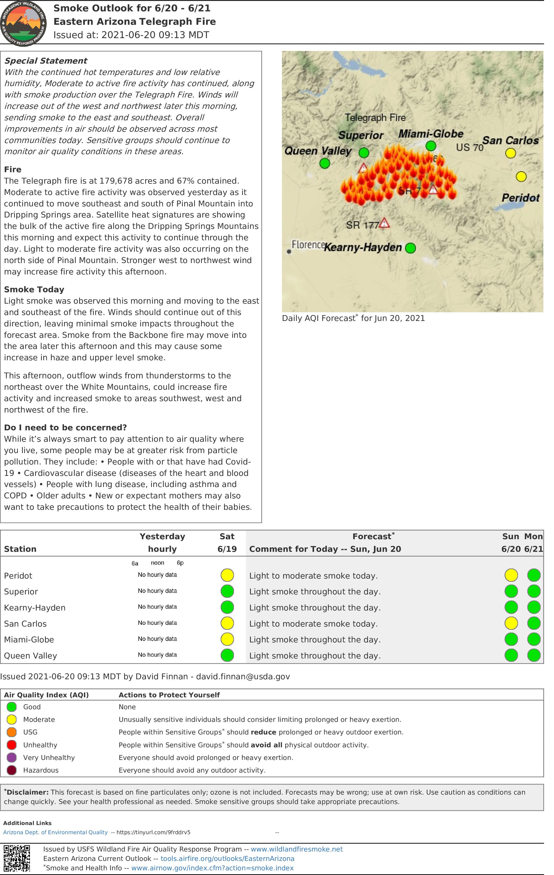
Smoke report is available at https://wildlandfiresmoke.net/outlooks/EasternArizona
All Bureau of Land Management lands in Arizona are under Stage 2 fire restrictions effective June 11, 2021. See: https://blm.gov/arizona/fire-restrictions
CLOSURE AREAS: Tonto National Forest Closure Order Map: https://www.fs.usda.gov/alerts/tonto/alerts-notices
Bureau of Land Management Emergency Fire Closure Order and Map: https://www.facebook.com/BLMArizona/
Telegraph Fire Evening Update June 18 2021
Related Incident:
Publication Type: News
Fire Information Public Phone Line: 480-608-2054
Fire Information Media Phone Line: 949-573-5408
Email: 2021.Telegraph@firenet.gov
InciWeb: https://inciweb.nwcg.gov/incident/7512/
Facebook: https://www.facebook.com/Telegraphfireinformation/
Twitter: https://twitter.com/TelegraphFires
Telegraph Fire Evening Update – June 18, 2021
Acres: 177,295
Percent Containment: 67%
Date/Time Detected: Friday, June 4, 2021, 1:30 p.m.
Structures burned: 51
Number of Personnel: 915
Cause: Human, under investigation
Origin/Location: South of Superior, Arizona
Today: Residents of El Capitan returned to their homes this morning and are now on “Set” evacuation status. Firefighters will mop-up and patrol in this area over the next several days. Crews worked with helicopters to suppress an unburned pocket of brush that flared up north of Government Springs. They also patrolled the SR 77, SR 177, and Dripping Springs Road corridors to protect values at risk and take suppression action where necessary. Firefighters are monitoring the fire as it backs off the Mescal Mountains through rugged, inaccessible terrain in the southeast corner of the fire area, and will take suppression actions if it threatens SR 77. Residents in the Globe-Miami area can expect to see light to moderate smoke for the next few days from the upper Kellner, and Icehouse Canyons as the fire backs down-slope through the area burned by the 2017 Pinal Fire. The Red Cross Evacuation Shelters at Highline Middle School and Skyline High School closed today but are ready to reopen if they’re needed. Suppression repair continued near Top-of-the-World.
Tonight, members of the Pacific Northwest Incident Management Team 6 will work alongside current fire managers to gain familiarity with the area, fire conditions and available resources prior to taking over management of the fire tomorrow afternoon. Firefighters will continue to monitor the fire backing down in pine stands on Pinal Peak. Crews will monitor the fire near Government Springs Ranch, and ensure that values at risk are not impacted. Fire crews will monitor and patrol El Capitan, and the communities along Dripping Springs Road overnight. The Contingency Group will continue to identify roads and other possible contingency lines they can use to contain the fire south of the Troy and Tiger Mountain area and prevent it from spreading south towards SR 177 and the values at risk along that corridor.
Evacuation status as of 11:30 a.m. June 18: “GO” - Dripping Springs, Wind Spirit, Hagen Ranch, Slash S Ranch, Government Springs. Evacuation status “SET” - El Capitan East and West, Six Shooter and Icehouse Canyons. Evacuation status” READY” - Superior, Globe, Miami, Claypool, Central Heights, Pinto/Carlotta, Skill Center, Fairgrounds, Schulze Ranch, Ray Mine, Top-of-the-World, Bellevue, Oak Flat, Beverly Hills, Riverside, Kearney, Winkelman, Hayden, Battle Axe area.
Notifications can change rapidly. Residents in areas affected by the fire should remain vigilant and be prepared to evacuate. Evacuation notifications are issued when danger is imminent and life threatening.
The Tonto National Forest has initiated Stage 2 Fire Restrictions for the entire forest, effective 8 a.m. on June 11.
All State Land is under Stage 2 restrictions effective 8 a.m. on June 11.
The San Carlos Indian Reservation has initiated Stage 3 fire restrictions for the entire reservation, effective June 14, 2021.
All Bureau of Land Management lands in Arizona are under Stage 2 fire restrictions effective June 11, 2021. See: https://blm.gov/arizona/fire-restrictions
CLOSURE AREAS: Tonto National Forest Closure Order Map: https://www.fs.usda.gov/alerts/tonto/alerts-notices
Bureau of Land Management Emergency Fire Closure Order and Map: https://www.facebook.com/BLMArizona/Telegraph Fire Morning Update June 18 2021
Related Incident:
Publication Type: News
Fire Information Public Phone Line: 480-608-2054
Fire Information Media Phone Line: 949-573-5408
Email: 2021.Telegraph@firenet.gov
Telegraph Fire Morning Update – June 18, 2021
Notifications can change rapidly. Residents in areas affected by the fire should remain vigilant and be prepared to evacuate. Evacuation notifications are issued when danger is imminent and life threatening.
CLOSURE AREAS: Tonto National Forest Closure Order Map: https://www.fs.usda.gov/alerts/tonto/alerts-notices
Bureau of Land Management Emergency Fire Closure Order and Map: https://www.facebook.com/BLMArizona/
Actualizacin vespertina del incendio del telgrafo 17 de junio de 2021
Related Incident:
Publication Type: News
Telegraph Fire Evening Update June 17 2021
Related Incident:
Publication Type: News
Fire Information Public Phone Line: 480-608-2054
Fire Information Media Phone Line: 949-573-5408
Email: 2021.Telegraph@firenet.gov
Telegraph Fire Evening Update – June 17, 2021
Notifications can change rapidly. Residents in areas affected by the fire should remain vigilant and be prepared to evacuate. Evacuation notifications are issued when danger is imminent and life threatening.
CLOSURE AREAS: Tonto National Forest Closure Order Map: https://www.fs.usda.gov/alerts/tonto/alerts-notices
Bureau of Land Management Emergency Fire Closure Order and Map: https://www.facebook.com/BLMArizona/