
Twentyfive Mile Smoke Report 911912
Related Incident:
Publication Type: News
Smoke Outlook for 9/11 - 9/12
Central Washington Twenty-Five Mile Fire
Smoke
Smoke conditions today are expected to be Good to Moderate around the forecast area. Similar conditions are expected today as yesterday due to predicted low fire behavior. The Chelan area closest to the fire may see degraded air quality due to the proximity to the fire. Smoke impacts can be influenced by firing operations as well as activity from other fires in the region.
Issued by USFS Wildland Fire Air Quality Response Program www.wildlandfiresmoke.net
Central Washington Current Outlook tools.airfire.org/outlooks/centralwashington
*Smoke and Health Info www.airnow.gov/index.cfm?action=smoke.index
Twentyfive Mile Fire Update September 11
Related Incident:
Publication Type: News
Size: 21,130 acres
Total Personnel: 401
Containment: 40%
Location: 12 miles NW of Chelan, WA
Cause: Under investigation
Weather and Fire Behavior: Light rain showers fell over the fire area yesterday though heavy fuels remain very dry. Heavy fuels are large diameter snags, logs, and large limb wood, that ignite and are consumed more slowly than finer fuels like grass, leaves, and moss. The heavy fuels are still burning and as the finer fuels dry out, they will again contribute to fire spread. Today will be drier and warmer, mostly sunny in the morning with increasing clouds in the afternoon, and light winds from the west-southwest. Today’s forecasted light winds, cloud cover, and increased relative humidity will moderate fire activity.
Yesterday: Using both hand and aerial ignition, firefighters were able to conduct firing operations in the afternoon along Devil’s Backbone. Heavy fuels were receptive to burning, however additional burning may be required to secure the line due to the high moisture content of some of the finer fuels which prevented them from fully consuming during firing operations. Where burnout operations were completed several days ago, firefighters continued patrolling, mopping up (extinguishing or removing any remaining burning material along or near the fire line), and securing the line. Crews also made good progress completing road work needed to ensure safe access for fire personnel on Forest Roads 8410 and 5900.
Today: If conditions allow, firefighters plan to continue firing along the Devil’s Backbone, from Stormy Mountain north toward Brennegan Creek. Aerial ignition to reduce fuels adjacent to the containment line may also continue north of Brennegan Creek and South of Junior Point. Mop up of previously completed burnouts will also continue where needed. Due to increasing confidence in containment lines on the southeast side of the fire, structure protection crews will begin breaking down the network of hoses, pumps, and other equipment, working south of Hollywood Beach and into the First Creek Area.
Evacuations: Level 1 (Be Ready): All properties along South Lakeshore Road (from just north of Lake Chelan State Park to the end of the roadway), First Creek Road and Granite Falls Road. A map of current evacuation levels is available at: bit.ly/2WhU9Nu and additional information is available from Chelan County Emergency Management (facebook.com/ccsoem/).
Closures: The Okanogan-Wenatchee National Forest expanded the emergency fire closure in place for the Twenty-five Mile Fire earlier this week. This closure is needed to provide for public and firefighter safety. Please check the interactive map of emergency closures when planning an outing: tinyurl.com/25mileforest.
Fire Information: 509-761-9217
Inciweb: https://inciweb.nwcg.gov/incident/7804/
Facebook: https://www.facebook.com/25MileFire2021
Pronstico de Humo para 1009 11 09
Related Incident:
Publication Type: News
Humo
Para hoy se espera que las condiciones del humo sean de nivel bueno a moderado alrededor del perímetro. Es posible que la zona de Chelan más cercana al incendio experimente un deterioro en la calidad de aire. Las operaciones de quema y la actividad de otros incendios en la región pueden ser factores que influyan en el impacto del humo.
Emitido por USFS Wildland Fire Air Quality Response Program www.wildlandfiresmoke.net
Central Washington Actualizaciones tools.airfire.org/outlooks/centralwashington
*Información sobre humo y su salud https://www.cdc.gov/spa.../especialesCDC/IncendiosForestales
Twentyfive Mile Smoke Report 910 911
Related Incident:
Publication Type: News
Smoke
Smoke conditions today are expected to be Good to Moderate around the forecast area. The Chelan area closest to the fire may see degraded air quality due to the proximity to the fire. Smoke impacts can be influenced by firing operations as well as activity from other fires in the region.
Issued by USFS Wildland Fire Air Quality Response Program www.wildlandfiresmoke.net
Central Washington Current Outlook tools.airfire.org/outlooks/centralwashington
Smoke and Health Info www.airnow.gov/index.cfm?action=smoke.index
Actualizacin sobre el incendio de Twentyfive Mile 10 de septiembre
Related Incident:
Publication Type: News
Tamaño: 21,052 acres
Personal total: 418
Contención: 40%
Ubicación: 12 millas al NO de Manson, WA
Causa: A ser determinadaAyer: Los bomberos pudieron aprovechar las condiciones favorables de la tarde para continuar las operaciones de quema terrestre y aérea en el área de Stormy Mountain. El principal objetivo de estas operaciones consiste en asegurar la línea alrededor del incendio y limitar la huella del mismo dentro de la zona de esa línea. Los recursos aéreos vertieron retardante en ubicaciones estratégicas como "pre-tratamiento" a lo largo de la línea de contención antes de realizar las operaciones de quema. Más hacia el este y el norte, los bomberos continuaron patrullando, limpiando y asegurando la línea donde se completaron las operaciones de quema hace varios días.
Hoy: Según lo permitan las condiciones, los bomberos continuarán las operaciones de quema para reforzar la línea de contención a lo largo de Devil’s Backbone, al noroeste de Stormy Mountain. Estas operaciones de quema durarán varios días a medida que desplazan los trabajos hacia el norte a lo largo de Devils Backbone para acercar el cruce de los senderos de Pot Peak y Devil’s Backbone, justo al sur de Angle Peak. Los bomberos quemarán sitios estratégicos y retirarán vegetación entre la línea de contención y el extremo del incendio. Esto reducirá de manera efectiva la intensidad del incendio antes de que alcance las líneas de contención y, asimismo, reduce la posibilidad de que se originen focos de incendio en las líneas. Los bomberos también patrullarán y limpiarán las zonas donde previamente se completaron operaciones de quema, y los equipos de protección de estructuras seguirán trabajando en el corredor de Lake Chelan, al sur de Hollywood Beach. También seguirán monitoreando y manteniendo la red de mangueras, bombas de agua, y otro tipo de maquinaria que instalaron las últimas semanas. Se siguen realizando trabajos viales donde es necesario para garantizar que el personal contra incendios tiene acceso seguro a la zona del incendio.
Reunión comunitaria: Puede ver una grabación de la reunión comunitaria de ayer en Facebook (facebook.com/25MileFire2021) o en el canal de YouTube del incendio de Twenty-five Mile: https://youtu.be/mX6R8CijUV0.
Condiciones meteorológicas y comportamiento del incendio: Para hoy se esperan cielos mayormente nublados, y existe probabilidad de precipitación ligera sobre la zona del incendio. Sin embargo, no se espera que sea una lluvia abundante. Durante el fin de semana se mantendrá la tendencia de temperaturas frescas con humedad alta. Existe la posibilidad de que se presenten condiciones de niebla y humo en la parte baja de los valles, Lake Chelan y el río Columbia si se reanudan las operaciones de quema hoy.
Evacuaciones: Nivel 1 (Estar preparado): Todas las propiedades a lo largo de South Lakeshore Road (desde el norte del parque estatal Lake Chelan hasta el final de la vía), First Creek Road y Granite Falls Road. Puede encontrar un mapa disponible con los actuales niveles de evacuación en: bit.ly/2WhU9Nu , así como más información adicional del Departamento de gestión de emergencias del condado de Chelan (facebook.com/ccsoem/).
Cierres: El Bosque Nacional Okanogan-Wenatchee amplió hasta el 8 de septiembre el cierre de emergencia por el incendio de Twenty-five Mile Fire. Este cierre es necesario para la seguridad del público y del personal contra incendios. Consulte el mapa interactivo de cierres de emergencia cuando planifique salir: tinyurl.com/25mileforest.
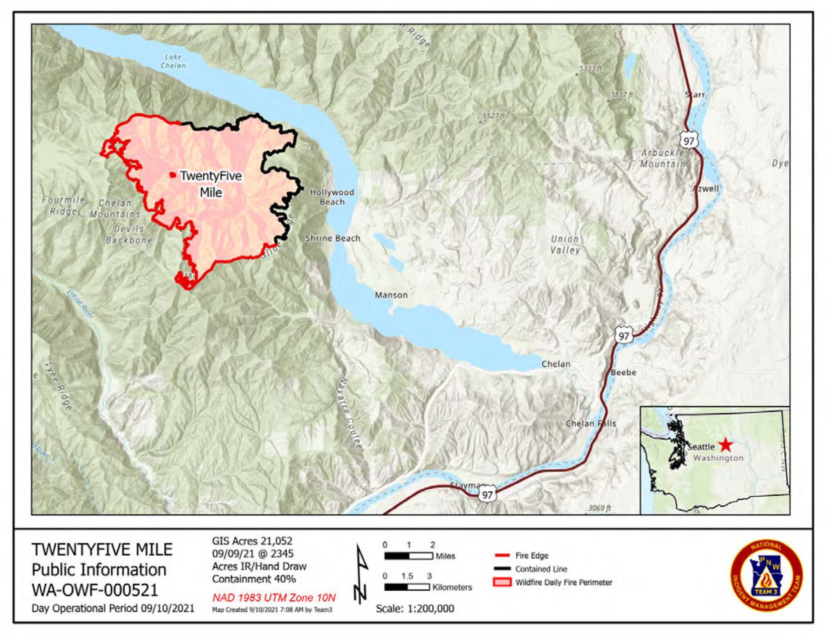
Twentyfive Mile Fire Update September 10
Related Incident:
Publication Type: News
Size: 21,052 acres
Total Personnel: 418
Containment: 40%
Location: 12 miles NW of Chelan, WA
Cause: Under investigation
Yesterday: Firefighters were able to take advantage of favorable conditions yesterday afternoon by continuing hand firing and aerial ignitions in the Stormy Mountain area. The primary objective of these burnout operations is to secure a line around the fire and limit the footprint of the fire to the area within that line. Air resources dropped retardant in strategic locations to “pre-treat” along the containment line in advance of firing operations. Further east and north, firefighters continued patrolling, mopping up, and securing the line where burnout operations were completed several days ago.
Today: As conditions allow, firefighters will continue burning operations to reinforce the containment line along the Devil’s Backbone northwest of Stormy Mountain. These firing operations are expected to continue for several days as they work northward along the Devils Backbone to near the Pot Peak and Devil’s Backbone Trail junction just south of Angle Peak. Firefighters will be burning out in strategic locations, removing vegetation between the containment line and the fire edge. This effectively reduces fire intensity before it reaches the containment lines, thereby reducing the potential for the fire spotting across containment lines. Firefighters will also be patrolling and mopping up where burnout operations were previously completed and structure protection crews will continue working in the Lake Chelan corridor south of Hollywood Beach, monitoring and maintaining the network of hoses, pumps, and other equipment placed in previous weeks. Road work is ongoing where needed to ensure safe access to the fire area for fire personnel.
Community Meeting: A recording of yesterday’s virtual community meeting for the Twenty-five Mile Fire can be viewed on Facebook(facebook.com/25MileFire2021) or the Twenty-five Mile Fire You Tube channel: https://youtu.be/mX6R8CijUV0.
Weather and Fire Behavior: Today will be mostly cloudy and there is a chance of light precipitation over the fire area, however this is not expected to be a wetting rain. A trend towards cooler temperatures with higher humidity will continue into the weekend. There is potential for hazy and smoky conditions in valley bottoms and along Lake Chelan and the Columbia River if burnout operations resume today.
Evacuations: Level 1 (Be Ready): All properties along South Lakeshore Road (from just north of Lake Chelan State Park to the end of the roadway), First Creek Road and Granite Falls Road. A map of current evacuation levels is available at: bit.ly/2WhU9Nu and additional information is available from Chelan County Emergency Management (facebook.com/ccsoem/).
Closures: The Okanogan-Wenatchee National Forest expanded the emergency fire closure for the Twenty-five Mile Fire on September 8. This closure is needed to provide for public and firefighter safety. Please check the interactive map of emergency closures when planning an outing: tinyurl.com/25mileforest.
Twentyfive Mile Fire Closure Order No 0617022128
Related Incident:
Publication Type: Closures
UNITED STATES DEPARTMENT OF AGRICULTURE
FOREST SERVICE
OKANOGAN-WENATCHEE NATIONAL FOREST
CHELAN, WA
TWENTYFIVE MILE FIRE
CLOSURE ORDER NO. 06-17-02-21-28
Pursuant to 16 USC § 551 and 36 CFR § 261.50(a) and (b), and to provide for public safety, the following acts are prohibited within the Chelan and Entiat Ranger Districts of the Okanogan-Wenatchee National Forest. This Order supersedes Order #06-17-02-21-19, signed on August 18, 2021 by Kristin M. Bail, and is effective September 8th, 2021 through December 31, 2021, unless rescinded earlier.
PROHIBITIONS:
1. Entering into or being upon National Forest System Lands, as described below and displayed on the attached map, Exhibit A [36 CFR § 261.53(e)].
2. Being on any National Forest System Road as described below and displayed on the attached map, Exhibit A [36 CFR § 261.54(e)].
3. Being on any National Forest System Trail, as described below and displayed on the attached map, Exhibit A [36 CFR § 261.55(a)].
FIRE EMERGENCY AREA CLOSURE DESCRIPTION:
The Fire Emergency Area Closure is defined as follows:
From the intersection of Forest Development Road (FDR) 5900 and FDR 5900-112 in Township 29 N, Range 19 East, Section 21 northwest along 5900-112 to intersection with the ridge separating Big Creek and Corral Creek in Township 29 N, Range 19 East, Section 8, following the ridge north to where it ends at Lake Chelan in Township 29 N, Range 19 East, Section 2, then west along the south shore of Lake Chelan to the intersection with the forest boundary approximately ½ mile past Fields Point in Township 29 N, Range 21 East, Section 33, south following the forest boundary to the intersection with the Johnson Creek Road in Township 27 N, Range 21 East, Section 29, north on the Johnson Creek Road (County Jurisdiction Road not closed) to where Johnson Creek turns into FDR 8410, continuing north on FDR 8410 to the junction with FDR 5380 in Township 27 N, Range 20 East, Section 22, north on the 8410 to the Stormy Mountain Trailhead, northwest on FS trail number 1448 to the intersection with FDR 5900 in Township 29 N, Range 19 East, Section PB41, west/northwest on the 5900 to the junction with the 5900-112.
In addition, the following roads and trails outside the area closure are closed: FDR 5900 from the junction with FDR 5100 to the junction with 5900-112. Trail 1443 from the junction with trail 1448 to the junction with trail 1445. Entire length of Trail 1444.
FIRE EMERGENCY ROAD CLOSURE DESCRIPTION
Road Number Description
535000 Entire length
537000 Entire length
5900 From junction with Forest Road 5100 to junction with South Lakeshore Drive
5900-112 Entire length, from junction with 5900 to the end
5900114 Entire length
5900115 Entire length
5900116 Entire length
5900118 Entire length
5900121 Entire length
5900124 Entire length
5900125 Entire length
5900126 Entire length
5900128 Entire length
5900130 Entire length
5900132 Entire length
5900221 Entire length
5900530 Entire length
5900535 Entire length
5903000 Entire length
5930100 Entire length
5903200 Entire length
5903400 Entire length
5905000 Entire length
8404000 Entire length
8410 From junction with Forest Road 5900 to junction with Johnson Creek (County Road)
8410100 Entire length
8410114 Entire length
8410119 Entire length
8410120 Entire length
8410125 Entire length
8410211 Entire length
8410231 Entire length
8410234 Entire length
8410237 Entire length
8410240 Entire length
8410300 Entire length
8410350 Entire length
8410410 Entire length
8410413 Entire length
8410510 Entire length
8410513 Entire length
8410515 Entire length
8500000 Entire length
8500207 Entire length
8500209 Entire length
8500211 Entire length
8500213 Entire length
8500214 Entire length
8500215 Entire length
8500217 Entire length
8500219 Entire length
8500221 Entire length
8500222 Entire length
8500223 Entire length
8500224 Entire length
8500225 Entire length
8500226 Entire length
8500308 Entire length
8500310 Entire length
8500311 Entire length
8500320 Entire length
8500326 Entire length
8500511 Entire length
8500513 Entire length
8500516 Entire length
8505000 From the forest boundary to where the road ends
8505100 Entire length
FIRE EMERGENCY TRAIL CLOSURE DESCRIPTION
1264 – Lone Peak Entire length
1265 – North Fork 25 Mile Creek Entire length
1266 – Pot Peak Entire length
1443 – Lake Creek From junction with 1445 north
1448 – Devils Backbone Entire length
1443 – Angle Peak Entire Length
1445 – Four Mile Ridge Entire Length See Exhibit A for closure map.
EXEMPTIONS:
Pursuant to 36 CFR § 261.50(e), the following persons are exempt from this Order:
1. Any Federal, State, or local officer, or member of an organized rescue or fire fighting force in the performance of an official duty.
2. Persons with Forest Service Permit No. FS-7700-48 (Permit for Use of Roads, Trails, or Areas Restricted by Regulation Order), specifically exempting them from this Order.
These prohibitions are in addition to the general prohibitions in 36 CFR Part 261, Subpart A.
Violations of this prohibition are punishable by a fine of not more than $5,000 for an individualor $10,000 for an organization, or imprisonment for not more than 6 months, or both (16 U.S.C. § 551; 18 U.S.C. §§ 3551, 3559, 3571, and 3581).
Executed in Wenatchee, Washington this 8th Day of September 2021.
KRISTIN M. BAIL
Forest Supervisor Okanogan-Wenatchee National Forest
Pronstico de Humo para 0909 1009
Related Incident:
Publication Type: News
Humo
Para hoy se espera que las condiciones del humo sean de nivel bueno a moderado alrededor del perímetro. Es posible que la zona de Chelan más cercana al incendio experimente un deterioro en la calidad de aire desde la mañana hasta que cambie la dirección de los vientos. Se pronostica flujo de aire del oeste al suroeste, lo que empujará el humo hacia el este y noreste del incendio. Las operaciones de quema y la actividad de otros incendios en la región pueden ser factores que influyan en el impacto del humo.
Emitido por USFS Wildland Fire Air Quality Response Program www.wildlandfiresmoke.net Central Washington Actualizaciones tools.airfire.org/outlooks/centralwashington *Información sobre humo y su salud https://www.cdc.gov/spa.../especialesCDC/IncendiosForestales
Emitido por USFS Wildland Fire Air Quality Response Program www.wildlandfiresmoke.net
Central Washington Actualizaciones tools.airfire.org/outlooks/centralwashington
nformación sobre humo y su salud https://www.cdc.gov/spa.../especialesCDC/IncendiosForestales
Actualizacin sobre el incendio de Twentyfive Mile 9 de septiembre de 2021
Related Incident:
Publication Type: News
Tamaño: 20,756 acres
Personal total: 422
Contención: 40%
Causa: A ser determinada
Reunión virtual comunitaria a las 4:00 p.m. sobre el incendio de Twenty-five Mile. La reunión será transmitida a través de facebook.com/25MileFire2021.
Ayer: A tempranas horas de la mañana, una pequeña perturbación meteorológica con vientos fuertes e irregulares provocó varios focos pequeños de incendio a lo largo de la línea de contención sureste del perímetro. Los bomberos actuaron rápido para contener los focos y mantenerlos a un tamaño igual o inferior a ¼ de acre. Durante el día, los equipos mantuvieron con éxito las líneas de contención y rasterizaron focos en los extremos sur y norte del incendio. La rasterización es un método que consiste en cruzar líneas paralelas con rutas fuera de la línea de fuego para buscar focos adicionales de incendio. Los equipos en la zona de Twenty-five Mile continuaron desinstalando y retirando maquinaria, incluyendo las nueve millas de mangueras que fueron instaladas para la protección de estructuras. Esta operación se encuentra en curso desde el norte al sur del corredor del lago Chelan.
Hoy: Los bomberos subirán a la zona de Devils Backbone para trabajar desde campamentos alejados donde tendrán una mejor ubicación para continuar las operaciones de quema manual. Cuando las condiciones lo permitan, se comenzarán las operaciones de quema desde el noroeste de Stormy Mountain hacia Angle Peak. Los bomberos seguirán patrullando la línea donde se realizaron previas operaciones de quema, y limpiarán y controlarán las líneas de contención donde sea necesario. Mientras que se retiran los equipos al norte de Hollywood Beach, al sur, la desinstalación y retiro de sistemas de protección de estructuras no comenzará hasta que los oficiales del incendio consideren que las líneas de contención al sur están seguras. Los equipos de protección de estructuras seguirán monitoreando el área alrededor de residencias en las cuencas de First y Granite Falls.
Condiciones meteorológicas y comportamiento del incendio: La nubosidad aumentará a medida que transcurre el día, y se esperan ráfagas de viento en las cimas de las laderas que pueden alcanzar los 20-22 mph tarde. Los grandes escombros carburantes permanecen muy secos y, esto, combinado con los fuertes vientos, puede aumentar la intensidad del incendio. El humo del incendio seguirá siendo visible desde Chelan y las zonas cercanas.
Evacuaciones: Nivel 1 (Estar preparado): Todas las propiedades a lo largo de South Lakeshore Road (desde el norte del parque estatal Lake Chelan hasta el final de la vía), First Creek Road y Granite Falls Road. Puede encontrar un mapa disponible con los actuales niveles de evacuación en: bit.ly/2WhU9Nu , así como más información adicional del Departamento de gestión de emergencias del condado de Chelan (facebook.com/ccsoem/).
Cierres: Algunos de los terrenos del sistema de bosques nacionales cercanos al incendio de Twenty-five Mile Creek se encuentran cerrados. Los cierres se establecen para ofrecer seguridad a los bomberos y al público. Consulte el mapa interactivo de cierres de emergencia cuando planifique salir: tinyurl.com/25mileforest.
Why are burn out operations on Stormy Mountain necessary
Related Incident:
Publication Type: News
Burn out operations are being used on the Twenty-five Mile Fire to strengthen indirect containment lines from Slide Peak to Stormy Mountain. These strategic firing operations will continue along the Devils Backbone to near the Pot Peak and Devil’s Backbone Trail junction just south of Angle Peak.
Indirect containment lines were constructed some distance from the fire edge to allow time for completing the line construction and to take advantage of natural features like Slide Ridge and Devils Backbone where firefighters have a greater chance of stopping the fire.
In the face of fire rapidly moving uphill, pushed by wind, spotting at distances of one tenth of a mile or more, or in situations where dense vegetation is directly adjacent to the indirect containment line, a line on the ground, even one the width of a dozer line, is not enough. Fire will easily compromise lines when there are mixed conifer trees, subalpine fir and overcrowded vegetation directly adjacent. All of these conditions exist along containment lines on the Twenty-five Mile Fire. To add depth, firefighters have been conducting strategic burning operations.
Burn out operations along indirect containment lines are employed to remove unburned vegetation between the containment line and the fire edge. This effectively reduces fire intensity before it reaches the containment lines thereby reducing the potential for the fire spotting across containment lines. The combination of strategically placed containment lines and burn out operations is an effective tactic for stopping fire spread.
Burn out operations in the Slide Ridge area are necessary to prevent the fire from moving into the First Creek drainage and the Entiat Valley where it could impact private property and residences. Smoke columns and fire glow after dark will continue to be visible from Chelan, Manson and the surrounding areas during these operations.