
Evacuation Status Changes for Sierra County 06072022
Related Incident:
Publication Type: Announcement
FOR IMMEDIATE RELEASE FROM SIERRA COUNTY SHERIFF'S OFFICE
Sierra County, NM - June 5, 2022: The Sierra County Sheriff’s Office in close coordination with the Southwest Incident Management Team 3 is making changes to evacuation status for the Black Fire.
A decision to make immediate changes to the current evacuation status was made after a review of fire personnel activity in and around areas north of Kingston and Percha Creek. After considering several factors to include fire behavior, fuel types, natural barriers, estimated time of evacuation, and other factors, it was determined that the residents within these communities should begin or continue efforts to safeguard their homes and properties from the risks associated with the Black Fire and should be upgraded from “PLANNING” to a “READY” status.
Evacuations will upgrade from PLANNING to READY for the following areas
KINGSTON/PERCHA CREEK- RESIDENTS AND PROPERTY OWNERS IN KINGSTON AND PERCHA CREEK AREAS
Areas 1A, 2A (West of Chloride/Winston), 4, 8A and 11A remain in GO status. These changes are effective immediately. Please continue to stay vigilant and aware of fire activity.
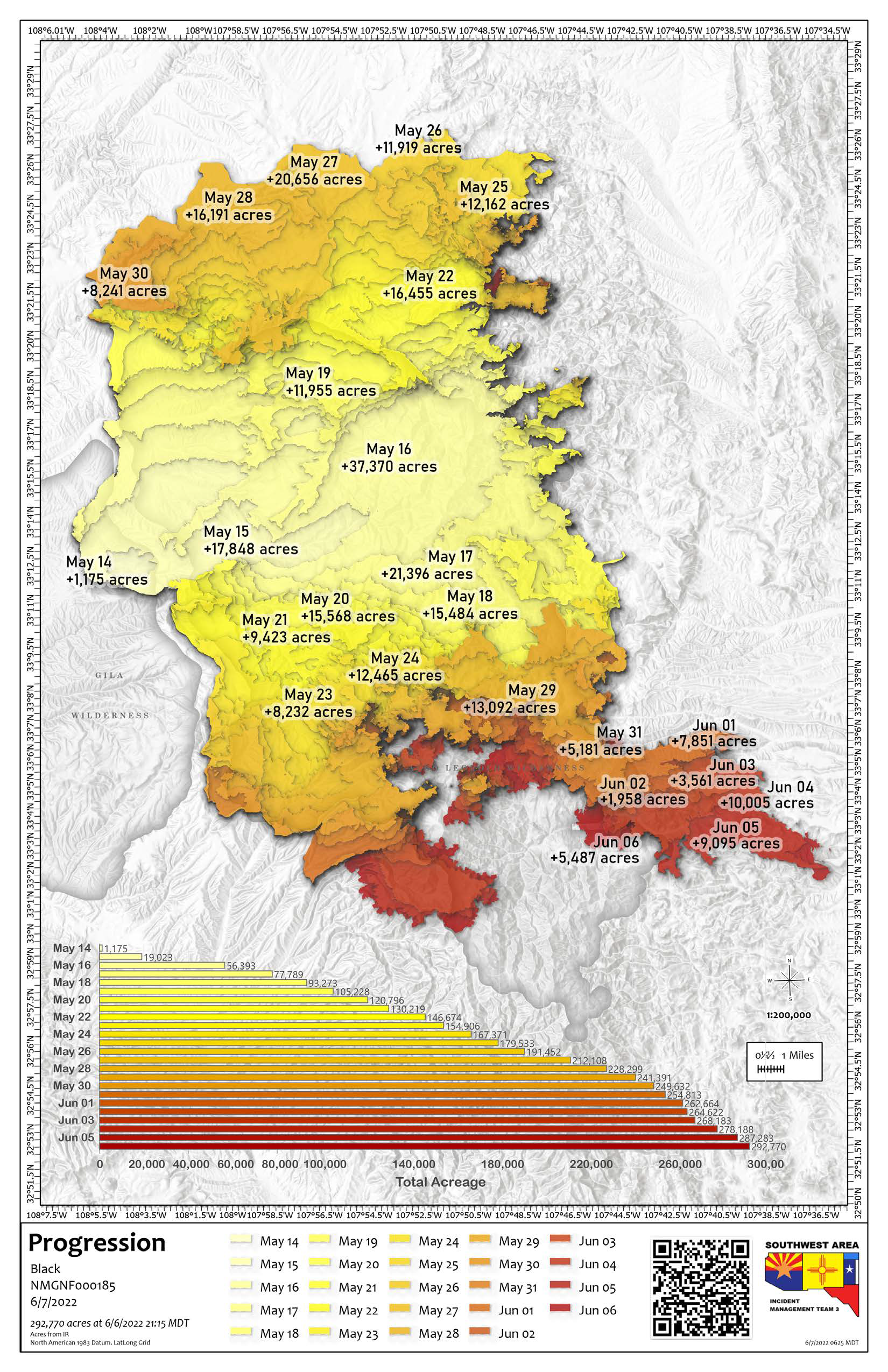
Black Fire Daily Update June 7 2022
Related Incident:
Publication Type: News
Firefighters Continue to Work Around the Clock to Fully Suppress the Black Fire / New Road Closures
Acres: 292,770 acres
Location: 31 miles NW of Truth or Consequences
Containment: 49%
Personnel: 893
Start Date: Friday, May 13, 2022
Cause: Human-caused, under investigation
Fuels: Timber and tall grass
Structures Lost: 2
New Road Closures: New Mexico Highway 59 will remain closed to traffic from Forest Road 150 to New Mexico Highway 52 between the hours of 8:00 a.m. to 6:00 p.m. to provide safety for firefighters working along the roadway. The New Mexico Highway 59 will be open to traffic between the hours of 6:00 p.m. to 8:00 a.m. A portion of the Gila National Forest affected by the fire has been closed.
To learn about the current evacuation status for the Black Fire, please access the real-time, interactive evacuation map or contact your local jurisdiction’s emergency management agencies.
The fire management strategy for the Black Fire is 100% full suppression. Firefighters are creating fire line by hand and using bulldozers while air resources drop water on the fire. Water drops are delay tactics to cool the temperature of the fire to allow firefighters to work along the fire’s edge. Firefighters are also doing structure protection, which includes reducing vegetation around structures and setting up sprinkler systems; in the event these are needed. Firefighters continue to work during the nighttime near the most active part of the fire in the East Mimbres Valley and Las Animas areas. In addition to the above activities, aircraft is being used for recon missions and aerial ignitions to remove fuels to slow the progression of the fire. The contained portions of the fire will be monitored and patrolled by firefighters on the ground and in the air. There is a lot of fire traffic around the entire fire area, so please be cautious when driving in these areas.
Weather: Dry weather with hot temperatures will prevail over the fire today, with relative humidity falling into the low teens to single digits. The winds will continue to be breezy out of the southwest, with poor overnight humidity recoveries. The winds will become more terrain driven on Wednesday as high pressure moves into the region.
Aviation Restrictions: A Temporary Flight Restriction (TFR) over the Black Fire restricts non-fire aircraft. This includes civilian drones. Unauthorized aircraft in the area can ground firefighting aircraft, hinder firefighting efforts, and can also result in criminal charges for the offender.
Fire Restrictions: Know Before You Go! The public can obtain current state and federal fire restriction information across New Mexico at NM Fire Info | Fire Restrictions or at NM Forestry Division state-wide fire restrictions
More Information:
Black Fire Daily Update June 6 2022
Related Incident:
Publication Type: News
Containment Increases on the Northeast Side of the Black Fire / Community Meeting Tonight at 6 p.m.
Acres: 287,273 acres
Location: 31 miles NW of Truth or Consequences
Containment: 49%
Personnel: 833
Start Date: Friday, May 13, 2022
Cause: Human-caused, under investigation
Fuels: Timber and tall grass
Structures Lost: 2
To learn about the current evacuation status for the Black Fire, please access the real-time, interactive evacuation map or contact your local jurisdiction’s emergency management agencies.
Community Meeting Tonight at 6 p.m. in Mimbres: Camp Thunderbird, 3951 Hwy 35, Mimbres, (mile marker 13.5).
Firefighter’s hard work around the clock has resulted in increased containment on the northeast and northwest corners of the Black Fire. The most active part of the fire remains along the southeastern edge near Round Mountain and McKnight Canyon. Firefighters are actively working along the fire’s edge near Round Mountain, Dunn Place, Apache Peak, and the Seco Creek drainages. A Hotshot crew hiked into the Rabb Park area to build hand line along the trail system. Firefighters have placed aluminum wrap on the Wright’s, Noon Day cabins, and Hillsboro Peak Lookout to protect these structures. The McKnight cabin was not damaged by the fire activity Sunday. Fire suppression repair chipping activities continue along the existing containment lines.
More firefighters are working in the Kingston area and a temporary fire spike camp has been established in Kingston. Therefore, fire traffic has increased along Highway 152, so please use extra caution if driving in this area.
Weather: Dry weather and warmer temperatures will prevail over the fire today, with relative humidity falling into the mid to single digits. The winds will continue to be out of the southwest, with a few gusts up to 30 mph. There will continue to be poor overnight relative humidity recoveries.
Closures: Highway 59 is closed from Mud Hole to the 59/150 intersection. Forest Road 150 is also closed at the North Star Helispot. I-25 and other state highways remain open. A portion of the Gila National Forest affected by the fire has been closed.
Aviation Restrictions: A Temporary Flight Restriction (TFR) over the Black Fire restricts non-fire aircraft. This includes civilian drones. Unauthorized aircraft in the area can ground firefighting aircraft, hinder firefighting efforts, and can also result in criminal charges for the offender.
Fire Restrictions: Know Before You Go! The public can obtain current state and federal fire restriction information across New Mexico at NM Fire Info | Fire Restrictions or at NM Forestry Division state-wide fire restrictions
More Information:
Evacuation Status Changes For Sierra County 06062022
Related Incident:
Publication Type: Announcement
FOR IMMEDIATE RELEASE FROM SIERRA COUNTY SHERIFF'S OFFICE
Sierra County, NM - June 6, 2022: The Sierra County Sheriff’s Office in close coordination with the Southwest Incident Management Team 3 is making changes to evacuation status for the Black Fire.A decision to make immediate changes to the current evacuation status was made after a review of fire activity in and around areas affected near the Ladder Ranch. After considering several factors to include fire behavior, fuel types, natural barriers, estimated time of evacuation, and other factors, it was determined that the residents and employees of the Ladder Ranch, are currently in increased danger from the Black Fire and should be upgraded from a “SET”to a “GO” status.
Evacuations will upgrade from SET to GO for the following areas:
UPPER ANIMAS CREEK AREA- LADDER RANCH
Areas 1 A, 2A, 4, 8A and 11A remain in GO status. These changes are effective immediately. Please continue to stay vigilante and aware of fire activity.
More information about “Ready, Set, Go”
Real time, interactive evacuation map visit
Black Fire Evacuation Status Changes for Sierra County 06052022
Related Incident:
Publication Type: News
BLACK FIRE EVACUATION STATUS CHANGES FOR IMMEDIATE RELEASE
Sierra County, NM - June 5, 2022: The Sierra County Sheriff’s Office in close coordination with the Southwest Incident Management Team 3 is making changes to evacuation status for the Black Fire.
A decision to make immediate changes to the current evacuation status was made after a review of fire activity in and around areas affected at the northeast and eastern boundaries of the Black Fire. After considering several factors to include fire behavior, fuel types, natural barriers, estimated time of evacuation, and other factors, it was determined that area 1A the small polygon within area 3 at the fire’s northeast edge along Bear Creek Rd., south along the fires east edge to the containment line west of Way-Up Mountain, was no longer currently in imminent danger from the Black Fire and should be downgraded from “GO” to a “SET” status.
This continued decrease in fire activity along the northeast and east fire edge line prompted area 3 from Winston/Chloride to south of Montosa Mountain to be downgraded from “SET” to a “READY” status.
Evacuations will downgrade from GO to SET for the following areas:
AREA 1A- BEAR CREEK ROAD @ NORTHEAST FIRE’S FOOTPRINT TO AREA 3 EAST OF LOOKOUT MOUNTAIN. EAST OF LOOKOUT MOUNTAIN ALONG THE FIRE’S EDGE SOUTH TO THE CONTAINMENT LINE WEST OF WAY-UP MOUNTAIN.
Evacuations will downgrade from SET to READY for the following areas:
AREA 3- BEAR CREEK ROAD SOUTH TO BRUSHY MOUNTAIN TO INCLUDE THE WINSTON AND CHLORIDE AREAS
Areas 4 (Hermosa south), 8A and 11A remain in GO status. These changes are effective immediately. Please continue to stay vigilante and aware of fire activity. For information about “Ready, Set, Go” visit: https://www.emnrd.nm.gov/sfd/fire-prevention-programs/.
See a real time, interactive evacuation map
Black Fire Evacuation Status Changes for Catron County 06052022
Related Incident:
Publication Type: Announcement
For Immediate Release from Catron County Sheriff’s Office
Change in Black Fire evacuation status Per USFS and Catron County Sheriff’s Office
Effective June 5, 2022, the following changes in the evacuation status pertaining to the Black Fire in Catron County will be as follows
Unit #1B area within Catron County will change from a Go status to a READY status. This area is the Southeast corner of Catron County that is within the Black Fire burn area. The area extends from the Catron / Sierra County Line west to the Beaverhead area
NM Hwy 59 will remain closed to traffic from Forest Road 150 to NM Hwy 52 between the hours of 8:00 AM to 6:00 PM for the safety of fire crews working along the roadway. The Highway will be open to traffic between the hours of 6:00 PM to 8:00 AM
These areas will remain being monitored and subject to being change should the need arise
For further inquiries please contact the Catron County Sheriff’s Office
(575) 533-6222
Sheriff Keith Hughes
Catron County Sheriff’s Office
Black Fire Public Meeting Monday June 6th 2022
Related Incident:
Publication Type: Announcement
There will be a public meeting for the Black Fire on Monday, June 6th 2022 at 6pm. It will be held at Camp Thunderbird, 3951 Hwy 35, Mimbres, (mile marker 13.5)
Please note that the meeting will be outside. If you would like to sit during the meeting, please bring your own chair.
Black Fire Daily Update June 5 2022
Related Incident:
Publication Type: News
Black Fire Produces Huge Smoke Plume Yesterday due to Heavy Fuels Burning in the Board Gate Saddle Area
Acres: 278,188 acres
Location: 31 miles NW of Truth or Consequences
Containment: 27%
Personnel: 883
Start Date: Friday, May 13, 2022
Cause: Human-caused, under investigation
Fuels: Timber and tall grass
Structures Lost: 2
To learn about the current evacuation status for the Black Fire, please access the real-time, interactive evacuation map or contact your local jurisdiction’s emergency management agencies.
Yesterday, the Black Fire produced a large smoke plume due to heavy fuels burning in the Board Gate Saddle area in the McKnight Canyon, which was anticipated by fire managers. The fire also crossed Las Animas Creek near the Round Mountain and Dunn place too. These two areas were the most active parts of the fire.
Firefighters are working day and night shifts, using direct (creating hand line against the fire’s edge) and indirect (building fire line using existing roads and bulldozers) tactics to fully suppress the fire. No fire growth has been reported in the Turkey and Bear Creek areas for the past few days and these areas will be monitored and patrolled. Firefighters continue using chipping operations and removing burnt trees along the existing containment lines. Air operations will be used as necessary to assist firefighters on the ground as weather conditions allow.
The Southwest typical fire season conditions of hot temperatures, high winds, low humidity levels, and rugged terrain are barriers to fighting this fire. All efforts are being used to fully suppress the fire while ensuring firefighter and public safety remains our top priority.
Weather: Dry weather and warmer temperatures will prevail over the fire today, with relative humidity falling into the mid to single digits. The winds will continue to be out of the southwest this afternoon, with a few gusts up to 30 mph. There will continue to be poor overnight relative humidity recoveries.
Closures: Highway 59 is closed from Mud Hole to the 59/150 intersection. Forest Road 150 is also closed at the North Star Helispot. I-25 and other state highways remain open. A portion of the Gila National Forest affected by the fire has been closed.
Aviation Restrictions: A Temporary Flight Restriction (TFR) over the Black Fire restricts non-fire aircraft. This includes civilian drones. Unauthorized aircraft in the area can ground firefighting aircraft, hinder firefighting efforts, and can also result in criminal charges for the offender.
Fire Restrictions: Know Before You Go! The public can obtain current state and federal fire restriction information across New Mexico at NM Fire Info | Fire Restrictions or at NM Forestry Division state-wide fire restrictions
More Information:
Black Fire Evacuations Status Changes for Sierra County morning 06052022
Related Incident:
Publication Type: Announcement
FOR IMMEDIATE RELEASE FROM THE SIERRA COUNTY SHERIFF'S DEPARTMENT
Sierra County, NM - June 5, 2022: The Sierra County Sheriff’s Office in close coordination with the Southwest Incident Management
Team 3 is making changes to evacuation status for the Black Fire. A decision to make immediate changes to the current evacuation status was made after a review of fire activity in and around areas affected near the Ladder Ranch. After considering several factors to include fire behavior, fuel types, natural barriers, estimated time of evacuation, and other factors, it was determined that the residents and employees of the Ladder Ranch, are currently in increased danger from the Black Fire and should be upgraded from a “READY” to a “SET” status.
Evacuations will upgrade from READY to SET for the following areas:
UPPER ANIMAS CREEK AREA- LADDER RANCH
Areas 1A, 3 (NW of Chloride/Winston), 4, 8A and 11A remain in GO status. These changes are effective immediately. Please continue to stay vigilant and aware of fire activity.
Gila National Forest Expanded Closure Order Beginning 0606
Related Incident:
Publication Type: Closures
Effective Monday, June 6th at 12:00pm MT
PROHIBITIONS:
Pursuant to 16 U.S.C. § 551 and 36 C.F.R. § 261.50(a) and (b), the following acts are prohibited within the area and on the roads described in this Order (the “Restricted Area”), and as depicted on the attached map, hereby incorporated into this Order as Exhibit A, all within the Wilderness and Black Range Ranger Districts, Gila National Forest, Catron, Sierra and Grant Counties within the State of New Mexico:
- Going into or being upon the Restricted Area. 36 C.F.R. § 261.53(e).
- Being on the road. 36 C.F.R. § 261.54(e).
- Being on a trail. 36 CFR § 261.55(a).
Pursuant to 36 C.F.R. § 261.50(e), the following persons are exempt from this Order:
- Persons with a written Forest Service authorization specifically exempting them from the effect of this Order.
- Any Federal, State, or local officer, or member of an organized rescue or fire fighting force in the performance of an official duty.
- Owners or lessees of land in the area for the sole purpose of access to their private lands and/or residences
AREA AND ROADS DESCRIBED
As depicted on the map at Exhibit A, the Restricted area consists of all National Forest System lands. Beginning at the intersection of Forest Road 150 (North Star Road) and New Mexico State Highway 59 (east of Beaverhead). Progressing east along State Highway 59 to the intersection of Forest Road 955. Northeast along Forest Road 955 to the intersection of Forest Road 584, continuing north and northeast along Forest Road 584 to the intersection of Forest Road 4052B, then east along Forest Road 4052B to the forest boundary. Following the forest boundary south then east, continuing north along the forest boundary to the intersection of Forest Road 4141. East on Forest Road 4141 to its intersection with Forest Road 4052S to where it intersects with the Continental Divide trail. Continuing East along the Continental Divide Trail to the intersection of Forest Trail 60 (Duck Canyon), east along trail 60 (Duck Canyon) to the eastern boundary of the Gila National Forest. Following the Forest Boundary south for approximately 44 miles to State Highway 152 (east of Kingston). West along State Highway 152 for approximately 11(air miles) to where State Highway 152 intersects with the Forest Boundary south of Hendricks Peak. Continuing west along the Forest Boundary to its intersection with State Highway 35. Continuing northwest along State Highway 35 to the intersection of Forest Road 4079T (Lincoln Canyon), Then northeast along Forest Road 4079T to its intersection with Forest Trail 965 and Forest Road 4079R. East along Forest Trail 965 becoming Forest Road 4079R to the intersection with Forest Road 150 (North Star Road). Progressing north on Forest Road 150 to the intersection of Forest Trail 700 (Brannon Park) which intersects with Forest Trail 74 (Continental Divide Trail). West along the Continental Divide Trail to the intersection of Forest Trail 95 (Big Timber). Then northwest on Forest Trail 95 to its intersection with Apache Creek (drainage). West along Apache Creek to the intersection of Black Canyon Creek (drainage). Northwest along Black Canyon Creek to the intersection of Forest Trail 708 (Tom Moore). Northeast along Forest Trail 708 which intersects with Forest Trail 713 (Link). Northeast along Forest Trail 713 to the intersection with Forest Road 609. Forest Road 609 east to the intersection of Forest Road 150. North along Forest Road 150 back to its beginning at the intersection of Forest Road 150 and Highway 59 (East of Beaverhead).
The following roads are closed: Forest Road 150 is closed from Highway 35 north approximately 45 miles to its intersection with State Highway 59. State Highway 59 is closed from the intersection of Forest Road 150 to the intersection of State Highway 52 (approximately 25 miles). All roads and trails within the area depicted as “Restricted Area” are closed, including the portions of the Continental Divide Trail.
The following developed campgrounds are closed Upper Black Canyon, Lower Black Canyon, Rocky Canyon, Lower Gallinas, Upper Gallinas, Railroad Canyon, Iron Creek and Kingston.
The closure also includes Emory Pass Vista and Wrights Cabin.
PURPOSE
To protect public health and safety during the Black Fire suppression activities.
IMPLEMENTATION
- This Order will be effective on the 6th of June 2022, at 1200, and will remain in effect until December 31st, 2022, or until rescinded, whichever occurs first.
- A Map identifying the area closure is attached and made part of this Order as Exhibit A. For a digital version of the Order map for the NF, go to https://www.fs.usda.gov/alerts/gila/alerts-notices
- Any violation of this prohibition is punishable by a fine of not more than $5,000 for individuals and $10,000.00 for organizations and/or imprisonment for not more than six (6) months (see 16 U.S.C. § 551, 18 U.S.C. § 3571(b)(6), 18 U.S.C. § 3581 (b)(7)).
- Further information regarding this Order may be obtained at the Gila National Forest Supervisors office located in Silver City, NM, telephone number 575-388-8201
- This Order supersedes any previous orders prohibiting the same act covered by this Order.