
Black Fire Daily Update Wednesday June 22
Related Incident:
Publication Type: News
SOUTHWEST AREA
INCIDENTMANAGEMENT TEAM
TEAM4–AARONHULBURD –INCIDENTCOMMANDER
Suppression repair continues despite rains on the Black Fire
June 22, 2022 Daily Update
Acres: 325,128 acres
Containment: 68%
Total Personnel: 835
Cause: Human-caused, under investigation
Start Date: Friday, May 13, 2022
Location: 31 miles NW of Truth or Consequences, NM
Fuels: Timber and tall grass
Highlights: Firefighters on the Black Fire are working diligently through wind and rain on fire suppression repair efforts. Fire suppression repair involves a series of immediate post-fire actions taken to repair damages and minimize potential soil erosion and impacts resulting from fire suppression activities. Suppression repair typically begins before the fire is fully contained. This work involves repairing hand and dozer lines, roads, trails, staging areas, safety zones, and drop points used during fire suppression efforts. Suppression repair by the Incident Management Team is an initial effort at reducing adverse impacts and is separate from Burned Area Emergency Response (BAER) and Burned Area Repair (BAR) efforts.
Operations: Minimal fire activity occurred yesterday in the southwest portion of the fire near Water Canyon as thunderstorms developed and passed over the Black Fire. A hotshot crew was sent into Water Canyon to construct additional fire line around the Forest Service cabin. Once the line was completed, the crew sought out and extinguished any remaining hotspots. More equipment will be brought into the western side of the fire area today to help repair fire lines and chip residual vegetation. On the northern fire perimeter, grader work is almost complete with a small portion remaining on the Titanic Road. Crews are scouting on foot and by air to identify repair needs on the eastern perimeter. Chippers are moving into this area for additional chipping and scattering of vegetation. With support from the helicopter crew, crews plan to backhaul hose and sprinkler equipment from the Forest Service Lodge. In North Percha, firefighters are finishing a small amount of hand line repair and dozer work. As the fire is winding down, firefighters are being released to return home to rest and prepare for their next fire assignment.
Weather: Deep monsoon moisture remains in place today, with the potential for some thunderstorms to produce heavy rainfall. Mostly cloudy skies, cool daytime temperatures, and high humidity levels will occur into Thursday morning. Less moisture on Thursday into the weekend will result in warmer temperatures, lower humidity, and reduced thunderstorm coverage.
Evacuations: All evacuations and evacuation preparedness levels have been lifted for communities in Sierra, Grant, and Catron Counties. The real-time, interactive evacuation map has been revised to reflect this change.
Closures: The Black Fire Emergency Closure remains in effect on National Forest System lands around the Black Fire area. Additional information is available at: https://www.fs.usda.gov/alerts/gila/alerts-notices/?aid=73435. Highway 152 remains open from milepost 40 (Kingston) to milepost 15 (San Lorenzo). Please continue to use caution in the area and be mindful of increased fire traffic.
Restrictions: Know Before You Go! The public can obtain current state and federal fire restriction information across New Mexico at NMFire Info | Fire Restrictions or NM Forestry Division state-wide fire restrictions.
Safety: The health and safety of firefighters and the public is always the top priority. Members of the public should stay away from Black Fire operations. A Temporary Flight Restriction is in place over the Black Fire area, which includes unmanned aircraft, or drones. More information on the dangers drones pose to wildland firefighting aircraft and personnel on the ground can be found at: https://uas.nifc.gov/.
Information: Due to reduced fire activity, daily updates and maps will no longer be posted on information boards located in areas to the west and north of the Black Fire.
Fire updates are posted on InciWeb, the Gila National Forest Facebook and Twitter pages, and NM Fire Information.
Email:2022.black@firenet.gov• Phone: (575)-249-1264 • Office Hours: 8:00 AM – 8:00 PM
Actualizacin diaria del 21 de junio de 2022
Related Incident:
Publication Type: News
EQUIPO DE GESTIÓN DE
INCIDENTES DEL ÁREA DEL SUROESTE
EQUÍPO 4 – AARON HULBURD – COMANDANTE DEL INCIDENTE
Se ha levantado el estado de evacuación sobre el incendio Black
Actualización diaria del 21 de junio de 2022
Acres: 325,115 acres
Contención: 68%
Personal total: 943
Causa: de orígen human, a ser determinada
Fecha de inicio: Viernes 13 de mayo de 2022
Ubicación: 31 millas al noroeste de Truth or Consequences, NM
Combustibles: Coníferas mixtas y hierbas altas
Puntos importantes: las condiciones del incendio han mejorado como resultado de las lluvias recientes y por eso se ha reducido la amenaza inmediata para las comunidades que rodean el incendio Black. Se han levantado todas las evacuaciones y los niveles de preparación para evacuación para las comunidades de los condados Sierra, Grant y Catron. El mapa de evacuación interactivo en tiempo real se ha revisado para reflejar este cambio.
Aunque ha disminuído la amenaza inmediata del incendio, se anima a los residentes a continuar monitoreando los pronósticos meteorológicos y la posibilidad de inundaciones posteriores al incendio en https://www.weather.gov/epz/, así como los sitios web de gestión de emergencias para los condados Sierra, Catron y Grant.
Los pronósticos meteorológicos actuales señalan a una mayor probabilidad de tormentas monzónicas severas y por eso los residentes deben tomar precauciones ya que el aumento de la escorrentía del áreas quemada pudiera representar amenazas adicionales de inundaciones.
La carretera New Mexico 152 ya está abierta desde el marcador de millas 40 (Kingston) hasta el marcador de millas 15 (San Lorenzo). Por favor, siga practicando precaución en el área y tenga en cuenta el aumento del tráfico de bomberos.
Operaciones: los bomberos están realizando vuelos de reconocimiento rutinarios para seguir recopilando información del fuego y las necesidades de reparación de extinción que existen dentro del incendio Black. Con estos vuelos los equipos vieron que el fuego se desplaza lentamente entre agujas de pino tiradas en el suelo del bosque en Water Canyon. Enseguida los bomberos extinguieron el área pequeña de medio acre e hicieron una línea de mano para proteger la cabina del Servicio Forestal que está cerca. Los bomberos continuarán vigilando y sosteniendo este cortafuego en Water Canyon para que el fuego no se propague. También se observó en el extremo sur alguna actividad de fuego en Hillsboro Peak. Las cuadrillas tienen planes de vigilar esta zona para asegurarse de que la actividad no empeore cuando las temperaturas comiencen a subir. No se vio ninguna actividad de fuego en Granite Peak. Las áreas en el centro y el este del incendio han recibido 1-2 pulgadas de lluvia, lo que obligó a algunos equipos de reparación a que cesaran el trabajo y abandonaran la zona debido a las inundaciones. Según sea necesario, los bomberos están removiendo el equipo de extinción, que incluye mangueras, rociadores y grandes tanques de agua conocidos como "Pumpkins” dentro y alrededor del borde del incendio. Las cuadrillas están dispersando vegetación cortada sobre las líneas de mano y topadoras para ayudar a prevenir la erosión de las lluvias que se esperan.
Clima: una alerta de inundación repentina está vigente desde el día de hoy hasta las 6:00 de la mañana el miércoles. La humedad profunda del monzón provocará numerosas lluvias y tormentas eléctricas hasta el miércoles, con la posibilidad de fuertes lluvias e inundaciones repentinas dentro y alrededor del área quemada. Durante este tiempo se verán cielos mayormente nublados, temperaturas más frías y mayor humedad. Para el final de la semana se verá menos humedad por causa de las temperaturas más cálidas, y una cobertura reducida de tormentas eléctricas.
Restricciones:¡Infórmese antes de salir! El público puede obtener información estatal y federal actualizada sobre las restricciones de incendios en Nuevo México en Información sobre incendios en NM| Restricciones de incendios o en la división forestal de NM Restricciones de incendios en todo el estado.
Seguridad: la prioridad más alta siempre es la salud y la seguridad de los bomberos y el público. El público debe mantenerse alejado de las operaciones del incendio Black. Una restricción temporaral de vuelo esta vigente sobre el área del incendio Black, que incluye aviones no tripulados o drones. Puede encontrar más información sobre los peligros que los drones representan para las aeronaves de extinción de incendios forestales y el personal terrestre en: https://www.nifc.gov/.
Humo: el humo ahora es menos visible ya que las tormentas de lluvia han entrado al área del incendio Black. Un mapa interactivo de humo en https://fire.airnow.gov/ le permite hacer zoom en su área para ver las últimas condiciones de humo. Para obtener información adicional, consulte el Informe de humo del incendio Black.
Se publican las actualizaciones de incendios en InciWeb, las páginas de Facebook y Twitter del Bosque Nacional Gila, e Información sobre los incendios en NM.
Correo electrónico: 2022.black@firenet.gov • Teléfono: (575)-249-1264 • Horario de oficina: 8:00 AM – 8:00 PM
Black Fire Update Tuesday June 21
Related Incident:
Publication Type: News
SOUTHWEST AREA
INCIDENTMANAGEMENT TEAM
TEAM4–AARONHULBURD –INCIDENTCOMMANDER
Evacuation status lifted on the Black Fire
June 21, 2022 Daily Update
Acres: 325,115 acres
Containment: 68%
Total Personnel: 943
Cause: Human-caused, under investigation
Start Date: Friday, May 13, 2022
Location: 31 miles NW of Truth or Consequences, NM
Fuels: Timber and tall grass
Highlights: Due to recent rainfall and improved fire conditions, the immediate threat to communities surrounding the Black Fire has been reduced. All evacuations and evacuation preparedness levels have been lifted for communities in Sierra, Grant, and Catron Counties. The real-time, interactive evacuation map has been revised to reflect this change.
While the immediate threat from the fire has decreased, residents are encouraged to continue to monitor weather forecasts and post-fire flooding potential at https://www.weather.gov/epz/, as well as Emergency Management websites for Sierra County,Catron County, and Grant County.
Current weather forecasts indicate a high probability of severe monsoon storms and residents should take precautions as increased runoff from the burned area may pose additional threats for flooding.
The Black Fire Emergency Closure remains in effect on National Forest System lands around the Black Fire area. Additional information is available at: https://www.fs.usda.gov/alerts/gila/alerts-notices/?aid=73435.
New Mexico Highway 152 is now open from milepost 40 (Kingston) to milepost 15 (San Lorenzo). Please continue to use caution in the area and be mindful of increased fire traffic.
Operations: Firefighters are performing routine reconnaissance flights to continuously gather information on fire activity and suppression repair needs within the Black Fire. During these flights, crews observed fire slowly moving through pine needles on the forest floor in Water Canyon. Firefighters proceeded to suppress the small half-acre area, constructing handline to protect the nearby Forest Service cabin. Firefighters will continue to monitor and hold this fireline in Water Canyon to prevent further fire spread. Some fire activity was also observed at Hillsboro Peak on the southern end. Crews plan to monitor this area to ensure activity does not increase when temperatures start to rise. No fire activity was observed on Granite Peak. The central and eastern areas of the fire have received 1-2 inches of rain, forcing some repair crews to cease operations and leave the area due to flooding. As needed, firefighters are removing suppression equipment including hoses, sprinklers, and large water tanks known as “pumpkins” in and around the fire perimeter. Crews are scattering cut vegetation onto handlines and dozerlines to help prevent erosion from the oncoming rains.
Weather: A Flood Watch for flash flooding is in effect today through 6:00 AM on Wednesday. Deep monsoon moisture will lead to numerous showers and thunderstorms into Wednesday, with the potential for heavy rainfall and flash flooding in and around the burned area. Mostly cloudy skies, cooler temperatures, and higher humidity will occur during this time. Less moisture by the end of the week will result in warmer temperatures, lower humidity, and reduced thunderstorm coverage.
Restrictions: Know Before You Go! The public can obtain current state and federal fire restriction information across New Mexico at NMFire Info | Fire Restrictions or NM Forestry Division state-wide fire restrictions.
Safety: The health and safety of firefighters and the public is always the top priority. Members of the public should stay away from Black Fire operations. A Temporary Flight Restriction is in place over the Black Fire area, which includes unmanned aircraft, or drones. More information on the dangers drones pose to wildland firefighting aircraft and personnel on the ground can be found at: https://uas.nifc.gov/.
Smoke: Smoke has become less visible as rainstorms have moved into the Black Fire area. An interactive smoke map at https://fire.airnow.gov/ allows you to zoom into your area to see the latest smoke conditions. For additional information, please view the Black Fire Smoke Report.
Fire updates are posted on InciWeb, the Gila National Forest Facebook and Twitter pages, and NM Fire Information.
Email:2022.black@firenet.gov• Phone: (575)-249-1264 • Office Hours: 8:00 AM – 8:00 PM
Black Fire Evacuation Status Changed by Grant County Sheriff
Related Incident:
Publication Type: Announcement
Sierra County Sheriff's office
2501 South Broadway
Truth or Consequences, NM 87901
Glenn C. Hamilton
Sheriff
Dave Elston
Under-Sheriff
Phone: (575) 894-9150 Fax: (575) 894-7938
BLACK FIRE EVACUATION STATUS CHANGES
FOR IMMEDIATE RELEASE
Sierra County, NM - June 20, 2022: The Sierra County Sheriff’s Office in close coordination with the Southwest Incident Management Team 4 is making changes to evacuation status for the Black Fire area within Sierra County.
A decision to make immediate changes to the current evacuation status was considered after an in-depth review of several factors to include fire behavior and the impact that recent rainfall has had on fuel types. Due to these improvements in fire conditions, the immediate threat to communities surrounding the Black Fire has been reduced significantly. Based on a recommendation from the Incident Management Team, all evacuations and evacuation preparedness levels have been lifted for communities in Sierra County around the Black Fire area, effective 1:00 PM on Monday, June 20th.
While the immediate threat from the fire has been decreased, residents are encouraged to continue to monitor weather forecasts and post-fire flooding potential at https://www.weather.gov/epz/ and monitor County Emergency Management websites for additional information. Current weather forecasts indicate a high probability of severe monsoon storms and residents should take precautions as increased runoff from the burn scar may pose additional threats for flooding.".
Evacuation status downgrades are for the following areas:
COMMUNITIES IN SIERRA, CATRON, AND GRANT COUNTIES AROUND THE BLACK FIRE AREA.
The real-time, interactive evacuation map (Black Fire Evacuation Map Link) has been revised to reflect this change; this link will be kept up to date through June 26th.
For information about “Ready, Set, Go” visit: https://www.emnrd.nm.gov/sfd/fire-prevention-programs/.
The Gila National Forest closure remains in effect on National Forest lands around the Black Fire area, additional information is available at: https://www.fs.usda.gov/alerts/gila/alerts-notices/?aid=73435
NWSALBUQUERQUE WEATHER NOTICESIGNIFICANT FLASH FLOODING POSSIBLE
Related Incident:
Publication Type: Announcement
NWS-ALBUQUERQUE: WEATHER NOTICE—SIGNIFICANT FLASH FLOODING POSSIBLE
Please visit the National Weather Service (NWS) Albuquerque “Weather Story” for additional urgent weather information:
The full NWS forecast information is available from at this NWS internet link:
Actualizacin diaria del 20 de junio de 2022
Related Incident:
Publication Type: News
EQUIPO DE GESTIÓN DE
INCIDENTES DEL ÁREA DEL SUROESTE
EQUÍPO 4 – AARON HULBURD – COMANDANTE DEL INCIDENTE
Alertas de inundaciones repentinas en el incendio Black
Actualización diaria del 20 de junio de 2022
Acres: 325,111 acres
Contención: 68%
Personal total: 1,016
Causa: orígen human, a ser determinada
Fecha de inicio: Viernes 13 de mayo de 2022
Location: 31 millas al noroeste de Truth or Consequences, NM
Combustibles: Coníferas mixtas y hierba alta
Puntos importantes: una alerta de inundaciones repentinas se ha emitido desde las 12:00 p.m. hoy hasta las 6:00 el miércoles por la mañana. Este tipo de alerta de inundación se emite cuando las condiciones favorecen inundaciones repentinas causadas por lluvias excesivas. Esto no significa que habrán inundaciones, pero advierte de la posibilidad. Los bomberos están vigilando con cuidado los cambios en el clima a medida que continúan terminando las reparaciones cruciales de extinción alrededor del área del incendio.
La carretera New Mexico 152 ya está abierta desde el marcador de millas 40 (Kingston) hasta el marcador de millas 15 (San Lorenzo). Por favor, siga practicando precaución en el área y tenga en cuenta el aumento del tráfico de bomberos.
Para saber más sobre elestado actual deevacuación del incendio Black, vea al mapa de evacuación interactivo en tiempo real o comuníquese con su oficina local de gestión de emergencias del Condado Sierra, del Condado Catron y del Condado Grant.
Operaciones: se ha detenido la actividad de incendios ya que ha habido más humedad sobre el fuego en días recientes. Algo de calor y humo permanecen en áreas con grandes árboles muertos que siguen de pie y troncos caídos que generalmente retienen el calor y arden por más tiempo. Aunque hay menos fuego debido a las lluvias, los bomberos siguen realizando vuelos diarios de reconocimiento para vigilar el área del incendio. Como la amenaza inmediata para Kingston ha disminuido, los bomberos están removiendo las mangueras y rociadores de esta zona. Las cuadrillas están reparando las carreteras en el borde sureste del incendio cerca de Ladder Ranch y en el extremo oeste desde Middle Mesa hacia el norte por la carretera 61 hasta Beaverhead Station. También están llevando a cabo reparaciones de extinción en el área de North Percha Creek y al oeste a lo largo del corredor de la carretera 152 hacia la carretera 35. En un solo día, se repararon más de siete millas de cortafuego en el extremo norte al astillar o dispersar matorrales y otro material de vegetación. Los bomberos están explorando y evaluando el incendio Black para llevar a cabo reparaciones adicionales de extinción, incluida el transporte de retorno de maquinaria, la siembra para revegetar áreas sin vegetación y la rehabilitación de líneas de mano y topadoras.
Clima: la humedad profunda del monzón provocará varias lluvias y tormentas eléctricas hasta mediados de semana, junto con la posibilidad de fuertes lluvias e inundaciones repentinas dentro y fuera del rastro de quemaduras. Las tormentas eléctricas pudieran traer vientos fuertes, racheados e irregulares. Al mismo se verán cielos mayormente nublados, temperaturas más frías y humedad más alta. Para el fin de la semana las temperaturas más cálidas, la humedad menor además de menos tormentas eléctricas resultarán en menos precipitación.
Cierres: una parte del Bosque Nacional de Gila afectada por el incendio Black se ha cerrado temporalmente.
Restricciones:¡Infórmese antes de salir! El público puede obtener información estatal y federal actualizada sobre las restricciones de incendios en Nuevo México en Información sobre incendios en NM| Restricciones de incendios o en la división forestal de NM Restricciones de incendios en todo el estado.
Seguridad: la prioridad más alta siempre es la salud y la seguridad de los bomberos y el público. El público debe mantenerse alejado de las operaciones del incendio Black. Una restricción temporaral de vuelo esta vigente sobre el área del incendio Black, que incluye aviones no tripulados o drones. Puede encontrar más información sobre los peligros que los drones representan para las aeronaves de extinción de incendios forestales y el personal terrestre en: https://www.nifc.gov/.
Humo: el humo ahora es menos visible ya que las tormentas de lluvia han entrado al área del incendio Black. Un mapa interactivo de humo en https://fire.airnow.gov/ le permite hacer zoom en su área para ver las últimas condiciones de humo. Para obtener información adicional, consulte el Informe de humo de fuego negro.
Se publican las actualizaciones de incendios en InciWeb, las páginas de Facebook y Twitter del Bosque Nacional Gila, e Información sobre los incendios en NM.
Correo electrónico: 2022.black@firenet.gov • Teléfono: (575)-249-1264 • Horario de oficina: 8:00 AM – 8:00 PM
Black Fire Update Monday June 20
Related Incident:
Publication Type: News
SOUTHWEST AREA
INCIDENTMANAGEMENT TEAM
TEAM4–AARONHULBURD –INCIDENTCOMMANDER
Flood Watch for flash flooding on the Black Fire
June 20, 2022 Daily Update
Acres: 325,111 acres
Containment: 68%
Total Personnel: 1,016
Cause: Human-caused, under investigation
Start Date: Friday, May 13, 2022
Location: 31 miles NW of Truth or Consequences, NM
Fuels: Timber and tall grass
Highlights: A Flood Watch for flash flooding has been issued from 12:00 PM today through 6:00 AM on Wednesday. This type of Flood Watch is issued when conditions are favorable for flash flooding caused by excessive rainfall. A Flood Watch does not mean flooding will occur, but it is possible. Firefighters are closely watching for changes in weather as they continue to complete critical suppression repairs around the fire area.
New Mexico Highway 152 is now open from milepost 40 (Kingston) to milepost 15 (San Lorenzo). Please continue to use caution in the area and be mindful of increased fire traffic.
To learn about the current evacuation status for the Black Fire, please access the real-time, interactive evacuation map or contact your local emergency management office for Sierra County,Catron County, and Grant County.
Operations: Fire activity has stalled due to the increase in moisture on the fire over the past few days. Some heat and smoke remain in areas with large dead standing trees and downed logs that generally hold heat and burn longer. Although rains have reduced fire activity, firefighters continue to conduct daily reconnaissance flights to monitor the fire area. As the immediate threat to Kingston has lessened, firefighters are removing hose and sprinklers from this area. Crews are implementing road repairs on the southeast perimeter of the fire near Ladder Ranch and on the western side from Middle Mesa heading north on Highway 61 to Beaverhead Station. Crews are conducting suppression repairs in the North Percha Creek area and west along the Highway 152 corridor toward Highway 35. In a single day, firefighters repaired over seven miles of fireline on the northern end by chipping or scattering brush and other vegetation material. Firefighters are scouting and assessing the Black Fire for additional suppression repair needs including backhaul of equipment, seeding to revegetate cleared areas, and rehabilitation of dozerlines and handlines.
Weather: Deep monsoon moisture will lead to numerous showers and thunderstorms through mid-week, with the potential for heavy rainfall and flash flooding in and around the burn scar. Thunderstorms may bring strong, gusty, and erratic winds. Mostly cloudy skies, cooler temperatures, and higher humidity will occur during this time. Less moisture by the end of the week will result in warmer temperatures, lower humidity, and reduced thunderstorm coverage.
Closures: A portion of the Gila National Forest affected by the Black Fire has been temporarily closed.
Restrictions: Know Before You Go! The public can obtain current state and federal fire restriction information across New Mexico at NMFire Info | Fire Restrictions or NM Forestry Division state-wide fire restrictions.
Safety: The health and safety of firefighters and the public is always the top priority. Members of the public should stay away from Black Fire operations. A Temporary Flight Restriction is in place over the Black Fire area, which includes unmanned aircraft, or drones. More information on the dangers drones pose to wildland firefighting aircraft and personnel on the ground can be found at: https://uas.nifc.gov/.
Smoke: Smoke has become less visible as rainstorms have moved into the Black Fire area. An interactive smoke map at https://fire.airnow.gov/ allows you to zoom into your area to see the latest smoke conditions. For additional information, please view the Black Fire Smoke Report.
Fire updates are posted on InciWeb, the Gila National Forest Facebook and Twitter pages, and NM Fire Information.
Email: 2022.black@firenet.gov• Phone: (575)-249-1264 • Office Hours: 8:00 AM – 8:00 PM
Actualizacin diaria del 19 de junio de 2022
Related Incident:
Publication Type: News
EQUIPO DE GESTIÓN DE
INCIDENTES DEL ÁREA DEL SUROESTE
EQUÍPO 4 – AARON HULBURD – COMANDANTE DEL INCIDENTE
Aumenta la contención del incendio Black
Actualización diaria del 19 de junio de 2022
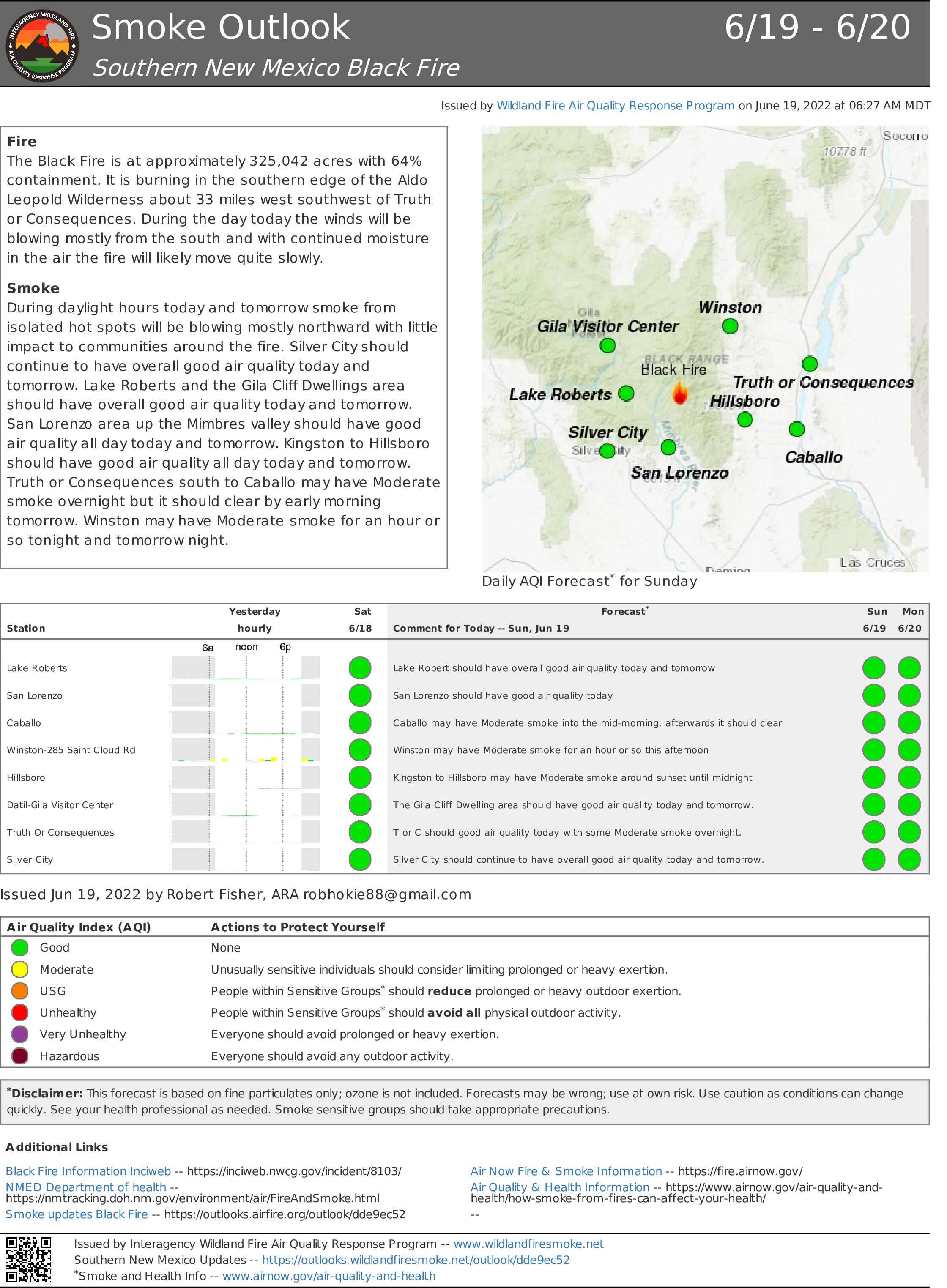
Acres: 325,042 acres
Contención: 64%
Personal total: 1,203
Causa: orígen human, a ser determinada
Fecha de inicio: Viernes 13 de mayo de 2022
Location: 31 millas al noroeste de Truth or Consequences, NM
Combustibles: Coníferas mixtas y hierba alta
Puntos importantes: el trabajo que se ha hecho para extinguir el incendio junto con las condiciones climáticas favorables han resultado en que el incendio Black esté mejor controlado. A medida que disminuye el fuego, los bomberos están comenzando a reparar las líneas de mano y de topadoras alrededor del perímetro.
La carretera New Mexico 152 ya está abierta desde el marcador de millas 40 (Kingston) hasta el marcador de millas 15 (San Lorenzo). Por favor, siga practicando precaución en el área y tenga en cuenta el aumento del tráfico de bomberos.
Para saber más sobre elestado actual deevacuación del incendio Black, vea al mapa de evacuación interactivo en tiempo real o comuníquese con su oficina local de gestión de emergencias del Condado Sierra, del Condado Catron y del Condado Grant.
Operaciones: aparte de apagar el incendio, las cuadrillas están reparando áreas donde los cortafuego creados al principio del incidente ya no son necesarias. Las tormentas de lluvia en toda el área han ayudado a disminuir los incendios y prevenir cualquier movimiento grande hacia el sur. Algo de calor permanece en el área de Hillsboro Lookout y por arriba de Upper Well Cabin a lo largo de Forest Road 4080. Los bomberos continúan con el trabajo de eliminar vegetación y el trabajo de astillado en Kingston y el área de North Percha. Los equipos de noche eliminaron exceso de vegetación en el cementerio de Kingston para que tenga mejor protección. En Hillsboro, los bomberos han evaluado lo defensible que son las estructuras en caso de que el incendio Black, o cualquier incendio futuro, se desplace hacia esta comunidad. Los bomberos trabajan en las líneas de contención para rehabilitar y ayudar a restaurar la tierra a su estado natural. A medida que las tormentas eléctricas traen más rayos al área, los bomberos responderán a cualquier nuevo incendio que empiece en el área de Restricción Temporal de Vuelo. Las aeronaves están volando sobre el fuego, a medida que las condiciones lo permiten, para evaluar el fuego y recopilar información que ayuda con los planes de extinción terrestre. Debido a que el incendio disminuye y aumentan las tormentas de noche, los bomberos estarán transicionando a turnos de dia de aquí en adelante. Algunos recursos que ya no se ocupan durante las horas nocturnas serán reasignados a otros incendios forestales en todo el suroeste.
Clima: la abundante humedad provocará lluvias y tormentas eléctricas hasta mediados de la próxima semana. Las fuertes lluvias de estas tormentas eléctricas pudieran causar inundaciones repentinas dentro y afuera del rastro de la quemadura. De lo contrario, se esperan cielos mayormente nublados, temperaturas de día más frescas y altos niveles de humedad hasta al menos principios de la próxima semana.
Cierres: una parte del Bosque Nacional de Gila afectada por el incendio Black se ha cerrado temporalmente.
Restricciones:¡Infórmese antes de salir! El público puede obtener información estatal y federal actualizada sobre las restricciones de incendios en Nuevo México en Información sobre incendios en NM| Restricciones de incendios o en la división forestal de NM Restricciones de incendios en todo el estado.
Seguridad: la prioridad más alta siempre es la salud y la seguridad de los bomberos y el público. El público debe mantenerse alejado de las operaciones del incendio Black. Una restricción temporaral de vuelo esta vigente sobre el área del incendio Black, que incluye aviones no tripulados o drones. Puede encontrar más información sobre los peligros que los drones representan para las aeronaves de extinción de incendios forestales y el personal terrestre en: https://www.nifc.gov/.
Humo: el humo del incendio Black pudiera verse en las áreas alrededor de Mimbres, Kingston, Hillsboro y San Lorenzo, NM. Se recomienda a las personas que son sensibles al humo y a las personas con problemas respiratorios o enfermedades cardíacas que tomen medidas de precaución. Puede encontrar información sobre la calidad del aire y cómo proteger la salud en el sitio web de rastreo de salud pública ambiental del Departamento de Salud de Nuevo México: nmtracking.org. Mediante un mapa interactivo de humo en https://fire.airnow.gov/ puede hacer zoom en su área para ver las últimas condiciones de humo. Para obtener información adicional, consulte el Informe de humo del incendio Black.
Se publican las actualizaciones de incendios en InciWeb, las páginas de Facebook y Twitter del Bosque Nacional Gila, e Información sobre los incendios en NM.
Correo electrónico: 2022.black@firenet.gov • Teléfono: (575)-249-1264 • Horario de oficina: 8:00 AM – 8:00 PM
Black Fire Update Sunday June 19
Related Incident:
Publication Type: News
SOUTHWESTAREA
INCIDENTMANAGEMENTTEAM
TEAM4– AARONHULBURD–INCIDENTCOMMANDER
Containment climbs on the Black Fire
June 19, 2022 Daily Update
Acres: 325,042 acres
Containment: 64%
Total Personnel: 1,203
Cause: Human-caused, under investigation
Start Date: Friday, May 13, 2022
Location: 31 miles NW of Truth or Consequences, NM
Fuels: Timber and tall grass
Cause: Human-caused, under investigation
Highlights: Successful suppression efforts and favorable weather conditions have resulted in increased containment on the Black Fire. As fire activity decreases, firefighters are beginning to repair hand lines and dozer lines around the perimeter.
New Mexico Highway 152 is now open from milepost 40 (Kingston) to milepost 15 (San Lorenzo). Please continue to use caution in the area and be mindful of firefighters working in the area and increased fire traffic.
To learn about the current evacuation status for the Black Fire, please access the real-time, interactive evacuation map or contact your local emergency management office for Sierra County, Catron County, and Grant County.
Operations: In addition to suppressing the fire, crews are working to repair areas where fire lines created early in the incident are no longer needed. Rainstorms throughout the area have helped to diminish fire activity and prevent any significant movement to the south. Some heat remains in the Hillsboro Lookout area and above Upper Well Cabin along Forest Road 4080. Firefighters continue with vegetation removal and chipping operations in Kingston and the North Percha area. Nightshift crews successfully cleared excess vegetation in the Kingston Cemetery for added protection. In Hillsboro, firefighters have assessed the defensibility of structures in the event that the Black Fire, or any future fires, move toward this community. Firefighters are working along containment lines to perform rehabilitation work to help restore the land back to its natural state. As thunderstorms bring more lightning into the area, fire crews will respond to any new fire starts located in the Temporary Flight Restriction area. As conditions allow, firefighters are flying over the fire to assess fire activity and gather information to inform the suppression plans on the ground. With reduced fire activity and increasing evening storms, firefighters are transitioning to daytime shifts only moving forward. Some fire resources that are no longer needed during the nighttime hours will be reassigned to other wildfires across the Southwest.
Weather: Plentiful moisture will lead to showers and thunderstorms into the middle of next week. Heavy rainfall from these thunderstorms may result in flash flooding in and around the burn scar. Otherwise, mostly cloudy skies, cooler daytime temperatures, and high humidity levels are expected through at least early next week.
Closures: A portion of the Gila National Forest affected by the Black Fire has been temporarily closed.
Restrictions: Know Before You Go! The public can obtain current state and federal fire restriction information across New Mexico at NM Fire Info | Fire Restrictions or NM Forestry Division state-wide fire restrictions.
Safety: The health and safety of firefighters and the public is always the top priority. Members of the public should stay away from Black Fire operations. A Temporary Flight Restriction is in place over the Black Fire area, which includes unmanned aircraft, or drones. More information on the dangers drones pose to wildland firefighting aircraft and personnel on the ground can be found at: https://uas.nifc.gov/.
Smoke: Smoke from the Black Fire may be visible in the surrounding areas of Mimbres, Kingston, Hillsboro, and San Lorenzo, NM. Smoke-sensitive individuals and people with respiratory problems or heart disease are encouraged to take precautionary measures. Information on air quality and protecting your health can be found at the New Mexico Department of Health Environmental Public Health Tracking website: nmtracking.org. An interactive smoke map at https://fire.airnow.gov/ allows you to zoom into your area to see the latest smoke conditions. For additional information, please view the Black Fire Smoke Report.
Fire updates are posted on InciWeb, the Gila National Forest Facebook and Twitter pages, and NM Fire Information.
Email: 2022.black@firenet.gov
Phone: (575)-249-1264
Office Hours: 8:00 AM – 8:00 PM
Actualizacin diaria del 18 de junio de 2022
Related Incident:
Publication Type: News
Lluvia cae sobre el incendio Black y se abre de nuevo la carretera New Mexico 152
Actualización diaria del 18 de junio de 2022
Acres: 324,909 acres
Contención: 58%
Personal total: 1,300
Causa: de orígen humano, a ser determinada
Fecha de inicio: Viernes 13 de mayo de 2022
Ubicación: 31 millas al noroesteTruth or Consequences, NM
Combustibles: Coníferas mixtas y hierba alta
Puntos importantes: varía la cantidad de lluvia a lo largo del incendio. En partes donde el suelo está seco, la humedad se evapora rápidamente. En otras áreas, las lluvias más intensas pueden causar erosión, inundaciones repentinas y flujos de escombros por las laderas que se derrama sobre las carreteras.
La carretera New Mexico 152 ya está abierta desde el marcador de millas 40 (Kingston) hasta el marcador de millas 15 (San Lorenzo). Por favor, siga practicando precaución en el área y tenga en cuenta el aumento del tráfico de bomberos.
Para saber más sobre el estado actual de evacuación del incendio Black, vea al mapa de evacuación interactivo en tiempo real o comuníquese con su oficina local de gestión de emergencias del Condado Sierra, del Condado Catron y del Condado Grant.
Operaciones: ya hay más contención del incendio cerca de Round Mountain y Las Animas Creek. Los bomberos continúan monitoreando el derrame cerca de Bloodgood Place, aunque esta parte del fuego no ha avanzado en varios días. El fuego desplazándose lentamente hacia el sur por el área de Aldo Leopold Wilderness y la que quemó el incendio Silver en 2013. En la esquina noroeste del incendio, los bomberos localizaron y extinguieron dos pequeños focos de calor que detectaron usando imágenes infrarrojas de un sistema de aeronave no tripulado. En el área de Kingston y North Percha Creek, están eliminando la vegetación, astillando matorrales y ramas de árboles, y probando sistemas de rociadores. En general, los mayores niveles de humedad están ayudando a frenar la actividad de los incendios en el sur. Debido a la mayor humedad, las condiciones han sido favorables para que las cuadrillas quemen secciones lentamente en la esquina suroeste. Al encender fuego de baja intensidad en el lado este de Forest Road 4080, están eliminando la vegetación antes de que el fuego principal avance al oeste hacia esta carretera. Al eliminar esta vegetación se evita que el fuego principal gane suficiente intensidad como para cruzar posiblemente esta carretera.
Clima: la humedad abundante provocará lluvias y tormentas eléctricas hasta principios de la próxima semana. Las fuertes lluvias pueden causar inundaciones repentinas dentro y alrededor del rastro de la quemadura. Se espera un aumento en la nubosidad, temperaturas de día más frías y niveles de humedad mayores hasta principios de la próxima semana.
Cierres: una parte del Bosque Nacional de Gila afectada por el incendio Black se ha cerrado temporalmente.
Restricciones: ¡Infórmese antes de salir! El público puede obtener información estatal y federal actualizada sobre las restricciones de incendios en Nuevo México en Información sobre incendios en NM| Restricciones de incendios o en la división forestal de NM Restricciones de incendios en todo el estado.
Seguridad: la prioridad más alta siempre es la salud y la seguridad de los bomberos y el público. El público debe mantenerse alejado de las operaciones del incendio Black. Una restricción temporaral de vuelo esta vigente sobre el área del incendio Black, que incluye aviones no tripulados o drones. Puede encontrar más información sobre los peligros que los drones representan para las aeronaves de extinción de incendios forestales y el personal terrestre en: https://www.nifc.gov/drones/.
Se publican las actualizaciones de incendios en InciWeb, las páginas de Facebook y Twitter del Bosque Nacional Gila, e Información sobre los incendios en NM.
Correo electrónico: 2022.black@firenet.gov • Teléfono: (575)-249-1264 • Horario de oficina: 8:00 AM – 8:00 PM