
incendio Black Actualizacin diaria del 14 de junio de 2022
Related Incident:
Publication Type: News
EQUIPO DE GESTIÓN DE
INCIDENTES DEL ÁREA DEL SUROESTE
EQUÍPO 4 – AARON HULBUR – COMANDANTE DEL INCIDENTE
El Equipo 4 de gestión de incidentes tipo 2 del área del suroeste asume el mando del
incendio Black
Actualización diaria del 14 de junio de 2022
Acres: 312,519 acres
Fecha de inicio: 13 de mayo de 2022
Causa: De origen humano, a ser determinada
Contención: 47%
Personal total: 1,019
Ubicación: 31 millas al noroeste de Truth or
Consequences
Combustibles: Coníferas mixtas y hierba alta
Puntos importantes: esta mañana del martes 14 de mayo de 2022 a las 6:00 AM, el Equipo 4 de gestión de incidentes tipo 2 del área del suroeste, dirigido por el Comandante de Incidentes Aaron Hulburd, asumió el mando del incendio Black. Este equipo continuará con la estrategia de extinción completa que implementó el equipo 3 del área del suroeste durante las últimas semanas.
Para saber más sobre el estado actual de evacuación del incendio Black, vaya al mapa de evacuación interactivo en tiempo real o comuníquese con su oficina local de gestión de emergencias del Condado Sierra, el Condado Catron y el Condado Grant.
Operaciones: A medida que el Equipo 4 asume el mando, los bomberos desarrollarán estrategias adicionales para frenar el fuego por completo mientras que al mismo tiempo se protegen los recursos valiosos en el área. Las cuadrillas están trabajando a lo largo del borde del incendio cerca de Seco Creek, Round Mountain y Animas Creek para extinguir el incendio directamente. Según lo que vieron los bomberos, tal vez enciendan estratégicamente la vegetación interior para iniciar un fuego de baja intensidad que se desplaze más lentamente hacia las líneas de control. Una estrategia como esta ayuda a eliminar combustible del fuego principal, y así es menos probable que se ponga más fuerte y llegue a extenderse más allá de las líneas de control establecidas. Los bomberos continúan vigilando focos de calor en Animas Creek debido a los combustibles pesados en esta área. Las cuadrillas han completado actividades de preparación para eliminar la vegetación a lo largo de North Percha Road junto con proteger las estructuras en Kingston. Los equipos de bomberos siguen con el trabajo de astillado a lo largo de la carretera 152 en caso de que el incendio llegue a avanzar hacia esta carretera. Están trabajando en las áreas de Rocky Canyon, Bloodgood Place y Forest Service Roads 151 y 152 para localizar y extinguir cualquier calor cerca del borde del incendio. No se han detectado nuevos incendios dentro de la restricción temporal de vuelo sobre el área del incendio Black.
Clima: por la tarde, especialmente el día de hoy, se esperan condiciones secas y ventosas que durarán hasta el miércoles. También habrá temperaturas cálidas y baja humedad hasta el miércoles. La humedad regresará al área el jueves y durará hasta el próximo fin de semana a medida que aumentan las posibilidades de tormentas eléctricas. Al principio las tormentas eléctricas empezarán secas, pero se volverán más húmedas a medida que trabajamos hacia el fin de semana.
Cierres: la carretera 152 está actualmente cerrada desde el marcador de millas 40 (Kingston) hasta el marcador de millas 15 (San Lorenzo). No se permite la entrada pública . Una parte del Bosque Nacional de Gila afectada por el incendio ha sido cerrada.
Restricciones: ¡Infórmese antes de salir! El público puede obtener información estatal y federal actualizada sobre las restricciones de incendios en Nuevo México en Información de incendios | Restricciones de incendios de NM o en restricciones estatales de incendios de la División forestal de NM: https://www.emnrd.nm.gov/sfd/find-current-fire-restrictions/
Seguridad: La prioridad más alta siempre es la salud y la seguridad de los bomberos y el público. El público debe mantenerse alejado de las operaciones del incendio Black. Una restricción temporaral de vuelo esta vigente sobre el área del incendio Black, que incluye aviones no tripulados o drones. Puede encontrar más información sobre los peligros que los drones representan para las aeronaves de extinción de incendios forestales y el personal terrestre en: https://www.nifc.gov/drones/.
Humo: El humo del incendio Black se puede ver en las áreas alrededor de Mimbres, Kingston, Hillsboro y San Lorenzo, NM. Se recomienda a las personas que son sensibles al humo y a las personas con problemas respiratorios o enfermedades cardíacas que tomen medidas de precaución. Puede encontrar información sobre la calidad del aire y cómo proteger la salud en el sitio web de rastreo de salud pública ambiental del Departamento de Salud de Nuevo México: nmtracking.org. Mediante un mapa interactivo de humo en https://fire.airnow.gov/ puede hacer zoom en su área para ver las últimas condiciones de humo. Para obtener información adicional, consulte el Informe de humo de fuego negro.
Se publican las actualizaciones de incendios en InciWeb, las páginas de Facebook y Twitter del Bosque Nacional Gila, e Información sobre los incendios en NM.
Correo electrónico: 2022.black@firenet.gov • Teléfono: (575)-249-1264 • Horario de oficina: 8:00 AM – 8:00 PM
Black Fire Daily Update Tuesday June 14 2022
Related Incident:
Publication Type: News
SOUTHWEST AREA
INCIDENT MANAGEMENT TEAM
TEAM 4 – AARON HULBURD – INCIDENT COMMANDER
Southwest Area Type 2 Incident Management Team 4 Assumes Command of Black Fire
June 14, 2022 Daily Update
Acres: 312,519 acres
Start Date: Friday, May 13, 2022
Cause: Human-caused, under investigation
Containment: 47%
Total personnel: 1,019
Location: 31 miles NW of Truth or Consequences
Fuels: Timber and tall grass
Highlights: The Southwest Area Type 2 Incident Management Team 4, led by Incident Commander Aaron Hulburd, assumed command of the Black Fire at 6:00 AM this morning, Tuesday, May 14, 2022. Southwest Team 4 will continue the full suppression strategy implemented by Southwest Team 3 over the previous weeks.
To learn about the current evacuation status for the Black Fire, please access the real-time, interactive evacuation map or contact your local emergency management office for Sierra County, Catron County, and Grant County.
Operations: As Team 4 assumes command, firefighters will develop additional strategies to fully contain the fire while protecting valuable resources in the area. Crews are working along the fire’s edge near Seco Creek, Round Mountain, and Animas Creek to directly suppress the fire. Based on observed fire behavior, firefighters may strategically ignite interior vegetation to produce a low intensity fire that moves more slowly toward control lines. This strategy helps to rob the main fire of fuel, so it is less likely to gain intensity and spread beyond the established control lines. Firefighters continue to observe hot spots in Animas Creek due to heavy fuels in this area. Crews have completed preparation activities to remove vegetation along the North Percha Road along with structure protection efforts in Kingston. Fire crews continue chipping operations along Highway 152 in the event the fire advances towards this road. Firefighters are working in the areas of Rocky Canyon, Bloodgood Place, and Forest Service Roads 151 and 152 to locate and extinguish any heat near the edge of the fire. No new fire starts have been detected within the Temporary Flight Restriction over the Black Fire area.
Weather: Dry and breezy afternoon conditions are expected through Wednesday, especially today. Hot temperatures and low humidity will also occur through Wednesday. Moisture moves back into the area Thursday into the upcoming weekend as chances for thunderstorms increase. Thunderstorms will initially start off dry but should become more wet as we work into the weekend.
Closures: Highway 152 is currently closed from milepost 40 (Kingston) to milepost 15 (San Lorenzo). No public entry is allowed. A portion of the Gila National Forest affected by the fire has been closed.
Restrictions: Know Before You Go! The public can obtain current state and federal fire restriction information across New Mexico at NM Fire Info | Fire Restrictions or NM Forestry Division state-wide fire restrictions.
Safety: The health and safety of firefighters and the public is always the top priority. Members of the public should stay away from Black Fire operations. A Temporary Flight Restriction is in place over the Black Fire area, which includes unmanned aircraft, or drones. More information on the dangers drones pose to wildland firefighting aircraft and personnel on the ground can be found at: https://www.nifc.gov/drones/.
Smoke: Smoke from the Black Fire may be visible in the surrounding areas of Mimbres, Kingston, Hillsboro, and San Lorenzo, NM. Smoke-sensitive individuals and people with respiratory problems or heart disease are encouraged to take precautionary measures. Information on air quality and protecting your health can be found at the New Mexico Department of Health Environmental Public Health Tracking website: nmtracking.org. An interactive smoke map at https://fire.airnow.gov/ allows you to zoom into your area to see the latest smoke conditions. For additional information, please view the Black Fire Smoke Report.
Fire updates are posted on InciWeb, the Gila National Forest Facebook and Twitter pages, and NM Fire Information.
Email: 2022.black@firenet.gov •Phone: (575)-249-1264 •Office Hours: 8:00 AM – 8:00 PM
Black Fire Daily Update June 13 2022
Related Incident:
Publication Type: News
Red Flag Winds / Transfer of Command
Acres: 311,692 acres
Location: 31 miles NW of Truth or Consequences
Containment: 47%
Personnel: 1019
Start Date: Friday, May 13, 2022
Cause: Human-caused, under investigation
Fuels: Timber and tall grass
Structures Lost: 5
Road Closure: NM 152 is currently closed, from mileposts 40 (Kingston) to milepost 15 (San Lorenzo). No entry will be allowed. A portion of the Gila National Forest affected by the fire has been closed.
To learn about the current evacuation status for the Black Fire, please access the real-time, interactive evacuation map or contact your local jurisdiction’s emergency management agencies.
On Tuesday, June 14 at 6:00 a.m., Transfer of Command will occur from Southwest Area Incident Management Team 3, Incident Commander Lance Elmore to Southwest Area Incident Management Team 4, Incident Commander Aaron Hulburd.
Today, red flag winds are expected while hot and dry conditions persist with single digit humidity levels.
Firefighters are using direct (creating hand line against the fire’s edge) and indirect (building fire line using bulldozers and existing roads out ahead of the fire) tactics to fully suppress the fire. No fire growth has been reported in the Hermosa, Seco Creek, and Round Mountain areas for the past few days and these areas will be monitored and patrolled. Firefighters are working along the edge of the fire to create a containment line within Mineral Creek to Frank’s Mountain and Apache Creek. Firefighters are also creating hand and dozer line near Iron Road. Steady growth is expected on the south side of the fire in East Canyon, crest of the Black Range northwest of Hillsboro Mountain and Granite Mountain. The majority of any visible smoke is from fuels burning in the interior parts of the fire. Aerial resources will be used to assist firefighters on the ground as the weather conditions allow. Unmanned Aerial Systems are being used at night to patrol the fire to locate hot spots.
Weather: Red Flag Warning 12:00 p.m. through 8:00 p.m. Strong winds are expected today and breezy conditions Tuesday afternoon. There will be a slight chance of dry thunderstorms today, with dry conditions Tuesday and Wednesday. Warm to hot temperatures, low day time relative humidities and lowering night-time RH recoveries will occur through Wednesday. Moisture moves back into the area Thursday into the upcoming weekend, for an increased chance of thunderstorms
Aviation Restrictions: A Temporary Flight Restriction (TFR) over the Black Fire restricts non-fire aircraft. This includes civilian drones. Unauthorized aircraft in the area can ground firefighting aircraft, hinder firefighting efforts, and can also result in criminal charges for the offender.
Fire Restrictions: Know Before You Go! The public can obtain current state and federal fire restriction information across New Mexico at NM Fire Info | Fire Restrictions or at NM Forestry Division state-wide fire restrictions
More Information:
Black Fire Daily Update June 12 2022
Related Incident:
Publication Type: News
Firefighters Continue to Work in Hot, Dry, and Windy Conditions
Acres: 305,204 acres
Location: 31 miles NW of Truth or Consequences
Containment: 42%
Personnel: 1005
Start Date: Friday, May 13, 2022
Cause: Human-caused, under investigation
Fuels: Timber and tall grass
Structures Lost: 5
Road Closure: NM 152 is currently closed, from mileposts 40 (Kingston) to milepost 15 (San Lorenzo). No entry will be allowed. A portion of the Gila National Forest affected by the fire has been closed.
To learn about the current evacuation status for the Black Fire, please access the real-time, interactive evacuation map or contact your local jurisdiction’s emergency management agencies.
Firefighters are working in hot, dry, and windy conditions to fully suppress the Black Fire. Humidity levels have increased for a short period of time within a small part of the fire because of the storms passing, but very little rain has fallen over the fire. Aggressive fire behavior is occurring due to weather conditions and topography.
Firefighters are working day and night shifts around the entire fire area. Firefighters have been scouting for natural features on the landscape within the southern fire perimeter that can be used as holding features to stop the fire. There was little fire growth in the Granite Peak area. Firefighters are chipping vegetation along the Continental Divide Trail, and they have completed structure protection in Thunderbird Campground. Firefighters are improving existing containment lines and patrolling around the fire. There were no new fire starts within the Black Fire Temporary Flight Restriction (TFR) area.
Please be cautious if driving in the areas where firefighters are working and be aware of increased fire traffic.
Weather: Isolated afternoon and evening dry thunderstorms are expected today, with a slight chance of thunderstorms on Monday. Dry conditions return Tuesday and Wednesday. Warm to hot temperatures, low daytime relative humidity and lowering night-time RH recoveries will occur through Wednesday. Stronger winds are expected through Tuesday, especially Monday when critical fire weather conditions may occur.
Aviation Restrictions: A Temporary Flight Restriction (TFR) over the Black Fire restricts non-fire aircraft. This includes civilian drones. Unauthorized aircraft in the area can ground firefighting aircraft, hinder firefighting efforts, and can also result in criminal charges for the offender.
Fire Restrictions: Know Before You Go! The public can obtain current state and federal fire restriction information across New Mexico at NM Fire Info | Fire Restrictions or at NM Forestry Division state-wide fire restrictions
More Information:
Black Fire Daily Update June 11 2022
Related Incident:
Publication Type: News
Black Fire Receives Minimal Rain
Acres: 304,550 acres
Location: 31 miles NW of Truth or Consequences
Containment: 42%
Personnel: 1009
Start Date: Friday, May 13, 2022
Cause: Human-caused, under investigation
Fuels: Timber and tall grass
Structures Lost: 5
Road Closure: NM 152 is currently closed, from mileposts 40 (Kingston) to milepost 15 (San Lorenzo). No entry will be allowed. A portion of the Gila National Forest affected by the fire has been closed.
To learn about the current evacuation status for the Black Fire, please access the real-time, interactive evacuation map or contact your local jurisdiction’s emergency management agencies.
The Black Fire has not received much rain from the passing storms, but it did increase relative humidity levels for a short time. Containment line was added in the Hermosa area and there was fire growth in the Granite Peak area. Firefighters rappelled by helicopter into the Mineral Creek and Lookout Mountain area to assess the isolated heat and implemented direct suppression tactics. Along Highway 152, firefighters are removing and chipping brush to prepare this road as a holding line in case fire moves towards Emory Pass. In Kingston, firefighters are setting up sprinkler systems and removing fuels for protection purposes. Unmanned Aerial System (UAS) or drone like device is being used by firefighters to monitor the fire line in the McKnight area and patrol for any new fire starts due to lightning. Minimum Impact Suppression Tactics are being used in the Gila Wilderness, which means fire lines created are smaller than normal and less vegetation is removed. Thunderstorms are forecast again for tomorrow. Otherwise conditions of hot temperatures, dry fuels and winds remain in place.
There is a lot of fire traffic and firefighters working along the fire area, please be cautious if driving in these areas.
Weather: Limited moisture will result in isolated mainly afternoon and evening dry thunderstorms through Sunday. Expect warm to hot temperatures, low daytime relative humidity and lowering night-time RH recoveries into the middle of next week. Stronger winds are expected through Tuesday, especially Monday with near critical conditions.
Aviation Restrictions: A Temporary Flight Restriction (TFR) over the Black Fire restricts non-fire aircraft. This includes civilian drones. Unauthorized aircraft in the area can ground firefighting aircraft, hinder firefighting efforts, and can also result in criminal charges for the offender.
Fire Restrictions: Know Before You Go! The public can obtain current state and federal fire restriction information across New Mexico at NM Fire Info | Fire Restrictions or at NM Forestry Division state-wide fire restrictions
More Information:
Black Fire Daily Update June 10 2022
Related Incident:
Publication Type: News
Black Fire is Officially the Second Largest Wildfire in New Mexico History
Acres: 300,336 acres
Location: 31 miles NW of Truth or Consequences
Containment: 42%
Personnel: 947
Start Date: Friday, May 13, 2022
Cause: Human-caused, under investigation
Fuels: Timber and tall grass
Structures Lost: 2
New Road Closure: NM 152 is currently closed, from mileposts 40 (Kingston) to milepost 15 (San Lorenzo). No entry will be allowed. A portion of the Gila National Forest affected by the fire has been closed.
To learn about the current evacuation status for the Black Fire, please access the real-time, interactive evacuation map or contact your local jurisdiction’s emergency management agencies.
The Black Fire is officially the second largest wildfire in New Mexico. Firefighters are conducting multiple tactics which include: chipping for suppression repair; scouting areas to build hand and bulldozer fire line; structure assessment and protection; burnout operations to remove fuels between the constructed fire lines and the main fire; and using aircraft for fire suppression efforts, aerial ignition, recon and monitoring as weather conditions allow. Thunderstorms are forecast again for tomorrow and then hot and dry weather conditions will return.
Firefighters responded to three lightning ignitions located south of Highway 152, one near Sawyer Peak the other two just south of Emory pass. The area designated withing the temporary flight restriction will continue to be monitored for any new fire starts near the Black Fire.
There is a lot of fire traffic and firefighters working along the fire area, please be cautious if driving in these areas.
Weather: Scattered thunderstorms will form once again over the fire by the late morning and will continue into the evening. This is followed by another night of mostly terrain driven winds and decent relative humidity recoveries. Thunderstorm chances will continue into the weekend.
Aviation Restrictions: A Temporary Flight Restriction (TFR) over the Black Fire restricts non-fire aircraft. This includes civilian drones. Unauthorized aircraft in the area can ground firefighting aircraft, hinder firefighting efforts, and can also result in criminal charges for the offender.
Fire Restrictions: Know Before You Go! The public can obtain current state and federal fire restriction information across New Mexico at NM Fire Info | Fire Restrictions or at NM Forestry Division state-wide fire restrictions
More Information:
Road Closure Change NM 59 Beaverhead Rd is now open
Related Incident:
Publication Type: Announcement
WINSTON –Due to the continuation of the Black wildfire in the Gila National Forest. The New Mexico Department of Transportation is assisting with the below roadway closures for the safety of the traveling public and fire fighters in the area.
NM 59 “Beaverhead Rd.” is now open. Proceed with caution.
CONTINUED CLOSURE:
NM 152 is closed from mileposts 40 (Kingston) to milepost 15 (San Lorenzo). No entry will be allowed.
For more information on wildfires, please visit https://maps.nwcg.gov/sa/.
Black Fire Daily Update June 9 2022
Related Incident:
Publication Type: News
Another Heads-Up Day Due to Weather / Community Meeting Tonight at 6 p.m. in Kingston
Acres: 298,440 acres
Location: 31 miles NW of Truth or Consequences
Containment: 44%
Personnel: 918
Start Date: Friday, May 13, 2022
Cause: Human-caused, under investigation
Fuels: Timber and tall grass
Structures Lost: 2
Community Meeting Tonight at 6 p.m. at the Black Range Lodge in Kingston, NM.
New Road Closure: NM 152 will be closed starting at 8 a.m., from mileposts 40 (Kingston) to milepost 15 (San Lorenzo). No entry will be allowed.
NM Hwy 59 “Beaverhead Road” will remain closed to traffic from Forest Road 150 to New Mexico Highway 52 between the hours of 8:00 a.m. to 6:00 p.m. to provide safety for firefighters working along the roadway. The New Mexico Highway 59 will be open to traffic between the hours of 6:00 p.m. to 8:00 a.m. A portion of the Gila National Forest affected by the fire has been closed.
To learn about the current evacuation status for the Black Fire, please access the real-time, interactive evacuation map or contact your local jurisdiction’s emergency management agencies.
The current weather pattern is increasing humidity levels, but lightning strikes and gusty winds are a concern. Yesterday, firefighters were pulled off the fire line for a while to take shelter from the lightning. Firefighters also responded to two new fires located near Emery Pass that were started by lightning strikes.
Firefighter resources continue to arrive, including a helicopter rappelling firefighter crew who will access Mineral Creek to assess isolated heat sources and work on fire suppression. Firefighters continue to monitor and patrol the fire along the existing containment lines. Structure assessments have been completed in Ladder Ranch and chipping operations continue along Highway 152. Aluminum wrap has been placed on a communication tower near Emory Pass for protection. Aircraft will be used as weather conditions allow.
Weather: Scattered thunderstorms will form again over the fire by the later morning and will continue into the evening. This
is followed by another night of mostly terrain driven winds and decent relative humidity recoveries. Thunderstorm chances
Aviation Restrictions: A Temporary Flight Restriction (TFR) over the Black Fire restricts non-fire aircraft. This includes civilian drones. Unauthorized aircraft in the area can ground firefighting aircraft, hinder firefighting efforts, and can also result in criminal charges for the offender.
Fire Restrictions: Know Before You Go! The public can obtain current state and federal fire restriction information across New Mexico at NM Fire Info | Fire Restrictions or at NM Forestry Division state-wide fire restrictions
More Information:
Road Closure Change NM 152 To be Closed beginning June 9 2022
Related Incident:
Publication Type: Announcement
FOR IMMEDIATE RELEASE FROM THE NEW MEXICO DEPARTMENT OF TRANSPORTATION
Wildfire threat leads to an additional road closure in southwest N.M.
KINGSTON –Due to the Black wildfire, an additional road closure is in place.
NM 152 will be closed beginning June 9, 2022, at 8 a.m., from mileposts 40 (Kingston) to milepost 15 (San Lorenzo). No entry will be allowed.
CONTINUED CLOSURE:
NM 59 “Beaverhead Rd.” will remain closed to traffic from Forest Road 150 to New Mexico Highway 52 between the hours of 8:00 a.m. to 6:00 p.m. to provide safety for firefighters working along the roadway. Roadway will reopen to traffic between the hours of 6:00 p.m. to 8:00 a.m.
For more information on wildfires, please https://maps.nwcg.gov/sa/.
The New Mexico Department of Transportation is committed to the safety of the traveling public and appreciates your cooperation during this time. For the latest road information visit: The New Mexico Department of Transportation at www.nmroads.com or call 511.
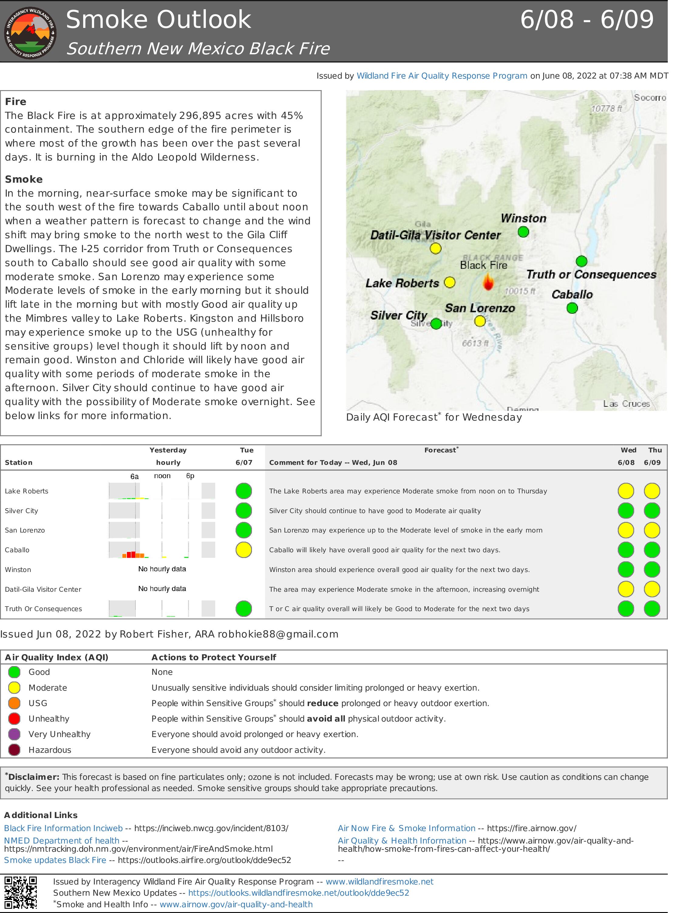
Black Fire Daily Update June 8 2022
Related Incident:
Publication Type: News
Weather Changes Expected Next Few Days / Community Meeting Thursday at 6 p.m. in Kingston
Acres: 296,895 acres
Location: 31 miles NW of Truth or Consequences
Containment: 45%
Personnel: 905
Start Date: Friday, May 13, 2022
Cause: Human-caused, under investigation
Fuels: Timber and tall grass
Structures Lost: 2
Community Meeting Thursday at 6 p.m. at the Black Range Lodge in Kingston, NM.
Road Closures: NM Highway 59 will remain closed to traffic from Forest Road 150 to New Mexico Highway 52 between the hours of 8:00 a.m. to 6:00 p.m. to provide safety for firefighters working along the roadway. The New Mexico Highway 59 will be open to traffic between the hours of 6:00 p.m. to 8:00 a.m. A portion of the Gila National Forest affected by the fire has been closed.
As the Southwestern monsoon season draws nearer, thunderstorms are forecast for the next few days. These storms will increase relative humidity levels but are also expected to bring strong, gusty wind and dry lightning.
Suppression operations on the Black Fire include activities, such as: construction of hand line and dozer line; structure protection in the Ladder Ranch and Percha Creek areas; chipping operations in Kingston; and patrolling the fire area. Aluminum wrap has been placed on the Carbonite cabin and chipping operations are complete along the existing containment lines.
A new fire camp is being established to the east of Hillsboro and the fire camps in Winston and Kingston will be closed. This allows for firefighters working in this area to have a shorter drive time, thereby providing safety for our firefighters.
Aircraft are supporting a unique mission to transport Gila trout from Diamond creek to relocate outside of the fire area.
Weather: The winds will become more terrain driven as high pressure moves into the region. There is a chance of thunderstorms over the fire in the afternoon, followed by higher maximum relative humidity. Thunderstorms will continue into the weekend.
Aviation Restrictions: A Temporary Flight Restriction (TFR) over the Black Fire restricts non-fire aircraft. This includes civilian drones. Unauthorized aircraft in the area can ground firefighting aircraft, hinder firefighting efforts, and can also result in criminal charges for the offender.
Fire Restrictions: Know Before You Go! The public can obtain current state and federal fire restriction information across New Mexico at NM Fire Info | Fire Restrictions or at NM Forestry Division state-wide fire restrictions
More Information: