
Black Fire Update 5302022
Related Incident:
Publication Type: News
Containment Increases on the Black Fire Despite Windy Conditions
Daily Update 5/30/2022
Acres: 241,403 acres
Location: 31 miles NW of Truth or Consequences
Containment: 26%
Personnel: 756
Start Date: Friday, May 13, 2022
Cause: Human-caused, under investigation
Fuels: Timber and tall grass
Structures Lost: 2
Overview: A real-time, interactive evacuation map is now available. The map provides current information on evacuation status for the Black Fire. For individual inquiries, please contact your local jurisdiction’s emergency management agencies. This will be the last day for Southwest Area Incident Management Team 5. Southwest Area Incident Management Team 3 will take over command of the Black Fire at 6 am, Tuesday morning. Thank you for your hospitality and support during our time in your communities.
Fire Update: Containment increased on the Black Fire to 26% despite windy conditions yesterday.
North: On the northwest side of the fire, firing operations continue as crews extend established containment lines from Forest Road 150 east. Crews patrol and secure the area by extinguishing and removing burning material near control lines, felling trees where needed, and trenching logs to prevent rolling after the fire.
South: The Black Fire is burning in the Silver Fire scar towards McKnight Mountain and Lake Mountain, fueled by thick grasses from last year’s heavy monsoons and dead trees that remain from the Silver Fire burn scar. Air tankers and helicopters are being used along the southwest corner of the fire perimeter so that firefighters can complete fireline. Crews are scouting areas to build firelines ahead of the fire as it progresses south.
East: The fire reached Franks Mountain and remains active in the Mineral Creek area. Crews are protecting private inholdings ahead of the fire and are prepared to conduct firing operations should they be needed. There has been minimal heat observed along the fire perimeter in the Daugherty area over the past few days. Today, firefighters will continue to monitor and secure the area where hand ignition operations were conducted near Hermosa. Crews are prepping the N. Seco Road southeast of the fire. Fire is expected to spread in the Palomas Creek drainage.
West: Containment lines are holding. Crews will patrol, secure, and monitor the area focusing on the area along Road 150 also known as North Star Mesa Rd. between Meown and Brannon Trail.
Weather: Red flag warning in effect today. High temperatures, gusty winds, and low humidity add to active fire behavior. Temperatures: 80-83 degrees. Winds: Gusts up to 40mph from the southwest. Relative Humidity: 7-11%.
Evacuation Update: Please reference the Ready, Set, Go evacuation map, or view the interactive map.
GO –
Area 1: From Burnt Cabin west along the south side of NM Highway 59 to the junction with Forest Road 150, then south along the east side of Forest Road 150 back to where it connects to Area 2.
Area 2: All of area 2. (View map)
Area 3: The northernmost one-mile-wide piece. This includes the Murden property.
Area 4: Areas in Sierra County, from the Continental Divide Scenic Trail to just east of the Gila National Forest
Boundary, including Hermosa and Mud Spring Mountain.
Area 5: Areas in Grant County, including the Forest Road 150 corridor 1.5 miles south of Tom Moore Trailhead.
Area 6: East of Forest Road 150 to the Continental Divide Scenic Trail.
Area 7: East of Forest Road 150 to the Continental Divide Scenic Trail.
Area 8: The area east of Forest Road 150 to the Gila National Forest boundary, including the Continental
Divide Scenic Trail, Victorio Park Mountain, Flagpole Mountain, and Pack Trail.
Area 11: South of Area 8, east of Forest Road 150. This includes Cooney, McKnight Cabin, The Continental Divide Scenic Trail, and Kelly Mesa.
SET –
Area 1: Parts of Catron and Sierra Counties, including Beaverhead and Poverty Creek.
Area 3: Areas in Sierra County, including Winston and Chloride.
Area 6: The area west of Forest Road 150 in Grant County.
Area 7: The area west of Forest Road 150, including the Rocky Canyon Campground.
Area 8: The area west of Forest Road 150, beginning at the south end of Area 7, then approximately four miles south, and approximately 9-10 miles west.
Area 9: From the north edge of Area 1, north along the Forest Boundary four miles, east approximately 24 miles, then south back to the Area 1 set northern edge.
Area 11: The area south of Area 8 on the west side of Forest Road 150. This includes V Cross Ranch, Lake Roberts, and Sapillo Campground.
Area 12: The area south of Area 11. East of Forest Road 150 and east of State Highway 35 and Forest Road 150, approximately 4 miles wide, including private property on the east side of Highway 35 and Forest Road 150.
READY –
Area 10: From the northern edge of Area 9, north three miles, then east approximately 24 miles, then south three miles to the edge of Area 9.
These evacuations are issued by the sheriffs of Grant, Catron, and Sierra counties. Learn about the Ready, Set, Go evacuation program: https://www.emnrd.nm.gov/sfd/fire-prevention-programs/ready-set-go-new-mexico/
Closures: Highway 59 is closed from Mud Hole to the 59/150 intersection. Forest Road 150 is also closed at the North Star Helispot. I-25 and other state highways remain open. A portion of the Gila National Forest affected by the fire has been closed.
Smoke Info:
Socorro will see periods of moderate to USG (unhealthy for sensitive groups).
Winston and Chloride will start the day with moderate air quality switching to USG (unhealthy for sensitive groups) air quality as winds pick up again today.
Mimbres, Hanover, and San Lorenzo along the Mimbres River drainage will see good air quality as winds push smoke to the east.
Truth or Consequences will have moderate air quality with possible periods of USG. Blowing dust and debris will also reduce air quality and visibility today.
Aviation Restrictions: A Temporary Flight Restriction (TFR) over the Black Fire restricts non-fire aircraft. This includes civilian drones. Unauthorized aircraft in the area can ground firefighting aircraft and hinder firefighting efforts, and it can also result in criminal charges for the offender.
Fire Restrictions:
The Gila National Forest in Stage 2 Fire Restrictions: https://www.fs.usda.gov/alerts/gila/alerts-notices/?aid=73002
NM Forestry Division state-wide fire restrictions: https://www.emnrd.nm.gov/sfd/find-current-fire-restrictions/
More Information:
Inciweb: https://inciweb.nwcg.gov/incident/8103/
New Mexico Fire information: https://nmfireinfo.com/
Facebook: https://www.facebook.com/GilaNForest
Twitter: https://twitter.com/gilanforest
Smoke Info: https://outlooks.airfire.org/outlook/dde9ec52
NM Road Information: www.nmroads.com/
Area Closure:
Black Fire Daily Update 5292022
Related Incident:
Publication Type: News
Red flag conditions continue
New interactive evacuation map available
Daily Update 5/29/2022
Acres: 228,311 acres
Location: 31 miles NW of Truth or Consequences
Containment: 19%
Personnel: 756
Start Date: Friday, May 13, 2022
Cause: Human-caused, under investigation
Fuels: Timber and tall grass
Structures Lost: 2
Overview: A new evacuation Area 12 has been added to SET. A real-time, interactive evacuation map is now available. The map provides the most up-to-date information available for evacuation status for the Black Fire. This new tool serves as a helpful resource for communities during the incident.
Fire Update: The Black Fire exhibited active fire behavior yesterday with extended downslope pushes through drainages on the east side of the Continental Divide, continued spread to the south through heavy dead and down fuels, and uphill runs on the northwest flank. Crews are constructing direct and indirect control lines, using hand and aerial ignitions to strengthen existing firelines, and patrolling and mopping up in several areas across the fire.
North: Overnight, personnel worked to build on the success of yesterday's operations, conducting hand and aerial ignitions to reduce fuel loads around Wall Lake and to the highway 70 control line. Today, active fire is expected through interior pockets of fuel within the Whitewater Canyon area on the northwest flank. Crews will patrol and secure the area, mopping up where needed.
South: The Black Fire continues to burn within the Silver Fire scar. Today, firefighters will conduct hand ignitions to connect the fire's edge along the Continental Divide Trail (CDT) to constructed control lines downslope. Crews will also secure Rocky Canyon and complete prepping infrastructure and other values at risk.
East: Yesterday, active fire behavior was observed as it continued moving toward the Mineral Creek area. Last night, hand ignition operations were conducted near Hermosa to respond to the rapidly moving main fire. Today, fire is expected to spread downslope, up to 1-2 miles, within the Palomas Creek drainage and the Mineral Creek area. Firefighters will continue to monitor and work to secure the area.
West: Containment lines continue to hold. Crews will patrol, secure, and monitor the fire perimeter south of Meown along Forest Road 150 and areas to the northwest where overnight burn operations were conducted.
Weather: Red flag warning continues. High temperatures, gusty winds, and low humidity add to active fire behavior. Temperatures: 81-85 degrees. Winds: Gusts up to 40mph from the southwest. Relative Humidity: 7-11%.
Evacuation Update: The following areas are under evacuation status Grant, Catron, and Sierra counties. Please reference the Ready, Set, Go evacuation map, or view the interactive map.
GO –
Area 1: The area runs from Burnt Cabin west along the south side of NM Highway 59 to the junction with
Forest Road 150, then south along the east side of Forest Road 150 back to where it connects back to
Area 2.
Area 2: Existing area 2 evacuations remain in place.
Area 3: The northernmost one-mile-wide piece is now in a GO evacuation. This includes the Murden
property.
Area 4: Areas in Sierra County, from the Continental Divide Scenic Trail to just east of the Gila National Forest
Boundary, including Hermosa and Mud Spring Mountain.
Area 5: Areas in Grant County, including the Forest Road 150 corridor 1.5 south of Tom Moore Trailhead.
Area 6: East of Forest Road 150 to the Continental Divide Scenic Trail.
Area 7: East of Forest Road 150 to the Continental Divide Scenic Trail.
Area 8: The area east of Forest Road 150 to the Gila National Forest Boundary, including the Continental
Divide Scenic Trail, Victorio Park Mountain, Flagpole Mountain, and Pack Trail.
Area 11: South of Area 8 on the east side of Forest Road 150. This includes Cooney, McKnight Cabin, The
Continental Divide Scenic Trail and Kelly Mesa.
SET –
Area 1: Encompassing parts of Catron and Sierra Counties, including Beaverhead and Poverty Creek.
Area 3: The remaining areas in Sierra County, including Winston and Chloride.
Area 6: The area west of Forest Road 150 in Grant County.
Area 7: The area west of Forest Road 150, including the Rocky Canyon Campground.
Area 8: The area west of Forest Road 150, beginning at the south end of Area 7, then approximately four miles south, and approximately 9-10 miles west.
Area 9: From the north edge of Area 1, running north along the Forest Boundary four miles, east approximately 24 miles, then south back to the Area 1 set northern edge.
Area 11: The area south of Area 8 on the west side of Forest Road 150. This includes V Cross Ranch, Lake Roberts, and Sapillo Campground.
Area 12: South of Area 11. East of Forest Road 150 and east of State Highway 35 and Forest Road 150, approximately 4 miles wide, including private property on the east side of the Highway 35 and Forest Road 150.
READY –
Area 10: From the northern edge of Area 9, north three miles, then east approximately 24 miles, then south three miles to the edge of Area 9.
The sheriffs of Grant, Catron, and Sierra counties use the Ready, Set, Go evacuation program. For more information, visit https://www.emnrd.nm.gov/sfd/fire-prevention-programs/ready-set-go-new-mexico/
Closures: Highway 59 is closed from Mud Hole west to the 59/150 intersection Poverty Creek residents may access their property. Forest Road 150 is also closed at the North Star Helispot due to fire activity. I-25 and other state highways remain open. As a result of continued fire growth, an area closure has been implemented for public and firefighter safety. Visit: https://www.fs.usda.gov/alerts/gila/alerts-notices/?aid=73018 for additional information.
Smoke: Magdalena will continue to see good air quality in the area most of the day, with west-southwest winds pushing smoke to the northeast. Socorro will see periods of moderate to USG (unhealthy for sensitive groups) with west southwest winds pushing smoke northeast. Winston and Chloride will start the day with USG air quality clearing as winds pick up around noon. This morning, Gila Cliff Dwellings will see good air quality with periods of moderate smoke backing into areas when the winds change out of the northwest to west-southwest. Mimbres, Hanover, and San Lorenzo along the Mimbres River drainage will see Good Air Quality with high winds from the southwest, clearing out the drainages and low-lying areas. Truth or Consequences and Caballo will have moderate air quality with possible periods of USG. Blowing dust and debris will also reduce air quality and visibility today. Current Smoke Outlook for Southern New Mexico (airfire.org).
Aviation Restrictions: Aircraft are assisting firefighters' suppression efforts as weather conditions allow. A 24-hour Temporary Flight Restriction (TFR) over the Black Fire restricts entry to non-fire aircraft, including civilian drones. Unauthorized aircraft could lead fire managers to suspend aerial wildfire suppression operations until the aircraft has left the airspace and they are confident it won’t return. Suspending air operations could decrease the effectiveness of wildfire suppression operations, allowing wildfires to grow larger, and in some cases, unduly threaten lives, property, and valuable natural and cultural resources. Remember, if you fly, we can't.
Fire Restrictions:
Black Fire Afternoon Update Evacuation levels changing again 5282022
Related Incident:
Publication Type: News
Evacuation levels changing again
Afternoon Update 5/28/2022
Announcement: Effective immediately, the Black Fire is implementing additional evacuations. In coordination with Sierra County Sheriff’s Office, the evacuation status for the following area have changed: Area 3: The northern most one-mile-wide piece is now in a GO evacuation. This includes the Murden property.
The following areas are under evacuation status in coordination with Grant, Catron, and Sierra counties. Please reference the Ready, Set, Go evacuation map, or visit https://nifc.maps.arcgis.com/apps/webappviewer/index.html?id=d375d3d880a649aa914f693db309b892
GO –
Area 1: The area runs from Burnt Cabin west along the south side of NM Highway 59 to the junction with Forest Road 150, then south along the east side of Forest Road 150 back to where it connects back to
Area 2.
Area 2: Existing area 2 evacuations remain in place.
Area 3: The northern most one-mile-wide piece is now in a GO evacuation. This includes the Murden property.
Area 4: Areas in Sierra County, from the Continental Divide Scenic Trail to just east of the Gila National Forest Boundary, including Hermosa and Mud Spring Mountain.
Area 5: Areas in Grant County, including the Forest Road 150 corridor 1.5 south of Tom Moore Trailhead.
Area 6: East of Forest Road 150 to the Continental Divide Scenic Trail.
Area 7: East of Forest Road 150 to the Continental Divide Scenic Trail.
Area 8: The area east of Forest Road 150 to the Gila National Forest Boundary, including the Continental Divide Scenic Trail, Victorio Park Mountain, Flagpole Mountain, and Pack Trail.
Area 11: South of Area 8 on the east side of Forest Road 150. This includes Cooney, McKnight Cabin, The Continental Divide Scenic Trail and Kelly Mesa.
SET –
Area 1: Encompassing parts of Catron and Sierra Counties, including Beaverhead and Poverty Creek.
Area 3: The remaining areas in Sierra County, including Winston and Chloride.
Area 6: The area west of Forest Road 150 in Grant County.
Area 7: The area west of Forest Road 150, including the Rocky Canyon Campground.
Area 8: The area west of Forest Road 150, beginning at the south end of Area 7, then approximately four miles south, and approximately 9-10 miles west.
Area 9: From the north edge of Area 1, running north along the Forest Boundary four miles, east approximately 24 miles, then south back to the Area 1 set northern edge.
Area 11: The area south of Area 8 on the west side of Forest Road 150. This includes V Cross Ranch, Lake Roberts, and Sapillo Campground.
READY –
Area 10: From the northern edge of Area 9, north three miles, then east approximately 24 miles, then south three miles to the edge of Area 9.
The sheriffs of Grant, Catron, and Sierra counties use the Ready, Set, Go evacuation program. For more information, visit https://www.emnrd.nm.gov/sfd/fire-prevention-programs/ready-set-go-new-mexico/
More Information:
Inciweb: https://inciweb.nwcg.gov/incident/8103/
New Mexico Fire information: https://nmfireinfo.com/
Facebook: https://www.facebook.com/GilaNForest
Twitter: https://twitter.com/gilanforest
Black Fire Evacuations Update 52822
Related Incident:
Publication Type: Announcement
The following areas are under evacuation status in coordination with Grant, Catron, and Sierra counties. Please reference the Ready, Set, Go evacuation map.
GO –
Area 1: The area runs from Burnt Cabin west along the south side of NM Highway 59 to the junction with Forest Road 150, then south along the east side of Forest Road 150 back to where it connects back to Area 2.
Area 2: Existing area 2 evacuations remain in place.
Area 4: Areas in Sierra County, from the Continental Divide Scenic Trail to just east of the Gila National Forest Boundary, including Hermosa and Mud Spring Mountain.
Area 5: Areas in Grant County, including the Forest Road 150 corridor 1.5 south of Tom Moore Trailhead.
Area 6: East of Forest Road 150 to the Continental Divide Scenic Trail.
Area 7: East of Forest Road 150 to the Continental Divide Scenic Trail.
Area 8: The area east of Forest Road 150 to the Gila National Forest Boundary, including the Continental Divide Scenic Trail, Victorio Park Mountain, Flagpole Mountain, and Pack Trail.
Area 11: The area three miles south of the existing Area 8 on the east side of Forest Road 150. This includes Cooney, McKnight Cabin, the Continental Divide Scenic Trail, and Kelly Mesa.
SET –
Area 1: Encompassing parts of Catron and Sierra Counties, including Beaverhead and Poverty Creek.
Area 3: Areas in Sierra County, including Winston and Chloride.
Area 6: The area west of Forest Road 150 in Grant County.
Area 7: The area west of Forest Road 150, including the Rocky Canyon Campground.
Area 8: The area west of Forest Road 150, beginning at the south end of Area 7, then approximately four miles south, and approximately 9-10 miles west.
Area 9: From the north edge of Area 1, running north along the Forest Boundary four miles, east approximately 24 miles, then south back to the Area 1 set northern edge.
Area 11: From the southern edge of Area 8, south three miles and then east to Forest Road 150. This includes
V Cross Ranch, Lake Roberts, and Roberts Dip.
READY –
Area 10: From the northern edge of Area 9, north three miles, then east approximately 24 miles, then south three miles to the edge of Area 9.
The sheriffs of Grant, Catron, and Sierra counties use the Ready, Set, Go evacuation program. For more information, visit https://www.emnrd.nm.gov/sfd/fire-prevention-programs/ready-set-go-new-mexico/
Black Fire Daily Update 5282022
Related Incident:
Publication Type: News
Additional evacuations ordered;
Progress made on the west and northeast sides of the Black Fire
Daily Update 5/28/2022
Acres: 212,118 acres
Location: 31 miles NW of Truth or Consequences
Containment: 18%
Personnel: 806
Start Date: Friday, May 13, 2022
Cause: Human-caused, under investigation
Fuels: Timber and tall grass
Structures Lost: 2
Overview: On the evacuation map, Area 11 that was in Set has now been upgraded to Go and Area 11 that was in Ready has been upgraded to Set. Firefighters are holding fire south of Poverty Creek along Highway 59 with a mixture of firing operations, hand lines, and bulldozer lines.
Fire Update:
North: The fire is moving towards Alexander Peak. Overnight, personnel continued firing operations along Highway 59 to extend firelines. Firelines built over the past week along Bear Creek Road are holding. Today, firefighters will patrol and secure established fireline and continue to protect Taylor Ranch.
South: The Black Fire has entered the Silver Fire scar where reduced availability of trees and vegetation have reduced fire intensity. On the southwest corner of the fire along Forest Road 150, crews built handline in heavy pine and steep terrain ahead of the fire. Crews also located an old containment line from previous fires which is being used to strengthen potential containment lines. The fire was very active yesterday in Palomas Creek.
East: Crews are working to extend containment lines further north from Hermosa. Activity picked up on the eastern side of the fire yesterday as it moved an additional two miles through ponderosa pine in the Mineral Creek area. Extensive smoke was visible. As the fire moves to lower elevations and the vegetation changes, crews will have a better chance of slowing progression.
West: Containment lines continue to hold. The fire remains 10 miles away from the Gila Cliff Dwellings. Crews are patrolling, securing, and monitoring the fire perimeter south of Meown along Forest Road 150, looking for any lingering hotspots.
Weather: Red flag warning issued. High temperatures, gusty winds, and low humidity add to active fire behavior.
Temperatures: 75-87 degrees. Winds: Gust of 35mph from the southwest. Relative Humidity: Very low at 3-5%.
Evacuation Update: The following areas are under evacuation status in coordination with Grant, Catron, and Sierra counties. Please reference the Ready, Set, Go evacuation map.
GO –
Area 1: The area runs from Burnt Cabin west along the south side of NM Highway 59 to the junction with Forest Road 150, then south along the east side of Forest Road 150 back to where it connects back to Area 2.
Area 2: Existing area 2 evacuations remain in place.
Area 4: Areas in Sierra County, from the Continental Divide Scenic Trail to just east of the Gila National Forest Boundary, including Hermosa and Mud Spring Mountain.
Area 5: Areas in Grant County, including the Forest Road 150 corridor 1.5 south of Tom Moore Trailhead.
Area 6: East of Forest Road 150 to the Continental Divide Scenic Trail.
Area 7: East of Forest Road 150 to the Continental Divide Scenic Trail.
Area 8: The area east of Forest Road 150 to the Gila National Forest Boundary, including the Continental Divide Scenic Trail, Victorio Park Mountain, Flagpole Mountain, and Pack Trail.
Area 11: The area three miles south of the existing Area 8 on the east side of Forest Road 150. This includes Cooney, McKnight Cabin, the Continental Divide Scenic Trail, and Kelly Mesa.
SET –
Area 1: Encompassing parts of Catron and Sierra Counties, including Beaverhead and Poverty Creek.
Area 3: Areas in Sierra County, including Winston and Chloride.
Area 6: The area west of Forest Road 150 in Grant County.
Area 7: The area west of Forest Road 150, including the Rocky Canyon Campground.
Area 8: The area west of Forest Road 150, beginning at the south end of Area 7, then approximately four miles south, and approximately 9-10 miles west.
Area 9: From the north edge of Area 1, running north along the Forest Boundary four miles, east approximately 24 miles, then south back to the Area 1 set northern edge.
Area 11: From the southern edge of Area 8, south three miles and then east to Forest Road 150. This includes
V Cross Ranch, Lake Roberts, and Roberts Dip.
READY –
Area 10: From the northern edge of Area 9, north three miles, then east approximately 24 miles, then south three miles to the edge of Area 9.
The sheriffs of Grant, Catron, and Sierra counties use the Ready, Set, Go evacuation program. For more information, visit https://www.emnrd.nm.gov/sfd/fire-prevention-programs/ready-set-go-new-mexico/
Road Closures: Highway 59 is closed at the junction with Forest Road 46, near Mud Hole. Poverty Creek residents may access their property. Highway 59 is closed from Mud Hole west to the 59/150 intersection. Forest Road 150 is also closed at the North Star Helispot due to fire activity. I-25 and other state highways remain open. As a result of continue fire growth, a large are closure has been implemented for public and firefighter safety. Visit: https://www.fs.usda.gov/alerts/gila/alerts-notices/?aid=73018 for additional information.
Smoke: Magdalena will see good air quality in the area most of the day with west southwest winds pushing smoke to the northeast. Socorro will see periods of moderate to USG(unhealthy for sensitive groups) at periods with west-southwest winds pushing smoke northeast. Winston &Chloride will start the day with unhealthy air quality that will clear as winds pick up around 1000. Gila Cliff Dwellings will see good air quality this morning with periods of moderate smoke backing into areas when the winds change out of the northwest to west-southwest. Mimbres, Hanover, and San Lorenzo along the Mimbres River drainage will continue to have heavy smoke in the evening hours into the morning clearing in the afternoon with high winds in the area from the southwest. Truth or Consequences and Caballo will have moderate air quality with possible periods of USG.
Aviation Restrictions: Airtankers, helicopters, water scoopers, and Unmanned Aerial Systems are assisting firefighters' suppression efforts. A 24-hour Temporary Flight Restriction (TFR) over the Black Fire restricts entry to non-fire aircraft, including civilian drones. Remember, if you fly, we can't.
Fire Restrictions:
The Gila National Forest in Stage 2 Fire Restrictions: https://www.fs.usda.gov/alerts/gila/alerts-notices/?aid=73002
NM Forestry Division state-wide fire restrictions: https://www.emnrd.nm.gov/sfd/find-current-fire-restrictions/
More Information:
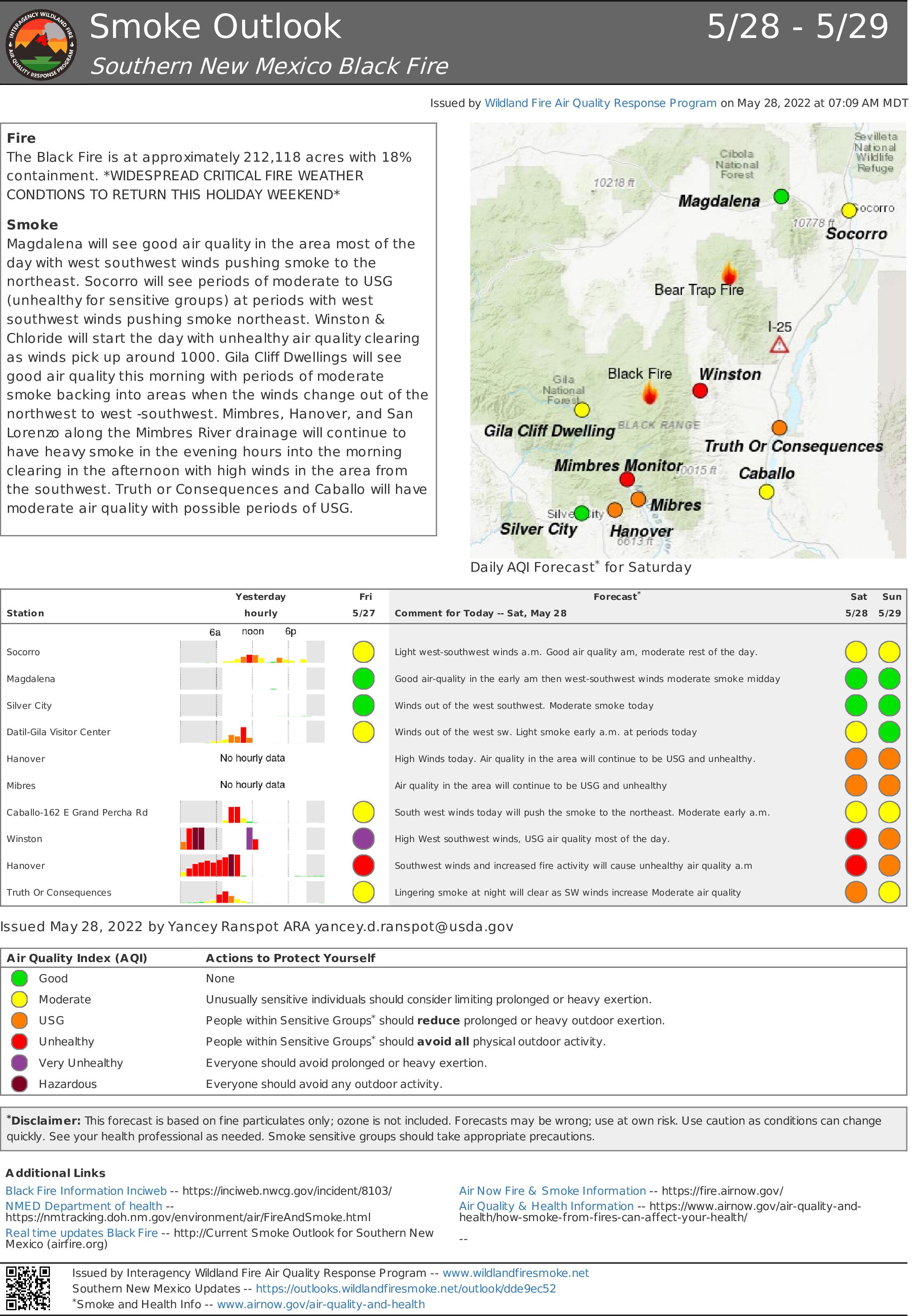
Smoke Outlook S New Mexico Black Fire 5282022
Related Incident:
Publication Type: Announcement
Smoke Outlook 5/28/22
- Magdalena will see good air quality in the area most of the day with west/southwest winds pushing smoke to the northeast.
- Socorro will see periods of moderate to unhealthy for sensitive groups air quality at periods with west/southwest winds pushing smoke to the northeast.
- Winston & Chloride will start the day with unhealthy air quality that will clear as winds pick up around 10:00am.
- Gila Cliff Dwellings will see good air quality this morning with periods of moderate smoke when the winds change direction.
- Mimbres, Hanover, and San Lorenzo along the Mimbres River will continue to have heavy smoke in the evening hours into the morning. The smoke will clear in the afternoon as high winds from the southwest push it out.
- Truth or Consequences and Caballo will have moderate air quality with possible periods of unhealthy air quality for sensitive groups.
- Silver City will see good to moderate air quality today.
Gila National Forest Revised Closure 5272022
Related Incident:
Publication Type: Closures
Gila National Forest Black Fire Emergency Closure(Revised - Effective 5/27/2022 12 p.m.)
EXEMPTIONS:
Pursuant to 36C.F.R.§261.50(e), the following persons are exempt from this Order:
1. Persons with a written Forest Service authorization specifically exempting them from the effect of this Order.
2. Any Federal, State, or local officer, or member of an organized rescue or firefighting force in the performance of an official duty.
AREA AND ROADS DESCRIBED:
All National Forest System lands, roads and trails within the exterior boundaries of the Gila National Forest as depicted on the attached map at Exhibit A Beginning at the intersection of Forest Road 150 (North Star Road) and New Mexico State Highway 59, encompassing the area south of Highway 59, headed east towards the intersection of Forest Road 955 (South Fence), headed northwest to Forest Trail 584 (Kennedy Canyon), continuing west on Forest Road 4052B, headed east through private and State Land just north of Adobe Ranch, connecting with Forest Trail 107 (House Mountain), continuing east to the intersection of Forest Road 4052S, intersecting with the Continental Divide trail, headed east to the intersection of Forest Trail 59 (Duck Canyon), intersecting with the eastern boundary of the Gila National Forest, then continuing south along the Forest Boundary to the intersection of Forest Trail 307 (Hermosa), headed west to the intersection of Forest Trail 123 (North Seco), headed west intersecting with Forest Trail 110 (Lake), proceeding southwest to the intersection of Forest Trail 79 (Black Range Crest), south to the intersection of Forest Trail 82 (Powderhorn Ridge), travelling west until Forest Road 151 (Powderhorn Ridge). The boundary continues along Forest Road 151 northwest until the intersection Highway 35, continuing west along Highway 35 until intersecting with Forest Road 150 (North Star Road), headed north west along Forest Road 150 to the intersection of Forest Trail 700 (Rocky Campground), turning into Forest Trail 95 (Brannon Park), continuing west to the intersection of Forest Trail 94 (Black Canyon), headed north to the intersection Forest Trail 708 (Tom Moore), continuing north to Forest Trail 713 (Link), continuing northeast along Forest Road 609, headed east to the beginning at the intersection of Forest Road 150 and 609, continuing north along Forest Road 150 to the intersection of Forest Road 150 and Highway 59.
The following roads are closed: Forest Road 150 is closed from Highway 35 north approximately 45 miles to the intersection of Forest Road 150. State Highway 59 is closed from the intersection Forest Road 150 to the intersection of State Highway 52. All roads and trails withing the closure are closed, including the section of the Continental Divide Trail listed in the order. Roads on state and private lands north of Adobe Ranch will remain open. Forest Road 151 will remain open.
Full release is available for download, below.
Black Fire Daily Update 5272022
Related Incident:
Publication Type: News
Firefighters working day and night to contain the Black Fire
Critical fire weather anticipated through the weekend
Daily Update 5/27/2022
Acres: 191,459 acres
Location: 31 miles NW of Truth or Consequences
Containment: 13%
Personnel: 784
Start Date: Friday, May 13, 2022
Cause: Human-caused, under investigation
Fuels: Timber and tall grass
Structures Lost: 2
Overview: The Black Fire has over 200 miles of perimeter and is growing by approximately 15,000 acres a day. This large and complex incident is burning across rugged, challenging terrain and firefighters are working day and night to contain it.
Fire Update: On Thursday, north winds kept the fire active. Overnight, crews focused on the northern perimeter of the fire by conducting firing operations to keep fire south of Highway 59 and west of Highway 52. These operations were conducted by both on-the-ground firefighters and Unmanned Aerial System (UAS) (drones) to assist in reducing severity of the main fire as it progresses through unburned fuels.
Today:Hot, dry, and breezy winds out of the west/southwest will generate an increase in fire activity. There is potential for individual and groups of trees to torch and spot in heavily timbered stands across the Black Fire. On the west side of the fire, crews will continue patrolling and securing containment lines, chipping slash and debris from fireline construction efforts and mopping up. To the north, fire activity will increase as it consumes unburned pockets of fuel. Crews on the east side of the fire will monitor several fingers of fire that have shown limited growth in the past few days and be prepared to keep the fire from moving farther east where needed. On the south end of the fire, crews will continue monitoring and responding to the fire as it burns near and into the Silver Fire scar. Firefighters will continue prepping firelines and aerial resources will assist with water drops when wind and weather conditions are safe to do so.
The Black Fire is actively burning in and around historic wildfire scars such as the Silver Fire, and prescribed fire burn areas. These areas are proving helpful and effective in reducing the intensity of the Black Fire by reducing the availability of fuels.
Weather: Winds across the Black Fire will become stronger out of the southwest by this afternoon with gusts ranging between 20-25mph. Temperatures will range between high 80s to low 90s, with minimum relative humidity falling into the mid to upper single digits. Gusty southwest winds and Red Flag conditions are anticipated through the weekend.
Evacuation Update: The following areas are under evacuation status in coordination with Grant, Catron, and Sierra counties. Please reference the Ready, Set, Go evacuation map.
GO – Area 1: The area runs from Burnt Cabin west along the south side of NM Highway 59 to the junction with Forest Road 150, then south along the east side of Forest Road 150 back to where it connects back to Area 2.
Area 2: Existing area 2 evacuations remain in place.
Area 4: Areas in Sierra County, from the Continental Divide Scenic Trail to just east of the Gila National Forest Boundary, including Hermosa and Mud Spring Mountain.
Area 5: Areas in Grant County, including the Forest Road 150 corridor 1.5 south of Tom Moore Trailhead.
Area 6: East of Forest Road 150 to the Continental Divide Scenic Trail.
Area 7: East of Forest Road 150 to the Continental Divide Scenic Trail.
Area 8: The area east of Forest Road 150 to the Gila National Forest Boundary, including the Continental Divide Scenic Trail, Victorio Park Mountain, Flagpole Mountain, and Pack Trail.
SET –
Area 1: Encompassing parts of Catron and Sierra Counties, including Beaverhead and Poverty Creek.
Area 3: Areas in Sierra County, including Winston and Chloride.
Area 6: The area west of Forest Road 150 in Grant County.
Area 7: The area west of Forest Road 150, including the Rocky Canyon Campground.
Area 8: The area west of Forest Road 150, beginning at the south end of Area 7, approximately four miles south, and approximately 9-10 miles west.
Area 9: From the north edge of Area 1, running north along the Forest Boundary four miles, then east approximately 24 miles then south back to the Area 1 set northern edge.
Area 11: The area three miles south of the existing Area 8 on the east side of Forest Road 150. This includes Cooney, McKnight Cabin, the Continental Divide Scenic Trail, and Kelly Mesa.
READY –
Area 10: From the northern edge of Area 9, north three miles, then east approximately 24 miles, then south three miles to the edge of Area 9.
Area 11: From the southern edge of Area 8, south three miles and then east to Forest Road 150. This includes V Cross Ranch, Lake Roberts, and Roberts Dip.
The sheriffs of Grant, Catron, and Sierra counties use the Ready, Set, Go evacuation program. For more information, visit https://www.emnrd.nm.gov/sfd/fire-prevention-programs/ready-set-go-new-mexico/
Road Closures: Highway 59 is closed at the junction with Forest Road 46, near Mud Hole. This allows Poverty Creek residents to access their property. Highway 59 is closed from Mud Hole west to the 59/150 intersection. Forest Road 150 is also closed where it intersects Mimbres Trail. I-25 and other state highways remain open. As a result of continued fire growth, a larger area closure is currently being identified to better ensure fire fighter and public safety.
Smoke Outlook: Low lying areas and drainages will see heavy smoke today. Tomorrow’s high winds will help clear smoke by mid-day. Magdalena and Socorro will see good air quality in the morning switching to moderate in the afternoon. Possible periods of USG (unhealthy for sensitive group) later in the afternoon, with light winds out of the west-southwest. Winston, Chloride, and surrounding areas will continue to see unhealthy conditions today with periods of hazardous in the mid-morning hours. Truth or Consequences will see periods of USG late in the day. Caballo will see periods of USG smoke throughout day. Gila Cliff Dwelling may see some periods of moderate and USG smoke with increased fire activity on the southwest part of the fire. Hanover will see USG conditions along the Mimbres river drainage later this afternoon. Silver City will have good air quality for the early am switching to moderate midday.
Aviation Restrictions: Airtankers, helicopters, water scoopers, and Unmanned Aerial Systems are assisting firefighters' suppression efforts. A 24-hour Temporary Flight Restriction (TFR) over the Black Fire restricts entry to non-fire aircraft, including civilian drones. Remember, if you fly, we can't.
Fire Restrictions:
- The Gila National Forest is under Stage 2 Fire Restrictions. Visit https://www.fs.usda.gov/alerts/gila/alerts-notices/?aid=73002 for more information.
- The New Mexico State Forester has implemented statewide fire restrictions. More information: https://www.emnrd.nm.gov/sfd/find-current-fire-restrictions/
More Information:
- New Mexico Fire information: https://nmfireinfo.com/
- Facebook: https://www.facebook.com/GilaNForest
- Twitter: https://twitter.com/gilanforest
Black Fire Daily Update 52622
Related Incident:
Publication Type: News
Firing Operations Along Turkey Creek Holding
Community Meeting Tonight at the Truth or Consequences Civic Center
Daily Update 5/26/2022
Acres: 179,539 acres
Location: 31 miles NW of Truth or Consequences
Containment: 13%
Personnel: 777
Start Date: Friday, May 13, 2022
Cause: Human-caused, under investigation
Fuels: Timber and tall grass
Structures Lost: 2
Overview: Personnel conducted firing operations along Turkey Creek Road to keep the fire south of State Highway 59 and west of State Highway 52. The rugged nature, inaccessible terrain, and the sheer size of the Black Fire makes gaining containment a slow process. The Black Fire encompasses more than 200 miles of containment lines, a distance that is farther than that of Truth or Consequences to Santa Fe.
Community Meeting: Thursday, May 26, 2022, at the Ralph Edward Civic Center 400 W 4th Street, Truth or Consequences, NM at 7:00 pm or watch it online at the Gila National Forest Facebook at https://www.facebook.com/GilaNForest. You do not need a Facebook account to view the meeting.
Fire Update: Overnight, personnel conducted firing operations northeast of the primary fire to keep the Black Fire south of Highway 59 and west of Highway 52. These operations were conducted in part by an Unmanned Aerial System (UAS) – also known as a drone, dropping spherical plastic balls that ignite when they hit the ground. The drone can cover more area in a shorter time than firefighters can on the ground, lowering the overall risk to pilots and firefighters. In combination with handlines, this firing operation created an area northeast of the fire to try to slow the fire's progression.
Today: Expect the Black Fire to continue to move north and south. Crews are patrolling and monitoring after yesterday's firing operations northeast of the main fire. South of the fire, a Structure Assessment Group is identifying homes, infrastructure, and outbuildings and ways to protect them. Crews are also preparing for firing operations south of the fire off Forest Road 150. Crews are scouting containment lines used on the Silver Fire in 2013 in hopes of utilizing them rather than creating new containment lines. Helicopters conducting bucket drops and super scooper aircraft using water from nearby lakes will be used on the north and south sides of the fire when needed. Fire activity on the east side of the fire has slowed over the past few days but will continue to progress into canyons as it finds vegetation to burn. Fire activity on the southeast corner of the fire near Hermosa has also slowed; however, crews continue to patrol the area for hotspots. Containment lines on the west side along Forest Road 150 continue to hold.
Weather: Temperatures will reach 90 degrees today. Winds will be lighter out of the west-southwest at 10 mph. Relative humidity will be 7%. This warming trend will bring critical fire weather as the week progresses.
Evacuation Update: The following areas are under evacuation status in coordination with Grant, Catron, and Sierra counties. Please reference the map.
GO – Area 1: The area runs from Burnt Cabin west along the south side of NM Highway 59 to the junction with Forest Road 150, then south along the east side of Forest Road 150 back to where it connects back to Area 2.
Area 2: Existing area 2 evacuations remain in place.
Area 4: Areas in Sierra County, from the Continental Divide Scenic Trail to just east of the Gila National Forest Boundary, including Hermosa and Mud Spring Mountain.
Area 5: Areas in Grant County, including the Forest Road 150 corridor 1.5 south of Tom Moore Trailhead.
Area 6: East of Forest Road 150 to the Continental Divide Scenic Trail.
Area 7: East of Forest Road 150 to the Continental Divide Scenic Trail.
Area 8: The area east of Forest Road 150 to the Gila National Forest Boundary, including the Continental Divide Scenic Trail, Victorio Park Mountain, Flagpole Mountain, and Pack Trail.
SET –
Area 1: Encompassing parts of Catron and Sierra Counties, including Beaverhead and Poverty Creek.
Area 3: Areas in Sierra County, including Winston and Chloride.
Area 6: The area west of Forest Road 150 in Grant County.
Area 7: The area west of Forest Road 150, including the Rocky Canyon Campground.
Area 8: The area west of Forest Road 150, beginning at the south end of Area 7, approximately four miles south, and approximately 9-10 miles west.
Area 9: From the north edge of Area 1, running north along the Forest Boundary four miles, then east approximately 24 miles then south back to the Area 1 set northern edge.
Area 11: The area three miles south of the existing Area 8 on the east side of Forest Road 150. This includes Cooney, McKnight Cabin, the Continental Divide Scenic Trail, and Kelly Mesa.
READY –
Area 10: From the northern edge of Area 9, north three miles, then east approximately 24 miles, then south three miles to the edge of Area 9.
Area 11: From the southern edge of Area 8, south three miles and then east to Forest Road 150. This includes V Cross Ranch, Lake Roberts, and Roberts Dip.
The sheriffs of Grant, Catron, and Sierra counties use the Ready, Set, Go evacuation program. For more information, visit https://www.emnrd.nm.gov/sfd/fire-prevention-programs/ready-set-go-new-mexico/
Road Closures: Highway 59 is closed from the 59/52 intersections west to the 59/150 intersection. Forest Road 150 is closed where it intersects Mimbres Trail. I-25 and other state highways remain open. As the fire continues to increase in size, a larger area closure is currently being identified that would better ensure fire fighter and public safety.
Smoke: Winston and surrounding area will see unhealthy conditions again today with periods of hazardous conditions in the mid-morning hours. Magdalena and Socorro will see good air quality in the morning, switching to moderate in the afternoon. Possible periods of Unhealthy for Sensitive Groups (USG) later in the afternoon with light winds out of the west-southwest. Truth or Consequences will see smoke impacts early this morning. Increased fire activity will produce periods of USG in the area late in the day. Low lying areas and drainages will see increased smoke. Caballo will see periods of USG smoke throughout the day. Gila Cliff Dwelling may see some periods of USG smoke with increased fire activity on the southwest part of the fire. Hanover will see USG smoke along the Mimbres river drainage later in the afternoon. Increased fire activity will bring periods of Unhealthy for Sensitive Groups (USG) south of the fire. Silver City will have good air quality for the early morning, switching to moderate mid-day. More information is available at https://outlooks.airfire.org/outlook.
Aviation Restrictions: Airtankers, helicopters, water scoopers, and Unmanned Aerial Systems are assisting firefighters' suppression efforts. A 24-hour Temporary Flight Restriction (TFR) over the Black Fire restricts entry to non-fire aircraft, including civilian drones. Remember, if you fly, we can't.
Fire Restrictions:
The Gila National Forest is under Stage 2 Fire Restrictions.
Visit https://www.fs.usda.gov/alerts/gila/alerts-notices/?aid=73002 for more information. The New Mexico State Forester has implemented statewide fire restrictions. More information: https://www.emnrd.nm.gov/sfd/find-current-fire-restrictions/
More Information: Inciweb: https://inciweb.nwcg.gov/incident/8103/ New Mexico Fire information: https://nmfireinfo.com/ Facebook: https://www.facebook.com/GilaNForest Twitter: https://twitter.com/gilanforest
Smoke Report for 5262022
Related Incident:
Publication Type: Announcement
Heavy Smoke Day
Increased fire activity yesterday and light winds from south/southwest means we will see smoke impacts this morning that will linger. Expect little to no relief from smoke today in the outlook area. Low lying areas and drainages will see heavy smoke today.
- Winston, Chloride and the surrounding area will see unhealthy conditions again today with periods of hazardous air quality in the mid-morning hours.
- Magdalena and Socorro will see good quality in the morning, switching to moderate in the afternoon.
- Truth or Consequences will see smoke impacts in the morning. Increased fire activity in the afternoon will produce periods of Unhealthy for USG air quality late in the day. Low lying areas and drainages will see increased smoke.
- Silver City will have good air quality for the early a.m. switching to moderate midday.
- Caballo will see periods of USG smoke throughout the day.
- Gila Cliff Dwelling may see some periods of USG smoke.
- Hanover will see USG smoke along the Mimbres river drainage later in the afternoon.
* USG=Unhealthy for Sensitive Groups
More Info: Southern New Mexico Smoke Outlook