
Black Fire Smoke Update for 5212022
Related Incident:
Publication Type: Announcement
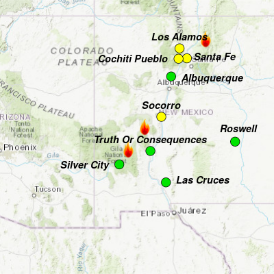
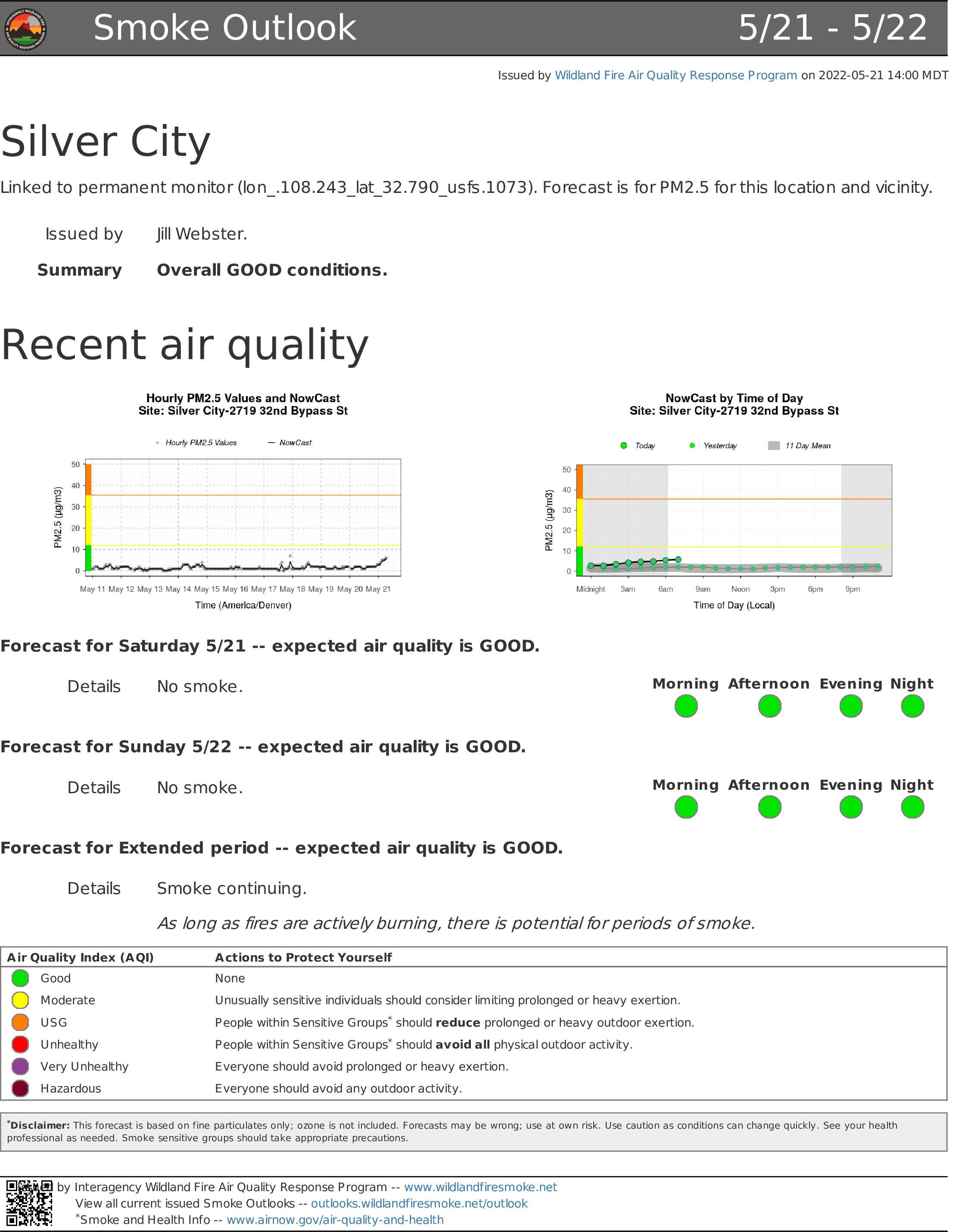
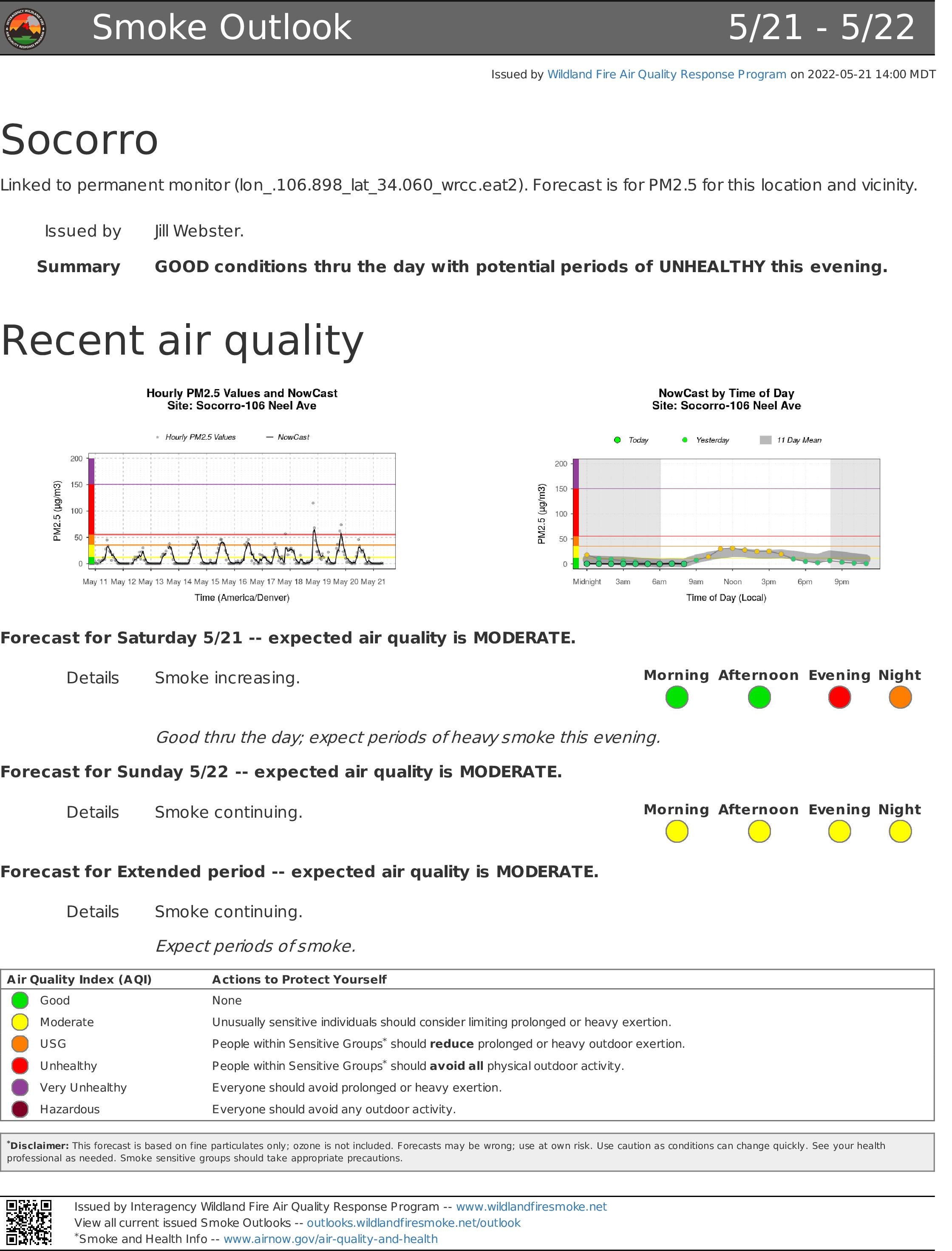
Gusty winds will disperse smoke today, so most of the area will have overall 'Good' conditions throughout the day. However, Truth Or Consequences and Socorro may see periods of smoke and 'Unhealthy' conditions this afternoon.
Silver City and Las Cruces should maintain 'Good' air quality.
The Black Fire is producing heavy smoke that can be seen from all over the state. The smoke is drifting to the east affecting much of New Mexico before moving northward into Texas.
Visit https://outlooks.wildlandfiresmoke.net/outlook/63a6f2d8? for additional information.
Black Fire Daily Update 52122
Related Incident:
Publication Type: News
Crews continue constructing fireline as some containment is achieved on the Black Fire
Daily Update 5/21/2022
Acres: 120,785 acres (Friday Infrared Flight)
Location: 31 miles NW of Truth or Consequences
Containment: 4%
Personnel: 615
Start Date: Friday, May 13, 2022
Cause: Human caused, under investigation
Fuels: Timber and tall grass
Announcement:
Fire Update: On Friday, the Black Fire continued to show active fire behavior with wind-driven uphill runs and spreading to the north, east, and south. The east side of the Continental Divide continued to show most activity overnight while fire continues to move south through previous fire footprints, including the Silver Fire burn scar. Firefighters also continued to scout and prep containment lines and crews continued to actively assess the number of structures threatened.
Today, the fire is expected to continue exhibiting active, terrain-driven fire behavior. Fire will move in all directions, including on the east side of the Continental Divide from the evening, through the overnight hours and until just before sunrise, as well as movement through canyons and surrounding terrain to the north and south where fuels are available. A combination of hand crews, aerial ignitions, and aerial resources dropping water and retardant will be used to strengthen firelines and slow the fire’s rate of spread where effective.
Along the western perimeter, crews will monitor the fire and continue working to secure containment lines, with mop up occurring on the southwestern side. Further north, fire personnel will continue to prep fireline and begin constructing direct and indirect line along Forest Road 150, south to Rocky Point Trail. To the east, firefighters will conduct mop up and continue prepping the Titanic Road.
Crews will continue conducting structural assessments and taking point protection actions, such as installing sprinkler systems to protect private property, critical infrastructure, and other values at risk. Firefighters are working day and night to contain the Black Fire. This work is arduous and slow going.
Evacuations: Several areas have been evacuated or are in evacuation readiness. The sheriffs of Grant, Catron, and Sierra counties are using the Ready, Set, Go program to notify residents of evacuation status. For detailed information on Ready, Set, Go! New Mexico, visit https://www.emnrd.nm.gov/sfd/fire-prevention-programs/ready-set-go-new-mexico/.
In coordination with Grant, Catron, and Sierra counties, the following areas are under evacuation status:
GO – Area 2: Encompasses part of Catron and Sierra Counties, including Round Mountain, Diamond Bar Ranch, Me Own Work Center, Links Ranch, Lookout Mountain, and Sugar Loaf Peak
GO – Area 4: Areas in Sierra County, including Hermosa and Mud Spring Mountain
SET – Area 1 Encompasses parts of Catron and Sierra Counties, including Beaverhead and Poverty Creek
GO – Area 5: Areas in Grant County, including 150 corridor 1.5 south of Tom Moore Trailhead
SET – Area 3: Areas in Sierra County, including Winston and Chloride
SET – Area 6: Areas in Grant County, including the Dispersed area south of Black Canyon Access point along the 150 corridor
READY – Area 7: Areas in Grant County, including 150 corridor Rocky Point CDST and Rocky Canyon Campground
Evacuation maps can be viewed at: https://inciweb.nwcg.gov/incident/8103/
Weather: Today will be sunny and hazy as southwest to westerly winds continue across the fire area with gusts up to 25mph until this evening. Temperatures will decrease slightly to the mid-70s and relative humidity will increase slightly to 12-15%. This cooling trend and lighter winds will continue through the weekend.
Road Closures: Highway 59, is closed from the 59/52 intersections west to the 59/150 intersection, as well as portions of Forest Road 150 (aka North Star Mesa Road or Wall Lake Road) to through traffic. I-25 and other state highways remain open.
Smoke: Gusty winds will disperse smoke today, so most of the area will have overall 'Good' conditions throughout the day. However, Truth Or Consequences and Socorro may see periods of smoke and 'Unhealthy' conditions this afternoon. Silver City and Las Cruces should maintain 'Good' air quality. The Black Fire is producing heavy smoke that can be seen from all over the state. The smoke is drifting to the east affecting much of New Mexico before moving northward into Texas. Visit https://outlooks.wildlandfiresmoke.net/outlook/63a6f2d8? for additional information.
Aviation Restrictions: Airtankers, helicopters, and water scoopers are assisting firefighters’ suppression efforts. There is a Temporary Flight Restriction (TFR) over the Black Fire to allow official aviation resources to operate safely.
Fire Restrictions: The Gila National Forest entered Stage 2 Fire Restrictions at 8 a.m., Thursday, May 19, 2022. Visit https://www.fs.usda.gov/alerts/gila/alerts-notices/?aid=73002. The New Mexico State Forester has implemented statewide fire restrictions. Information is available at https://www.emnrd.nm.gov/sfd/find-current-fire-restrictions/.
More Information:
Inciweb: https://inciweb.nwcg.gov/incident/8103/
New Mexico Fire information: https://nmfireinfo.com/
Facebook: https://www.facebook.com/GilaNForest
Twitter: https://twitter.com/gilanforest
Black Fire Update 52022
Related Incident:
Publication Type: News
Crews Continue Prepping Fire Line and Red Flag Warning Continues on Black Fire;
Community meeting scheduled for tonight at 7 p.m. in Truth or Consequences
Daily Update 5/20/2022
Acres: 104,969 acres
Location: 31 miles NW of Truth or Consequences
Containment: 0%
Personnel: 475
Start Date: Friday, May 13, 2022
Cause: Unknown, under investigation
NOT ignited by prescribed fire
Fuels: Timber and tall grass
Announcement: The public is invited to the community meeting tonight at 7 p.m. at the Ralph Edward Civic Center, 400 West 4th St, Truth or Consequences, NM 87901. It will also be live-streamed on the Gila National Forest Facebook page at https://www.facebook.com/GilaNForest. You do not need a Facebook account to view the meeting.
Fire Update: On Thursday, the Black Fire showed active fire behavior with uphill runs and spotting on the north, east, and south flanks. The fire's east flank continues to show more activity from the evening hours overnight to just before sunrise. Fire personnel are actively assessing the number of structures threatened.
A Red flag warnings remain in effect today, with high winds in the forecast. The fire is moving east, northeast, and southeast. Firefighters will focus today's operations on prepping and constructing direct and indirect control lines and using point protection tactics to protect private property, critical infrastructure, and other values. Hand ignitions are being used to increase fire line depth where needed.
Evacuations: Several areas have been evacuated or are in evacuation readiness. The sheriffs of Grant, Catron, and Sierra counties are using the Ready, Set, Go program to notify residents of evacuation status. For detailed information on Ready, Set, Go! New Mexico, visit https://www.emnrd.nm.gov/sfd/fire-prevention-programs/ready-set-go-new-mexico/.
In coordination with Grant, Catron, and Sierra counties, the following areas are under evacuation status:
GO – Area 2: Encompasses part of Catron and Sierra Counties, including Round Mountain, Diamond Bar Ranch, Me Own Work Center, Links Ranch, Lookout Mountain, and Sugar Loaf Peak
GO – Area 4: Areas in Sierra County, including Hermosa and Mud Spring Mountain SET – Area 1 Encompasses parts of Catron and Sierra Counties, including Beaverhead and Poverty Creek
GO – Area 5: Areas in Grant County, including 150 corridor 1.5 south of Tom Moore Trailhead
SET – Area 3: Areas in Sierra County, including Winston and Chloride
SET – Area 6: Areas in Grant County, including the Dispersed area south of Black Canyon Access point along the 150 corridor
READY – Area 7: Areas in Grant County, including 150 corridor Rocky Point CDST and Rocky Canyon Campground
Evacuation maps can be viewed at: https://inciweb.nwcg.gov/incident/8103/
Weather: A low pressure system will move out of the Great Basin, causing Red Flag conditions on the Black fire today. Highs will be 78 to 82 with southwest to west winds around 20 mph and gusts up to 35-40 mph. Winds are expected to decrease Saturday with cooler temperatures.
Road Closures: County Road 59, between Beaverhead and the 59/52 junction, and portions of Forest Road 150 (aka North Star Mesa Road or Wall Lake Road). I-25 and other state highways remain open.
Smoke: The Black Fire produces heavy smoke that can be seen from all over the state. The smoke is drifting to the east affecting much of New Mexico before moving northward into Texas. Visit https://fire.airnow.gov/ for additional information.
Aviation Restrictions: Airtankers, helicopters, water scoopers are assisting with fire suppression efforts. There is a Temporary Flight Restriction (TFR) over the Black Fire to allow official aviation resources to operate safely. The use of drones by members of the public within a Temporary Flight Restriction is prohibited. Firefighting aircraft cannot fly if any aircraft, including drones, violate the restriction, it also poses a danger to firefighters on the ground by leaving them without aerial support.
Fire Restrictions: The Gila National Forest entered Stage 2 Fire Restrictions, effective at 8:00 a.m., Thursday, May 19, 2022. Visit https://www.fs.usda.gov/alerts/gila/alerts-notices/?aid=73002. The New Mexico State Forester has implemented statewide fire restrictions. Information is available at https://www.emnrd.nm.gov/sfd/find-current-fire-restrictions/.
More Information:
Inciweb: https://inciweb.nwcg.gov/incident/8103/
New Mexico Fire information: https://nmfireinfo.com/
Facebook: https://www.facebook.com/GilaNForest
Twitter: https://twitter.com/gilanforest
Black Fire Community Meeting Tonight May 20 2022
Related Incident:
Publication Type: Announcement
The public is invited to the community meeting tonight at 7 p.m. at the Ralph Edward Civic Center, 400 West 4th St, Truth or Consequences, NM 87901. It will also be live-streamed on the Gila National Forest Facebook page at https://www.facebook.com/GilaNForest.
Please note, you do not need a Facebook account to view the meeting.
ASL and CART services will be provided.
Black Fire Health and Safety Closure Order Number 03060522004
Related Incident:
Publication Type: Closures
Closure Map (see attachment)
Gila National Forest - Wilderness & Black Range Ranger District
Black Fire Health and Safety Closure - Order Number: 03-06-05-22-004, Exhibit A
Black Fire Daily Update 51922
Related Incident:
Publication Type: News
Active Fire Behavior Continues Across the Black Fire with Red Flag Warning Issued
Community meeting scheduled for 7 p.m. Friday in Truth or Consequences
Daily Update 5/19/2022
Acres: 93,014 acres (Infrared flight Wednesday night)
Location: 31 miles NW of Truth or Consequences
Containment: 0%
Personnel: 450
Start Date: Friday, May 13, 2022
Cause: Unknown, under investigation
Fuels: Timber and tall grass
Announcement: A public meeting will be hosted on Friday at 7 p.m. at the Ralph Edward Civic Center, 400 West 4th St, Truth or Consequences, NM 87901.
Fire Update: On Wednesday, the Black Fire showed active fire behavior with upslope runs and crown fire in the tops of trees. Fire personnel were able to construct handline around the southwest side of the fire. They scouted potential fireline locations and constructed direct and indirect fireline, using hand ignitions to strengthen firelines where needed. Heavy equipment, including bulldozers, also assisted with building fireline within the Turkey Run area on the north side of the fire. Aerial resources assisted extensively, dropping water to assist firefighters on the ground and slow the fire’s rate of spread.
Today, firefighters will continue to work on Forest Road 150 (aka North Star Mesa Road or Wall Lake Road), located on the west side of the fire, from the Middle Mesa area to the south as well as from Diamond Creek north towards Beaverhead. Crews will assess structures threatened across the fire area, construct direct and indirect control lines and use point protection tactics. To date, no structures are known to be damaged or destroyed. Firefighters on the eastern side will scout and construct fireline when and where they can safely work and there is a good chance of success.
The Black Fire continues to burn in extremely dry timber and tall grass fuels. The fine fuels are very high across the fire due to last year’s robust monsoons and is a contributing factor to high rates of spread through previously burned and unburned areas. The fire is expected to spread rapidly where fuels and topography align.
Evacuations: Several areas have been evacuated or are in evacuation readiness. The sheriffs of Grant, Catron and Sierra counties are using the Ready, Set, Go program to notify residents of evacuation status. For detailed information on Ready, Set, Go! New Mexico, visit https://www.emnrd.nm.gov/sfd/fire-prevention-programs/readyset-go-new-mexico/.
In coordination with Grant, Catron and Sierra counties, the following areas are under evacuation status:
In Grant County:
GO: Starting from the Tom Moore Canyon Trailhead, nine miles to the west, south two miles, east to the Continental Divide Trail, and north two miles.SET: Starting from the Tom Moore Canyon Trailhead, five miles to the west, three miles south, east to the Continental Divide Trail, and north three miles.READY: Starting at the Tom Moore Trailhead, nine miles to the west, south five miles, east to the Continental Divide Trail, and north five miles.
In Catron and Sierra counties:GO: Starting three miles south of Beaverhead, five miles to the west, south to the Catron and Sierra County line.SET: From Beaverhead, three miles south to Kemp Mesa, four miles west, six miles east to the Catron County line, and three miles north.READY: The area starting at the Grant County line south seven miles and east from the Continental Divide Trail approximately eight miles.
Sierra County:GO: Residents in the Mud Spring Mountain area and the community of Hermosa. SET: The area starting from one mile north of Lookout Mountain Trailhead, north seven miles, west to the Sierra County line and east to County Road 59. Starting from the Sierra County line north 12 miles, three miles east of the Continental Divide Trail, and west four miles.
Evacuation maps can be viewed at: https://inciweb.nwcg.gov/incident/8103/
Weather: A Red Flag Warning is in effect today and tomorrow. Relative humidity will drop below 10% with limited overnight humidity recovery. Temperatures will continue to be above average, and winds will range from 15-20 mph with 25-30 mph gusts.
Road Closures: Portions of Forest Road 150 (aka North Star Mesa Road or Wall Lake Road) is closed to the public. I-25 and other state highways remain open.
Smoke: The Black Fire produces heavy smoke that can be seen from all over the state. The smoke is drifting to the east affecting much of New Mexico before moving northward into Texas. Visit https://fire.airnow.gov/ for additional information.
Aviation Restrictions: Airtankers and helicopters are available to assist for with fire suppression efforts. There is a Temporary Flight Restriction (TFR) over the Black Fire. Firefighting aircraft cannot fly if any aircraft, including drones, violates the restriction and poses a danger to firefighters on the ground by leaving them without aerial support.
Fire Restrictions: The Gila National Forest entered Stage 2 Fire Restrictions, effective at 8:00 a.m., Thursday, May 19, 2022. The New Mexico State Forester has implemented statewide fire restrictions. Information is available at https://www.emnrd.nm.gov/sfd/find-current-fire-restrictions/.
More Information:
Inciweb: https://inciweb.nwcg.gov/incident/8103/
New Mexico Fire information: https://nmfireinfo.com/
Facebook: https://www.facebook.com/GilaNForest
Twitter: https://twitter.com/gilanforest
Black Fire Update for 51722
Related Incident:
Publication Type: News
Location of Origin: 24 miles north of Mimbres in the Gila National Forest
Start date: May 13, 2022, 9 p.m. MDT
Size: 56,132
Percent Contained: 0%
Cause: Undetermined
Resources Assigned: 153 personnel 11 crews, 3 helicopters, 5 engines, 1 water tender
Closures: Partial closure in effect for portions of Forest Road 150, Forest Service Trails 708, 713, 716
Safety: Please use extreme caution when using a source of spark or fire. With very low humidity and gusty winds, any new wildfire start can grow very quickly.
TODAY
Firefighters will face another challenging day on the Black Fire with continued high temperatures and low humidity. The fire, burning in the Gila National Forest has grown to 56,132 acres and is expected to see significant growth again today. Relative humidity has been extremely low, with no recovery after sundown, resulting in active fire behavior through the night.
The Black Fire made a significant run to the east yesterday from Forest Road 150 and crossed the Black Range Crest at Diamond Peak. On the west side of FR 150, crews are having success constructing fireline. The fire remains north of Black Canyon.
A precautionary evacuation of Lookout Mountain took place yesterday and evacuations for several in-holdings north of the Aldo Leopold Wilderness Boundary were recommended. Poverty Creek and in-holdings south of HWY 59 were placed under Ready-Set evacuation levels.
The Southwest Area Type 2 Team 5 will be taking over management of the firefighting effort tomorrow morning, May 18.
As of May 5, the Gila National Forest has implemented STAGE 1 fire restrictions across the entire forest. More information can be found at https://go.usa.gov/xudPe
CLOSURES
The fire has crossed Forest Service Road 150 north of Forest Trail 716, east of Forest Trail 713 and south of 609 Links Ranch Road. As a result, a partial closure is in effect for portions of Forest Road 150 and for Forest Service Trails 708, 713, and 716.
WEATHER
Exceptionally dry weather continues today with relative humidity of 2-5 percent. Hazy skies in the Rio Grande Valley and Lincoln National Forest should lift by midday, with light southwest winds helping to clear up smoke.
SUMMARY
The Black Fire started May 13, 2022, at 9 p.m. MDT. It is located 24 miles north of Mimbres in a wilderness area on the Gila National Forest. The cause is under investigation.
Black Fire Update for 51622
Related Incident:
Publication Type: News
Location of Origin: 24 miles north of Mimbres in the Gila National Forest
Start date: May 13, 2022, 9 p.m. MDT
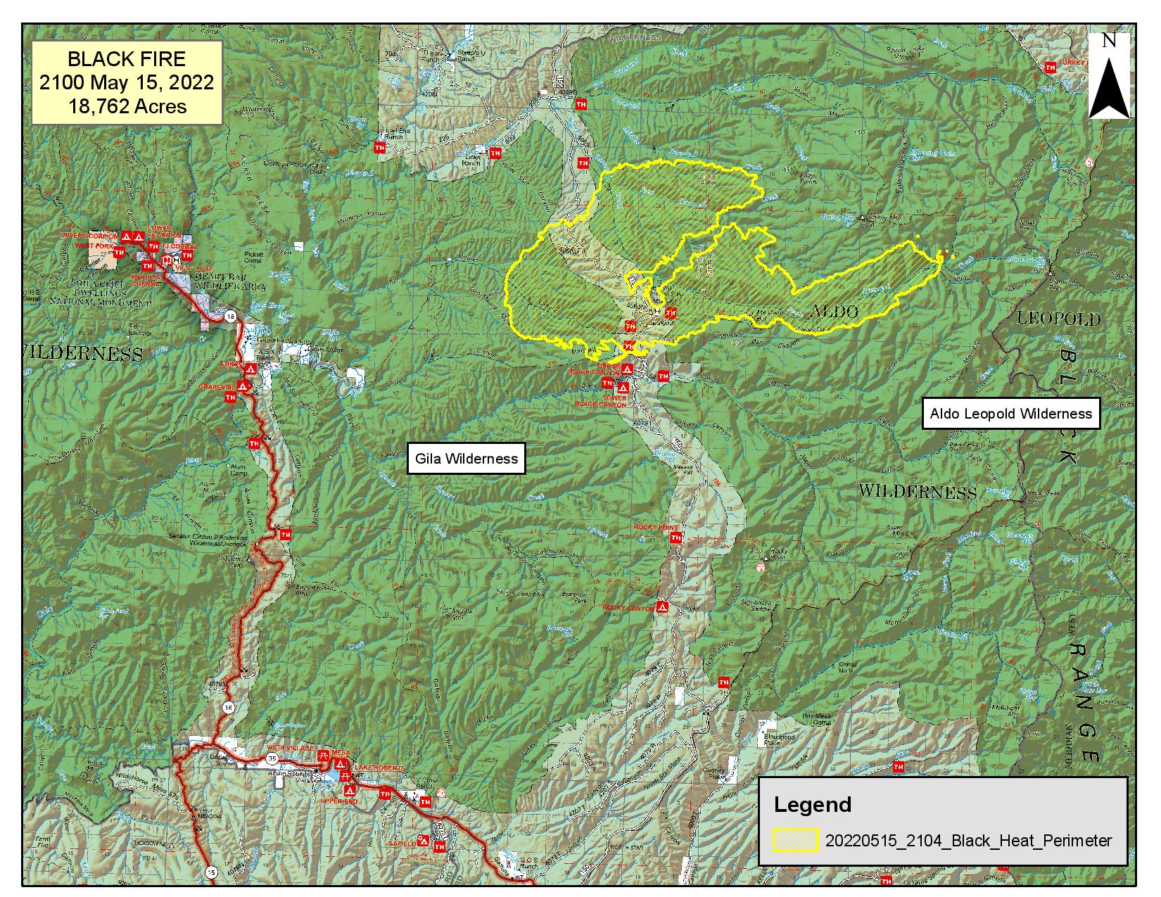
Size: 18,762
Percent Contained: 0%
Cause: Undetermined
Resources Assigned: 141 personnel, 2 crews, 2 helicopters, 7 engines, 1 water tender
Closures: Partial closure in effect for portions of Forest Road 150, Forest Service Trails 708, 713, 716
Safety: Please use extreme caution when using a source of spark or fire. With very low humidity and gusty winds, any new wildfire start can grow very quickly.
The Black Fire has grown to 18,762 acres and is expected to have another large growth day, due to continued low humidity and wind. The fire that had spread to the east of Forest Road 150 near Meown and a new spot fire north of Meown have established in South Diamond Creek, with both making significant runs yesterday to the east and north. Due to extremely low humidity active burning continued through the night. The fire is expected to continue to burn towards the Black range crest in the Sheep Mountain and Diamond Peak area. A Southwest Type 2 Incident Management Team has begun mobilizing to take over management of the firefighting operation.
Crews’ focus today will be containing fire west of Forest Road 150 in the Links ranch area and securing the southern edge, keeping the fire out of Black Canyon. Large volumes of smoke and columns will be visible in the Rio Grande Valley especially in the nearby communities of Winston and Poverty Creek. Smoke is also visible from the Mimbres Valley, Gila River Valley and Silver City.
The fire is 100% suppression strategy utilizing direct, indirect and point protection strategies with ground and aerial resources.
As of May 5, the Gila National Forest has implemented STAGE 1 fire restrictions across the entire forest. More information can be found at https://go.usa.gov/xudPe
CLOSURES
The fire has crossed Forest Service Road 150 north of Forest Trail 716, east of Forest Trail 713 and south of 609 Links Ranch Road. As a result, a partial closure is in effect for portions of Forest Road 150 and for Forest Service Trails 708, 713, and 716.
WEATHER
Above-normal temperatures and critically low relative humidity are expected to continue today. Breezy southwest winds are expected to return but are forecast to remain below critical thresholds. Humidity has remained very low overnight, resulting in increased fire activity overnight.
Black Fire Update for May 15 2022
Related Incident:
Publication Type: News
Firefighters will experience the hottest weather of the season today with temperatures reaching 90-degrees. Winds are expected to be a sustained 21 mph with gusts of 31 mph.
With these weather conditions and exceptionally dry conditions, active burning is expected today on the Black Fire in the Gila National Forest. The fire, which was discovered Friday evening, has grown to 1,147 acres. It is located off Forest Service Road 150, north of Black Canyon, west of the Meown Work Center, and 24 miles north of Mimbres. The cause is under investigation.
Today a Type 3 team began managing the firefighting operations. More than 120 fire personnel are working to contain the fire, which is currently at zero percent containment.
Fire managers are using a confine and contain strategy to corral the flames, using man-made and natural barriers to stop the fire and also taking steps to protect nearby private inholdings and infrastructure. This strategy has the highest probability of success while minimizing risk to firefighters.
Forest Road 150 is closed between Meason Park to the intersection of 150 and Diamond Creek.
The Black Fire is burning in timber, and tall grass. Above normal temperatures and critically low relative humidity are expected to continue through the weekend and into next week. There is little recovery of humidity at night, resulting in continued active burning overnight.
USFS responding to fire in Gila National Forest
Related Incident:
Publication Type: News
The U.S. Forest Service is responding to a fire in the Gila National Forest.
The Black Fire was discovered Friday evening, May 13, at 9:30 p.m. and is located off the NorthStar, FSR 150, road, west of Meown workstation and north of Black Canyon. It is estimated at about 1,041 acres and burning in grass, juniper mesas, and occasional pine stringers in the Gila wilderness area. Fifty-five firefighters are on-scene with more resources on order.
Today, firefighters are expecting to see high temperatures of 88 degrees, low humidity, and light variable wind.
The cause of the fire is under investigation.
Stage 1 Fire restrictions remain in effect on the Gila National Forest to reduce the risk of human-caused wildfires.
Under Stage 1 fire restrictions, igniting, building, maintaining, or using a fire, including charcoal and briquettes is allowed only inside a fire structure provided by the Forest Service within designated areas. Smoking is allowed only within an enclosed vehicle or building, a developed recreation site, or while stopped in an area at least three feet in diameter that is clear of all flammable material.
For further information regarding the Black Fire, please call our fire information line at 662-318-3431.