
HPCC Burn Scar Flash Flood Potential Very High for June 8
Related Incident: Hermits Peak and Calf Canyon BAER
Publication Type: News
Hermits Peak-Calf Canyon Burn Scar Flash Flood Potential Very High on Wednesday, June 8, 2022
SHARING IMPORTANT INFORMATION FROM THE NATIONAL WEATHER SERVICE—ALBUQUERQUE NM:
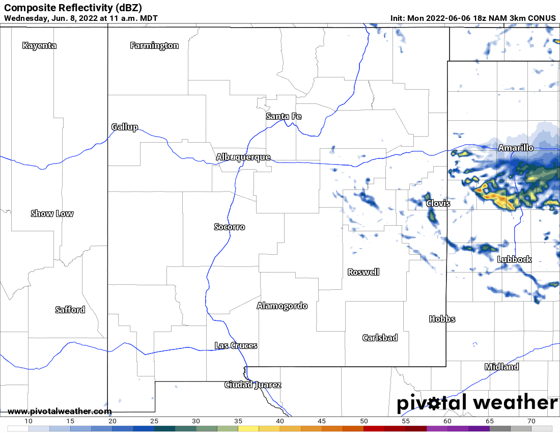
A Flash Flood Watch has been posted: WWA Summary for Flood Watch Issued by ABQ (weather.gov)
We anticipate some additional advisories/warnings on Wednesday, June 8, 2022.
The National Weather Service (NWS) briefing is publicly available at https://www.weather.gov/media/abq/Briefings/weeklyweatherbriefing.pdf
Flooding Preparedness NWS Website:
Emergency Preparedness: Flooding (weather.gov)
NWS is closely watching thunderstorm trends for Tuesday afternoon, June 7, but especially on Wednesday, June 8, which is the bigger day of concern.
Moisture will be strongly replenished starting Tuesday evening/night into early Wednesday, June 8.
The coverage of thunderstorms near and within the Hermits Peak-Calf Canyon fire perimeter Wednesday afternoon, June 8, is likely to be the greatest that we have seen thus far.
Most probable window is 11:00am through 7:00pm.
Real concerns for flash flooding from any thunderstorm during this timeframe is given very high potential for 0.25” in the span of 15-30 minutes.
This is not the monsoon pattern just yet but more the effects of backdoor cold fronts flushing in higher moisture from the east. The area does dry out again Thursday-Saturday, June 9-June 11.
ATTACHED AT THE BOTTOM OF THIS PAGE IS A LINK TO A GIF MOVING NWS MAP
Phase 2 BAER Assessment of Hermits PeakCalf Canyon Fires Begins
Related Incident: Hermits Peak and Calf Canyon BAER
Publication Type: News
FOREST SERVICE BAER TEAM BEGINS PHASE 2
POST-FIRE ASSESSMENT OF HERMITS PEAK AND CALF CANYON FIRES
The Santa Fe National Forest (SFNF) Burned Area Emergency Response (BAER) team has begun its Phase 2 assessment of National Forest System (NFS) lands impacted by the Hermits Peak and Calf Canyon Fires on the east side of the Sangre de Cristo Mountains. Due to the large size and ongoing active fire behavior on these two wildfires, the BAER team divided the burned area into phases for assessment and analysis, beginning in the cooler areas of the fire.
The team’s Phase 1 assessment of the Headwaters Gallinas River and Tecolote Creek watersheds is being finalized now, and an executive summary will be shared with the public and posted to the BAER team’s InciWeb page at https://inciweb.nwcg.gov/incident/8104/. Phase 2 BAER assessment will cover the northern area of the fire, including the Sapello River Watershed, Upper Mora Watershed and portions of Embudo Creek Watershed.
After a large wildfire, special actions may be necessary to provide for public and community safety and protect critical natural and cultural resources from post-fire events like soil erosion and flooding. The BAER program uses ground and aerial surveys, satellite imagery and computer models to evaluate conditions and recommend emergency treatments to protect NFS values at risk from further damage.
BAER teams focus on emergency actions necessary to protect human life and safety, property, and natural and cultural resources, including affected watersheds. BAER assessments identify unacceptable risks on federal lands from post-fire threats and help land managers prepare burned areas for potential threats from rainstorms. Burned areas often experience increased soil erosion and runoff from rainstorms.
The Forest Service BAER team assessing the Hermits Peak and Calf Canyon Fires consists of hydrologists, soil scientists, road engineers, biologists, archaeologists, recreation specialists, and geographic information system (GIS) specialists. The first step in the BAER assessment process is taking pre-fire and post-fire satellite imagery and data to produce a soil burn severity map, which provides baseline information on changed watershed conditions and potential watershed impacts from the fire. The BAER team’s assessment report will include recommended emergency stabilization treatments and actions.
The BAER team will coordinate and share information from its assessment with other federal agencies, including the Natural Resources Conservation Service (NRCS), National Weather Service (NWS) and US Geological Survey (USGS) as well as state agencies and local counties and municipalities who work with adjacent and downstream private homeowners, landowners, and businesses to prepare for potential post-fire flooding and debris flow impacts. NRCS is a federal agency that has post-fire responsibilities on private lands both within and downstream of burned areas.
Homes or businesses that could be impacted by flooding from federal land that result from wildfires may be eligible for flood insurance coverage from the National Flood Insurance Program (NFIP). Information about NFIP is available through FEMA at www.fema.gov/national-flood-insurance-program, or www.floodsmart.gov/wildfires. Other flood preparedness information is available at www.ready.gov/floods at www.floodsmart.gov/.
BAER SAFETY MESSAGE: Everyone near and downstream from the burned areas should remain alert and stay updated on weather conditions that may result in heavy rains and increased water runoff. Flash flooding may occur quickly during heavy rain events – be prepared to act. Current weather and emergency notifications can be found at the National Weather Service website: www.weather.gov/abq/.
# # #Phase I BAER Assessment Team Specialists Evaluate Burned Area
Related Incident: Hermits Peak and Calf Canyon BAER
Publication Type: News
PHASE I BAER ASSESSMENT TEAM SPECIALISTS EVALUATE THE HERMITS PEAK-CALF CANYON FIRE FOR FLOODING RISKS
While many wildfires cause little damage to the land and pose few threats to natural resources and people downstream, some fires create situations that require special efforts to prevent additional damage after wildfires. Loss of vegetation exposes soil to erosion; water runoff may increase and cause flooding, sediments may move downstream and damage houses or fill reservoirs and put endangered species and community water supplies at-risk.
The Forest Service (USFS) Burned Area Emergency Response (BAER) program works on USFS lands with the goal of keeping National Forest (NF) visitors and employees safe while recreating and working. BAER team assessments focus on emergency actions that are necessary to protect human life and safety, property, critical cultural resources, and critical natural resources such as soil productivity, hydrologic function, and water quality. Emergency actions are intended to minimize any further damage during rainstorm events.
Water is one of the most important natural resources flowing from forests. The Forest Service manages the largest single source of water in the U.S. with about 18% originating from 193 million acres of National Forest System (NFS) lands. A network of water and watershed resource specialists support stewardship efforts at all levels of the organization to promote healthy, sustainable watersheds fundamental to ecosystems and people.
A watershed is the drainage area where water from rain or melting snow and ice drains downhill into a body of water such as a river, stream, lake, reservoir, pond, estuary, wetland, aquifer, sea, or ocean.
BAER hydrologists, soil scientists and watershed resource specialists are currently assessing the condition and response of the watersheds within the Hermits Peak-Calf Canyon burned areas. Other BAER specialists evaluate other critical values that could be at risk during major rainstorm events such as NFS roads and trails, campgrounds, and other NFS infrastructures.
Photo 1: BAER specialists overview of the Headwaters of Gallinas Watershed from the top of Johnson Mesa.

At this location, BAER Hydrologists Paul Brown, Edgar Martinez, and Alex Makic were overlooking the burned watershed and its overall drainage system as data in their evaluation of its post-fire condition and response.
Photos 2 & 3: Overview look of Hermits Peak-Calf Canyon burned watersheds.


BAER soil scientists evaluate the burned watersheds to determine whether the soil is hydrophobic – aka repels water. This is important because the amount of hydrophobicity is an important component to determining how much increased water runoff we can expect after a fire. Hydrophobicity is the physical property of a molecule that is seemingly repelled from a mass of water and is considered when mapping watershed response to rainstorms after a wildfire.
Photo 4: BAER soil specialist trainee Susan Roe is assessing soil hydrophobicity (water repellency) and changes to soil structure in a high soil burn severity (SBS) area of the Hermits Peak-Calf Canyon Fire.

Photo 5: BAER team soil scientist Robert Ballard is evaluating SBS near Gallinas Creek and USFS Road 156.

Photo 6: BAER team soil scientist is gathering SBS data to evaluate and map the level of severity within the burned area near USFS Road 156 and USFS Road 18.

Photos 7, 8, 9: BAER team soil scientist Mike Natharius testing for soil hydrophobicity. Mike captures a drop of water placed on the burned soil which was determined to be hydrophobic.


Photos 10 & 11: New Mexico Environment Department for Natural and Working Lands Coordinator Jeremy Klass assists the BAER team with data collection by entering information into the Survey123 database which includes: soil burn severity, soil structure, vegetation burn severity/mortality, and remaining ground cover.


BAER engineering specialists assess the post-fire effects to roads and other infrastructure within the Hermits Peak-Calf Canyon burned areas. They identify potential threats to public users of the roads and infrastructure because of post-fire potential threats from increased water runoff from major rainstorms.
After assessing the roads within the burned areas, BAER engineering specialists may recommend BAER stabilization road treatments to lessen the impacts to USFS roads. These treatments will improve drainage and could include cleaning ditches and culvert inlets and installing culvert risers and trash racks on road crossings that are at-risk of plugging by sediment and woody debris. They may also recommend post-storm inspections to respond to any threats during and after rain events.
Photos 12, 13, 14: BAER Civil Engineer Lisa Archuleta is examining road culverts that may require cleaning and repair to effectively drain post-fire flooding water-flows off of NFS roads.


Photo 15: BAER team soil scientist Robert Ballard is inspecting a culvert along USFS Road 156. Culverts within the burned area on NFS land are evaluated to determine whether to increase its function (replace the culverts with a bigger one) to allow anticipated increased water and sediment flows to continue under roads unobstructed.

Photo 16: BAER trails and recreation specialist Sarah Smith is working with the BAER engineering and hydrology specialists to assess bridges within the Gallinas headwaters watershed.

Photo 17: A burned drainage that flows into Gallinas Creek. Here BAER hydrologists were looking at potential impacts near and around the road that could cause potential damage to the road prism.

BAER Safety Message Potential Flood Hazards
Related Incident: Hermits Peak and Calf Canyon BAER
Publication Type: News
BAER Safety Message Potential Flood Hazards
BAER INFORMATION: FOR YOUR SAFETY – POTENTIAL FLOOD HAZARDS
IT IS IMPORTANT THAT RESIDENTS AND VISITORS TAKE STEPS TO PROTECT THEMSELVES AND THEIR PROPERTY FROM POTENTIAL FLOODING AND DEBRIS FLOWS:
§ Communities need to monitor local weather reports and public safety bulletins, local road closures, emergency notifications, weather alerts, follow local county and city advisories, and act accordingly.
§ Use a “weather radio” or smart phone “weather app” that monitors “all hazards” alerts issued by the NOAA-National Weather Service (http://www.nws.noaa.gov/nwr/).
§ Prepare for rainstorms by being prepared to evacuate if county or city emergency officials determine that flooding and debris flows are expected which could pose an increased threat to human life, safety, and property. Practice evacuations before real events occur.
§ Know and be alert to environmental signs of dangerous weather conditions and be prepared to take action that can save lives.
§ Understand that all drainages within and downstream of the burned area can produce flash flooding.
§ Flash floods can occur even though it is not raining where you are it may be raining hard further up-stream.
§ If you find yourself in a flood, climb to safety (seek higher ground).
§ Even if the water appears shallow enough to cross, don’t try it by vehicle or foot. Water hides dips in the road – worse yet, there may be no road left under the water as flooding can scour away the entire road surface and ground beneath the road.
BAER BROCHURE Your Guide To Flood Preparation
Related Incident: Hermits Peak and Calf Canyon BAER
Publication Type: News
BAER BROCHURE: Your Guide To Flood Preparation
BAER BROCHURE:
Your Guide to Flood Preparation
Preparing for Flood Waters after Wildfires
The emergency doesn’t end when the smoke clears!
Wildfires can significantly change the landscape, presenting risk of debris-flows and flooding. Change in vegetation, combined with steep slopes and intense rainfall, increase the risk of flash flooding in the burned area. Lands downstream of the burned area are also subject to increased flooding.
Until the burned area begins to recover, little will stop the waters from coming down the canyons. While multi-agency efforts are being taken to reduce the risks to life and property downstream of the fire, residents in the area should develop individual plans to protect themselves and their property.
Now is the time to prepare for post-fire flooding!
NOTE: See this brochure-pamphlet attached as a foldable PDF document below at related information.Preparing for Rain After NM Wildfires
Related Incident: Hermits Peak and Calf Canyon BAER
Publication Type: News
Preparing for Rain After NM Wildfires
New Mexico—Southwest Region
Preparing for Rain After Wildfires
BAER SAFETY MESSAGE: Everyone near and downstream from the burned areas should remain alert and stay updated on weather conditions that may result in heavy rains and increased water runoff. Flash flooding may occur quickly during heavy rain events-be prepared to act. Current weather and emergency notifications can be found at the National Weather Service website: https://www.weather.gov/abq/.
POST-FIRE WATERSHED CONDITIONS—KEY MESSAGES
While many wildfires cause minimal damage to the land and pose few threats to the land or people downstream, some fires cause damage that requires special efforts to prevent problems afterwards.
Summer monsoon thunderstorms and winter rain events in the southwest mountains can result in high water runoff and flooding.
Wildfire increases the potential for flooding, post-fire soil erosion and debris flows that could impact campgrounds, fishing areas, homes, structures, roads, and other infrastructure within, adjacent to, and downstream from the burned areas.
Post-fire, watershed conditions will naturally receive and transport water and sediment differently than during pre-fire conditions.
The public and communities adjacent to and downstream from the wildfire areas should expect increased flooding and debris transport during less than average rain events.
SAFETY CONCERNS CONTINUE AFTER THE FIRE IS OUT
The potential for increased water runoff and debris flows are not just a one-year concern.
We recognize the threat potential of flash floods and debris flows may exist for the next several years, depending on the intensity of these storms.
For life and safety concerns, burned area public land closures are sometimes implemented prior to forecast rain events until the burned area fully recovers.
Residents and visitors should remain alert to weather events and plan ahead when travelling along roads within and downstream from the burned areas.
ASSESSING BURNED WATERSHEDS RESPONSE
Forest Service Burned Area Emergency Response (BAER) teams work with each of the national forests, to assess the condition of the watersheds on National Forest System (NFS) lands burned by wildfires.
BAER assessment teams identify potential emergency threats to BAER critical values that may be considered at-risk on federal lands such as:
§ Human life and safety.
§ NFS property, such as buildings, water systems and infrastructure, utility systems, road and trail prisms.
§ Critical natural resources such as water, soil productivity and hydrologic function, areas where invasive species or noxious weeds may impact native or naturalized communities and may include critical habitat or suitable occupied habitat for federally listed threatened or endangered species.
§ Critical cultural and heritage resources such as pre-historic and historic properties and sites.
BAER assessment teams recommend emergency stabilization response actions that are implemented on federal land to reduce potential post-fire threats.
PREPARING FOR POTENTIAL FLOODING AND DEBRIS-FLOWS FROM WILDFIRE BURNED AREAS
For values and resources potentially impacted off federal lands, one of the most effective BAER strategies is interagency coordination with local cooperators who assist affected businesses, homes, and landowners with preparing for rain events.
While multi-agency efforts are being taken to reduce the risks to life and safety adjacent to and downstream from the burned areas, nearby residents should develop individual plans to protect themselves and their property.
The USDA Forest Service and the USDA Natural Resources Conservation Service (NRCS) work together and coordinate with other federal, state and local agencies, and counties that assist private landowners in preparing for increased water run-off and potential flooding impacts.
NRCS and local sponsors prepare damage survey reports for eligible sites on private lands adjacent to and downstream from affected areas. NRCS uses these reports, along with the Forest Service BAER team’s assessment report, to develop emergency measures to reduce the impacts from potential increased water and debris flows, and assist local sponsors to implement recommended emergency measures through its Emergency Watershed Protection (EWP) Program: (www.nrcs.usda.gov/Internet/FSE_DOCUMENTS/stelprdb1045263.pdf).
All EWP Program–Recovery projects begin with a local sponsor or legal subdivision of state or tribal government. Eligible sponsors include cities, counties, towns, conservation districts, or any federally recognized Native American tribe or tribal organization. Interested public and private landowners can apply for EWP Program–Recovery assistance through one of those sponsors. For more information on NRCS Disaster Assistance Programs: Emergency Watershed Protection Program | NRCS New Mexico (usda.gov).
The following links provide information and references for state and local county offices of emergency management promote preparedness through its emergency services programs to assist the public to prepare for, respond appropriately to, and quickly recover from natural emergencies that may impact county residents and visitors:
After Fire: Toolkit for the Southwest (postfiresw.info)
After Wildfire: A Guide for New Mexico Communities
New Mexico Fire Information: After a Wildfire
Department of Homeland Security and Emergency Management - Welcome to NewMexico.gov (nm.gov)
New Mexico Current Road Conditions
NM Counties Wildfire Risk Reduction Program
New Mexico County Office of Emergency Services
New Mexico Counties, NM County List - USA (officialusa.com)
Homes or businesses that could be impacted by flooding from federal land that resulted from wildfires may be eligible for flood insurance coverage from the National Flood Insurance Program (NFIP). Information about NFIP is available through FEMA at www.fema.gov/national-flood-insurance-program, or FEMA Wildfire Increases Flood Risk. Other flood preparedness information is available at www.ready.gov/floods and www.floodsmart.gov/.
LINKS TO ADDITIONAL RESOURCES AND WEBSITES
NRCS Emergency Watershed Protection Recovery Assistance
FEMA Wildfire Increases Flood Risk
FEMA Know Your Post-Wildfire Flooding Risk
FEMA Flood After Fire—Fact Sheet
Recovering from Wildfire-Damage Assessments
Be Ready & Prepare for Emergencies
NWS Weather Information—Albuquerque NM
NWS Post-Wildfire Flash Flood-Debris Flow Guide
NWS-North American Monsoon Awareness
NWS-North American Monsoon Flash Floods
NOAA Flood After Fire-Know Your Risk
After the Flames Resources
NOTE: See this information brief attached as a PDF document (ENGLISH & SPANISH) below at related information.
FEMA Provides Disaster Assistance for Wildfire Recovery Efforts
Related Incident: Hermits Peak and Calf Canyon BAER
Publication Type: News
DHS Federal Emergency Management Agency (FEMA) Provides Disaster Assistance for Wildfire Recovery Efforts
President Biden has approved a New Mexico disaster declaration for Colfax, Lincoln, Mora, San Miguel, and Valencia counties (4652 | FEMA.gov).
For more information, see the FEMA Flyers (ENGLISH & SPANISH) below.
To apply for assistance and start your recovery process, go to https://www.disasterassistance.gov.


BAER Team Leader Shares BAER Assessment Briefing
Related Incident: Hermits Peak and Calf Canyon BAER
Publication Type: News
HERMITS PEAK-CALF CANYON BAER TEAM LEADER SHARES ASSESSMENT BRIEFING
Micah Kiesow (Santa Fe National Forest Watershed Program Manager) is the Burned Area Emergency Response (BAER) assessment team leader for the Hermits Peak-Calf Canyon Fire.
The Forest Service BAER team assesses post-fire conditions on National Forest System (NFS) lands. Micah and the BAER team of scientists and specialists have completed its Phase 1 assessment of the Hermits Peak-Calf Canyon burned area and are preparing to begin Phase 2 in the northern half of the fire area.
LINK TO THE FB POSTED VIDEO OF BAER ASSESSMENT BRIEFING:
https://fb.watch/dpUl207a4C/?fs=e&s=cl
BAER Burned Area Emergency Response Assessment Key Facts:
· BAER teams focus on emergency actions necessary to protect human life and safety, property, and critical natural and cultural resources.
· BAER assessments are rapid evaluations of the burned area that are used to identify unacceptable risks on federal lands from post-fire threats and assist land managers in preparing burned areas for potential threats from rainstorms. They assess potential post-fire impacts to affected watersheds.
· The USDA Forest Service does not have authority to assess or recommend emergency treatments to private property owners; however, we do share our BAER burned area assessment findings, analysis, and data with local, state, and other federal agencies that have that authority to help private landowners.
· For example, the public can call the USDA Natural Resource Conservation Service (NRCS) to request “damage assessments” and they have the authority to recommend effective emergency treatments for post-fire rainstorm events if they determine there is a need.
· Any questions regarding private lands should be directed to NRCS:
Kenneth Branch, Assistant State Conservationist, 505-761-4454, kenneth.branch@usda.gov; or
Aaron Reynolds, Resource Conservationist, 505-761-4430, aaron.reynolds@usda.gov
Additional Information can be found at:
· NRCS EMERGENCY WATERSHED PROTECTION RECOVERY ASSISTANCE: https://www.nrcs.usda.gov/wps/portal/nrcs/detail/national/programs/landscape/ewpp/?cid=nrcseprd1381472
· NRCS EMERGENCY WATERSHED PROGRAM FACT SHEET: https://www.nrcs.usda.gov/Internet/FSE_DOCUMENTS/stelprdb1045263.pdf
· USDA FIRE RECOVERY ASSISTANCE: https://www.nrcs.usda.gov/wps/portal/nrcs/detail/ca/newsroom/features/?cid=nrcseprd407898
· FEMA Flood Insurance Program: https://www.fema.gov/flood-insurance
· FEMA Wildfire Increases Flood Risk: https://www.floodsmart.gov/wildfires
· FEMA Flood Smart Program: https://www.floodsmart.gov/
· FEMA Flood After Fire—Fact Sheet: https://www.ready.gov/sites/default/files/Flood_After_Fire_Fact_Sheet.pdf
· AFTER FIRE FLOODING AND RECOVERY RESOURCES GUIDE FOR NM COMMUNITIES
https://www.afterwildfirenm.org/
· POST-FIRE RESOURCES FOR NM PRIVATE LANDOWNERS:
https://inciweb.nwcg.gov/incident/article/8104/68622/
· AFTER FIRE FLOODING & RECOVERY RESOURCES GUIDE FOR NM COMMUNITIES:
https://inciweb.nwcg.gov/incident/article/8104/68785/
· RESOURCES FOR IMPACTED RESIDENTS & COMMUNITIES:
https://inciweb.nwcg.gov/incident/article/8104/68786/Hermits PeakCalf Canyon NRCS EWP Community MeetingJune 6
Related Incident: Hermits Peak and Calf Canyon BAER
Publication Type: News
NRCS EWP (Natural Resources Conservation Service Emergency Watershed Protection) PUBLIC MEETING JUNE 6 @ 7:00PM
Below is a Tierra Y Montes SWCD (Soil & Water Conservation District) ZOOM link (and call-in telephone numbers) for a community meeting to provide information on EWP in Mora and San Miguel County hosted by Tierra Y Montes SWCD, Western Mora SWCD and Mora County.
Virtual meetings were not the preferred method, however due to the recent spike in COVID, the sponsor and NRCS feel this is the safest method to avoid a potential spreader event. Based on recent experience, a COVID exposure within a team, delays the activities at least a week. In an attempt to avoid delays, so virtual meetings are the safer way to meet with a large audience.
ZOOM MEETING INVITE:
Topic: Calf Canyon/Hermit's Peak EWP Community Meeting
Time: Jun 6, 2022 07:00 PM Mountain Time (US and Canada)
Link to Join Zoom Meeting:
https://us02web.zoom.us/j/2181614865
Meeting ID: 218 161 4865
To Dial by your location:
+1 346 248 7799
Meeting ID: 218 161 4865
``````````````````````````````````````````````````````
NEW MEXICO SOIL & WATER CONSERVATION DISTRICTS
https://www.nrcs.usda.gov/wps/portal/nrcs/detail/nm/contact/?cid=nrcs144p2_068900
Soil and Water Conservation District promotes stewardship of natural resources by providing leadership, education, technical and financial assistance to the citizens of the District. We support our constituents through our cropland assistance, brush management, weed management, conservation programs, native plant sales, and workshops. The District helps increase conservation awareness through participation in local and regional events, science fairs, educational initiatives, and NRCS Farm Bill programs.
The Soil and Water Conservation District Act requires district offices to work to:
- control and prevent soil erosion;
- prevent floodwater and sediment damage;
- further the conservation, development, beneficial application and proper disposal of water;
- promote the use of impounded water for recreation, propagation of fish and wildlife, irrigation and for urban and industrial needs; and
- by the application of these measures, conserve and develop the natural resources of the state, provide for flood control, preserve wildlife, protect the tax base and promote the health, safety and general welfare of the people of New Mexico.
PostFire EffectsUnderstanding Soil Burn Severity
Related Incident: Hermits Peak and Calf Canyon BAER
Publication Type: News
UNDERSTANDING SOIL BURN SEVERITY
BAER Burned Area Emergency Response Information Brief
We tend to think of wildfire burn severity in terms of the visual impacts to above-ground vegetation, but the post-fire landscape response (erosion, flooding, and mass movement) is generally more strongly correlated to soil burn severity. When characterizing soil burn severity, looking at the vegetation is a good starting place to understand the conditions on the ground. Armed with that information, the BAER team’s watershed specialists (soil scientists, hydrologists, and geologists) ground-truth different vegetation burn intensities to tease out patterns of how fire affected and changed the properties of the soil. Pre-fire ground cover, forest type, fire behavior, slope, aspect, and other factors all influence soil burn severity. After field observations are collected, specialists adjust the vegetation severity map to create the soil burn severity (SBS) map. The SBS is broken into four different classes: unburned (green), low severity (blue), moderate severity (yellow), and high severity (red).
So what do these different classifications mean?
LOW severity areas generally have intact and recognizable litter layers (organic material on the forest floor, such as pine needles and twigs). These litter layers may be charred, but are not consumed. Underlying topsoil is intact and near-surface fine roots are unburned. These soils have enough cover to protect them from erosion during rain events because their natural porosity and structure allow rain to soak into the soil instead of running off, while fine roots provide stability. In low severity areas, burns may have been patchy—islands of green vegetation and intact canopies may be present.
MODERATE severity areas generally have more—up to 80% of their pre-fire surface litter layers consumed by fire. Black or gray ash may be present on the soil surface. Fine roots near the surface may be scorched and killed. Topsoil layers are generally intact with minimal impacts to the soil’s ability to absorb moisture. Soils with moderate severity are more susceptible to erosion in post-fire rain events because they have lost protective surface cover and may have less surface stability because of root mortality.
HIGH severity areas generally have had all their pre-fire surface litter layers consumed by fire. White or gray ash may be present on the soil surface. Fine roots are often fully burned/consumed within several inches of the soil surface, and even large tree roots may have burned deep into the soil. Soil may be powdery or grainy and loose, unable to bind together and retain water. These soils are very susceptible to erosion and often have high surface run-off during rainstorms.
So, what does the BAER team do with the SBS map?
The BAER team uses the SBS map to make predictions about how the landscape will respond after fires. Soil scientists consider where soil productivity will be degraded due to erosion losses and where sediment may move into stream channels. Hydrologists use the SBS to predict watershed response—surface runoff from high SBS areas in rainstorms can produce more “flashy” behavior in stream systems. Geologists use the SBS to inform predictions for debris flow or other mass movement potential based on reduced soil stability in steep drainages.BAER teams focus on emergency responses to stabilize burned areas that may impact Forest Service critical infrastructure or other values located within or immediately downstream of moderate and high soil burn severity areas.