
Fire Restriction in Effect
Related Incident: Twist Creek
Publication Type: Announcement
Just 11 days after going to “Extreme” fire danger, the highest level possible, the Bitterroot National Forest (BNF) announced today that it is implementing Stage 2 Fire Restrictions beginning tomorrow, due to our hot temperatures and dry fuel conditions.
“We will be moving directly into Stage 2 fire restrictions this season,” said Mark Wilson, Fire Management Officer. “We decided not to implement Stage 1 restrictions and immediately go to the highest level because we currently meet the conditions for Stage 2.”
Current conditions across the forest are at our maximum recorded values with the start of August. Short and long-term forecasts indicate sustained weather conditions that support continued significant fire behavior through mid-September
“With current fire activity and predicted weather, we all need to do everything we can to prevent additional wildfires from starting,” stated Matt Anderson, Bitterroot National Forest Supervisor. “We are asking the public to recreate responsibly and adhere to these restrictions.”
Fire restrictions are intended to decrease the chance of preventable, human-caused fires in the designated areas.
Stage II Fire Restrictions will be effective Friday, August 12, at 12:01 a.m. for all Bitterroot National Forest lands in Montana,including the Anaconda Pintler and Selway-Bitterroot Wilderness Areas in Montana.
STAGE II FIRE RESTRICTIONS: Under the Stage II Fire Restrictions, the following acts are prohibited on federally managed or protected lands, roads, and trails:
1. Building, maintaining, attending, or using a fire or campfire.
2. Smoking, except within an enclosed vehicle or building, a developed recreation site, or while stopped in an area at least three feet in diameter that is barren or closed of all flammable materials.
3. Operating a chainsaw or other equipment powered by an internal combustion engine (prohibited 1:00 p.m. to 1:00 a.m).
4. Welding or operating an acetylene or other torch with open flame.
5. Operating motorized vehicles off designated roads and trails.
Exemptions:
1. Persons with a Forest Service special use authorization, or other authorization specifically exempting them from the effect of this Order. If the authorization allows operation of an Internal Combustion Engine or welding or operating an acetylene or other torch with open flame, such acts are prohibited from the hours of 1:00 p.m. to 1:00 a.m. Outside of these hours; a one-hour foot patrol in the work area is required following cessation of these activities.
2. Persons using a device solely fueled by liquid petroleum or LPG fuels that can be turned on and off. Such devices can only be used in an area that is barren or cleared of all overhead and surrounding flammable materials within three feet of the device.
3. Operating generators with an approved spark arresting device within an enclosed vehicle or building or in an area that is barren or cleared of all overhead and surrounding flammable materials within three feet of the generator.
4. Operating motorized vehicles on designated roads and trails.
5. Emergency repair of public utilities and railroads conducted.
6. Persons conducting activities in those designated areas where the activity is specifically authorized by written posted notice.
7. Any Federal, State, or local officer, or member of an organized rescue or firefighting force in the performance of an official duty.
8. All land within a city boundary is exempted.
Anyone caught violating the restrictions could be fined up to $5,000 and face up to 6 months in jail. They may also be held liable for all suppression costs and damages if they start a fire. Visit www.mtfireinfo.org to learn more about current fire restrictions in place throughout Montana.
BNF wilderness areas in Idaho including the Selway-Bitterroot and Frank Church River of No Return are not included in the fire restrictions at this time. See forest map for more details.
The ridge of high pressure that is bringing our hot temperatures is also transporting smoke from wildfires in Idaho, Oregon, and California causing hazy skies and smoke impacts. For the latest air quality information visit http://svc.mt.gov/deq/todaysair. This site displays particulate concentrations and health effects including a daily ‘Wildfire Smoke Update’.
For more information about fires in Montana and other fires across the country, visit http://inciweb.nwcg.gov or follow us on Facebook at www.facebook.com/DiscoverBitterrootNF for local fire information.
This summer, there have been 27 wildfires on the Bitterroot National Forest; 9 human-caused and 18 lightning fires.
###
USDA is an equal opportunity provider, employer and lender.
Boulder Mountain Fire Update
Related Incident: Boulder Mountain Fire
Publication Type: News
Incident Commander: Cody Montgomery
9/4/22 Boulder Mountain Fire Update
Boulder Mountain Fire
For Immediate Release - September 4rd, 2022
Quick Facts
Boulder Mountain Fire
Approximate Size 1400 acres
Containment 0%
Total Personnel 107
Fire Danger Very High
Structures Lost
Primary – 0
Secondary - 0
The Boulder Mountain Fire started by lightning on Wednesday August 31, 2022 at approximately 8:30 pm. The fire is located in the Tacoma Creek and Boulder Mountain area 9 miles Northwest of Cusick, Washington. The fire is burning on Federal, State and Private land. The terrain is difficult and the fire is burning in heavy timber, slash, and beetle infested trees.
Yesterday: The fire was still very active during the day and overnight due to low humidity recoveries. This allowed for group torching, flanking, and backing. Access from the ground continues to be a challenge. Aircraft has been the primary fire suppression tactic to date. Crews continued to scout the area to make access to the fire from the ground. Dozers worked to shore up roads, create additional access, and assist firefighters on the ground where necessary. Due to the active fire behavior the fire has grown to an estimated 1400 acres. The weather event that moved through the area did not create any significant challenges for firefighters.
Today: Firefighters will continue their work with dozers and other heavy equipment to get containment lines in and work on primary and secondary ingress and egress points. That work consists of chipping and masticating to create a better road system. Aircraft will continue to be utilized as needed. The fire will continue to be active with torching, backing and moving into slash. Additional resources have been ordered and over the last few days have showed up and are being assigned to different divisions of the fire.
Weather: A warm and dry weather pattern will establish across the area after the disturbances on Saturday. This will continue through much of the week. Light terrain winds, moderate inversions, and poor relative humidity recovery at night will maintain active fire behavior.
Transition: The Type 2 Incident Management Team has been briefed and they will officially take the fire over at 06:00 tomorrow morning. The team is in place and have been briefed on strategy and tactics to date. This transition is expected to be smooth and seamless. The team brings additional overhead and access to resources due to the high priority of the fire.
Please continue to check the following sites for updated evacuation notices and campground closures. For campgrounds you can go to dnr.wa.gov and find up to date evacuation notices at: https://pendoreilleco.org/wp-content/uploads/2022/09/Boulder-Mountain-Fire-Level-3-Evacuation-Area.pdf
Firefighter and public safety are the highest priority. We ask that the public adhere to the notices and closures that have been put in place. Firefighters will continue their work in the Tacoma Creek and Boulder Mountain area. Please stay clear of that area.
Fire information and the Incident Command Post is located at the Kalispel Pow Wow Grounds in Usk, WA. Fire information contact is Don Malone at (509) 822-8125 or you can also follow us on Facebook @NEWIMT3
Boulder Mountain Fire Update
Related Incident: Boulder Mountain Fire
Publication Type: News
9/3 Boulder Mountain Fire Update
Incident Commander - Cody Montgomery
Quick Facts
Boulder Mountain Fire
Approximate Size 1000 acres
Containment 0%
Total Personnel 107
Fire Danger Very High
Structures Lost
Primary – 0
Secondary - 0
The Boulder Mountain Fire started by lightning on Wednesday August 31, 2022 at approximately 8:30 pm. The fire is located in the Tacoma Creek and Boulder Mountain area 9 miles Northwest of Cusick, Washington. The fire is burning on Federal, State and Private land. The terrain is difficult and the fire is burning in heavy timber, slash, and beetle infested trees.
Dozers and heavy equipment focused yesterday on building roads and shoring up existing roads for better access to the fire. Firefighters were able to make significant progress and go direct (crews right on the fire line) with fire attack on some areas of the fire. Air attack was active in the afternoon with rotors (helicopters), LAT’s (large air tankers), and VLAT’s (very large air tankers) and a small lead plane for direction for the aircraft. The fire is active on all divisions and continues to be a challenge making access. While making access to the fire there are several factors that need to be considered. For example, when crews make access to the fire, they need to have what we call escape routes and safety zones established. This is due to fire behavior changing at a moment’s notice and crews needing to get out of the path of the fire. The acreage is now updated due to operations taking a flight over the fire this yesterday morning. The weather and smoke conditions were in our favor to get a good eye on the overall landscape of the fire. Crews continue to report in and be assigned to the fire.
Today crews will continue their work with dozers and other heavy equipment to get containment lines in and work on primary and secondary ingress and egress points. Aircraft will continue to be utilized as needed. The fire continues to be active with group torching, flanking and backing in many areas.
A cold front is expected to move through the area late morning to early afternoon. This front will affect wind direction and have gusts up to 30 mph and very little rainfall if any. Lightning activity is expected to be minimal. Once the front passes temperatures will continue to be above normal for the next several days.
Over the next few days, a Type 2 Incident Management Team will take over the fire from the Type 3 Team. This is due to the size, access, and complexity of the fire. The Type 2 team has access to additional resources and staffing.
With the Labor Day weekend upon us we ask that the public stay out of the area. There are several fire apparatuses and personnel working in the area of Tacoma Creek and Boulder Mountain. Please check the Colville Forest website for the most up to date closure information for campgrounds @ dnr.wa.gov and evacuation updates at: https://pendoreilleco.org/wp-content/uploads/2022/09/Boulder-Mountain-Fire-Level-3-Evacuation-Area.pdf
Be sure to check before you travel to the area for a drive, hiking, or camping. There are several hazards that have been created from the fire. For your safety and the safety of our firefighters we ask you to stay clear of the area.
Fire information and the Incident Command Post is located at the Kalispel Pow Wow Grounds in Usk, WA. Fire information contact is Don Malone at (509) 822-8125 or you can also follow us on Facebook @NEWIMT3
Ross Fork Fire Daily Update Friday September 16
Related Incident: Ross Fork
Publication Type: News
Ross Fork Fire Daily Update
September 16, 2022
Fire Information: Email: 2022.rossfork@firenet.gov
Phone: 208-329-6044 daily from 8 a.m. - 8 p.m.
Sawtooth National Forest Facebook: https://www.facebook.com/sawtoothnationalforest
YouTube: https://youtu.be/Ll7iJz55hnI Inciweb: https://inciweb.nwcg.gov/incident/8375
Containment: 28%
Cause: Lightning
Acreage: 37,775 Acres
Location: Sawtooth National Forest, Idaho
Fuel Type: Timber Litter/Timber/Short Grass
Scattered rain showers will return to the fire area this afternoon. Light winds will also pick up today. If the fuels dry out, we could see some fire activity this afternoon. Fire behavior is expected to be isolated, moderate and inside the fire perimeter. Going into the weekend, however, strong winds and the potential for dry conditions may return. Crews will continue to patrol the fire area and take any necessary actions.
Today a crew will travel into the southwest corner of the fire, near the point of origin on the Ross Fork. The crew will remove structure protection equipment that was placed around two historic cabins. If conditions allow, helicopters will help pull the equipment out of the backcountry.
Hazardous tree removal has been completed throughout interior roadways effected by the fire in the Beaver Creek and Smiley Creek area. Bulldozer line repair will be completed today. Chipping will continue from the Beaver Creek area to Road 215, the Salmon River Road. Firefighters are still working along roadways throughout the fire area, so please drive carefully.
On Wednesday, crews took the opportunity to practice critical medical emergency skills during their final full night shift. Wildland firefighters use a standard “8 line” process to guide their response to medical emergencies within a larger fire incident. Practicing the response plan facilitates consistent and timely care to injured fire personnel. Safety Officer Dan Albee stated, “it is important to take opportunities to practice these skills in the real-world environment that firefighters risk their lives in every day.”
The USDA Forest Service and Idaho Department of Lands initiated Stage 1 fire restrictions on the Sawtooth North Zone, effective Sunday, September 11. The order encompasses lands north of Highway 20 to the northern most Sawtooth National Forest boundary situated in Blaine, Camas, and portions of Custer, Elmore, and Boise counties, can be found at: https://www.fs.usda.gov/Internet/FSE_DOCUMENTS/fseprd1059189.pdf. Stage 1 fire restrictions apply to all state, state endowment, and private land in the North Zone that lie within the boundary of the Sawtooth National Forest.
TRAFFIC AND DRIVING CONDITIONS: Highway 75 is open. Current road information is at https://511.idaho.gov/.
CLOSURES AND RESTRICTIONS: Closure order 0414-05-060 has been issued by the Sawtooth National Forest for areas surrounding the #RossForkFire on the Sawtooth National Recreation Area AND Fairfield Ranger District. Visit https://www.fs.usda.gov/alerts/sawtooth/alerts-notices, to check for updates.
EVACUATIONS: All areas that had evacuation areas have been reduced to “READY” status. Any areas within the forest closure are not open to the public, unless private property can be accessed without using forest roads inside the closure. The Galena area is also in “READY” status – trails, forest roads, and public facilities in that area are open, if they are outside the forest closure area. Visit https://www.blainesheriff.com/152/Sheriff for more information. 98ew0
TOTAL FIRE RESOURCES ASSIGNED:
Personnel
655,
Hand Crews
15,
Engines
34,
Helicopters
8
Visit our website at: www.fs.usda.gov/Sawtooth and on Facebook at: https://www.facebook.com/sawtoothnationalforest
All areas of Ross Fork Fire have been reduced to READY evacuation status
Related Incident: Ross Fork
Publication Type: News
As of Friday, 9/16/22 all areas of the Ross Fork Fire have been reduced to READY evacuation status. Ready status means residents should remain alert and be prepared to evacuate if conditions change.
However, please note the USFS forest closure remains in effect so all forest service roads, trails, and areas remain closed. The latest closure order issued on September 13 by the Sawtooth National Forest for the areas surrounding the Ross Fork Fire on the Sawtooth National Recreation Area and Fairfield Ranger District can be read here: https://www.fs.usda.gov/Internet/FSE_DOCUMENTS/fseprd1060632.pdf
A map of the expanded cl0sure area can be viewed here: https://www.fs.usda.gov/Internet/FSE_DOCUMENTS/fseprd1060633.pdf
Expanded closure area for Ross Fork Fire Thurs 915
Related Incident: Ross Fork
Publication Type: Closures
An expanded forest closure order was issued on September 13 by the Sawtooth National Forest for the areas surrounding the Ross Fork Fire on the Sawtooth National Recreation Area and Fairfield Ranger District. The order can be read here: https://www.fs.usda.gov/Internet/FSE_DOCUMENTS/fseprd1060632.pdf
The map can be viewed in the map section of the Ross Fork Fire Inciweb page or here: https://www.fs.usda.gov/Internet/FSE_DOCUMENTS/fseprd1060633.pdf
Ross Fork Fire Daily Update Thursday September 15
Related Incident: Ross Fork
Publication Type: News
Ross Fork Fire Daily Update
September 15, 2022
Fire Information: Email: 2022.rossfork@firenet.gov Phone:208-329-6044 daily from 8 a.m. - 8 p.m.
Sawtooth National Forest Facebook: https://www.facebook.com/sawtoothnationalforest
YouTube:https://youtu.be/Ll7iJz55hnIInciweb: https://inciweb.nwcg.gov/incident/8375
Containment: 26%
Cause: Lightning
Acreage: 37,776 Acres
Location: Sawtooth National Forest, Idaho
Fuel Type: Timber Litter/Timber/Short Grass
Up to a ¼’’ of rain across the fire area is expected today. Weather and work by firefighters' has led to increased containment – it’s now 26%. Containment is defined as when the suppression actions of creating a control line are sufficient to reasonably stop the fire's spread, “to a point where we are comfortable walking away” says Incident Commander Marty Adell.
Smoke columns may be visible during dry periods throughout the day. Residual heat pockets and fire activity remain inside the fire perimeter. Most hot spots are in drainages along the southern perimeter: Vienna Creek, at the headwaters of Frenchman Creek, and in the West Fork of Big Smoky Creek. Hotshot crews hiked into Jake’s Gulch, a hot spot southwest of the Alturas Lake inlet, to evaluate what, if any, action could be taken in that area.
Crews will begin chipping on Road 215, the Salmon River Road, today. On the north side of the fire, firefighters will be evaluating the continued need for sprinklers, hose lays, pumps, and water supply to protect structures. Slash chipping will also continue along the Alturas Creek Road.
Tonight will be the last shift for night operations. Air Operations will also begin downsizing as fewer helicopters are needed. Fire managers will be releasing excess resources from the Ross Fork Fire incident for possible reassignment to other active wildfires in the country.
The USDA Forest Service and Idaho Department of Lands initiated Stage 1 fire restrictions on the Sawtooth North Zone, effective Sunday, September 11. The order encompasses lands north of Highway 20 to the northern most Sawtooth National Forest boundary situated in Blaine, Camas, and portions of Custer, Elmore, and Boise counties, can be found at: https://www.fs.usda.gov/Internet/FSE_DOCUMENTS/fseprd1059189.pdf. Stage 1 fire restrictions apply to all state, state endowment, and private land in the North Zone that lie within the boundary of the Sawtooth National Forest.
TRAFFIC AND DRIVING CONDITIONS: Highway 75 has been open continuously for the past week but still may be subject to intermittent safety closures. Current road information is at https://511.idaho.gov/.
CLOSURES AND RESTRICTIONS: Closure order 0414-05-059 has been issued by the Sawtooth National Forest for areas surrounding the #RossForkFire on the Sawtooth National Recreation Area AND Fairfield Ranger District. Visit https://www.fs.usda.gov/alerts/sawtooth/alerts-notices, for more information.
AIR QUALITY: Wildfire smoke can be hazardous to your health. For more information, please visit: https://www.airnow.gov
EVACUATIONS: The Pettit Lake Road, Cabin Creek Road and Alturas Lake areas have been reduced to “READY” evacuation status; however, these areas are within the forest closure and are not open to the public nor homeowners. Smiley Creek and Sawtooth City have been reduced to a “SET” status. The Galena area remains in “SET” status – trails, forest roads, and public facilities in that area are open, if they are outside the forest closure area. Visit https://www.blainesheriff.com/152/Sheriff for more information. 98ew0
TOTAL FIRE RESOURCES ASSIGNED
Personnel
687,
Hand Crews
15,
Engines
43,
Helicopters
8
Visit our website at: www.fs.usda.gov/Sawtooth and on Facebook at: https://www.facebook.com/sawtoothnationalforestRoss Fork Fire Daily Update Wednesday September 14
Related Incident: Ross Fork
Publication Type: News
Ross Fork Fire Daily Update
September 14, 2022
Fire Information: Email: 2022.rossfork@firenet.gov Phone:208-329-6044 daily from 8 a.m. - 8 p.m.
Sawtooth National Forest Facebook: https://www.facebook.com/sawtoothnationalforest
YouTube: https://youtu.be/Ll7iJz55hnI Inciweb: https://inciweb.nwcg.gov/incident/8375
Containment: 19%
Cause: Lightning
Acreage: 37,731 Acres
Location: Sawtooth National Forest, Idaho
Fuel Typ: Timber Litter/Timber/Short Grass
A community meeting will be held in Fairfield tonight, Wednesday, September 14th at 6 p.m., at the Camas County Senior Center, 129 Willow Avenue West. Fire personnel will give an update on fire activity and answer questions. The event will be recorded and shared on the fire’s YouTube channel and the Sawtooth NF Facebook page. If possible, the event will be livestreamed on Facebook.
Up to 3/10” of rain fell across the fire area intermittingly beginning Monday night and through Tuesday. A cool, moist pattern will continue for the rest of the week, moderating fire behavior. The Fire Behavior Analyst (FBAN) on the Ross Fork Fire says the moisture will prevent grasses and shrubs from burning unless there is an extended drying trend. There are still many areas of intense heat within the fire perimeter. This means heavier fuels, such as large logs and even live trees, will continue to burn until larger amounts of rain or snow fall. The Incident Meteorologist says that while the rain is a significant help, it is not yet a fire “season ending” event.
Crews will take advantage of the lower fire behavior to strengthen containment lines, continue hazardous tree removal (along roads and firelines) and begin repairing three miles of bulldozer line. Firefighters have begun removing and chipping slash along the Alturas Creek Road. The mulch will be used for future projects on the forest. In addition, crews will continue mop up and repair work inside the fire perimeter to ensure safe travel through the area once it is reopened. Firefighter and public safety is always the highest priority during a wildfire, to include minimizing fire-created hazards before leaving the incident.
The USDA Forest Service and Idaho Department of Lands initiated Stage 1 fire restrictions on the Sawtooth North Zone, effective Sunday, September 11. The order encompasses lands north of Highway 20 to the northern most Sawtooth National Forest boundary situated in Blaine, Camas, and portions of Custer, Elmore, and Boise counties, can be found at: https://www.fs.usda.gov/Internet/FSE_DOCUMENTS/fseprd1059189.pdf. Stage 1 fire restrictions apply to all state, state endowment, and private land in the North Zone that lie within the boundary of the Sawtooth National Forest.
TRAFFIC AND DRIVING CONDITIONS: Highway 75 has been open continuously for the past six days but still may be subject to intermittent safety closures. Current road information is at https://511.idaho.gov/.
CLOSURES AND RESTRICTIONS: Closure order 0414-05-059 has been issued by the Sawtooth National Forest for areas surrounding the #RossForkFire on the Sawtooth National Recreation Area AND Fairfield Ranger District. Visit https://www.fs.usda.gov/alerts/sawtooth/alerts-notices, for more information.
AIR QUALITY: Wildfire smoke can be hazardous to your health. For more information, please visit: https://www.airnow.gov
EVACUATIONS: The Pettit Lake Road, Cabin Creek Road and Alturas Lake areas have been reduced to “SET” evacuation status; however, these areas are within the forest closure and are not open to the public nor homeowners. Smiley Creek and Sawtooth City remain in a “GO” status. The Galena area remains in “SET” status – trails, forest roads, and public facilities in that area are open, if they are outside the forest closure area. Visit https://www.blainesheriff.com/152/Sheriff for more information.
TOTAL FIRE RESOURCES ASSIGNED:
Personnel
702
Hand Crews
15
Engines
47
Helicopters
7
Visit our website at: www.fs.usda.gov/Sawtooth and on Facebook at: https://www.facebook.com/sawtoothnationalforest
Ross Fork Fire Community Meeting Fairfield ID Wed Sept 14th 6 pm
Related Incident: Ross Fork
Publication Type: Announcement
A community meeting will be held in Fairfield, Idaho on Wednesday, September 14 at 6 p.m., at the Camas County Senior Center, 129 Willow Ave. West. Fire personnel will give an update on fire activity and answer questions. If possible, the meeting will be live streamed on the Sawtooth National Forest Facebook page . If the meeting cannot be live streamed, the event will be recorded and shared on the Ross Fork Fire Information YouTube channel and the U.S. Forest Service-Sawtooth National Forest Facebook page
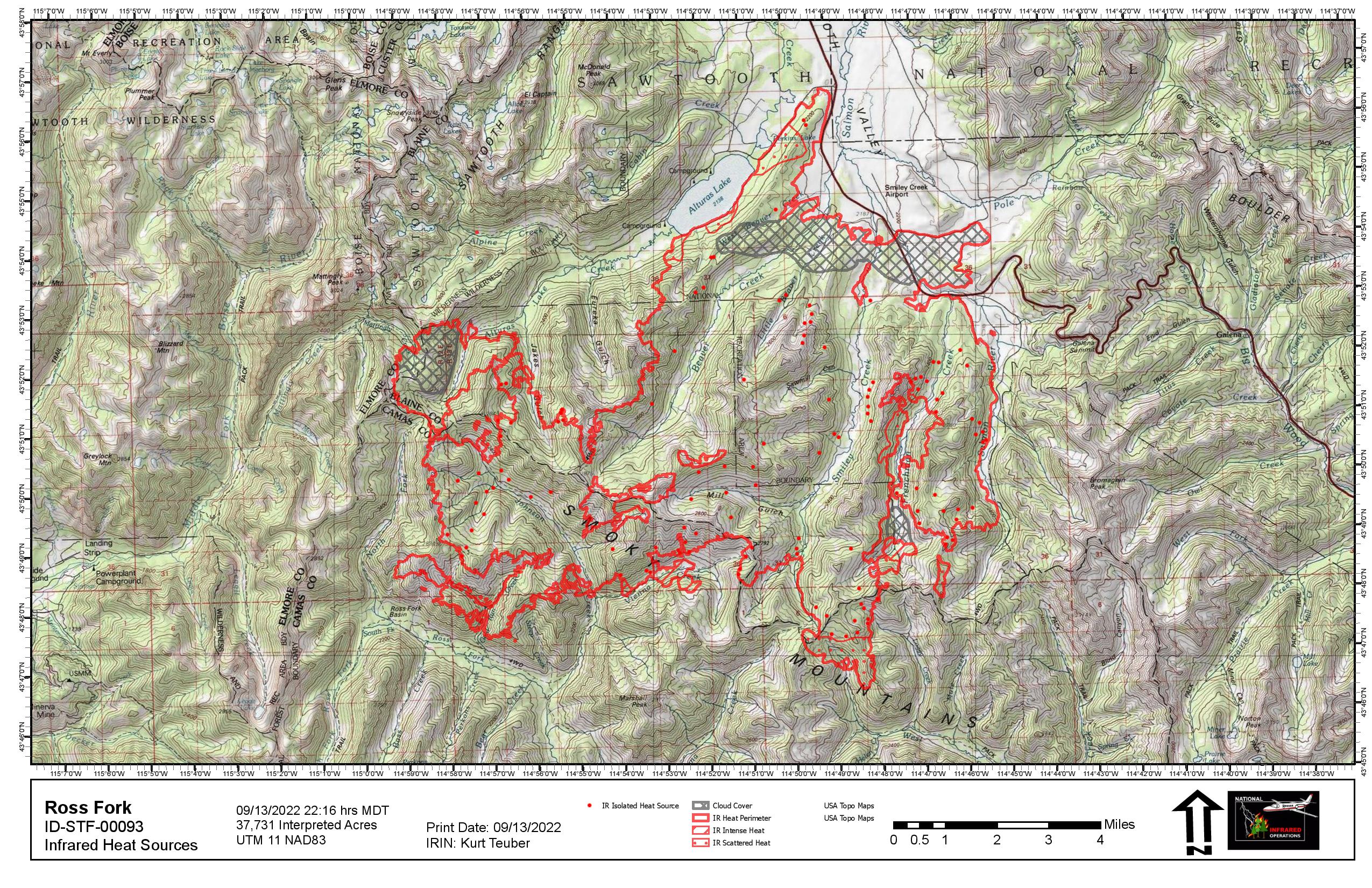
Ross Fork Fire Daily Update Tuesday September 13
Related Incident: Ross Fork
Publication Type: News
Ross Fork Fire Daily Update
September 13, 2022
Fire Information: Email: 2022.rossfork@firenet.gov Phone:208-329-6044 daily from 8 a.m. - 8 p.m.
Sawtooth National Forest Facebook: https://www.facebook.com/sawtoothnationalforest
YouTube:https://youtu.be/Ll7iJz55hnI
Inciweb: https://inciweb.nwcg.gov/incident/8375
Containment: 13%
Cause: Lightning
Acreage: 37,612 Acres
Location: Sawtooth National Forest, Idaho
Fuel Type: Timber Litter/Timber/Short Grass
A community meeting will be held in Fairfield on Wednesday, September 14 at 6 p.m., at the Camas County Senior Center, 129 Willow Ave. West. Fire personnel will give an update on fire activity and answer questions. The event will be recorded and shared on the fire’s YouTube channel and the Sawtooth NF Facebook page.
Light rain fell across parts of the fire area intermittently overnight and this morning. More moisture will be spreading across the region today with isolated showers and the potential brief, heavy rain. The weather will moderate fire behavior but firefighters will still be hard at work across the Ross Fork Fire, putting out hot spots, strengthening fire lines, assessing and preparing structures, and removing hazardous trees along roadways. The fire behavior analyst (FBAN) on the Ross Fork Fire says the moisture will, for now, prevent grasses and sagebrush from burning. Heavier fuels – large trees both alive and dead – will continue to burn until larger amounts of rain or snow fall.
Heavy helicopters were in the air Monday, dropping buckets of water to “check-up” the fire in areas where the fire was burning the hottest. Water drops decrease the fire’s intensity and slow its rate of spread. This tactic was used in the Vienna Creek drainage and Jake’s Gulch, southwest of Alturas Lake. Ground crews were at work on roads inside the fire perimeter, cutting hazardous trees along roadways so they will be safe for travel when the area is reopened.
The USDA Forest Service and Idaho Department of Lands initiated Stage 1 fire restrictions on the Sawtooth North Zone, effective Sunday, September 11. The order encompasses lands north of Highway 20 to the northern most Sawtooth National Forest boundary situated in Blaine, Camas, and portions of Custer, Elmore, and Boise counties, can be found at: https://www.fs.usda.gov/Internet/FSE_DOCUMENTS/fseprd1059189.pdf. Stage 1 fire restrictions apply to all state, state endowment, and private land in the North Zone that lie within the boundary of the Sawtooth National Forest.
TRAFFIC AND DRIVING CONDITIONS: Highway 75 has been open continuously for the past five days but still may be subject to intermittent safety closures. Current road information is at https://511.idaho.gov/.
CLOSURES AND RESTRICTIONS: Closure order 0414-05-059 has been issued by the Sawtooth National Forest for areas surrounding the #RossForkFire on the Sawtooth National Recreation Area AND Fairfield Ranger District. Visit https://www.fs.usda.gov/alerts/sawtooth/alerts-notices, for more information.
AIR QUALITY: Wildfire smoke can be hazardous to your health. For more information, please visit: https://www.airnow.gov
EVACUATIONS: The Pettit Lake Road, Cabin Creek Road, and Alturas Lake areas have been reduced to “SET” evacuation status, meaning anyone still in that area should be ready to leave immediately. Smiley Creek and Sawtooth City remain in “GO” evacuation status, which means evacuate now. Visit https://www.blainesheriff.com/152/Sheriff for more information. The Galena area remains in “SET” status. Public lands in all these areas remain closed.
TOTAL FIRE RESOURCES ASSIGNED
Personnel
712
Hand Crews
14
Engines
48
Helicopters
8
Visit our website at: www.fs.usda.gov/Sawtooth and on Facebook at: https://www.facebook.com/sawtoothnationalforest