
Kootenai River Complex Fact Sheet Sept 12 2022
Related Incident: Kootenai River Complex
Publication Type: News
Incident Command: Type 2 Northern Rockies Incident Management Team 4, Rick Connell, I.C.
Estimated Size: 19,708 acres
Completion/Containment: 0%
Personnel: 346
Current Status: The Russell Mountain and Trout Fires burned together and will now be called the Russell Mountain Fire. Fire activity on the Russell Mountain and Katka Fires continues to be a low intensity, backing ground fire that has been slowly moving downhill. Firefighters continued to improve fireline and remained in place during both the day and night shifts to hold and suppress the fire as it reaches the fireline and Westside Road. The Russell Mountain Fire has reached constructed fireline west of the Westside Road and the Westside Road in several locations between Trout Creek Road and Ball Creek Road. Crews have been successful holding the fire in these locations. Due to cloud cover, the overnight infrared detection flight was only able to map the north half of the Russell Mountain Fire showing an increase in size of 404 acres.
Planned Actions: Crews will work on handline construction south of the Ball Creek Road area to strengthen and connect with already completed fireline. The fire is expected to continue backing downhill towards the Westside Road and prepared fireline. Firefighters and engines continue to hold and suppress the fire as it reaches the constructed line and road along and near the Westside Road. Crews will begin thinning vegetation in some areas along the west side of the Westside Road. Weather conditions are expected to be smokey with the possibility of north/northeast winds increasing from mid to late in the day. On the Katka Fire, opportunities for fireline will be scouted and fire activity monitored throughout the day. Helicopters are available to be used for water delivery as needed however, wind and smoke conditions could prevent flying.
Weather: Cloud cover will spread across the region as a weather system passes to the north in Canada. Outflow winds from thunderstorms could potentially channel through the fire area by mid to late afternoon gusting 10 to 15 mph. Relative humidity levels will drop as low as 30% in the afternoon in the valley.
Closures: Due to active fires and fire suppression activities, the Westside Road is restricted to residents-only. Additionally, the following National Forest Trails are now closed: Ball Creek Road (FR 432), Trout Creek Road (FR 634), Russell Mountain (No. 12), Russell Ridge (No. 92), Ball and Pyramid Lakes (No. 43), Pyramid Pass (No. 13), Pyramid Peak (No. 7), Fisher Peak (No. 27), Trout Lake (No. 41), McGinty Ridge (No. 143), Clifty Mountain and Clifty/Burrow (No. 182), Myrtle Peak Trail (No. 286), and Burton Peak Trail (No. 9).
Evacuations: There are NO Evacuations currently in place. However, those living on the Westside Road closest to Ball Creek, Burton Creek, and Clark Creek have been placed in the SET fire evacuation status. SET is the stage of readiness before an actual evacuation takes place. If not voluntarily evacuating already, residents in this stage are advised to at least gather their evacuation supplies or pre-load them into their vehicles to enable a quick exit if evacuation is triggered. Residents of Boundary County, Idaho can visit https://www.nixle.com or text their home zip code to 888777 to sign up for emergency alerts. To learn more about READY SET GO, visit https://bit.ly/3wi0jMu .
Temporary Flight Restrictions (TFR): There is a TFR in place for air space over the Katka Fire (2-1234) and the Scotch Creek, Russell Mountain, Eneas Peak, and Trout Fires (2-1621) for aviation safety. Remember that temporary flight restrictions also apply to unmanned aircraft systems (UAS) or drones. If you fly, we can’t!
Kootenai River Complex Fact Sheet Sept 11 2022
Related Incident: Kootenai River Complex
Publication Type: News
Incident Command: Type 2 Northern Rockies Incident Management Team 4, Rick Connell, I.C.
Estimated Size: 19,304 acres
Completion/Containment: 0%
Personnel: 345
Current Status: Yesterday, the Russell Mountain Fire continued to slowly back down the mountain slope west of the Westside Road. The observed fire activity continued to be low intensity, with backing ground fire slowly moving downhill. The fire reached the constructed fireline and Westside Road in several locations between Trout Creek Road and Ball Creek Road. Fire Crews and Engines continue to be in place during the day and night shifts to hold and suppress the fire as it reaches the fireline and road. With light winds the fire activity on the Katka Fire was again observed to be low to moderate. The Eneas Peak and Trout Fires grew together and will now be called the Trout Fire. The overnight infrared detection flight mapped an increase of 17 acres on the Katka Fire and a combined Complex increase in size of 840 acres.
Planned Actions: Fireline construction will continue north of the Trout Creek Road with heavy equipment removing vegetation and crews setting up water hose systems. The fire is expected to slowly back downhill towards the road and fireline. Firefighters and engines will continue to hold and suppress the fire as it reaches the constructed lines and road along and near the Westside Road. Crews have been preparing roads and structure protection equipment as well as constructed fireline in anticipation of the fire moving downslope in these areas. Weather conditions are expected to be very smokey with light winds and additional smoke moving into the area from other fires to the west. Fire activity on the Katka Fire will continue to be monitored. Helicopters remain available to be used for water delivery as needed however, smoke conditions will likely prevent flying today.
Weather: Temperatures will be warm with highs near 80 degrees as high pressure remains in place over northern Idaho. Relative humidity levels will drop as low as 20-25% in the afternoon. Winds over the fire area will remain terrain driven going upslope at 5 mph during the day and then becoming downslope in the evening.
Closures: Due to active fires and fire suppression activities, the Westside Road is restricted to residents-only. Additionally, the following National Forest Trails are now closed: Ball Creek Road (FR 432), Trout Creek Road (FR 634), Russell Mountain (No. 12), Russell Ridge (No. 92), Ball and Pyramid Lakes (No. 43), Pyramid Pass (No. 13), Pyramid Peak (No. 7), Fisher Peak (No. 27), Trout Lake (No. 41), McGinty Ridge (No. 143), Clifty Mountain and Clifty/Burrow (No. 182), Myrtle Peak Trail (No. 286), and Burton Peak Trail (No. 9).
Evacuations: There are NO Evacuations currently in place. However, those living on the Westside Road closest to Ball Creek, Burton Creek, and Clark Creek have been placed in the SET fire evacuation status. SET is the stage of readiness before an actual evacuation takes place. If not voluntarily evacuating already, residents in this stage are advised to at least gather their evacuation supplies or pre-load them into their vehicles to enable a quick exit if evacuation is triggered. Residents of Boundary County, Idaho can visit https://www.nixle.com or text their home zip code to 888777 to sign up for emergency alerts. To learn more about READY SET GO, visit https://bit.ly/3wi0jMu .
Temporary Flight Restrictions (TFR): There is a TFR in place for air space over the Katka Fire (2-1234) and the Scotch Creek, Russell Mountain, Eneas Peak, and Trout Fires (2-1621) for aviation safety. Remember that temporary flight restrictions also apply to unmanned aircraft systems (UAS) or drones. If you fly, we can’t!
Inciweb: https://inciweb.nwcg.gov/incident/8378/
Email: 2022.kootenai@firenet.gov
Fire Information Phone: 208-202-5021
Boundary County Emergency Line: (208) 696-2626
Kootenai River Complex Factsheet Sept 10 2022
Related Incident: Kootenai River Complex
Publication Type: News
Incident Command: Type 2 Northern Rockies Incident Management Team 4, Rick Connell, I.C.
Estimated Size: 18,464 acres
Completion/Containment: 0%
Personnel: 332
Current Status: Yesterday and last night the Russell Mountain Fire slowly backed down the slopes west of the Westside Road generating quite a bit of smoke. Light white smoke is an indicator of a low intensity ground fire burning through light fuels. The observed fire activity was a low intensity, backing ground fire that slowly moved downhill and reached the fireline near Trout Creek Road and the Westside Road near Ball Creek Road in the evening. Fire Crews and Engines continue to be in place all day and night to hold the fire at these lines. The Fire activity on the Katka Fire was observed to be low to moderate. The Eneas Peak and Trout Fires grew together in the drainage between Fisher and Farnham Peaks. The overnight infrared detection flight mapped an increase of 26 acres on the Katka Fire and a combined Complex increase in size of 1,088 acres.
Planned Actions: Crews will continue to work on fireline construction west of the Eneas Peak Fire using heavy equipment to cut and remove vegetation and set up hoses for water delivery. The fire is expected to continue to slowly back downhill and reach the constructed firelines west of the Westside Road in several locations. Crews have spent a week preparing these firelines, the roads, and structure protection in anticipation of the fire moving downslope. The current conditions with light winds are ideal for holding and securing these lines. Firefighters will be working in these areas all day and a night shift will take over tonight. The Katka Fire will continue to be monitored. Helicopters remain available to be used for water delivery as needed and weather conditions allow.
Weather: Temperatures are forecasted to increase over the weekend and with lighter winds from the north and northwest tomorrow. Wind in the fire area will be terrain-driven, shifting from upslope during the day to downslope in the evening. Relative Humidity levels will range from 50-60% overnight and drier in afternoon.
Closures: Due to active fires and fire suppression activities, the Westside Road is restricted to residents-only. Additionally, the following National Forest Trails are now closed: Ball Creek Road (FR 432), Trout Creek Road (FR 634), Russell Mountain (No. 12), Russell Ridge (No. 92), Ball and Pyramid Lakes (No. 43), Pyramid Pass (No. 13), Pyramid Peak (No. 7), Fisher Peak (No. 27), Trout Lake (No. 41), McGinty Ridge (No. 143), Clifty Mountain and Clifty/Burrow (No. 182), Myrtle Peak Trail (No. 286), and Burton Peak Trail (No. 9).
Evacuations: There are NO Evacuations currently in place. However, those living on the Westside Road closest to Ball Creek, Burton Creek, and Clark Creek have been placed in the SET fire evacuation status. SET is the stage of readiness before an actual evacuation takes place. If not voluntarily evacuating already, residents in this stage are advised to at least gather their evacuation supplies or pre-load them into their vehicles to enable a quick exit if evacuation is triggered. Residents of Boundary County, Idaho can visit https://www.nixle.com or text their home zip code to 888777 to sign up for emergency alerts. To learn more about READY SET GO, visit https://bit.ly/3wi0jMu .
Temporary Flight Restrictions (TFR): There is a TFR in place for air space over the Katka Fire (2-1234) and the Scotch Creek, Russell Mountain, Eneas Peak, and Trout Fires (2-1621) for aviation safety. Remember that temporary flight restrictions also apply to unmanned aircraft systems (UAS) or drones. If you fly, we can’t!
Inciweb: https://inciweb.nwcg.gov/incident/8378/
Email: 2022.kootenai@firenet.gov
Fire Information Phone: 208-202-5021
Boundary County Emergency Line: (208) 696-2626
Kootenai River Complex Fact Sheet Sept 9 2022
Related Incident: Kootenai River Complex
Publication Type: News
Incident Command: Type 2 Northern Rockies Incident Management Team 4, Rick Connell, I.C.
Estimated Size: 17,376 acres
Completion/Containment: 0%
Personnel: 279
Current Status: Yesterday, fire activity on the Eneas Peak, Trout, Russell Mountain, and Scotch Creek Fires moderated with fire backing down slopes and burning heavy dead and down trees in the higher and mid-elevations, producing noticeable smoke. Due to the steep terrain, fire can spread when burning material rolls downslope and then fire moves back upslope. While fire is not threatening the historic Burton Peak Lookout, as a precautionary measure and due to the remote location, a crew wrapped the Lookout which is commonly done on historic structures. The Scotch Creek and Russell Mountain fires burned together on Wednesday north of Ball Creek and are now called Russell Mountain. The Katka Fire was active on its northwest side so two helicopters were used to drop buckets of water and reduce pockets of heat. The overnight infrared detection flight mapped an increase of 60 acres on the Katka Fire and a combined Complex increase in size of 1,736 acres.
Planned Actions: Crews will strengthen the firelines located along the Westside Road, working on clearing and removing vegetation and setting up hose lines for water delivery. The set-up of structure protection equipment along the Westside Road has been completed but all pumps, hose, and sprinklers will be checked and tested again today. The east side of the Russell Mountain Fire is slowly moving downslope towards the constructed fireline and firefighters will be ready to hold that line as the fire approaches. The Katka Fire is expected to continue its movement through heavy dead and downed trees in steep terrain. Northeast winds could push the fire slightly south today. Helicopters continue to be available for water delivery as needed on both the Katka Fire and the Eneas Peak, Trout, and Russell Mountain Fires as wind and smoke conditions allow.
Weather: Light, north winds are forecasted for tomorrow. Relative Humidity levels will range from 20-30% and temperatures will be cooler. Steep terrain will continue to shelter areas of heat from the winds.
Closures: Due to active fires and fire suppression activities, the Westside Road is restricted to residents-only. Additionally, the following National Forest Trails are now closed: Ball Creek Road (FR 432), Trout Creek Road (FR 634), Russell Mountain (No. 12), Russell Ridge (No. 92), Ball and Pyramid Lakes (No. 43), Pyramid Pass (No. 13), Pyramid Peak (No. 7), Fisher Peak (No. 27), Trout Lake (No. 41), McGinty Ridge (No. 143), Clifty Mountain and Clifty/Burrow (No. 182), Myrtle Peak Trail (No. 286), and Burton Peak Trail (No. 9).
Evacuations: There are NO Evacuations currently in place. However, those living on the Westside Road closest to Ball Creek, Burton Creek, and Clark Creek have been placed in the SET fire evacuation status. SET is the stage of readiness before an actual evacuation takes place. If not voluntarily evacuating already, residents in this stage are advised to at least gather their evacuation supplies or pre-load them into their vehicles to enable a quick exit if evacuation is triggered. Residents of Boundary County, Idaho can visit https://www.nixle.com or text their home zip code to 888777 to sign up for emergency alerts. To learn more about READY SET GO, visit https://bit.ly/3wi0jMu .
Temporary Flight Restrictions (TFR): There is a TFR in place for air space over the Katka Fire (2-1234) and the Scotch Creek, Russell Mountain, Eneas Peak, and Trout Fires (2-1621) for aviation safety. Remember that temporary flight restrictions also apply to unmanned aircraft systems (UAS) or drones. If you fly, we can’t!
Inciweb: https://inciweb.nwcg.gov/incident/8378/
Email: 2022.kootenai@firenet.gov
Fire Information Phone: 208-202-5021
Boundary County Emergency Line: (208) 696-2626
Kootenai River Complex Factsheet Sept 8 2022
Related Incident: Kootenai River Complex
Publication Type: News
Incident Command: Type 2 Northern Rockies Incident Management Team 4, Rick Connell, I.C.
Estimated Size: 15,640 acres
Containment: 0%
Personnel: 261
Current Status: The Katka Fire burned actively yesterday and last night as the fire consumed heavy dead and downed trees in steep terrain. The Katka Fire is not directly threatening private property and firefighters are scouting areas around the fire for roads and locations to potentially construct indirect firelines. The eastern sides of the Scotch Creek, Russell Mountain, and Trout Fires grew slightly yesterday, producing visible columns of smoke but the eastern sides of the fires were sheltered from the prevailing winds. Structure protection and water delivery systems east of the Eneas Peak Fire are in place and being tested and improved. Heavy equipment crews are completing the fireline west of the Westside Road and connected handline around Fisher and Trout Creek areas. Crews are removing vegetation and installing hose lines to improve constructed fireline and roads east of the Scotch Creek, Russel Mountain, Trout and Eneas Fires. The overnight infrared detection flight mapped an increase of 76 acres on the Katka Fire and a combined Complex increase in size of 1,950 acres.
Planned Actions: Engine crews will test and improve pump kits, hose, and sprinklers for structure protection along the Westside Road. Two helicopters are assigned to the Complex and two additional helicopters are on loan to the Complex. Helicopters will deliver buckets of water on the fires when wind and smoke conditions allow. Firefighters are contacting private landowners near the Katka Fire and developing a strategy that enables firefighters to safely engage the fire through indirect fireline locations. A night shift of three engine crews continue to patrol roads near the fire area and monitor fire activity and structure protection equipment.
Weather: Winds are gradually rotating to become more northerly with lighter speeds. Temperatures will be slightly cooler due to the passage of yesterday’s dry cold front. Relative Humidity levels improved overnight at higher elevations but remains moderate. There is no precipitation in the forecast. Closures: Due to active fires and fire suppression activities, the Westside Road is restricted to residents-only. Additionally, the following National Forest Trails are now closed: Ball Creek Road (FR 432), Trout Creek Road (FR 634), Russell Mountain (No. 12), Russell Ridge (No. 92), Ball and Pyramid Lakes (No. 43), Pyramid Pass (No. 13), Pyramid Peak (No. 7), Fisher Peak (No. 27), Trout Lake (No. 41), McGinty Ridge (No. 143), Clifty Mountain and Clifty/Burrow (No. 182), Myrtle Peak Trail (No. 286), and Burton Peak Trail (No. 9).
Evacuations: There are NO Evacuations currently in place. However, those living on the Westside Road closest to Ball Creek, Burton Creek, and Clark Creek have been placed in the SET fire evacuation status. SET is the stage of readiness before an actual evacuation takes place. If not voluntarily evacuating already, residents in this stage are advised to at least gather their evacuation supplies or pre-load them into their vehicles to enable a quick exit if evacuation is triggered. Residents of Boundary County, Idaho can visit https://www.nixle.com or text their home zip code to 888777 to sign up for emergency alerts. To learn more about READY SET GO, visit https://bit.ly/3wi0jMu .
Temporary Flight Restrictions (TFR): There is a TFR in place for air space over the Katka Fire (2-1234) and the Scotch Creek, Russell Mountain, Eneas Peak, and Trout Fires (2-1621) for aviation safety. Remember that temporary flight restrictions also apply to unmanned aircraft systems (UAS) or drones. If you fly, we can’t!
Inciweb: https://inciweb.nwcg.gov/incident/8378/
Email: 2022.kootenai@firenet.gov
Fire Information Phone: 208-202-5021
Boundary County Emergency Line: (208) 696-2626
Kootenai River Complex Fact Sheet Sept 7 2022
Related Incident: Kootenai River Complex
Publication Type: News
Incident Command: Type 2 Northern Rockies Incident Management Team 4, Rick Connell, I.C.
Estimated Size: 13,704 acres
Containment: 0%
Personnel: 207
Current Status: Heavy equipment crews worked to construct fireline west of the Westside Road, through some areas of slash from previous harvests. Crews worked in tandem with an excavator to reduce vegetation along roads and dozer lines and started to set up hose lines along some sections. Engine crews completed setting up pumps, hose, and sprinklers and testing the structure protection equipment along the Westside Road east of the Trout, Russell Mountain, and Scotch Creek Fires. Fire activity was calm yesterday with the most active fire north of Scotch Creek and south of the Russell Mountain Fires. Fire activity on the Katka Fire was creeping and slow, concentrated in areas of the large down trees on the north side. The overnight infrared detection flight mapped an increase in size of 1,217 acres on the Complex.
Planned Actions: Engine crews will set up pump kits, hose, and sprinklers for structure protection east of the Eneas Peak Fire and test the water delivery systems already set up at structures along the Westside Road. Heavy equipment crews will continue working on constructing fireline utilizing old roads west of the Westside Road. A night shift of three engine crews will patrol roads near the fire area and monitor fire activity and structure protection equipment. Helicopters will deliver buckets of water along the east side on the fires if wind and smoke conditions allow. Firefighters will scout for indirect fireline locations on the Katka Fire as a part of the process of developing a strategy that provides for firefighters to safely engage at the appropriate time.
Weather: A Red Flag Warning is in effect from 8am to 10pm on Wednesday. Temperatures will range from 74 to 90 degrees F and Relative Humidity levels as low as 18 to 28 percent. Winds will be out of the southwest at 6 to 17 mph with gusts up to 35 mph in the afternoon.
Closures: Due to active fires and fire suppression activities, the Westside Road is restricted to residents-only. Additionally, the following National Forest Trails are now closed: Ball Creek Road (FR 432), Trout Creek Road(FR 634), Russell Mountain (No. 12), Russell Ridge (No. 92), Ball and Pyramid Lakes (No. 43), Pyramid Pass(No. 13), Pyramid Peak (No. 7), Fisher Peak (No. 27), Trout Lake (No. 41), McGinty Ridge (No. 143), Clifty Mountain and Clifty/Burrow (No. 182), Myrtle Peak Trail (No. 286), and Burton Peak Trail (No. 9).
Evacuations: There are NO Evacuations currently in place. However, those living on the Westside Road closest to Ball Creek, Burton Creek, and Clark Creek have been placed in the SET fire evacuation status. SET is the stage of readiness before an actual evacuation takes place. If not voluntarily evacuating already, residents in this stage are advised to at least gather their evacuation supplies or pre-load them into their vehicles to enable a quick exit if evacuation is triggered. Residents of Boundary County, Idaho can visit https://www.nixle.com or text their home zip code to 888777 to sign up for emergency alerts. To learn more about READY SET GO, visit https://bit.ly/3wi0jMu .
Temporary Flight Restrictions (TFR): There is a TFR in place for air space over the Katka Fire (2-1234) and the Scotch Creek, Russell Mountain, Eneas Peak, and Trout Fires (2-1621) for aviation safety. Remember that temporary flight restrictions also apply to unmanned aircraft systems (UAS) or drones. If you fly, we can’t!
Inciweb: https://inciweb.nwcg.gov/incident/8378/
Email: 2022.kootenai@firenet.gov
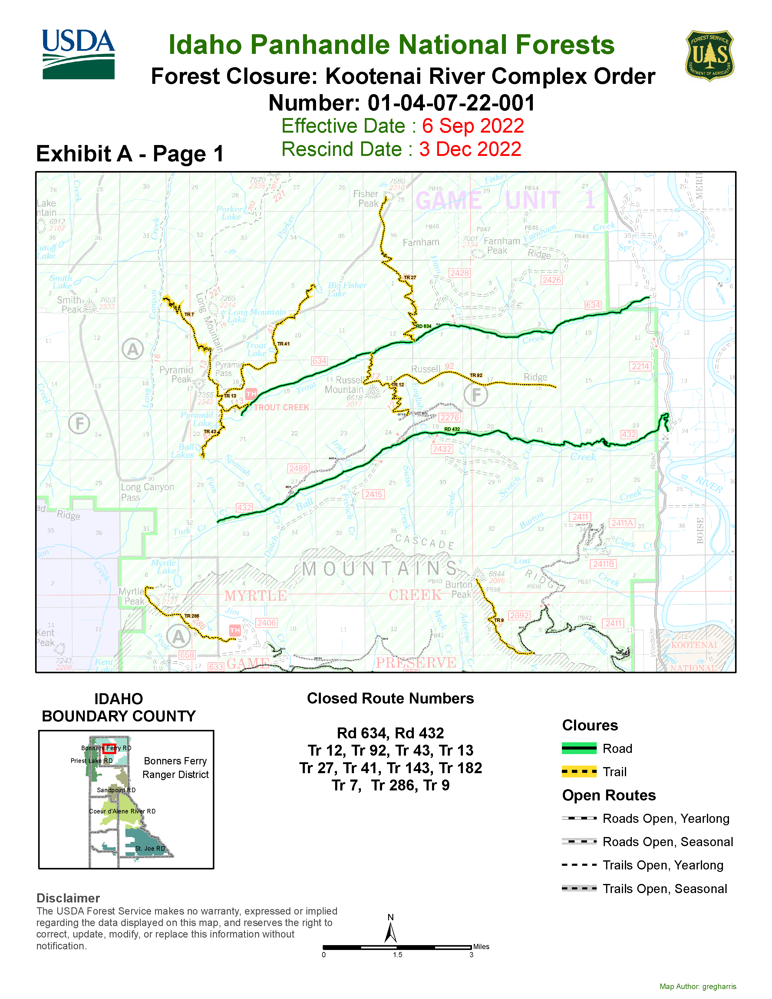
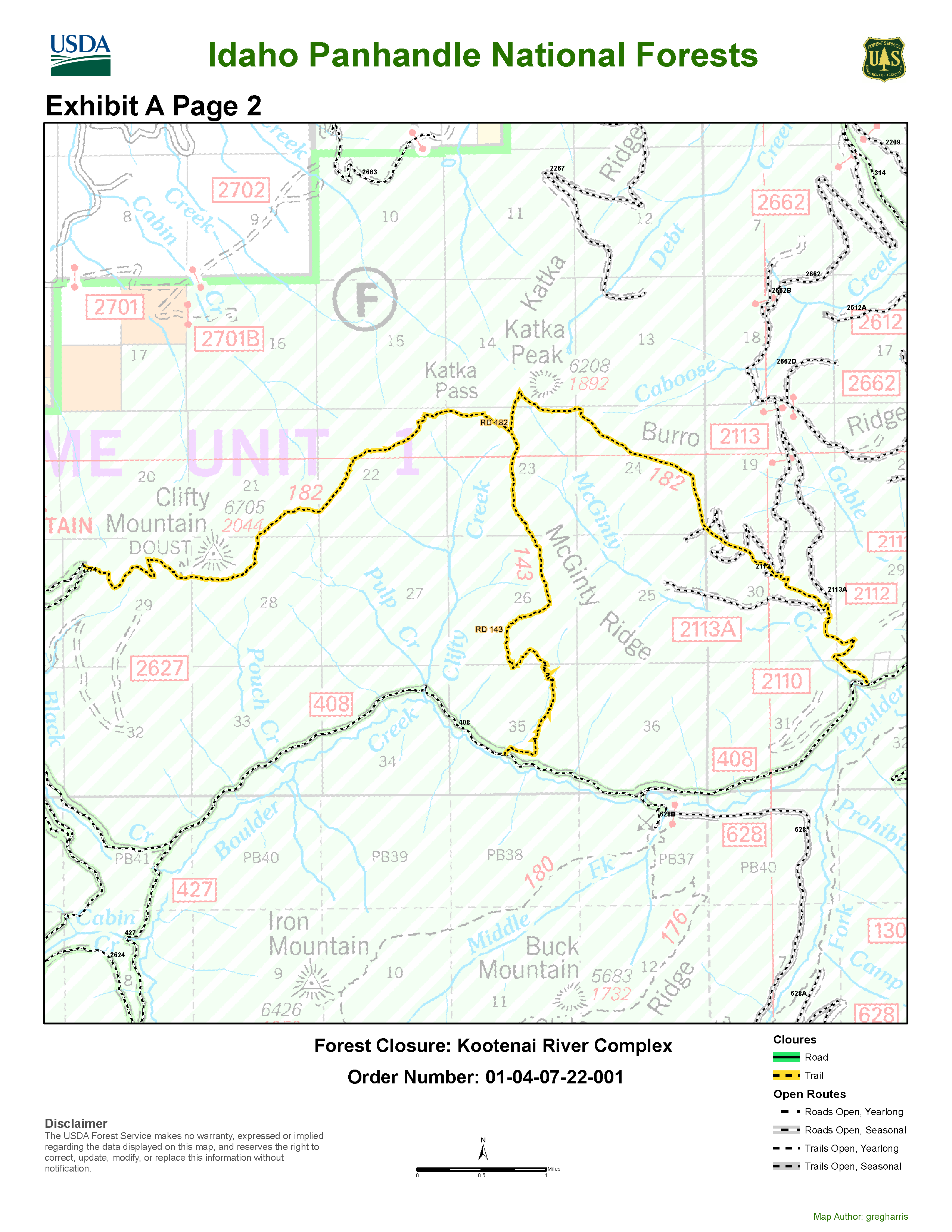
Kootenai River Complex Road and Trail Closure
Related Incident: Kootenai River Complex
Publication Type: Closures
Order Number: # 01-04-07-22-001
U.S. Department of Agriculture, U.S. Forest Service
Idaho Panhandle National ForestBonners Ferry Ranger District
Kootenai River Complex Road and Trail Closure
PROHIBITIONS
Pursuant to 16 U.S.C. § 551 and 36 C.F.R. § 261.50 (b), the following are prohibited onthe Bonners Ferry Ranger District of the Idaho Panhandle National Forests, describedbelow and shown on the attached map incorporated into this Order as Exhibit A (the“Described Roads and Trails”):1. Being on the Road [36 CFR § 261.54(e)]2. Being on the Trail [36 CFR § 261.55(a)]
EXEMPTIONS
Pursuant to 36 C.F.R. § 261.50(e), the following persons are exempt from this Order:1. Persons with a special use authorization or other Forest Service authorizationspecifically exempting them from the effect of this order. 36 CFR § 261.50 (e)(1)2. Any Federal, State, or Local Officer, or member of an organized rescue orfirefighting resource in the performance of an official duty. 36 CFR § 261.50 (e)(4).
DESCRIBED ROADS/TRAILS
The entirety of the Ball Creek Road (FSR 432) and the Trout Creek Road (FSR 634).Also, the Russell Mountain Trail (No. 12), Russell Ridge Trail (No. 92), Ball & PyramidLakes Trail (No. 43), Pyramid Pass Trail (No. 13), Pyramid Peak Trail (No. 7), Fisher PeakTrail (No. 27), Myrtle Peak Trail (No. 286), Burton Peak Trail (No. 9), Trout Lake Trail (No.41), McGinty Ridge Trail (No. 143) and Clifty Trail (No. 182).
PURPOSE
The purpose of this Closure Order is for public safety due to wildfire effects and activitieson the Kootenai River Complex, on the Bonners Ferry Ranger District. The closureprohibits all methods of travel (foot, mechanized, motorized, and stock) on the closedroads and closed trails (see map).
IMPLEMENTATION
1. This Order shall be in effect from September 6, 2022, through December 3, 2022,unless rescinded.
2. A map identifying the Described Roads/Trails is attached and made part of this Order as Exhibit A. For a digital version of this Order and Exhibit A, go tohttps://www.fs.usda.gov/alerts/ /alerts-notices.
3. Unless otherwise expressly defined in this Order, the terms used in this Order are defined by the regulations of the Secretary of Agriculture, 36 C.F.R. Chapter II, Parts 200-299. If there are terms in this Order that are not expressly defined in the Order or 36 C.F.R. Chapter II, Parts 200-299, their meaning shall be determined by their plain language definitions.
4. A violation of the above prohibitions is punishable as a Class B misdemeanor by a fine of not more than $5,000 for individuals and $10,000 for organizations, or by imprisonment for not more than six months, or both. 16 U.S.C. § 551; 18 U.S.C.§§ 3559, 3571, and 3581.5.
Contact the Bonners Ferry Ranger District in Bonners Ferry Idaho at (208) 267-5561, and the Idaho Panhandle National Forests Supervisor’s Office in Coeur d’Alene Idaho (2080 765-7723), for more information about this Order.6. This Order supersedes any previous Orders prohibiting the same or similar acts on the same Described Road/Trail.
Signed and issued on September 6, 2022.
Westside Road Restricted to Residents Only
Related Incident: Kootenai River Complex
Publication Type: Closures
No Evacuations in Place – Westside Road Restricted to Residents OnlyThere are currently no evacuations in place in Boundary County in response to the Kootenai River Complex fires, however, as a precaution the following “Ready, Set, GO!” pre-evacuation preparations are in place:
• “Set” - Westside Road from the Kootenai Wildlife Refuge north to Farnham Creek, have been advised to be in the “Set” stage of evacuation preparation, to evacuate immediately if it becomes necessary. (Scotch and Russell Mountain Fires)
• “Ready” - Westside Road north of Farnham Creek to Kerr Lake Road have been advised to be in the “Ready” stage of evacuation to begin evacuation planning for their families, pets, and livestock. (Eneas Peak Fire)
• “Ready” – Katka Road up from the lookout area, Two-Tail Road, and Misty Mountain Road have been advised to be in the “Ready” stage of evacuation to begin evacuation planning for their families, pets, and livestock. (Katka Fire)
In addition, access to Westside Road traffic is being limited to residents of Westside Road for public and firefighter safety. Non-resident traffic will interfere with the numerous structure protection and firefighting activities occurring along the road and could hinder any evacuation operations, should they occur.
The two best things residents can do to receive official notifications quickly are to sign up for Nixle text alerts by texting 83805 to 888777, and to continue to monitor local information sources.
Current evacuation status information is also available in a recorded message on the Boundary County Emergency Information Line at 208-696-BOCO (2626).
Updates to evacuation preparedness stages will also be posted on the Boundary County Emergency Management/PIO Facebook page.To obtain an electronic copy of the Boundary County Ready, Set, Go! Evacuation planning brochure, visit boundarycountyid.org.
Kootenai River Complex Factsheet Sept 6 2022
Related Incident: Kootenai River Complex
Publication Type: News
Containment: 0%
Personnel: 168
Current Status: Crews conducted structure assessments and installed structure protection equipment on private properties located along the Westside Road. Bucket water drops were conducted to slow fire spread along the eastern sides of the Scotch and Russell Mountain Fires. Heavy equipment was used to start preparing old forest roads located to the west of the Westside Road as firelines. On the Katka Fire crews scouted the fire area on the ground and by helicopter to assess the high risks to firefighter safety. Due to steep terrain, dead or fire weakened trees that could fall at any time, and a long hike into the fire area it was determined that an indirect fire suppression strategy needs to be developed. The overnight infrared detection flight mapped an increase in size of 1,707 acres on the Complex.
Inciweb: https://inciweb.nwcg.gov/incident/8378/
Email: 2022.kootenai@firenet.gov
Kootenai River Complex Fact Sheet Sept 5 2022
Related Incident: Kootenai River Complex
Publication Type: News
Incident Command: Type 2 Northern Rockies Incident Management Team 4, Rick Connell, I.C.
Estimated Size: 10,780 acres
Containment: 0%
Personnel: 204
Current Status: Yesterday, helicopters were utilized to make bucket drops and slow fire spread along the eastern sides of the Scotch and Russell Mountain Fires. In addition, crews conducted structure assessments and reinforced structure protection equipment on private properties located along the Westside Road. Work started on preparing some old forest roads located to the west of the Westside Road in an effort to prepare a check line or location to slow up fire spread. On the Katka Fire crews continued work on direct perimeter control lines to hold and suppress the fire. The overnight infrared detection flight mapped an increase in size of 1,357 acres on the Complex, with most growth occurring on the Russell Mountain and Trout Fires.
Planned Actions: Helicopter bucket water drops will be conducted on the Scotch Creek, Russell Mountain, Eneas Peak, and Trout Fires if wind and smoke conditions allow for safe flying. Structure protection assessments and preparations on private properties located along the Westside Road will continue. Crews will also continue working on preparing a check line utilizing old roads west of the Westside Road. It is expected to take 2-3 days to get this line preparation work done. A night shift continues to work overnight monitoring structure protection equipment and fire activity. On the Katka Fire a Hotshot crew has joined the Type 2 Crew and together they will work on constructing direct perimeter control line.
Closures: Due to active fires and fire suppression activities, visitors are advised to avoid Ball Creek Road (FR 432), Trout Creek Road (FR 634) and trails. Additional trails to avoid include Russell Mountain (No. 12), Russell Ridge (No. 92), Ball and Pyramid Lakes (No. 43), Pyramid Pass Trail (No. 13), Pyramid Peak (No. 7), Fisher Peak (No. 27), Trout Lake (No. 41), McGinty Ridge Trail (No. 143), Clifty Mountain and Clifty/Burrow Trail (No. 182).
Evacuations: There are NO Evacuations currently in place. However, those living on the Westside Road closest to Ball Creek, Burton Creek, and Clark Creek have been placed in the SET fire evacuation status. SET is the stage of readiness before an actual evacuation takes place. If not voluntarily evacuating already, residents in this stage are advised to at least gather their evacuation supplies or pre-load them into their vehicles to enable a quick exit if evacuation is triggered. When living in fire-prone areas, all residents must have an evacuation plan, including all essential documents, pictures, prescriptions, and pets, and be quickly transportable. Residents of
Boundary County, ID can visit https://www.nixle.com or text their home zip code to 888777 to sign up for emergency alerts. To learn more about READY SET GO, visit https://bit.ly/3wi0jMu . For more tips on defensible space for homes, visit Firewise at https://bit.ly/3PALyeG .
Temporary Flight Restrictions (TFR): There is a TFR in place for air space over the Katka Fire (2-1234) and the Scotch Creek, Russell Mountain, Eneas Peak, and Trout Fires (2-1621) to lessen impacts to local aviation operators. Remember that temporary flight restrictions also apply to unmanned aircraft systems (UAS) or drones. If you fly, we can’t!
Inciweb: https://inciweb.nwcg.gov/incident/8378/
Email: 2022.kootenai@firenet.gov
Facebook: https://facebook.com/USFSIPNF
Boundary County Emergency Line: (208) 696-2626
Fire Information Phone: 208-557-8813