
Updated Fire Evacuation for Double Creek and Eagle Cap Fires 09062022
Related Incident: Goat Mountain 2 Fire
Publication Type: Announcement
Updated notice from Wallowa County Office of Sheriff, Joel Fish
Fire Evacuation - Tuesday, September 6, 2022
Double Creek and Eagle Cap Wilderness Fires
New Evacuations in BOLD
Level 1 – Be Ready to Leave
Lostine River Rd from Hwy 82 to Fir Rd
Upper Imnaha from Pallette Ranch to FS 39 Rd
Level 2 – Get Set to Leave
Lostine River Rd from Fir Rd south to Two Pan including all campgrounds and trailheads
Upper Imnaha from Grouse Creek to Pallete Ranch
Areas around Dug Bar Rd north of Fence Creek
Level 3 – Go – Evacuate the Area
Town of Imnaha north to Fence Creek including lands east to Lightning Creek & south to Grouse Creek
Road Closures
Lostine River Rd from Moffitt’s south Closed
Lower Imnaha Rd & Dug Bar Rd Closed
Upper Imnaha Rd closed
Hat Point Rd closed
FS 39 Rd is closed from Target Springs Junction to Ollokot Campground including the Canal Rd (3920), and Lick Creek Rd (3925)
Double Creek Eagle Cap Wilderness Fires Update 09062022
Related Incident: Goat Mountain 2 Fire
Publication Type: News
Double Creek and Eagle Cap Wilderness Fires
September 6, 2022
Daily Update – 8:00 AM
Highlights: There was an increase in fire activity on the southern end of the Double Creek Fire on Monday afternoon. Fire activity remained relatively light on the Nebo, Sturgill, and Goat Mountain 2 Fires. In anticipation of extreme fire weather, Oregon Governor Kate Brown night invoked the Conflagration Act for the Sturgill Fire on Monday. The Office of the State Fire Marshal (OSFM) ordered five additional task forces to support the fire.
Eagle Cap Wilderness Fires: There are four lightning caused fires within the Eagle Cap Wilderness. The previously reported Goat Mountain 1 Fire has merged with the Goat Mountain 2 Fire and will be reported as the Goat Mountain 2 Fire. The Nebo, Sturgill, and Goat Mountain 2 Fires are active and being managed to protect public and private infrastructure, while playing a natural role within designated Wilderness.
Goat Mountain 2 Fire: 152 acres | 0% contained | 2 personnel assigned
Fire activity was minimal on the Goat Mountain 2 Fire Monday. Lookouts will continue to monitor the fire, and firefighters will take action to suppress the fire in Lostine Canyon if needed.
Weather: The Fire Weather Watch has been elevated to a Red Flag Warning this evening from 6:00 p.m. through Wednesday at 8:00 p.m. Temperatures will be in the mid to upper-90s, maximum relative humidity values of 20 percent, and southwest winds at 10-15 mph on Tuesday. Critical fire weather conditions are expected Tuesday night through Wednesday evening with continued hot, dry, breezy conditions. There will be a slight chance for showers and thunderstorms Wednesday afternoon and evening; however, these will produce little rain along with erratic, gusty winds up to 45 mph.
Smoke: Current air quality information for the local area is available on the Oregon Department of Environmental Quality - Air Quality Monitoring website and PurpleAir website.
Evacuations: Level 1, Level 2, and Level 3 evacuations have been issued by the Wallowa County Sheriff's Office. A Level 3 “Go Now” is in effect for the Town of Imnaha and south to Freezeout Road. A Level 2 “Get Set” is in effect for the area from the Town of Imnaha north to Fence Creek including the lands east toward Lightning Creek, and Lostine River Road from Fir Road south including all campgrounds. A Level 1 “Be Ready” is in effect from Freezeout south to the Pallette Ranch and Imnaha River Woods, and Lostine River Road from Highway 82 to Fir Road.
Closures: The Wallowa Whitman National Forest issued Temporary Area Closures for the Double Creek Fire, Nebo Fire, and Sturgill Fire (includes Goat Mountain 2 Fire) on Monday. Closure Orders and Maps are available on the Wallowa Whitman National Forest Fire Incident Updates page. The Wallowa County Sheriff's Office has closed several roads associated with evacuation orders. The Upper Imnaha Road, Hat Point Road, and Wallowa Mountain Loop Road (Forest Service Road 39) are closed. Wallowa Mountain Loop Road (FSR 39) is closed from Target Springs Junction to Ollokot Campground including the Canal Road (FSR 3920), and Lick Creek Rd (FSR 3925).
Airspace: Several airspace restrictions have been issued for the Double Creek, Nebo, Sturgill, and Goat Mountain 2 Fires. Temporary Flight Restriction (TFR) 2/1532 is in place to provide a safe environment for firefighting aircraft operations on the Double Creek Fire. Notice to Air Missions (NOTAM) 08/234 and NOTAM 08/235 were issued to provide safe airspace for the Nebo, Sturgill, and Goat Mountain 2 Fires. Flight restrictions also apply to drones. Drones flying in areas of wildfire activity will cause firefighting aircraft to be grounded.
Restrictions: Forest Order #06-16-00-22-04 covers Phase B Fire Restrictions for all National Forest System Lands within the Wallowa-Whitman National Forest, except for the area within a ¼ mile of the Snake River between Hells Canyon Dam, River Mile 247.5, downstream to the Oregon-Washington border at Snake River Mile 176.0, which is regulated by Forest Order #06-16-04-22-01.
Fire Information
Office Hours: 8:00 AM – 8:00 PM
Phone: 541-216-4579
Email: 2022.doublecreek@firenet.gov
Eagle Cap Wilderness Fires
Sturgill Fire InciWeb: https://inciweb.nwcg.gov/incident/8364/
Goat Mountain 2 Fire InciWeb: https://inciweb.nwcg.gov/incident/8380/
Facebook: www.facebook.com/eaglecapwildernessfires2022
YouTube: https://tinyurl.com/Eagle-Cap-Wilderness-Fires
FS 39 Road Closure Update 09052022
Related Incident: Goat Mountain 2 Fire
Publication Type: Closures
Forest Service 39 Road Closure Update - 09/05/2922:
FS 39 Rd is closed from Target Springs Junction to Ollokot Campground including the Canal Rd (3920), and Lick Creek Rd (3925).
These are recommendations as of 11:00 am on September 5, 2022.
Double Creek and Eagle Cap Wilderness Fires Update 09052022
Related Incident: Goat Mountain 2 Fire
Publication Type: News
Double Creek and Eagle Cap Wilderness Fires
September 5, 2022
Daily Update – 8:00 AM
Highlights: Fire activity was significantly less on Sunday for both the Double Creek and Eagle Cap Wilderness Fires. Although temperatures were warm and relative humidity values were low, winds were much lighter than the previous day. Additional resources continue to arrive, including task forces form the Oregon Office of the State Fire Marshal (OSFM).
Eagle Cap Wilderness Fires: There are four lightning caused fires within the Eagle Cap Wilderness. The Goat Mountain 1 Fire is currently not active. The Nebo, Sturgill, and Goat Mountain 2 Fires are active and being managed to protect public and private infrastructure, while playing a natural role within designated Wilderness.
Goat Mountain 2 Fire: 118 acres | 0% contained | 2 personnel assigned
There was no significant growth on the Goat Mountain 2 Fire on Sunday. Lookouts will continue to monitor the fire, and firefighters will take action to suppress the fire in Lostine Canyon if needed.
Weather: A weak cold front will move through the area in the early morning hours. Below normal fire weather conditions are expected Monday with moderate temperatures, higher relative humidity values, and light northwest winds behind the morning’s cold frontal passage. Tuesday and Wednesday’s weather is expected to result to above normal fire activity with increased winds from the southwest and temperatures in the 90s.
Smoke: Current air quality information for the local area is available on the PurpleAir website.
Evacuations: On Sunday, the Wallowa County Sheriff’s Office modified the evacuation levels for the Double Creek Fire. A Level 3 “Go Now” is in effect for the Town of Imnaha and south to Freezeout Road. The Upper Imnaha Road, Hat Point Road, and Wallowa Mountain Loop Road (Forest Service Road 39) are closed. A Level 2 “Get Set” is in effect for the area from the Town of Imnaha north to Fence Creek including the lands east toward Lightning Creek. A Level 1 “Be Ready” is in effect from Freezeout south to the Pallette Ranch and Imnaha River Woods. There are currently no evacuations for the Eagle Cap Wilderness Fires.
Closures: There are currently trail and road closures in effect for the Double Creek Fire as well as the Eagle Cap Wilderness Fires. Closure Orders and Maps are available on the Wallowa Whitman National Forest Fire Incident Updates page.
Airspace: Several airspace restrictions have been issued for the Double Creek and Eagle Cap Wilderness Fires. Temporary Flight Restriction (TFR) 2/1532 is in place to provide a safe environment for firefighting aircraft operations on the Double Creek Fire. Notice to Air Missions (NOTAM) 08/234 and NOTAM 08/235 were issued to provide safe airspace for the Eagle Cap Wilderness Fires. Flight restrictions also apply to drones. Drones flying in areas of wildfire activity will cause tactical firefighting aircraft to be grounded.
Restrictions: Forest Order #06-16-00-22-04 covers Phase B Fire Restrictions for all National Forest System Lands within the Wallowa-Whitman National Forest, except for the area within a ¼ mile of the Snake River between Hells Canyon Dam, River Mile 247.5, downstream to the Oregon-Washington border at Snake River Mile 176.0, which is regulated by Forest Order #06-16-04-22-01.
Fire Information
Office Hours: 8:00 AM – 8:00 PM
Phone: 541-216-4579
Email: 2022.doublecreek@firenet.gov
Eagle Cap Wilderness Fires
Sturgill Fire InciWeb: https://inciweb.nwcg.gov/incident/8364/
Goat Mountain 2 Fire InciWeb: https://inciweb.nwcg.gov/incident/8380/
Facebook: www.facebook.com/eaglecapwildernessfires2022
YouTube: https://tinyurl.com/Eagle-Cap-Wilderness-Fires
Double Creek and Eagle Cap Wilderness Fires Update 09042022
Related Incident: Goat Mountain 2 Fire
Publication Type: News
Double Creek and Eagle Cap Wilderness Fires
September 4, 2022
Daily Update – 8:00 AM
Highlights: There was significant fire growth on the Double Creek and Eagle Cap Wilderness Fires on Saturday as a result of strong winds, hot temperatures, and extremely dry conditions. The Oregon Office of the State Fire Marshal (OSFM) Green Team was mobilized on Saturday evening and will be in unified command with Pacific Northwest Team 2 for the Double Creek Fire.
Eagle Cap Wilderness Fires: There are four lightning caused fires within the Eagle Cap Wilderness. The Goat Mountain 1 Fire is currently not active. The Sturgill, Nebo, and Goat Mountain 2 Fires are active and being managed to protect public and private infrastructure, while playing a natural role within designated Wilderness.
Goat Mountain 2 Fire: 95 acres | 0% contained | 2 personnel assigned There was no significant growth on the Goat Mountain 2 Fire on Saturday. The fire will continue to be monitored and firefighters will take action to suppress the fire in Lostine Canyon if needed.
Weather: A strong upper disturbance and cold front passed through the area Saturday afternoon bringing isolated showers, gusty winds over 60 mph, relative humidity values of 6 to 10 percent, and temperatures reaching the low-90s. Conditions improved Saturday night with cooler temperatures and good humidity recovery. On Sunday, temperatures are forecast to be in the upper-70s to low-80s with southwest winds at 8-12 mph, gusting to 20 mph. While temperatures will remain warm, relative humidity will be higher than Saturday reaching about 20 percent.
Smoke: With an increase in fire activity across the Double Creek and Eagle Cap Wilderness Fires on Saturday, coupled with cooler overnight temperatures and higher relative humidity values, smoke is expected to settle in the lower elevations and drainages in the early morning hours. Current air quality information for the local area is available on the PurpleAir website.
Evacuations: There are currently no evacuations for the Eagle Cap Wilderness Fires.
Closures: There are currently trail and road closures in effect for the Double Creek Fire as well as the Eagle Cap Wilderness Fires. Closure Orders and Maps are available on the Wallowa Whitman National Forest Fire Incident Updates page. Wallowa County issued an Order to restrict use of the Upper Imnaha Road from Imnaha to the junction of Upper Imnaha Road and Forest Service Road 39.
Air Space: Several Notice to Air Missions (NOTAMs) have been issued for areas surrounding the Double Creek and Eagle Cap Wilderness Fires. NOTAM 2/0826 and NOTAM 2/0849 have been issued to provide a safe environment for firefighting aircraft. Do not operate drones near wildfires. If public drones are flying in areas of wildfire activity, tactical firefighting aircraft will be grounded.
Restrictions: Forest Order #06-16-00-22-04 covers Phase B Fire Restrictions for all National Forest System Lands within the Wallowa-Whitman National Forest, except for the area within a ¼ mile of the Snake River between Hells Canyon Dam, River Mile 247.5, downstream to the Oregon-Washington border at Snake River Mile 176.0, which is regulated by Forest Order #06-16-04-22-01.
Fire Information
Office Hours: 8:00 AM – 8:00 PM
Phone: 541-216-4579
Email: 2022.doublecreek@firenet.gov
Eagle Cap Wilderness Fires
• Sturgill Fire InciWeb: https://inciweb.nwcg.gov/incident/8364/
• Goat Mountain 2 Fire InciWeb: https://inciweb.nwcg.gov/incident/8380/
• Facebook: www.facebook.com/eaglecapwildernessfires2022
• YouTube: https://tinyurl.com/Eagle-Cap-Wilderness-Fires
Double Creek and Eagle Cap Wilderness Fires Update 09032022
Related Incident: Goat Mountain 2 Fire
Publication Type: News
Double Creek and Eagle Cap Wilderness Fires
September 3, 2022
Daily Update – 8:00 AM
Highlights: Pacific Northwest Team 2 assumed command of the Double Creek and Eagle Cap Wilderness Fires (Sturgill, Nebo, and Goat Mountain) at 6:00 a.m. on Saturday, September 3.
Eagle Cap Wilderness Fires: There are four lightning caused fires within the Eagle Cap Wilderness. Goat Mountain 1 is less than one acre and currently not active. The Sturgill, Nebo, and Goat Mountain 2 Fires are active and have been managed to protect values at risk, such as public and private infrastructure, while playing a natural role within designated Wilderness. Firefighters will use strategies to protect public and private structures and infrastructure where necessary and safe to do so.
Goat Mountain 2 Fire: 100 acres | 0% contained | 7 personnel assigned Firefighters will monitor the Goat Mountain 2 Fire from lookouts and aircraft. If needed, they will take action to suppress the fire in Lostline Canyon. The fire is surrounded by rocky terrain on three sides.
Weather: Temperatures will be in the 70s on ridgetops and 80s on the lower elevations with relative humidity values of 15-20 percent on the ridges and 8-14 percent in the drainages. South winds will be 10-20 mph on ridges and 7-14 mph on the lower slopes. There is a slight chance of thunderstorms in the afternoon. Temperatures will cool to the mid-50s in the evening with relative humidity values of 50%.
Smoke: An Air Resource Advisor has been ordered to assist in the development of localized smoke forecast outlooks. The smoke forest outlooks, when available, will be posted to the Smoke Forecast Outlooks website and on InciWeb. Air quality information is also available on the PurpleAir website.
Evacuations: There are current evacuations in place for the Double Creek Fire. Hat Point and Freezeout Roads are under a Level 3 “Go Now” evacuation. The Hat Point Road is also closed due to the fire activity. Imnaha River Road, from Rippleton Creek to the Imnaha Grange is under a Level 2 “Get Set” evacuation. Imnaha River Road, from the town of Imnaha to Rippleton Creek and from the Imnaha Grange to the Pallette Ranch including Imnaha River Woods is under a Level 1 “Be Ready” evacuation. There are currently no evacuations for the Eagle Cap Wilderness Fires.
Closures: There are currently trail and road closures in effect for the Double Creek Fire as well as the Eagle Cap Wilderness Fires. Closure Orders and Maps are available on the Wallowa Whitman National Forest Fire Incident Updates page. Wallowa County issued an Order to restrict use by the general public of the Upper Imnaha Road from Imnaha to the junction of Upper Imnaha Road and Forest Service Road 39.
Air Space: Several Notice to Air Missions (NOTAMs) have been issued for areas surrounding the Double Creek and Eagle Cap Wilderness Fires. NOTAM 2/0826 and NOTAM 2/0849 have been issued to provide a safe environment for firefighting aircraft. Do not operate drones near wildfires. If public drones are flying in areas of wildfire activity, tactical firefighting aircraft will be grounded.
Restrictions: Forest Order #06-16-00-22-04 covers Phase B Fire Restrictions for all National Forest System Lands within the Wallowa-Whitman National Forest, except for the area within a ¼ mile of the Snake River between Hells Canyon Dam, River Mile 247.5, downstream to the Oregon-Washington border at Snake River Mile 176.0, which is regulated by Forest Order #06-16-04-22-01.
Fire Information:
Office Hours: 8:00 AM – 8:00 PM
Phone: 541-216-4579
Email: 2022.doublecreek@firenet.gov
Goat Mountain 2 Fire InciWeb: https://inciweb.nwcg.gov/incident/8380/
2022 Eagle Cap Wilderness Fires Facebook: www.facebook.com/eaglecapwildernessfires2022
YouTube: https://www.youtube.com/channel/UCbA2Wt0syaYv4Vh4g9_Ungg
Daily Update September 13 2022
Related Incident: Lemonade Fire
Publication Type: News
Total Acres: 667
Containment: 60%
Start Date: September 1, 2022
Cause: Lightning
Location: 21 miles west of Kalispell near Marion
Personnel: 234
Highlights: The Lemonade Fire has reached 60% containment. Today is the last shift for the Type 2 Northern Rockies Incident Management Team 3. A Tally Lake Ranger District Type 4 organization will take command of the fire on Wednesday, September 14, at 7:00 am.
Today's update will be the final daily one for the fire unless significant events occur. The Lemonade Fire Inciweb page will continue to be updated (https://inciweb.nwcg.gov/incident/8379/) with acreage, containment, and other pertinent information. You may also call the Tally Lake Ranger District at 406-758-5204 for information or questions after today.
Operations: Fire managers continue to release resources to align with current firefighting needs. However, some crews and heavy equipment remain. Work continues as firefighters hot spot, cool the fire's edge, mitigate hazard trees, and begin pulling hose and equipment no longer needed.
Yesterday there was a spot fire across the fireline on the western perimeter. Firefighters caught it at less than an acre, and crews will further secure it today. More favorable southwest winds are expected.
Firefighters continue to pull hoses and pumps no longer needed along the south side. However, in other areas of the fire, crews are still using water equipment to mop up and cool the fire's edge. It will be removed as the work is completed.
Crews are still mopping up into the perimeter, and as the depth increases, so will the containment percentage. Thick, heavy fuels remain a challenge, but a combination of crew and equipment resources have created access to the fire in many areas to conduct this work.
The southeast side remains quiet with no fire activity.
Weather: The high temperature will be around 67-72 degrees in the fire area, with 27-32% relative humidity. Winds will be southwest 6-10 with gusts to 14 mph. Smoke and cloud cover will continue to keep temperatures cooler. Additionally, there are chances of rain in the forecast. Next week brings chances of below-average temperatures and above-average precipitation.
Temporary Flight Restrictions: A temporary flight restriction (TFR) is in place over the fire area through Wednesday, September 14.
Evacuations and Closures: Currently, there are no evacuations or closures. Roads and trails previously closed due to the fire are now open.
Smoke: Visit fire.airnow.gov/ for wildfire smoke information and deq.mt.gov/air/Programs/airquality for Montana Department of Environmental Quality air quality information.
Fire Information:
Phone: 406-272-4859| Email: 2022.lemonade@firenet.gov
After today (9/13), please call the Tally Lake Ranger District at 406-758-5204 during normal business hours.
Online: https://inciweb.nwcg.gov/incident/8379/ | www.facebook.com/discovertheflathead | https://twitter.com/flatheadnfDaily Update September 12 2022
Related Incident: Lemonade Fire
Publication Type: News
Total Acres: 667
Containment: 45%
Start Date: September 1, 2022
Cause: Lightning
Location: 21 miles west of Kalispell near Marion
Personnel: 250
Highlights: The Lemonade Fire has reached 45% containment, and much progress has been made. Combined with reduced fire activity and favorable weather, the Flathead National Forest and fire managers have decided to transition to a smaller fire management organization. The Type 2 Northern Rockies Incident Management Team 3 will turn the fire over to a Tally Lake Ranger District Type 4 organization on Wednesday, September 14, at 7:00 am. Over the next few days, fire managers will begin strategically releasing resources to align with current firefighting needs. However, work continues as crews hot spot, cool the fire's edge, mitigate hazard trees, and begin pulling hose and equipment no longer needed.
Operations: Firefighters are patrolling the southeast side, and there is currently no fire activity in that area.
Crews have completed a saw line and are using water and other tactics to cool the fire's edge on the northeast side. Several small spot fires occurred near the northernmost point the past few days; however, these spots are within the heavy equipment line, and crews have put them out. Firefighters will continue to grid the area to ensure they haven't missed any hot spots.
On the northwest side, crews have cooled the fire's edge at least 15 feet into its interior and will continue to go further where it makes sense.
Heavy fuels make it challenging to fight the fire directly on the southwest point. Instead, heavy equipment cleared some of these fuels to create a buffer between the fire and line.
The southern perimeter has shown minimal fire activity. Crews will begin backhauling hoses, pumps, and other equipment where it is no longer needed. Some hazard tree removal will continue on the southwest side.
Weather: Temperatures will be 68-73 degrees in the fire area, with 21-26% relative humidity. Winds will be north to northeast 5-10 with gusts to 15 mph. Yesterday smoke coming into the area from other fires kept temperatures cooler than expected. Today, a combination of smoke and clouds will limit heating. A few sprinkles are possible Monday afternoon, and a light rain is possible Monday night.
Temporary Flight Restrictions: A temporary flight restriction is in place over the fire area, including the use of drones. Remember, if you fly, we can't.
Evacuations: Currently, there are no evacuations; however, one property is under pre-evacuation notice.
Closures: Currently, there are no closures. Roads and trails that were previously closed are now open.
Smoke: Visit fire.airnow.gov/ for wildfire smoke information and deq.mt.gov/air/Programs/airquality for Montana Department of Environmental Quality air quality information.
Fire Information Office Hours: 8:00 AM – 8:00 PM
Phone: 406-272-4859| Email: 2022.lemonade@firenet.gov
Online: https://inciweb.nwcg.gov/incident/8379/ | www.facebook.com/discovertheflathead | https://twitter.com/flatheadnf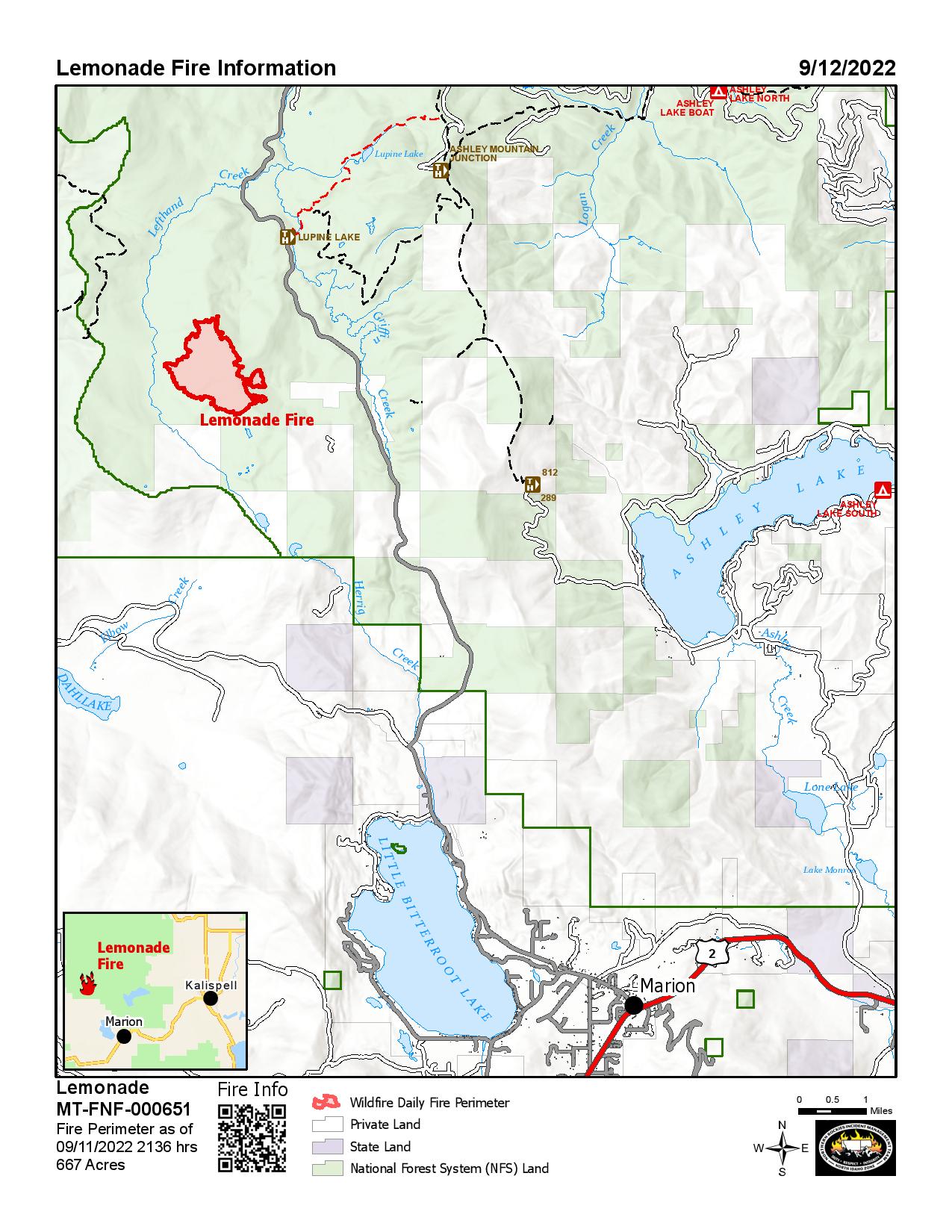
Daily Update September 11 2022
Related Incident: Lemonade Fire
Publication Type: News
Total Acres: 667
Containment: 30%
Start Date: September 1, 2022
Cause: Lightning
Location: 21 miles west of Kalispell near Marion
Personnel: 254
Highlights: The Lemonade Fire has reached 30% containment, with crews continuing to look for areas to fight the fire directly. Firefighters have begun to mop up, or actively cool, remaining heat on the fire’s edge along many places around the perimeter.
Operations: The northeast point of the fire was most active yesterday. Helicopters made water drops while crews constructed handline directly on the fire’s edge. The fire stayed within the indirect heavy equipment line previously built. Today firefighters will seek additional opportunities to go direct in that area.
Crews are doing mop-up from the southwestern point to the middle of the south perimeter. A felling module continues with hazard tree removal to safely allow firefighters to access the fire’s edge. The southeast corner is primarily in patrol status, as crews look for hot spots and mop up where necessary. Firefighters are also hot spotting and mopping up in other areas of the fire on the east and west perimeters.
Weather and Fire Behavior: Temperatures will be 77-82 degrees in the fire area, with 14-19% relative humidity. Winds will be southwest 10-14 with gusts to 18 mph. The fire was most active on the northeast point yesterday, where intense heat remains. There is potential for new spot fires in this area if the southwest winds push embers to the northeast. Moderate or minimal fire behavior is expected around most of the rest of the fire except in places on the south where heat still exists in heavy dead and down material.
Temporary Flight Restrictions: A temporary flight restriction is in place over the fire area, including the use of drones. Remember, if you fly, we can't.
Evacuations: Currently, there are no evacuations; however, one property is under pre-evacuation notice.
Closures: Currently, there are no closures.
Smoke: Visit fire.airnow.gov/ for wildfire smoke information and deq.mt.gov/air/Programs/airquality for Montana Department of Environmental Quality air quality information.
Fire Information Office Hours: 8:00 AM – 8:00 PM
Phone: 406-272-4859| Email: 2022.lemonade@firenet.gov
Online: https://inciweb.nwcg.gov/incident/8379/ | www.facebook.com/discovertheflathead | https://twitter.com/flatheadnf
Daily Update September 10 2022
Related Incident: Lemonade Fire
Publication Type: News
Total Acres: 660
Containment: 15%
Start Date: September 1, 2022
Cause: Lightning
Location: 21 miles west of Kalispell near Marion
Personnel: 270
Highlights: Griffin Creek Road (NFS #538) and Forest Service Trails 210, 211, and 287 are now accessible to the public; however, please avoid unnecessary travel on Griffin Creek Road as there are still fire crews and heavy equipment working in the area. If you use the road, please drive slowly, and watch out for fire personnel.
Operations: An initial fireline is complete around the perimeter of the fire including both handline and machine line. Crews will begin improving and securing the firelines and looking for contingency lines to construct utilizing the heavy equipment. Firefighters will continue to look for hot spots around the fire and identify areas where mop-up can begin. In places on the southern side, crews are mitigating hazard trees so firefighters, skidgens, and engines can safely access the fire's edge. Crews are laying hoses to use water to help mop up and cool the fire.
Weather and Fire Behavior: Today, temperatures will be warmer at 70-75 degrees in the fire area, with 16-21% relative humidity. Winds will be southeast to south 6-8 with gusts to 12 mph. With this wind shift, the most significant area of concern will be on the northeast side, where intense heat remains. Single tree and small group tree torching will continue to occur in areas of heavy dead and down. Plantations of timber will still be areas of much-reduced fire behavior due to limited ground fuels and higher live fuel moisture.
Temporary Flight Restrictions: A temporary flight restriction is in place over the fire area, including the use of drones. Remember, if you fly, we can't.
Evacuations: Currently, there are no evacuations; however, one property is under pre-evacuation notice.
Closures: Currently, there are no closures.
Smoke: Visit fire.airnow.gov/ for wildfire smoke information and deq.mt.gov/air/Programs/airquality for Montana Department of Environmental Quality air quality information.
Fire Information Office Hours: 8:00 AM – 8:00 PM
Phone: 406-272-4859| Email: 2022.lemonade@firenet.gov
Online: https://inciweb.nwcg.gov/incident/8379/ | www.facebook.com/discovertheflathead | https://twitter.com/flatheadnf