
Kootenai River Complex Wildfire Fact Sheet 09042022 IPNF
Related Incident: Kootenai River Complex
Publication Type: Announcement
Kootenai River Complex
Wildfire Fact Sheet
Sunday, Sept. 4, 2022 at 1:00 PM
Kootenai River Complex Fact Sheet 932022 Idaho Panhandle NF
Related Incident: Kootenai River Complex
Publication Type: Announcement
Kootenai River Complex Fact Sheet
Saturday, September 3, 2022
Bonners Ferry Ranger District
Idaho Panhandle National Forests
Inciweb: https://inciweb.nwcg.gov/incident/8378/
Facebook: https://www.facebook.com/USFSIPNF
Public Information Phone: (208) 557-8813
Boundary County Emergency Line: (208) 696-2629
Fire Name: Kootenai River Complex
Location: Bonners Ferry, Idaho
Complexed: September 2, 2022
Cause: Lightning
Size: 6,984 Acres
Containment: 0%
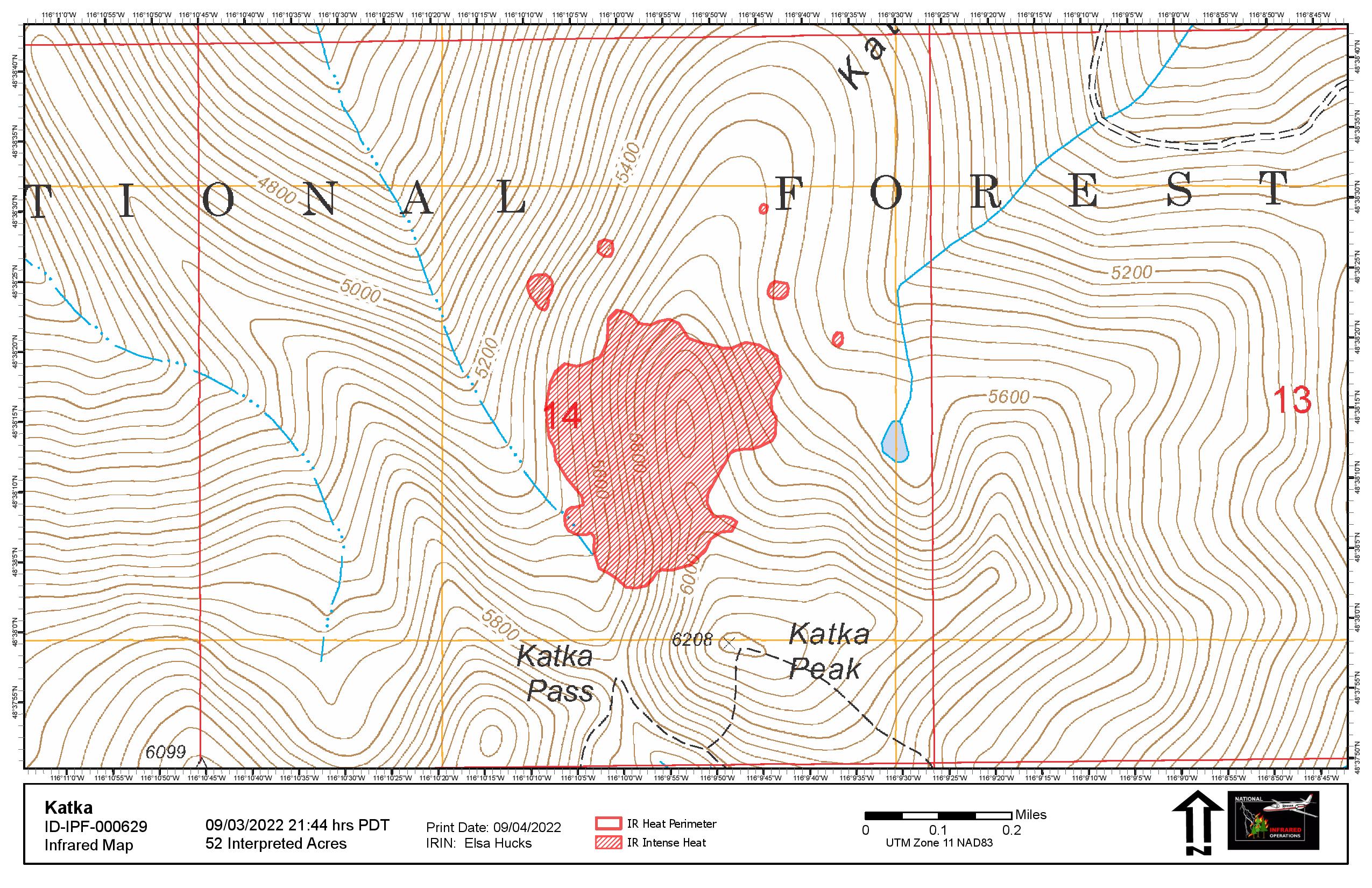
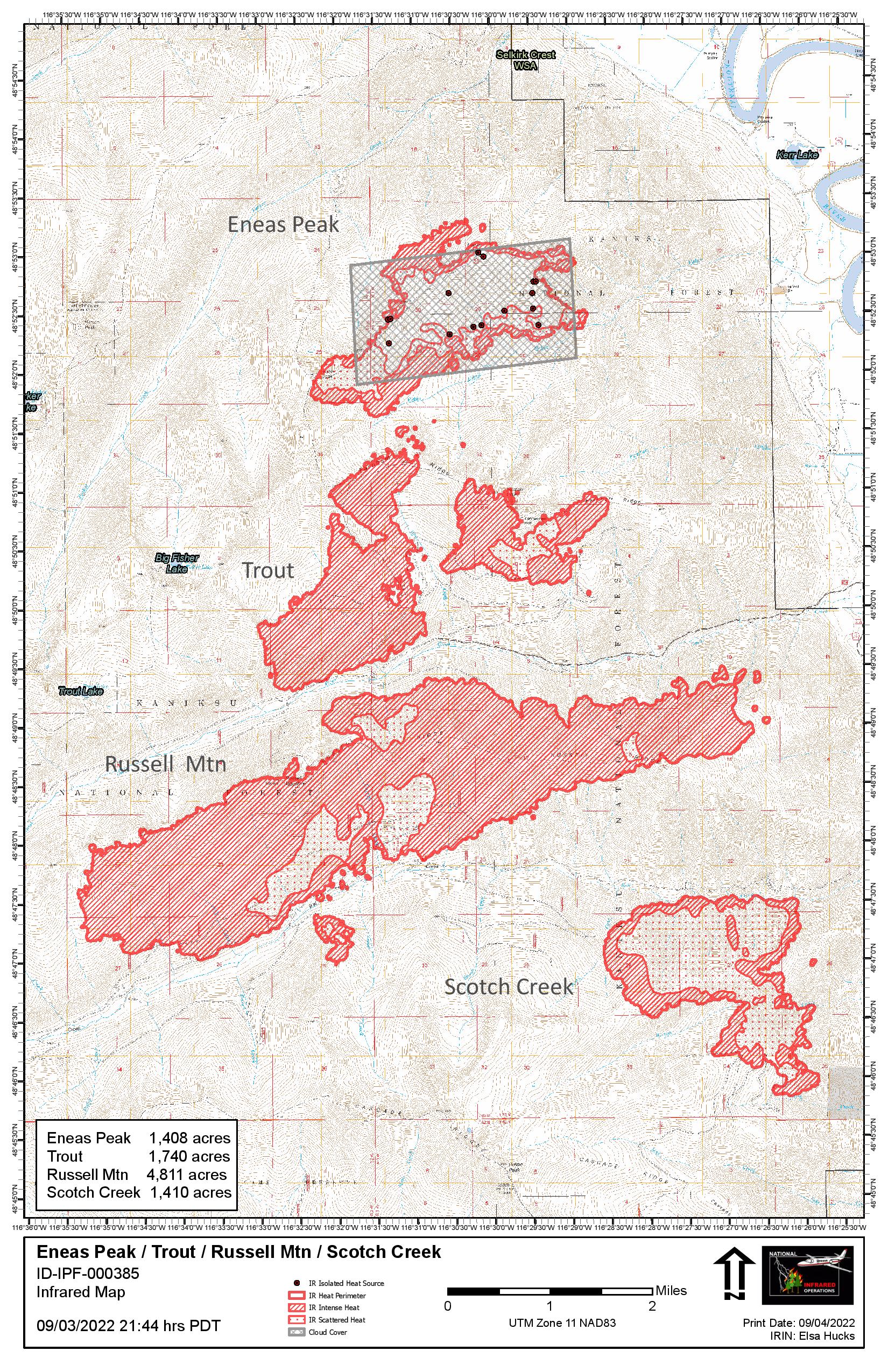
As of 5 pm PDT, on September 2, 2022, the Eneas Peak, Katka, Russell Mountain, Scotch Creek, and Trout Fires have officially been grouped into the Kootenai River Complex. Last night, an infrared detection flight checked the status of existing fires. The Kootenai River Complex has grown 1,547 acres with most growth occurring on the Trout, Russell Mountain, and Scotch Creek Fires. Fire managers continue to assess opportunities to utilize aviation resources to prevent all four fires within the Selkirk Mountains from impacting private land and homes to the east. Engines are working along Westside road to protect private homes, and crews will continue the work into the night. Crews and aviation continue suppression actions on the Katka Fire. Additional resources have been ordered to assist the District. A Northern Rockies Type 2 Incident Management Team will assume command of the fire tomorrow
Closures: Due to fire suppression activities and active fires we advise that visitors avoid Ball Creek Road (FSR 432), Trout Creek Road (FSR 634), and trails. Impacted Trails include Russell Mountain (No. 12), Russell Ridge (No. 92), Ball & Pyramid Lakes (No. 43), Pyramid Pass Trail (No. 13), Pyramid Peak (No. 7), Fisher Peak (No. 27), and Trout Lake (No. 41), McGinty Ridge Trail (143), Clifty Mountain, and Clifty/Burrow Trail (182).
Evacuations: Evacuations: There are NO evacuations currently in place. However, those living on West Side Road closest to Ball Creek, Burton Creek, and Clark Creek have been upgraded to ‘set’ fire evacuation status. “Set” is the last stage of readiness before an actual evacuation takes place. If not voluntarily evacuating already, residents in this stage are advised to at least gather their evacuation supplies together or pre-load them into their vehicles to enable a quick exit if evacuation is advised. When living in fire-prone areas, all residents must have an evacuation plan, including all essential documents, pictures, prescriptions, and pets, and be quickly transportable. Residents of Boundary County, ID, can visit https://www.nixle.com or text their home zip code to 888777 to sign up for emergency alerts. To learn more about Ready Set Go, visit https://bit.ly/3wi0jMu. For tips on defensible space for homes, visit Firewise https://bit.ly/3PALyeG. To prevent unwanted fires, visit the Idaho Department of Lands https://bit.ly/3c4v158.
###No Donations Please
Related Incident: Kootenai River Complex
Publication Type: Announcement
Attention, it has come to our attention that there has been social media posts/conversations about donating to the U.S. Forest Service Fire Management Teams. We greatly appreciate the support and generosity of the community, but we ARE NOT accepting or requesting donations! Our team’s focus is on the mission of fire suppression while keeping firefighter and public safety our number one priority. Our wildland fire crews are well equipped and cared for. However if you are interested in showing support below is a list of ways you can support our team and mission:
Here are some ways you can show support for firefighters.
- Help keep firefighters safe by creating defensible space around your home. Creating defensible space around your home is absolutely the BEST thing you can do to help firefighters. Learn how at http://firewise.org.
- Post thank you banners / signs in the community and on social media. This is a great morale booster for firefighters after a long shift!
- Write thank you notes to firefighters. Drop them off at the incident command post so they can be posted or shared.
- Write thank you letters to firefighters families. Put them in blank, stamped envelopes. After briefings or after shifts, firefighters can address letters to parents, kids, spouses, etc.
We have strict national guidelines for firefighter nutrition. Rest assured, we feed our fire crews three meals a day, including snacks.
Consider a financial contribution to a voluntary organization of your choice. You might consider a donation to:
- Your Local Fire Department
- The Wildland Firefighter Foundation or other firefighter support organization
- The American Red Cross or other community relief organization
- Your local Humane Society or other animal support organization
- Other organizations of your choice
Thank you for your kind consideration!
Magruder Corridor is now open
Related Incident: Twist Creek
Publication Type: Announcement
Magruder Corridor is open! You can travel from Darby, MT to Elk City, ID. The road closure from the Twist Fire has been rescinded. The road is now open again between Observation Point and Sable Saddle. Please note: the area closure for the Indian Ridge fire is still in place.
West Fork Ranger District Fire Update Hunting Season
Related Incident: Twist Creek
Publication Type: Announcement
Hamilton, MT, September 14 — General firearms hunting season in Idaho begins tomorrow, September 15th, and the Bitterroot National Forest is reminding public land users to be aware of ongoing fire activity, especially in Wilderness areas on the West Fork Ranger District. “We recognize that the Selway Bitterroot and Frank Church River of No Return Wilderness Areas provide once in a lifetime hunting opportunity and a place to get away into some peace and quiet. So, we are doing our best to keep that opportunity available while weighing the risks to the public and firefighters in proximity of wildfires” said West Fork District Ranger Dan Pliley.
Currently, there are 12 wildfires burning in the Wilderness areas on the West Fork District. These fires are being managed to provide protection of infrastructure in the developed recreation sites along the Magruder Corridor and Paradise Road. The largest of these fires is the Indian Ridge Fire at roughly 13,000 acres. Last night, the fire reached the road near Magruder Crossing. Current fire activity, rolling debris and falling snags has prompted the temporary closure of the Magruder Corridor north of the Magruder Ranger Station. Fire personnel are working to reopen the road for public travel as soon as conditions allow for safe passage.
The Twist Creek fire, roughly 2,300 acres, is burning near Horse Heaven Cabin and Salmon Base Camp. The fire impacted approximately 2 miles of the road prompting a closure of the Magruder Corridor between Observation Point Campground and Sabe Saddle. Falling teams are working to mitigate fire weakened trees along the road. As conditions allow for safe passage and fire behavior moderates, fire managers will reassess the need for a road closure in this area.
Aside from these two large fires, eight other fires are showing activity and range in size from 100 to 300 acres. Please be aware that these fires are on the landscape and conditions may change rapidly until the area receives moisture.
If you choose to venture into these areas, you need to be flexible. Fires are unpredictable. You may have to change and alter your plans depending on road and trail closures. Additional sections of the roads and areas may be impacted by the fire, causing additional closures and/or delays at any point in time. Firefighters are constantly reviewing the risk to public and fire management to inform any needed closures.
You will notice the recreation sites look a little different. Picnic tables, signs, and outhouses will be bright and shiny as they are wrapped with fire resistant structure wrap. This helps protect them from heat and embers if the fire approaches. Even though they are wrapped, outhouses are likely still open if accessible.
Please know where the fires are and their proximity to you. Stay aware of the conditions on the ground. Be flexible and patient with changes. For more information, visit the Indian Ridge and Twist Creek Fire Inciweb pages, Bitterroot National Forest website and Facebook page. See links below.
Finally, please give the West Fork Ranger District a call at (406) 821-3269 before you come out to check current conditions or new closures.
Inciweb: https://inciweb.nwcg.gov/incident/8319/ (Indian Ridge)
https://inciweb.nwcg.gov/incident/8377/ (Twist Creek)
Bitterroot NF Website: www.fs.usda.gov/bitterroot
Facebook: www.facebook.com/DiscoverBitterrootNF
Twist Creek Fire Emergency Road Closure
Related Incident: Twist Creek
Publication Type: Closures
PROHIBITIONS
Pursuant to 16 U.S.C. § 551 and 36 C.F.R. § 261.50 (b), the following is prohibited on the National Forest System (NFS) road in the West Fork Ranger District, Bitterroot National Forest, described below and shown on the attached map incorporated into this Order as Exhibit A (the “Described Road]”):
1. Being on the Described Road, 36 C.F.R. § 261.54(e).
EXEMPTIONS
Pursuant to 36 C.F.R. § 261.50(e), the following persons are exempt from this Order:
1. Persons with Forest Service Permit No. FS-7700-48 (Permit for Use of Roads, Trails, or Areas Restricted by Regulation or Order), specifically exempting them from this Order or a written determination by a Forest Service authorized officer that a permit is not required under 36 C.F.R. § 251.50(e)(1) or (2)].
2. Any Federal, State, or Local Officer, or member of an organized rescue or firefighting resource in the performance of an official duty 36 C.F.R. § 251.50(e)(4).
DESCRIBED ROAD
Magruder Corridor, Forest Service Road # 468 from the Bitterroot/Nez Perce Clearwater National Forest Boundary at Sabe Saddle east to Observation Point Camp Ground.
PURPOSE
The purpose of this Order is for public health and safety from the effects of the Twist Creek Fire.
IMPLEMENTATION
1. This Order shall be in effect from September 9, 2022 at 0800 through December 31, 2022 at 0800, unless rescinded.
2. A map identifying the Described [Road] is attached and made part of this Order as Exhibit A. For a digital version of this Order and Exhibit A, go to https://www.fs.usda.gov/alerts/bitterroot/alerts-notices
3. Unless otherwise expressly defined in this Order, the terms used in this Order are defined by the regulations of the Secretary of Agriculture, 36 C.F.R. Chapter II, Parts 200-299. If there are terms in this Order that are not expressly defined in the Order or 36 C.F.R. Chapter II, Parts 200-299, their meaning shall be determined by their plain language definitions.
4. A violation of the above prohibitions is punishable as a Class B misdemeanor by a fine of not more than $5,000 for individuals and $10,000 for organizations, or by imprisonment for not more than six months, or both. 16 U.S.C. § 551; 18 U.S.C.
§§ 3559, 3571, and 3581.
5. Contact the West Fork Ranger District in Darby, (406) 821-1226, and Bitterroot National Forest Supervisor’s Office in Hamilton, (406) 363-7100, for more information about this Order.
6. This Order supersedes any previous Orders prohibiting the same or similar acts in the same Described Area and on the same Described Trails.
September 8 2022 Fire Update
Related Incident: Twist Creek
Publication Type: News
The fire became very active Tuesday afternoon and made a large run up Bend Creek crossing the Magruder Corridor east of Horse Heaven Cabin. The fire continued to move north/east yesterday and is now burning along approximately 2 miles of the Magruder Corridor Road. The fire has burned around Horse Heaven Cabin but structure protection and fire personnel were successful at preventing damage to the site. Today fire personnel are working to cut out/clear debris and assess conditions along the road. The Magruder Corridor Road is now closed between Sabe Saddle and Observation Point CG. Road Guards are in place to stop traffic and provide fire information. Red River RD is aware of the closure and has posted maps/info on the western end of the corridor. Fire personnel will continue to assess fire behavior and hazards along the road to determine when public access might be restored. The fire is currently about 2 miles west of Salmon Base Camp.
BREAKING Magruder Road Corridor Currently Closed by Wildfire
Related Incident: Twist Creek
Publication Type: News
Pushed by strong SW/W winds the Twist Creek Fire became very active this afternoon making a run up Bend Creek and crossing the Magruder Road Corridor east of Horse Heaven Cabin.
Due to current and expected fire behavior, fire personnel have implemented a road closure of the Magruder Corridor between Sabe Saddle and Observation Point to ensure public safety.
Magruder Road connecting Darby, MT. and Elk City, ID., is a 101-mile primitive wilderness road.
Tomorrow will be another critical fire weather day requiring the road closure remain in place. If fire behavior moderates later this week, fire managers will look for opportunities to allow traffic through in the mornings.
Visit this site for the latest updates or the Discover Bitterroot National Forest Facebook page at https://www.facebook.com/DiscoverBitterrootNF.
Thank you for your understanding and cooperation!
Twist Creek Update September 2 2022
Related Incident: Twist Creek
Publication Type: News
The Magruder Corridor Road is currently open between Darby and Elk City. However, based on critical fire weather conditions for tomorrow and the potential for increased fire activity on the Twist Fire, south of Sabe Vista and the Cayuse Fire, north of the Hells Half Road, there is a high likelihood that fire personnel may need to temporarily close the Magruder Corridor to ensure public safety. Potential closures for the Twist Fire will be between Sabe Saddle and Salmon Base Camp and potential closures for the Cayuse Fire will be between Magruder RS and Nez Pass. Visitors should be prepared for potential delays that may impact their travel plans and require an extension of their trip or prohibit travel across the entire corridor. For updates on the current status of the Magurder Corridor please refer to this InciWeb page or Discover the Bitterroot Facebook.
Fire Restriction in Effect
Related Incident: Twist Creek
Publication Type: Announcement
Just 11 days after going to “Extreme” fire danger, the highest level possible, the Bitterroot National Forest (BNF) announced today that it is implementing Stage 2 Fire Restrictions beginning tomorrow, due to our hot temperatures and dry fuel conditions.
“We will be moving directly into Stage 2 fire restrictions this season,” said Mark Wilson, Fire Management Officer. “We decided not to implement Stage 1 restrictions and immediately go to the highest level because we currently meet the conditions for Stage 2.”
Current conditions across the forest are at our maximum recorded values with the start of August. Short and long-term forecasts indicate sustained weather conditions that support continued significant fire behavior through mid-September
“With current fire activity and predicted weather, we all need to do everything we can to prevent additional wildfires from starting,” stated Matt Anderson, Bitterroot National Forest Supervisor. “We are asking the public to recreate responsibly and adhere to these restrictions.”
Fire restrictions are intended to decrease the chance of preventable, human-caused fires in the designated areas.
Stage II Fire Restrictions will be effective Friday, August 12, at 12:01 a.m. for all Bitterroot National Forest lands in Montana,including the Anaconda Pintler and Selway-Bitterroot Wilderness Areas in Montana.
STAGE II FIRE RESTRICTIONS: Under the Stage II Fire Restrictions, the following acts are prohibited on federally managed or protected lands, roads, and trails:
1. Building, maintaining, attending, or using a fire or campfire.
2. Smoking, except within an enclosed vehicle or building, a developed recreation site, or while stopped in an area at least three feet in diameter that is barren or closed of all flammable materials.
3. Operating a chainsaw or other equipment powered by an internal combustion engine (prohibited 1:00 p.m. to 1:00 a.m).
4. Welding or operating an acetylene or other torch with open flame.
5. Operating motorized vehicles off designated roads and trails.
Exemptions:
1. Persons with a Forest Service special use authorization, or other authorization specifically exempting them from the effect of this Order. If the authorization allows operation of an Internal Combustion Engine or welding or operating an acetylene or other torch with open flame, such acts are prohibited from the hours of 1:00 p.m. to 1:00 a.m. Outside of these hours; a one-hour foot patrol in the work area is required following cessation of these activities.
2. Persons using a device solely fueled by liquid petroleum or LPG fuels that can be turned on and off. Such devices can only be used in an area that is barren or cleared of all overhead and surrounding flammable materials within three feet of the device.
3. Operating generators with an approved spark arresting device within an enclosed vehicle or building or in an area that is barren or cleared of all overhead and surrounding flammable materials within three feet of the generator.
4. Operating motorized vehicles on designated roads and trails.
5. Emergency repair of public utilities and railroads conducted.
6. Persons conducting activities in those designated areas where the activity is specifically authorized by written posted notice.
7. Any Federal, State, or local officer, or member of an organized rescue or firefighting force in the performance of an official duty.
8. All land within a city boundary is exempted.
Anyone caught violating the restrictions could be fined up to $5,000 and face up to 6 months in jail. They may also be held liable for all suppression costs and damages if they start a fire. Visit www.mtfireinfo.org to learn more about current fire restrictions in place throughout Montana.
BNF wilderness areas in Idaho including the Selway-Bitterroot and Frank Church River of No Return are not included in the fire restrictions at this time. See forest map for more details.
The ridge of high pressure that is bringing our hot temperatures is also transporting smoke from wildfires in Idaho, Oregon, and California causing hazy skies and smoke impacts. For the latest air quality information visit http://svc.mt.gov/deq/todaysair. This site displays particulate concentrations and health effects including a daily ‘Wildfire Smoke Update’.
For more information about fires in Montana and other fires across the country, visit http://inciweb.nwcg.gov or follow us on Facebook at www.facebook.com/DiscoverBitterrootNF for local fire information.
This summer, there have been 27 wildfires on the Bitterroot National Forest; 9 human-caused and 18 lightning fires.
###
USDA is an equal opportunity provider, employer and lender.