
Ross Fork Fire Daily Update Thursday September 8
Related Incident: Ross Fork
Publication Type: News
Ross Fork Fire Daily Update September 8, 2022
Fire Information: Email: 2022.rossfork@firenet.gov Phone: 208-329-6044 daily from 7 a.m. - 9 p.m.
Sawtooth National Forest Facebook: https://www.facebook.com/sawtoothnationalforest
Inciweb: https://inciweb.nwcg.gov/incident/8375
Containment: 2%
Cause: Lightning
Acreage: 28,874 Acres
Location: Sawtooth National Forest, Idaho
Fuel Type: Timber Litter/Timber/Short Grass
Another red flag warning is in effect today, which could result in more extreme fire behavior. Wednesday’s fire activity forced the closure of Highway 75 (between mile markers 146 to 172) because of the fire’s proximity to the road and heavy smoke. The fire was very active near Alturas Lake and in the Smiley and Beaver Creek drainages. There are no reports currently of additional structures lost, but fire activity was so intense in some areas that firefighters had to withdraw to their safety zones. There was one small spot fire north of the road to Alturas Lake near Perkins but firefighters, with the help of helicopters dropping water, were able to contain it. With gusts over 25 mph predicted today, embers could spot ahead of the main fire at distances up to 4500 feet.
Additional firefighting resources continue to arrive to support suppression efforts. However, with numerous large fires in the region, not all requested resources are available. Ten helicopters as well as four scooper planes have been flying as often as conditions permit and will be available again today. Firefighters will continue to directly engage the fire when and where it is safe to do so. Deputy Incident Commander Sam Hicks says, “We will continue to work in the right place, at the right time, giving us the most opportunity for success. We understand the importance of the Highway 75 corridor to the residents of this area and we will work to keep it open, when it is safe for both firefighters and the public to do so.”
TRAFFIC AND DRIVING CONDITIONS: HWY 75 may be closed intermittently for public and firefighter safety. The latest updates on road closures can be found at https://511.idaho.gov/
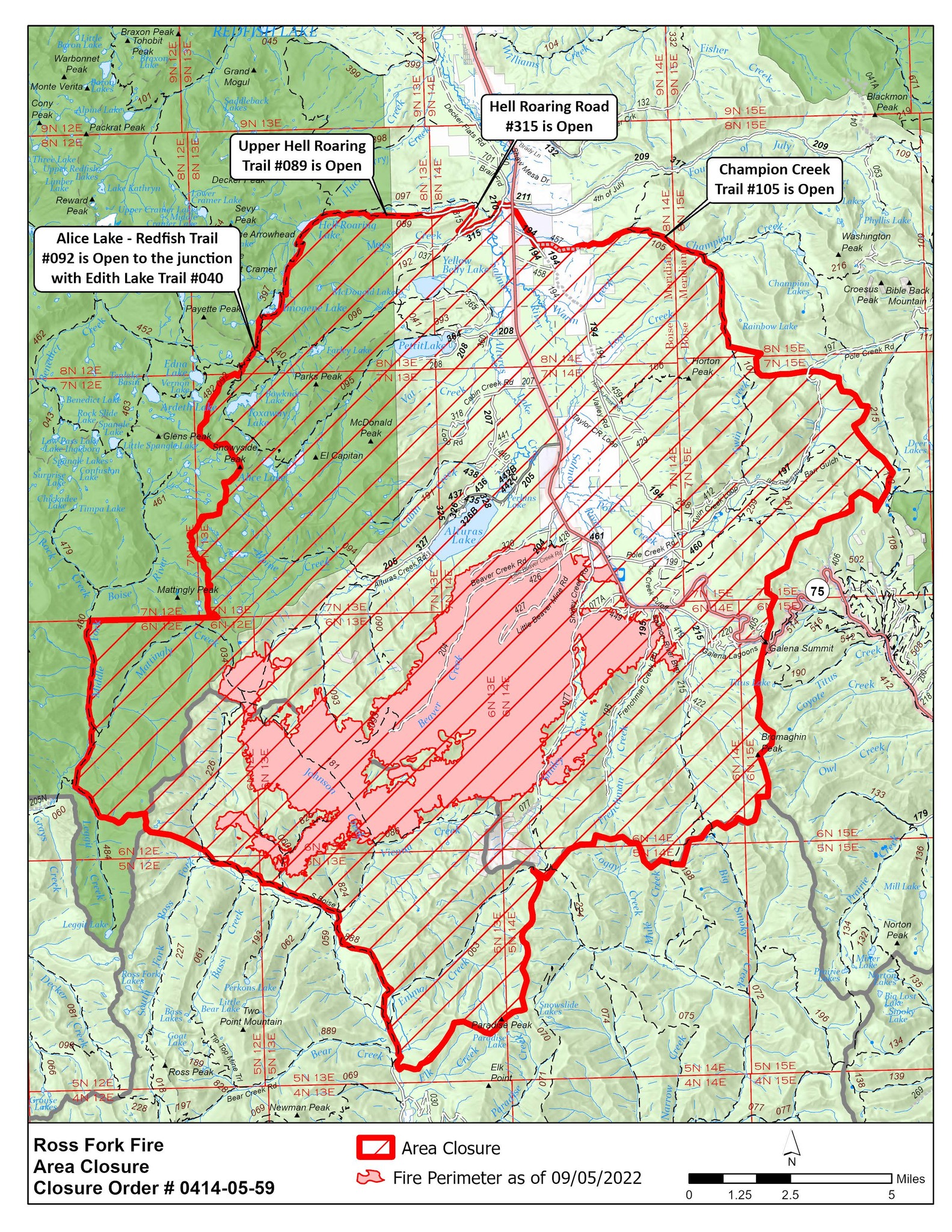
CLOSURES AND RESTRICTIONS: Closure order 0414-05-059 has been issued by the Sawtooth National Forest for the areas surrounding the #RossForkFire on the Sawtooth National Recreation Area AND Fairfield Ranger District to protect public safety and natural resources on roads and trails. For more information, please visit https://www.fs.usda.gov/alerts/sawtooth/alerts-notices.
EVACUATIONS: The Blaine County Sheriff has placed Petitt Lake Road, Cabin Creek Road, Smiley Creek, Sawtooth City and Alturas Lake in a “GO” evacuation status, which means evacuate now. Updates from the Blaine County Sheriff’s Office can be found at https://www.blainesheriff.com/152/Sheriff or on the Blaine County Sheriff Facebook page. The fire remains very active and all residents in proximity of the fire should follow local emergency information sources and be prepared to evacuate, if asked to do so.
TOTAL FIRE RESOURCES ASSIGNED:
Personnel
493,
Hand Crews
11,
Engines
30,
Helicopters
10
Visit our website at: www.fs.usda.gov/Sawtooth and on Facebook at: https://www.facebook.com/sawtoothnationalforest
New Evacuation Order for Pettit Lake Rd and Cabin Creek Rd Areas
Related Incident: Ross Fork
Publication Type: Announcement
9/7/2022 5 p.m.
Level 3 Mandatory Evacuation is NOW ORDERED for the Pettit Lake Rd. and Cabin Creek Rd. Areas of the Ross Fork Fire.
LEAVE IMMEDIATELY
Mandatory Evacuation remains in place for Smiley Creek, Sawtooth City, Beaver Creek, and Alturas Lake. Hwy 75 is CLOSED from Prairie Creek Road to the Blaine/Custer County Line (Milepost 146-172).
Ross Fork Fire Area Closure Version 3 September 6
Related Incident: Ross Fork
Publication Type: Closures
Order Number: 0414-05-057
UNITED STATES DEPARTMENT OF AGRICULTURE
FOREST SERVICE
SAWTOOTH NATIONAL FOREST FAIRFIELD RANGER DISTRICT &
SAWTOOTH NATIONAL RECREATION AREA
National Forest Area, Road, and Trail Closure (For Public Safety)
Ross Fork Fire – Version 3
PROHIBITIONS:
Pursuant to 16 U.S.C. § 551 and 36 CFR 261.50 (a) and (b), the following act is prohibited on the National Forest System (NFS) lands and trails within the Fairfield Ranger District, Sawtooth National Forest, described below and shown on the attached map incorporated into this Order in Exhibit A (“Closed Area” and “Closed Trails”):
- Going into or being upon the Closed 36 CFR 261.52(e), 261.53(e)
- Being on the Roads described below. 36 CFR 261.54(e)
- Being on the Trails described below. 36 CFR55(a)
EXEMPTIONS:
Pursuant to 36 CFR 261.50(e), the following persons are exempt from this Order:
- Persons with a special use authorization or other Forest Service authorization specifically exempting them from the effect of this Order.
- Any Federal, State, or local officer, or member of an organized rescue or fire fighting force in the performance of an official duty.
- Federal or State administrative personnel in the performance of an official
CLOSED AREA AND TRAILS DESCRIPTION:
The Closed Area is within the Fairfield Ranger District, Sawtooth National Forest, Camas County, Idaho, Boise Meridian and the Sawtooth National Recreation Area, Sawtooth National Forest, Blaine and Custer Counties, Idaho, Boise Meridian. The Closed Area is all NFS lands within the following boundaries:
- Beginning at the bridge over the South Fork of the Boise River, National Forest Road #079, Section 34, T5N, R13E, and continuing north by northwest along and including the Ross Fork Jeep Trail #888 to its intersection with the North Fork Ross Trail #226 in Section 2, T5N, R12E;
- Continuing to the north along and including the North Fork Ross Trail #226 for ½ mile in Section 35, T6N, R12E; Then following the ridgeline to the west in Sections 35 and 34 to the administrative boundary of the Fairfield Ranger District and the Sawtooth Wilderness at Rossview Peak in Section 34, T6N, R12E;
- Continuing west and following a perennial stream that drains into Leggit Creek to the Leggit Creek Trail #484 in Section 33, T6N, R12E;
- Continuing north along and including Leggit Creek Trail #484 to the intersection with Middle Fork Boise River Trail #460;
- Continuing north along and including the Middle Fork Boise River Trail #460 to the dividing line between Section 5, T6N, R12E and Section 34, T7N, R12E about ¾ miles south by southwest from the intersection of Middle Fork Boise River Trail #460 and Timpa Creek Trail #479;
- Continuing east along the dividing line between T6N, R12E at Section 5 and T7N, R12E at Section 34 to National Forest boundary in Section 31, T7N, R13E;
- Continuing north along the National Forest Boundary to the junction with Alice Lake-Redfish Trail #092 in Section 32 T8N, R13E;
- Continuing north northeast along Alice Lake-Redfish Trail #092 to the junction with Upper Hellroaring Trail #089 in Section 14, T8N, R13E;
- Continuing west along the Upper Hellroaring trail 089 to the junction with Hellroaring Road #315 in Section 18, T8N, R14E;
- Continuing west along Hellroaring road 315 to the junction with State Highway 75 where Sections 8, 9, 16 and 17 join in T8N, R14E;
- Continuing due south on State Highway 75 about ½ mile to the junction with Champion Creek in Section 16, T8N, R14E;
- Continuing south and east along Champion Creek to where the creek intersects Trail 107 in Section 19, T8N, R15E;
- Continuing south along Trail 107 to the headwaters of the South Fork of Champion Creek approximately 2 miles at Section 5, T7N, R15E;
- Continuing due east approx. ½ mile to the boundary between Big Game Management Units 36 and 36A;
- Continuing following the Big Game Unit Boundary south across State Highway 75 near the Galena Summit in Section 7, T6N, R15E to the Sawtooth National Recreation Area boundary in Section 30, T6N, R15E;
- Continuing west along the Sawtooth National Recreation Area boundary to the junction with the Emma Creek Trail #063 in Section 6, T5N, R14E;
- Continuing south along the watershed divide of Emma Creek and the West Fork of Big Smoky Creek to Paradise Peak, Section 25, T5N, R13E;
- Continuing westerly along the watershed divide of Emma Creek and Elk Creek to South Fork of the Boise River in Section 34, T5N, R13E;
- Continuing north along the South Fork Boise River to the point of origination on Forest Road #079 at the bridge of the South Fork of the Boise River in Section 34, T5N, R13E.
The Closed Trails are all NFS Trails or portions of NFS Trails within or bordering the Closed Area: #033, #034, #040, #041, #060, #063, #072, #086, #090, #092, #093, #094, #095, #096, #097, #106, #107, #112, #117, #181, #191, #192, #198, #224, #226, #227, #256, #257, #258, #259, #261, #264, #265, #393, #397, #403, #404, #460, #484, #514, #824, #825, #888.
The Closed Roads are all NFS Roads or portions of NFS Roads within or bordering the Closed Area: #037, #077, #194, #195, #197, #199, #204, #205, #207, #208, #209, #210, #215, #220, #316, #318, #320, #324, #325, #326, #327, #328, #329, #360, #361, #362, #363, #364, #365, #367, #402, #405, #410, #412, #414, #417, #419, #422, #426, #427, #428, #429, #430, #435, #436, #437, #438, #439, #440, #441, #442, #443, #445, #446, #449, #458, #459, #460, #461, #077A, #205A, #205B, #207A, #326A, #326B, #440A, #440B, #442A, #442B, #442C, #442D, #446A.
PURPOSE:
To protect public safety during active firefighting operations.
IMPLEMENTATION:
- This Order will be in effect September 6, 2022, at 10:00 M. and shall remain in effect until November 15, 2022, at 5:00 P.M.
- A map identifying the Closed Area is attached and made part of this
- A violation of the above prohibition(s) is punishable by a fine of not more than
$5,000 for an individual or $10,000 for an organization, imprisonment for not more than six months, or both. [16 U.S.C § 551, 18 U.S.C §§ 3559, 3571, 3581].
- Further information regarding this Order may be obtained at the Fairfield Ranger District (208) 764-3202 and the Sawtooth Forest Supervisor’s Office (208) 423- 7500 in Twin Falls, ID.
Done at Jerome, Idaho this 6thday of September 2022.
REBECCA HOTZE
Acting Forest Supervisor, Sawtooth National Forest
Ross Fork Fire Daily Update Wednesday September 7
Related Incident: Ross Fork
Publication Type: News
Ross Fork Fire Daily Update, September 7, 2022
Fire Information: Email: 2022.rossfork@firenet.gov Phone: 208-329-6044 daily from 7 a.m. - 9 p.m.
Sawtooth National Forest Facebook: https://www.facebook.com/sawtoothnationalforest
Inciweb: https://inciweb.nwcg.gov/incident/8375
Containment: 2%
Cause: Lightning
Acreage: 28,874
Location: Sawtooth National Forest, Idaho
Fuel type: Timber Litter/Timber/Short Grass
A community meeting will be held for the Ross Fork Fire at the Stanley Ranger Station, on Wednesday, September 7 at 6:00 p.m. 442 Ranger Station Rd., Stanley, ID 83278. If you would like to attend virtually, please use the following Zoom link:
https://www.zoomgov.com/j/1608517516?pwd=OTU4NGxxd1l2dDdUdDNSZGZYdWc5Zz09 No password is required.
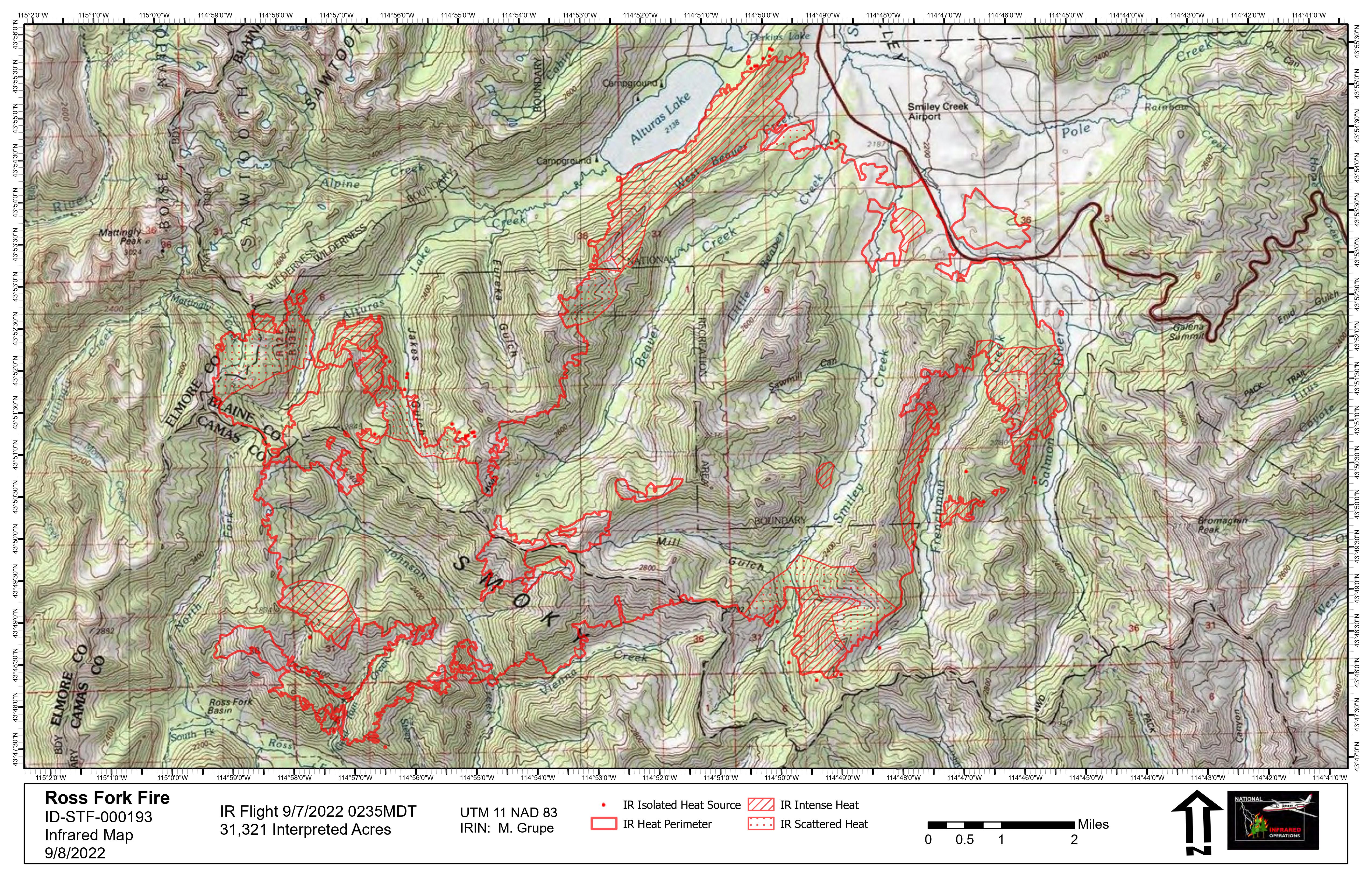
The fire grew over 4000 acres in the past 24 hours as measured by an infrared mapping flight overnight. The fire is 2% contained, and that number is lower because of the growth in the size of the overall perimeter. A red flag warning has been issued today, this could result in extreme and erratic fire behavior due to strong winds, high temperatures and very dry fuel conditions. Today, firefighters will continue to protect structures in the Smiley Creek subdivision as well as prepare firelines across the area to protect homes, campgrounds and other structures and to increase containment where possible. Yesterday the fire did jump across Highway 75 south of Smiley Creek but the wind died down and firefighters, with the help of aircraft, worked to contain this 800 acre “spot” fire. They will be working today to secure that area and prevent further spread in that area.
At 6:00 a.m. this morning, Great Basin Incident Management Team 3 assumed command of the firefighting efforts. The Type 3 team which had been managing the fire will continue to assist the new team. “Firefighting resources are at a premium across the region because of multiple large fires,” says Great Basin Incident Commander Marty Adell. “We appreciate the strong work from the many cooperating local agencies and the Type 3 team and, with their help, we will continue the work to protect this valuable national resource and the private properties around it.”
TRAFFIC AND SMOKE CONDITIONS: Highway 75 reopened last night but please be aware that conditions can change rapidly. Heavy smoke may also be an issue across the area. The latest updates on road closures can be found at https://511.idaho.gov/ Information on smoke conditions is at airnow.gov
CLOSURES AND RESTRICTIONS: Closure order 0414-05-059 has been issued by the Sawtooth National Forest for the areas surrounding the #RossForkFire on the Sawtooth National Recreation Area AND Fairfield Ranger District to protect public safety and natural resources on roads and trails. For more information, please visit https://www.fs.usda.gov/Internet/FSE_DOCUMENTS/fseprd1058641.pdf.
EVACUATIONS: The Blaine County Sheriff has placed Smiley Creek, Sawtooth City and Alturas Lake in a “GO” evacuation status, which means evacuate now. The latest updates from the Blaine County Sheriff’s Office can be found at https://www.blainesheriff.com/152/Sheriff. The fire remains very active and all residents in proximity of the fire should follow local emergency information sources and be prepared to evacuate, if asked to do so.
TOTAL FIRE RESOURCES ASSIGNED:
Personnel
366
Hand Crews
7
Engines
23
Helicopters
10
Visit our website at: www.fs.usda.gov/Sawtooth and on Facebook at: #RossForkFire
Ross Fork Fire Community Meeting Wed Sept 7 6pm Stanley Ranger Station
Related Incident: Ross Fork
Publication Type: Announcement
A community meeting will be held on Wednesday, September 7 at 6 p.m. at the USFS Sawtooth Recreation Area Ranger Station. The Ranger station is located on the west side of Highway 75, approximately 2 1/2 miles south of Stanley, Idaho. Officials will provide information and updates regarding the Ross Fork Fire.
The meeting will also be streamed to Zoom so it can be watched remotely. If you have questions about the fire you can ask them during the meeting on Zoom, or email them in advance to 2022.rossfork@firenet.gov. We will answer as many as we can during the meeting.
We hope you join us.
This is the link to the Zoom meeting:
https://us02web.zoom.us/j/84827036738?pwd=bFY2V2prRisreTFTbTNmcm44R2J4dz09
Meeting ID: 848 2703 6738
Passcode: 549497
Ross Fork Fire Daily Update Tuesday September 6
Related Incident: Ross Fork
Publication Type: News
Ross Fork Fire Daily Update
September 6, 2022
Fire Information: Call 208-329-6044
Containment: 4%
Cause: Lightning
Acreage: 24,026
Location : 6 miles East of Atlanta, ID
Fuel type: Timber Litter, Timber, and Short Grass
The Ross Fork Fire is currently transitioning from a Type 3 Incident Command Team (under the direction of IC Scott Stephenson) to a Type 2 Incident Command Team. Great Basin Team 3, under the direction of Incident Commander Marty Adell, transfer of command will take place 09/07/22 at 0600.
The fire is 24,026 acres and is 4% contained. Fire activity continued to be extreme with continued hot and dry winds. The fire continued down the Beaver Creek drainage towards Alturas Lake in a North East direction. The fire also progressed down the Smiley Creek drainage and is threatening the community of Smiley. There is also a spread to the East throughout the Frenchman Creek drainage, currently threatening the Salmon River headwaters.
Today crews will be working to keep the fire from crossing HWY 75, evaluating options to control the Salmon River drainage spread, and continue with structure defense in the community of Smiley. Crews are also evaluating tactical options for the fire above Alturas Lake as it progresses to the North towards the HWY 75 and further areas.
Residents and visiting public should keep informed of fire progress in Smiley Creek, Alturas Lake, and adjacent areas. Use #RossForkFire on Facebook at https://www.facebook.com/sawtoothnationalforest and on Twitter at https://twitter.com/SawtoothNatlFS Find air quality conditions at: https://www.airnow.gov/?city=Ketchum&state=ID&country=USA
CLOSURES AND RESTRICTIONS: Access to the following lakes and drainages are CLOSED as of 08:00 this morning: Pettit Lake and Trailhead, Yellowbelly Lake, Pole Creek, Upper Salmon River Headwaters, Frenchman Creek, and Alturas Lake. A closure order was issued by the Sawtooth National Forest for the areas surrounding the #RossForkFire on the Sawtooth National Recreation Area (0414-05-058) AND Fairfield Ranger District (0414-05-057) to protect public safety and natural resources on roads and trails.
The public is urged to please stay out of the fire area.
You can read both closures in their entirety at https://www.fs.usda.gov/alerts/sawtooth/alerts-notices
MAPS: Please visit the Ross Fork Fire’s Inciweb page at https://inciweb.nwcg.gov/incident/maps/8375
9422 Level 3 MANDATORY Evacuation Notice
Related Incident: Ross Fork
Publication Type: News
Blaine and Custer County personnel are evacuating residents of Smiley Creek, Sawtooth City, and Alturas Lake due to fire activity picking up in Beaver Creek drainage. This is a Level 3 Go Mandatory Evacuation. LEAVE IMMEDIATELY. Level 3 Means GO! The danger is current or imminent to your area. DO NOT delay to gather belongings. Entry to evacuated areas may be denied until safe.
Read the original Facebook post from Blaine County Sheriff's Department at https://m.facebook.com/story.php?story_fbid=446441974178117&id=100064369556920&sfnsn=mo.
9422 Level 1 PreEvacuation Notice for Sawtooth CityAlturas Lake areas
Related Incident: Ross Fork
Publication Type: News
The Ross Fork Fire is exhibiting very active fire behavior driven by warm, dry, and windy weather. Please be aware that Blaine County Sheriff in cooperation with the USDA Forest Service is issuing a Level 1 (Pre-Evacuation) Notice for all campgrounds and cabins from Sawtooth City (Smiley Creek) to Alturas Lake due to increased fire activity in the Ross Fork Fire. This includes the Beaver Creek area.
Level 1 means you should be aware that danger exists in your area and begin preparations to evacuate if necessary. Anyone with special needs, mobile property, livestock or pets should begin moving out of the area.
Fire managers are closely monitoring the Ross Fork Fire. Please maintain situational awareness at all times. If you are in danger do not wait for an evacuation order -LEAVE IMMEDIATELY.
Read the original Facebook post from Blaine County Sheriff's Department at https://m.facebook.com/story.php?story_fbid=446341664188148&id=100064369556920.
Order 41405057 National Forest Area and Trail Closure
Related Incident: Ross Fork
Publication Type: Closures
Order Number: 0414-05-057
UNITED STATES DEPARTMENT OF AGRICULTURE FOREST SERVICE
SAWTOOTH NATIONAL FOREST FAIRFIELD RANGER DISTRICT
National Forest Area and Trail Closure (For Public Safety)
Ross Fork Fire
PROHIBITIONS:
EXEMPTIONS:
CLOSED AREA AND TRAILS DESCRIPTION:
PURPOSE:
IMPLEMENTATION:
1. This Order will be in effect August 17, 2022, at 2:00 P.M. and shall remain in effect until November 15, 2022, at 5:00 P.M.
4. Further information regarding this Order may be obtained at the Fairfield Ranger District (208) 764-3202 and the Sawtooth Forest Supervisor’s Office (208) 423- 7500 in Twin Falls, ID.
Done at Jerome, Idaho this 17th day of August 2022.
Scotch Fire Change
Related Incident: Scotch Fire
Publication Type: News
The Scotch Fire is now the Kootenai River Complex. Click here for information.
Kootenai River Complex link: https://inciweb.nwcg.gov/incident/8378/