
Second Drone Incursion on Ross Creek Fire
Related Incident: Ross Fork
Publication Type: News
Recently, there have been two drone incursions on the Ross Fork Fire. One of the drones came extremely close to a helicopter while it was in flight. Flying a drone near a wildfire is dangerous and can cost lives. Firefighting aircraft fly at very low altitudes, typically just a couple of hundred feet above the ground, the same altitude as drones flown by members of the public. When people fly drones near wildfires, the incident grounds firefighting aircraft to avoid the potential for a midair collision. Delaying airborne response poses a threat to firefighters on the ground, residents and property in nearby communities, and it can allow wildfires to grow larger. If You Fly, We Can’t.
The Federal Aviation Administration has a Temporary Flight Restriction in place for the Ross Fork Fire https://tfr.faa.gov/save_pages/detail_2_2381.html. All aircraft, including drones, are prohibited from flying in the restricted area unless they’re operated by an agency that’s involved in the firefighting operation. It’s a federal crime, punishable by up to 12 months in prison, to interfere with firefighting efforts on public lands. Additionally, Congress has authorized the FAA to impose a civil penalty of up to $20,000 against any drone pilot who interferes with wildfire suppression, law enforcement or emergency response operations.
If you see a drone flying in the area of the Ross Fork Fire, please report it immediately to the Blaine County Sherriff’s Department and the Boise FAA Flight Standards District Office at 208-387-4000 with as much information as possible. Thank you for your assistance.
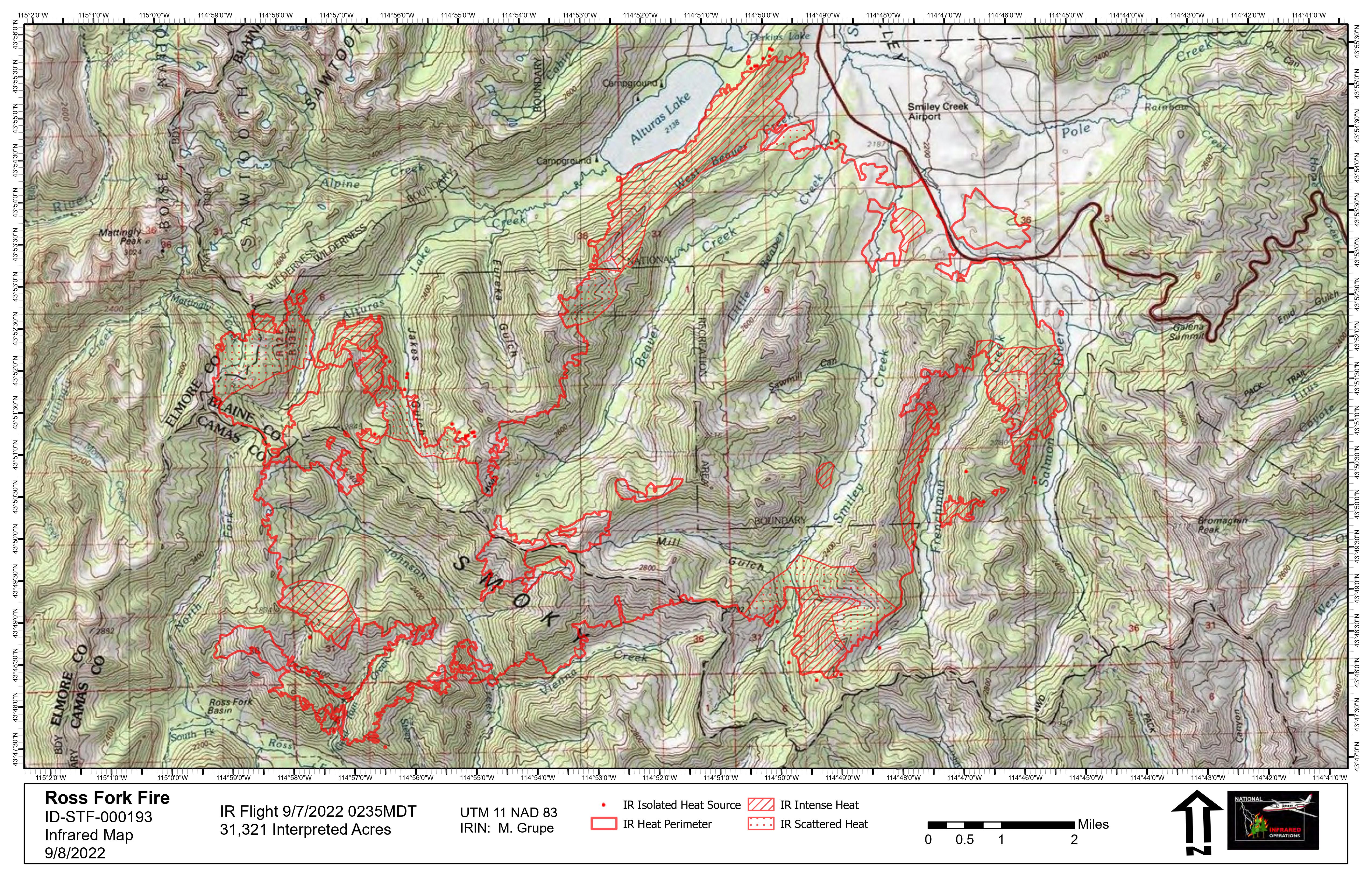
Ross Fork Fire Daily Update Monday September 12
Related Incident: Ross Fork
Publication Type: News
Ross Fork Fire Daily Update
September 12, 2022
Fire Information: Email: 2022.rossfork@firenet.gov
Phone:208-329-6044 daily from 8 a.m. - 8 p.m.
Sawtooth National Forest Facebook: https://www.facebook.com/sawtoothnationalforest
YouTube:https://youtu.be/Ll7iJz55hnIInciweb: https://inciweb.nwcg.gov/incident/8375
Containment: 13%
Cause: Lightning
Acres: 37,233
Location: Sawtooth National Forest, Idaho
Fuel Type: Timber Litter/Timber/Short Grass
Containment of the Ross Fork Fire increased to 13 percent Sunday after firefighters worked for several days to secure portions of the fire line in the Highway 75 corridor near Smiley Creek. Fire managers are optimistic they will add to that containment percentage as resources shift south along the highway and move down Forest Road 215. Day and night shift resources continue to patrol and “mop up” hot spots along the perimeter. The Galena Lodge, as well as many other public and private structures, are being “prepped” in case the fire moves towards them. Prepping can include installing water sources, hoses, and sprinklers, as well as vegetation thinning.
A temperature inversion that had trapped smoke in the Stanley Valley lifted late Sunday afternoon. As expected, fire activity did pick up after the smoke cleared but helicopters were also able to fly in the clear air. Water buckets were dropped near Vienna Creek and the Headwaters of the Salmon River to decrease the fire’s intensity and slow its rate of spread. A drone incursion was reported at Smiley Creek Sunday and air operations had to briefly shut down as a result. Residents and travelers are reminded that there is a temporary flight restriction in place over the fire area and neither drones nor aircraft are permitted within that restricted area.
The Incident Meteorologist is predicting a good chance that moisture will begin moving into the area Tuesday afternoon with rain possible at times through the end of the week. Fire managers are hopeful the rain will arrive but will continue structure protection, fire suppression and planning to be ready in case the rain does not arrive.
The USDA Forest Service and Idaho Department of Lands has initiated Stage 1 fire restrictions on the Sawtooth North Zone, effective Sunday, September 11. The full order, which encompasses lands north of Highway 20 to the northern most Sawtooth National Forest boundary situated in Blaine, Camas, and portions of Custer, Elmore, and Boise counties, can be found at: https://www.fs.usda.gov/Internet/FSE_DOCUMENTS/fseprd1059189.pdf. Stage 1 fire restrictions apply to all state, state endowment, and private land in the North Zone that lie within the boundary of the Sawtooth National Forest.
TRAFFIC AND DRIVING CONDITIONS: Highway 75 has been open continuously for the past four days but still may be subject to intermittent safety closures. Updated road information is at https://511.idaho.gov/.
CLOSURES AND RESTRICTIONS: Closure order 0414-05-059 has been issued by the Sawtooth National Forest for areas surrounding the #RossForkFire on the Sawtooth National Recreation Area AND Fairfield Ranger District. Visit https://www.fs.usda.gov/alerts/sawtooth/alerts-notices, for more information.
AIR QUALITY: Wildfire smoke can be hazardous to your health. For more information, please visit: https://www.airnow.gov
EVACUATIONS: The Galena area is in “SET” evacuation status, meaning residents should be ready to leave on short notice. Pettit Lake Road, Cabin Creek Road, Smiley Creek, Sawtooth City and Alturas Lake remain in “GO” evacuation status, which means evacuate now. Updates from the Blaine County Sheriff’s Office are at https://www.blainesheriff.com/152/Sheriff or on the Blaine County Sheriff Facebook page.
TOTAL FIRE RESOURCES ASSIGNED:
Personnel
712,
Hand Crews
14,
Engines
52,
Helicopters
9
Visit our website at: www.fs.usda.gov/Sawtooth and on Facebook at: https://www.facebook.com/sawtoothnationalforest
Ross Fork Fire Daily Update Sunday September 11
Related Incident: Ross Fork
Publication Type: News
Ross Fork Fire Daily Update
September 11, 2022
Fire Information: Email: 2022.rossfork@firenet.gov Phone:208-329-6044 daily from 7 a.m. - 9 p.m.
Sawtooth National Forest Facebook: https://www.facebook.com/sawtoothnationalforest
YouTube:https://youtu.be/Ll7iJz55hnIInciweb: https://inciweb.nwcg.gov/incident/8375
Containment: 2%
Cause: Lightning
Acreage: 36, 717 Acres
Location: Sawtooth National Forest, Idaho
Fuel Type: Timber Litter/Timber/Short Grass
Thick smoke across the Ross Fork Fire area will continue to limit fire growth again today but if the smoke clears, we may see active fire behavior this afternoon. The smoke has put a damper on the fire for the past two days, allowing firefighters to make great progress securing the edges of the perimeter, especially on the eastern side. Crews will “mop-up” those edges today, from Alturas Lake and south, along the South Fork of the Salmon River. Mop-up is the process of extinguishing all heat sources along as much of the edge as they can safely reach, to create a line to stop additional growth. Hotshot crews are hiking into the forest above the Headwaters of the Salmon River to look for opportunities to stop the fire there. Crews continue to look for and contain any small spot fires on the east side of the Salmon that were caused by embers last Thursday.
Successful completion of a burnout—a process that removes unburned fuel to stop fire progression—was achieved yesterday near the Alturas Creek Road and Highway 75 junction. Crews will patrol and mop-up the edge of the burnout to look for and extinguish any additional heat sources. This burnout is meant to stop future fire spread to the north and east. However, preparations to protect structures in Cabin Creek, Pole Creek, and other areas are continuing just in case.
Smoke limited aviation operations on Saturday. Helicopters will conduct water drops today if conditions permit. As the smoke clears and temperatures rise, active fire behavior is expected to pick up.
With wildfire danger increasing across South-Central Idaho, the USDA Forest Service and Idaho Department of Lands will initiate Stage 1 fire restrictions on the Sawtooth North Zone, effective today. The full order, which encompasses lands north of Highway 20 to the northern most Sawtooth National Forest boundary situated in Blaine, Camas, and portions of Custer, Elmore, and Boise counties, can be found at: https://www.fs.usda.gov/Internet/FSE_DOCUMENTS/fseprd1059189.pdf. Stage 1 fire restrictions apply to all state, state endowment, and private land in the North Sawtooth Restrictions Zone that lie within the boundary of the Sawtooth National Forest.
TRAFFIC AND DRIVING CONDITIONS: HWY 75 has been open continuously for the past three days but still may be subject to intermittent closures for public and firefighter safety. The latest updates on road closures can be found at https://511.idaho.gov/.
CLOSURES AND RESTRICTIONS: Closure order 0414-05-059 has been issued by the Sawtooth National Forest for areas surrounding the #RossForkFire on the Sawtooth National Recreation Area AND Fairfield Ranger District. Visit https://www.fs.usda.gov/alerts/sawtooth/alerts-notices for more information.
EVACUATIONS: The Galena area is in “SET” evacuation status, meaning residents should be ready to leave on short notice. Pettit Lake Road, Cabin Creek Road, Smiley Creek, Sawtooth City and Alturas Lake remain in “GO” evacuation status, which means evacuate now. Updates from the Blaine County Sheriff’s Office can be found at https://www.blainesheriff.com/152/Sheriff or on the Blaine County Sheriff Facebook page.
TOTAL FIRE RESOURCES ASSIGNED:
Personnel
692,
Hand Crews
13,
Engines
50,
Helicopters
9
Visit our website at: www.fs.usda.gov/Sawtooth and on Facebook at: https://www.facebook.com/sawtoothnationalforest
Sawtooth North Zone enters Stage 1 Fire Restrictions on Sunday Sept 11
Related Incident: Ross Fork
Publication Type: Announcement
News Release
For Immediate Release
September 9, 2022
Sawtooth North Zone enters Stage 1 Fire Restrictions September 11, 2022
Sawtooth National Forest and Idaho Department of Lands work to reduce human cause fires.
Jerome, ID — With wildfire danger is increasing across South-Central Idaho, the USDA Forest Service and Idaho Department of Lands will initiate Stage 1 fire restrictions on the Sawtooth National Forest portion of the Sawtooth North Zone, effective on Sunday, September 11, 2022.
The Sawtooth North Zone encompasses lands north of Highway 20 to the northern most Sawtooth National Forest boundary situated in Blaine, Camas, and portions of Custer, Elmore, and Boise counties.Please see this map for more information.
Stage 1 fire restrictions apply to all National Forest system lands administered by the Sawtooth National Forest, Fairfield Ranger District, Ketchum Ranger District, and Sawtooth National Recreation Area as well as all state, state endowment, and private land in the North Sawtooth Restrictions Zone that lie within the boundary of the Sawtooth National Forest.
Under Stage 1 Fire Restrictions, the following acts are prohibited:
- Building, maintaining, attending, or using a fire, campfire or stove fire except within a designated recreation site, or on their own land, and only within an owner-provided fire structure.
- Smoking, except within an enclosed vehicle, building, or designated recreation site, or while stopped in an area at least three feet in diameter that is barren or cleared of all flammable materials.
Under these restrictions, campfires are allowed only in recreation sites within metal/concrete fire pits. Fires of any kind are not allowed in any dispersed camping areas. These restrictions will remain in effect until October 31, 2022, and are intended to decrease the chance of any preventable fires. If conditions moderate, the Forest will consider lifting restrictions earlier.
The maximum penalty for violating a fire restriction order may differ depending on the agency. For the USDA Forest Service, the maximum penalty for violating the restriction order is $5,000 for individuals and $10,000 for corporations and/or six months imprisonment.
For additional information on fire restrictions, visit the fire restrictions websites at www.idahofireinfo.com or https://www.idl.idaho.gov/restrictions. You can also view the Sawtooth National Forest’s Order 0414-00-043 at www.fs.usda.gov/Internet/FSE_DOCUMENTS/fseprd1059189.pdf.
For additional question call the Sawtooth National Forest Supervisor’s Office at 208-423-7500, the Fairfield Ranger District at 208-764-3202, Ketchum Ranger District at 208-622-5371, Sawtooth National Recreation Area at 208-727-5000, and Stanley Ranger Station at 208-774-3000.
###
Contacts:
Elizabeth Wharton
Acting Public Affairs Officer
Sawtooth National Forest
208-420-9936
elizabeth.wharton@usda.gov
www.fs.usda.gov/snf/
Sharla Arledge
Public Information Officer
Idaho Department of Lands
208-334-0286
pio@idl.idaho.gov
Ross Fork Fire Daily Update Saturday September 10
Related Incident: Ross Fork
Publication Type: News
Ross Fork Fire Daily Update
September 10, 2022
Fire Information: Email: 2022.rossfork@firenet.gov Phone:208-329-6044 daily from 7 a.m. - 9 p.m.
Sawtooth National Forest Facebook: https://www.facebook.com/sawtoothnationalforest
YouTube:https://youtu.be/Ll7iJz55hnIInciweb: https://inciweb.nwcg.gov/incident/8375
Containment: 2%
Cause: Lightning
Acreage: 35, 601 Acres
Location: Sawtooth National Forest, Idaho
Fuel Type: Timber Litter/Timber/Short Grass
A community meeting will be held tonight, Saturday September 10, 2022 at 5:00 p.m. at Forest Service Park in Ketchum. If you are not able to attend in person, a livestream will be available on the forest’s Facebook page at the link above.
Cooler temperatures and low humidity provided favorable conditions for aggressive fire control actions across most of the fire area yesterday and are expected to do so again today. Crews will also work to complete a strategic “burnout” near the intersection of Highway 75 and Alturas Lake Road. The operation went well Friday and, when completed, should prevent further fire spread to the north and east in that area. A pocket of heat in the Smiley Creek community was suppressed yesterday to eliminate threats to the structures in that area. On the southern-most portion of the fire, crews are scouting contingency fire lines near the South Fork of the Boise River and Big Smoky Creek. While the fire has not moved to the south recently, fire managers want to be prepared for that possibility.
The Cherry Fire, which was discovered Thursday near Galena Summit, is less than a tenth of an acre and is contained. Structure protection is being completed around the Galena Lodge, a valued historic structure in this community.
The Ross Fork Fire has slowly moved into the Sawtooth Wilderness on the northwest side, but the predominant fire growth continues to be on the south and southeast sides, near Frenchman Creek and the headwaters of the Salmon River. Approximately, forty spot fires were found and suppressed yesterday in those areas, and crews will continue to look for and extinguish any additional heat sources today. Smoke limited air operations Friday and will do so again today. However, when conditions permit, helicopters will conduct water drops.
TRAFFIC AND DRIVING CONDITIONS: HWY 75 is subject to intermittent closures for public and firefighter safety. The latest updates on road closures can be found at https://511.idaho.gov/.
AIR QUALITY: Air quality is expected to be poor today in the Stanley and Wood River Valleys. For more information, please visit: https://www.airnow.gov
CLOSURES AND RESTRICTIONS: Closure order 0414-05-059 has been issued by the Sawtooth National Forest for areas surrounding the #RossForkFire on the Sawtooth National Recreation Area AND Fairfield Ranger District. Visit https://www.fs.usda.gov/alerts/sawtooth/alerts-notices for more information.
EVACUATIONS: The Blaine County Sheriff has placed the area surrounding Galena in “Set” evacuation status, meaning residents should be ready to leave on short notice. Pettit Lake Road, Cabin Creek Road, Smiley Creek, Sawtooth City and Alturas Lake remain in “GO” evacuation status, which means evacuate now. Updates from the Blaine County Sheriff’s Office can be found at https://www.blainesheriff.com/152/Sheriff or on the Blaine County Sheriff Facebook page.
TOTAL FIRE RESOURCES ASSIGNED:
Personnel
632,
Hand Crews
13,
Engines
48,
Helicopters
10
Visit our website at: www.fs.usda.gov/Sawtooth and on Facebook at: https://www.facebook.com/sawtoothnationalforest
Ross Fork Fire Daily Update Friday September 9
Related Incident: Ross Fork
Publication Type: News
Ross Fork Fire Daily Update
September 9, 2022
Fire Information: Email: 2022.rossfork@firenet.gov Phone:208-329-6044 daily from 7 a.m. - 9 p.m. Sawtooth National Forest
Facebook: https://www.facebook.com/sawtoothnationalforest
YouTube:https://youtu.be/Ll7iJz55hnIInciweb: https://inciweb.nwcg.gov/incident/8375
Containment: 2%
Cause: Lightning
Acreage: 34, 508 Acres
Location: Sawtooth National Forest, Idaho
Fuel Type: Timber Litter/Timber/Short Grass
A community meeting will be held tomorrow, Saturday September 10, 2022 at 5:00 p.m., at Forest Service Park in Ketchum. It will be livestreamed as a Facebook Live event on the Sawtooth National Forest Facebook Page (see above link).
Wind pushed the fire to the southwest Thursday afternoon sending embers out of the Frenchman Creek area and across the Salmon River. Firefighters attacked those into the night and will be out again today to secure them and to look for any additional “spot fires.” Heavy smoke from the Ross Fork, and other fires, is expected to linger over the Sawtooth Valley today. The smoke does lower temperatures and help raise humidity which will moderate some fire activity, allowing firefighters safer opportunities to directly engage the fire.
Today, crews will continue to “mop up” in the Smiley Creek and Skyline residential areas to ensure that there is no continued fire threat there. Mopping up means extinguishing all the hot spots that can be safely reached along the black edges of the fire perimeter to prevent additional fire spread. Across the entire fire area, firefighters are taking steps to prepare homes and forest infrastructure such as campgrounds so they can be better defended if the fire advances toward them. They are also preparing roads and trails to use as both primary and secondary fire control lines.
Firefighters and helicopters assisted the Sawtooth National Forest with a small fire near Galena, which was named the Cherry Fire. The approximately 50’ by 50’ fire was contained and the cause is under investigation.
Weather will be cooler and less breezy today, with smoke lingering through much of the day. Air operations will continue as conditions allow. HWY 75 stayed open all of yesterday due to the weather conditions and firefighting efforts enabling safe travel through the area.
TRAFFIC AND DRIVING CONDITIONS: HWY 75 may be closed intermittently for public and firefighter safety. The latest updates on road closures can be found at https://511.idaho.gov/
CLOSURES AND RESTRICTIONS: Closure order 0414-05-059 has been issued by the Sawtooth National Forest for areas surrounding the #RossForkFire on the Sawtooth National Recreation Area AND Fairfield Ranger District. Visit https://www.fs.usda.gov/alerts/sawtooth/alerts-notices for more information.
EVACUATIONS: The Blaine County Sheriff has placed the area surrounding Galena at “Set” evacuation status, meaning residents should be ready to leave on short notice. Pettit Lake Road, Cabin Creek Road, Smiley Creek, Sawtooth City and Alturas Lake remain in “GO” evacuation status, which means evacuate now. Updates from the Blaine County Sheriff’s Office can be found at https://www.blainesheriff.com/152/Sheriff or on the Blaine County Sheriff Facebook page.
TOTAL FIRE RESOURCES ASSIGNED:
Personnel
573,
Hand Crews
12,
Engines
30,
Helicopters
10
Visit our website at: www.fs.usda.gov/Sawtooth and on Facebook at: https://www.facebook.com/sawtoothnationalforest
Ross Fork Fire Community Meeting Sat Sept 10 5 pm Ketchum ID
Related Incident: Ross Fork
Publication Type: Announcement
A community meeting will be held on Saturday, September 10th at 5 p.m. at Forest Service Park, Ketchum, Idaho. The park is located one block west of Main Street on the southern edge of downtown. The address is 131 Rivers Street East. There will be a very limited number of seats so, if possible, please bring your own seating.
The meeting will also be live streamed on the Sawtooth National Forest Facebook page if you prefer to watch it virtually from home. You do not have to have a Facebook account to watch the meeting online. The link to the Facebook page is:
https://www.facebook.com/sawtoothnationalforest
Officials will provide information and updates regarding the Ross Fork Fire. If you have questions about the fire, you can ask them during the meeting in the Facebook chat or email them in advance to 2022.rossfork@firenet.gov. We will answer as many questions as we can during the meeting.
We hope you join us.
Galena Summit to 1 mile S of Galena Lodge now in Set Evacuation status
Related Incident: Ross Fork
Publication Type: News
Blaine County Sheriff Idaho
Ross Fork Fire Evacuation Status Level Notification Change: As of 6:30 pm 9/8/22
The Galena Lodge area is now on “SET” evacuation status. The SET area is from Galena Summit to a mile south of Galena Lodge.
SET means you should be packed and prepared to evacuate on a moments notice.
If you feel you are in danger, do NOT wait for an evacuation order - LEAVE IMMEDIATELY
#BlaineCoSheriffIdaho
#RossForkFire
Ross Fork Fire ReEntry Information
Related Incident: Ross Fork
Publication Type: Announcement
IMPORTANT Ross Fork Fire Re-Entry Information: The Blaine County Sheriff would like to remind the public that residents will not be able to re-enter evacuated areas or travel on closed roads until the Sheriff has publicly noticed that the evacuation or closure has been lifted.
We have been getting numerous calls from people asking if they can get back to their residences or trying to enter closed roads. Currently, Hwy 75 is the only roadway that is periodically opened. You can check the Emergency Alert Notice at the top of our homepage on our website www.blainesheriff.com or the ITD 511 website for up-to-date information on the status of Hwy 75. No side roads are open in that area. The U.S. Forest Service has ordered a closure of the entire area.
When it is safe we will publicly post you can re-enter. Thank you for your cooperation. Check back for updates.
#BlaineCoSheriffIdaho#rossforkfire
Ross Fork Fire Daily Update Thursday September 8
Related Incident: Ross Fork
Publication Type: News
Ross Fork Fire Daily Update September 8, 2022
Fire Information: Email: 2022.rossfork@firenet.gov Phone: 208-329-6044 daily from 7 a.m. - 9 p.m.
Sawtooth National Forest Facebook: https://www.facebook.com/sawtoothnationalforest
Inciweb: https://inciweb.nwcg.gov/incident/8375
Containment: 2%
Cause: Lightning
Acreage: 28,874 Acres
Location: Sawtooth National Forest, Idaho
Fuel Type: Timber Litter/Timber/Short Grass
Another red flag warning is in effect today, which could result in more extreme fire behavior. Wednesday’s fire activity forced the closure of Highway 75 (between mile markers 146 to 172) because of the fire’s proximity to the road and heavy smoke. The fire was very active near Alturas Lake and in the Smiley and Beaver Creek drainages. There are no reports currently of additional structures lost, but fire activity was so intense in some areas that firefighters had to withdraw to their safety zones. There was one small spot fire north of the road to Alturas Lake near Perkins but firefighters, with the help of helicopters dropping water, were able to contain it. With gusts over 25 mph predicted today, embers could spot ahead of the main fire at distances up to 4500 feet.
Additional firefighting resources continue to arrive to support suppression efforts. However, with numerous large fires in the region, not all requested resources are available. Ten helicopters as well as four scooper planes have been flying as often as conditions permit and will be available again today. Firefighters will continue to directly engage the fire when and where it is safe to do so. Deputy Incident Commander Sam Hicks says, “We will continue to work in the right place, at the right time, giving us the most opportunity for success. We understand the importance of the Highway 75 corridor to the residents of this area and we will work to keep it open, when it is safe for both firefighters and the public to do so.”
TRAFFIC AND DRIVING CONDITIONS: HWY 75 may be closed intermittently for public and firefighter safety. The latest updates on road closures can be found at https://511.idaho.gov/
CLOSURES AND RESTRICTIONS: Closure order 0414-05-059 has been issued by the Sawtooth National Forest for the areas surrounding the #RossForkFire on the Sawtooth National Recreation Area AND Fairfield Ranger District to protect public safety and natural resources on roads and trails. For more information, please visit https://www.fs.usda.gov/alerts/sawtooth/alerts-notices.
EVACUATIONS: The Blaine County Sheriff has placed Petitt Lake Road, Cabin Creek Road, Smiley Creek, Sawtooth City and Alturas Lake in a “GO” evacuation status, which means evacuate now. Updates from the Blaine County Sheriff’s Office can be found at https://www.blainesheriff.com/152/Sheriff or on the Blaine County Sheriff Facebook page. The fire remains very active and all residents in proximity of the fire should follow local emergency information sources and be prepared to evacuate, if asked to do so.
TOTAL FIRE RESOURCES ASSIGNED:
Personnel
493,
Hand Crews
11,
Engines
30,
Helicopters
10
Visit our website at: www.fs.usda.gov/Sawtooth and on Facebook at: https://www.facebook.com/sawtoothnationalforest