
FIRE SUMMARY SEPTEMBER 19 2022
Related Incident:
Publication Type: News
The Central Idaho Dispatch Zone is at VERY HIGH Fire Danger
CENTRAL IDAHO FIRE RESTRICTIONS AREA IS IN STAGE I FIRE RESTRICTIONS
Salmon, Idaho- September 19, 2022- The Salmon-Challis National Forest has had one (1) new fire in the last week. To date, there have been 44 wildfires reported on the Salmon-Challis National Forest. 36 of those reported fires are out.
Elkhorn Fire (September 18): The fire, located approximately 27 miles northwest of Salmon on the North Fork Ranger District in the Frank Church River of No Return Wilderness, is estimated at 0.10 to 0.25 acres. The fire is burning in grass and dead/down fuels. A storm cell passed over the fire area yesterday afternoon, fire managers will do a reconnaissance flight of the fire area today to gather more information. Further information will be shared if significant activity occurs.
Saw Log Fire (September 10): The fire, located approximately 22 miles northwest of Challis on the Salmon-Cobalt Ranger District, is estimated at two (2) acres. The fire, burning in timber with a litter understory is 100% contained.
Horse Fire (September 8): The fire, located approximately 5½ miles northwest of Corn Creek on the North Fork Ranger District in the Frank Church River of No Return Wilderness is estimated at 397 acres. The fire is burning in lodgepole, fir, and snags. The fire is being managed under a point protection strategy. Fire activity is minimal. The fire can be found on InciWeb at https://inciweb.nwcg.gov/incident/8416/.
Owl Fire (September 8): The fire is being updated separately and can be found on InciWeb at https://inciweb.nwcg.gov/incident/8416/.
Norton (August 1): The lightning fire is located approximately seven miles northwest of Lower Loon Creek on the Middle Fork Ranger District in the Frank Church River of No Return Wilderness. The 9,054 acre fire burning in subalpine fir, Douglas fir, sagebrush, and grass is located in steep rugged terrain. Fire activity has moderated due to recent precipitation over the fire area. The fire is under a point protection strategy, fire managers are utilizing air resources to determine action points and assess values in the vicinity. Fire managers continue to assess the fire using remote cameras and aircraft. The fire can be found on InciWeb at https://inciweb.nwcg.gov/incident/8308/.
Moose (July 17): The fire is being updated separately and can be found on InciWeb at https://inciweb.nwcg.gov/incident/8249/.
Woodtick (July 14): The lightning fire started as two separate fires approximately six (6) miles west, northwest of Meyers Cove on the Middle Fork Ranger District in the Frank Church River of No Return Wilderness. The 9,598 acre fire burning in timber, grass, and brush is located in steep rugged terrain. Fire activity is minimal, the fire is smoldering and creeping. The fire is under a point protection and confine and contain strategies with risk to responders and public safety being the top priority. The fire can be found on InciWeb at https://inciweb.nwcg.gov/incident/8253/.
Wolf Fang Fire (July 13): The lightning fire is located approximately four (4) miles northeast of the confluence of Big Creek and the Middle Fork of the Salmon River in the Frank Church River of No Return Wilderness on the North Fork Ranger District. The 2,082 acre fire burning in spruce and fir is located in steep, rugged terrain. Fire activity is minimal, the fire is smoldering. Risk to responders and public safety are the top priorities for the Wolf Fang Fire. Due to the inaccessibility of the terrain and snag hazards, Middle Fork Peak lookout, a remote camera, and aviation are assessing the fire daily. The fire can be found on InciWeb at https://inciweb.nwcg.gov/incident/8273/.
Weather: A low pressure system will remain positioned off the northern California coast through Tuesday resulting in warm, dry, and locally breezy conditions across the region. The low moves onshore and across the region Wednesday and Thursday resulting in widespread showers and cooler temperatures.
The forest is asking visitors to be aware of the VERY HIGH fire danger for the Salmon-Challis National Forest. The U.S. Forest Service, Idaho Department of Lands, and Bureau of Land Management in east-central Idaho are in Stage 1 fire restrictions. Stage 1 fire restrictions apply to federal, state, state endowment, private forestland and rangelands within the designated area. One Less Spark Means One Less Wildfire.
Nationally, there are 24 uncontained large fires being managed under a full suppression strategy and 81 large fires managed under a strategy other than full suppression. For information on smoke visit: https://fire.airnow.gov/.
Visit our website at: www.fs.usda.gov/scnf/, ‘Like Us’ on Facebook @salmonchallisnf, and ‘Follow Us’ on Twitter @salmonchallisnf.
####
Fire Summary October 18
Related Incident:
Publication Type: News
Yesterday, fire activity was minimal. The fire continues to creep and smolder on the ground, consuming concentrations of ground fuels.
An Incident Commander (IC) and IC Trainee along with two (2) engines and a helicopter are assigned to the fire. Fire managers are currently balancing the risk to responders, in the steep, rugged, remote terrain, which has a high component of snags, with threats to the Municipal Watershed. Crews are engaging the fire where it is safe to do so, primarily along the Ridge Road. In addition, crews are falling trees along the Ridge and Stormy Peak roads where there is potential for trees to fall across the roadway and block access.
Additionally, crews are evaluating fire effects in the Municipal Watershed. Initial assessments show current fire effects are not detrimental to the health of the watershed. If additional fire resources are needed for the Moose Fire, fire managers will order the resources to come in and assist.
A hazard tree assessment for Wallace Lake Campground will be conducted tomorrow, October 19. A team will summarize the work needed to be accomplished as well as the amount of time that work will take prior to opening the campground to the public. More information will be shared on the assessment after it is completed.
There has been an inversion over the fire area the last several days. This inversion holds the smoke in the drainages, not allowing it to lift and drift out of the area. High pressure continues through Wednesday with warm temperatures, dry humidities, and light winds. Breakdown of the upper ridge begins Thursday with gusty winds, continuing into Friday. Precipitation arrives as early as Friday night, with cold frontal passage bringing a significant drop in temperatures and a chance for snow at higher elevations Saturday.
An infrared flight has been ordered and new maps will be available after the flight later this week. Information about the fire can be found on InciWeb at https://inciweb.nwcg.gov/incident/8249/.
FIRE SUMMARY OCTOBER 17 2022
Related Incident:
Publication Type: News
The Central Idaho Dispatch Zone is at HIGH Fire Danger
The Salmon-Challis National Forest has had two (2) new fires in the last week. To date, there have been 51 wildfires reported on the Salmon-Challis National Forest. 45 of those reported fires are out.
Cabin (October 16): The one (1) acre fire is located approximately 18 miles southeast of Mackay on the Lost River Ranger District. The fire is burning in spruce and fir. 10 firefighters and helicopters are on scene working to suppress the fire. These resources are being shared with the Cedarville Fire as the two fires are approximately ½ miles apart. The fire is likely human caused.
Cedarville Fire (October 16): The one (1) acre fire is located approximately 18 miles southeast of Mackay on the Lost River Ranger District. The fire is burning in spruce and fir. 10 firefighters and helicopters are on scene working to suppress the fire. These resources are being shared with the Cabin Fire as the two fires are approximately ½ miles apart. The fire is likely human caused.
Patterson Fire (September 29): The lightning fire is estimated at 100 acres. The fire is located approximately 13 miles southeast of May on the Challis-Yankee Fork Ranger District. The fire is burning in subalpine and Douglas fir. The fire is under a combination of a point protection and confine and contain strategies. This strategy focuses operations on protecting valued resources such as structures, natural resources, cultural resources, and other property. Risk to responders and public safety is the number priority for the Patterson Fire.
Horse Fire (September 8): The 397 acre fire was located approximately 5½ miles northwest of Corn Creek on the North Fork Ranger District in the Frank Church River of No Return Wilderness. The fire is burning in lodgepole, fir, and snags is out.
Owl Fire (September 8): The 747 acre fire was located approximately 20 miles west of North Fork on the North Fork Ranger District. The fire, burning in grass, brush, Douglas fir, and snags is out.
Norton (August 1): The lightning fire is located approximately seven miles northwest of Lower Loon Creek on the Middle Fork Ranger District in the Frank Church River of No Return Wilderness. The 9,069 acre fire burning in subalpine fir, Douglas fir, sagebrush, and grass is located in steep rugged terrain. Fire activity is minimal, the fire is smoldering. The fire is under a point protection strategy, fire managers are utilizing air resources to determine action points and assess values in the vicinity. Fire managers continue to assess the fire using aircraft. The fire can be found on InciWeb at https://inciweb.nwcg.gov/incident/8308/.
Moose (July 17): Friday saw a slight increase in a one acre area high within the watershed in Jesse Creek where fire climbed into the trees and torched out a ½ to 1 acre area. Saturday, Sunday, and today, fire activity was minimal. The fire continues to creep and smolder on the ground, consuming concentrations of ground fuels. This fire activity is reducing the potential for extreme fire behavior and moderate high to severe burn intensity in the coming years. Fire managers are currently balancing the risk to responders, in the steep, rugged, thickly wooded forest, which is difficult to access with threats to the Municipal Watershed. Crews are engaging the fire where it is safe to do so and are falling trees along the Ridge and Stormy Peak roads where there is potential for trees to fall across the roadway and block access. There has been an inversion over the fire area the last several days. This inversion holds the smoke in the drainages, not allowing it to lift and drift out of the area. An infrared flight has been ordered and new maps will be available after the flight later this week. Ongoing information about the fire can be found on InciWeb at https://inciweb.nwcg.gov/incident/8249/.
Woodtick (July 14): The lightning fire started as two separate fires approximately six (6) miles west, northwest of Meyers Cove on the Middle Fork Ranger District in the Frank Church River of No Return Wilderness. The 9,598 acre fire burning in timber, grass, and brush is located in steep rugged terrain. Fire activity is minimal, the fire is smoldering. The fire is under a point protection and confine and contain strategies with risk to responders and public safety being the top priority. The fire can be found on InciWeb at https://inciweb.nwcg.gov/incident/8253/.
Wolf Fang Fire (July 13): The 2,082 acre lightning fire was located approximately four (4) miles northeast of the confluence of Big Creek and the Middle Fork of the Salmon River in the Frank Church River of No Return Wilderness on the North Fork Ranger District. The fire burning in spruce and fir is located in steep, rugged terrain is out.
Weather: Dry conditions with poor humidity recovery will persist through mid-week, with minimum humidities in the teens. Clear skies will mean unseasonably warm temperatures, with nightly inversions and a slight warming trend. A pattern change will arrive late week, as the ridge breaks down Thursday and a northwest system brings elevated winds, a drastic drop in temperatures, and rain and snow chances this weekend.
The forest is asking visitors to be aware of the HIGH fire danger for the Salmon-Challis National Forest. One Less Spark Means One Less Wildfire. Never leave a campfire unattended. Always add water, stir it, and make sure all embers are out. If it’s too hot to touch, it’s too hot to leave!
Nationally, there are 13 uncontained large fires being managed under a full suppression strategy and 66 large fires managed under a strategy other than full suppression.
Visit our website at: www.fs.usda.gov/scnf/, ‘Like Us’ on Facebook @salmonchallisnf, and ‘Follow Us’ on Twitter @salmonchallisnf.
Wallace Lake Campground Closure October 14 2022
Related Incident:
Publication Type: Closures
Media Contact: Amy Baumer (Public Affairs Officer); 208‐756‐7853
Email: SM.FS.SCFFIREINFO@usda.gov
Web: https://www.fs.usda.gov/scnf/
Twitter: @salmonchallisnf
Facebook: @salmonchallisnf
Wildfire Fact Sheet
WALLACE LAKE CAMPGROUND CLOSURE OCTOBER 13, 2022
The Central Idaho Dispatch Zone is at HIGH Fire Danger
Effective October 14, 2022 at 12:01 am, the Salmon‐Challis National Forest will close the Wallace Lake Campground, Order Number: 04‐13‐ 22‐513. The map attached to the order describes the area.
PURPOSE: The purpose of this Order is to protect public health and safety from the effects of fire weakened trees and damaged infrastructure resulting from the Moose Fire.
This Order will be in effect from October 14th at 12:01 a.m. and shall remain in effect until December 31, 2022.
On September 7, a dry cold front moved over the Moose Fire producing 40 mile per hour winds and extreme fire behavior. In two days, the fire grew 15,136 acres, burning over Wallace Lake Campground. Campground infrastructure was damaged when the fire passed through the area and this infrastructure needs to be assessed and repaired before it is safe for visitors to use. Additionally, due to the extreme fire activity during this time, there are several public safety hazards in the campground.
Snags are dead or dying trees that are still standing. After a fire, the root systems of trees can become weakened and damaged, and the damage may not be readily visible. This increases the potential for the trees to fall, often without any warning. Winds and steep slopes increase the risk of falling snags.
Ash pits are holes in the ground filled with ash, often with hot embers beneath. These pits are remnants of wildfires. They can be difficult to detect and stepping into a pit can cause burns to feet and legs or injure pets.
Rolling debris is possible. Trees, rocks, mud, and soil can become dislodged and loosened during and after a fire. Embankments may no longer be able hold the vegetation and soil in place, and debris will roll downhill. Mud and rockslides can occur often without warning.
Weather also contributes to the hazards. Mudslides and falling trees are more apt to occur when subjected to winds and/or rain after a fire. The rains loosen the rocks and the soil, and the winds can topple fire damaged trees.
The forest will evaluate the hazards and work toward mitigating them next summer to get the campground opened up to the public as soon as it is safe to do so.
Visit our website at: www.fs.usda.gov/scnf/, ‘Like Us’ on Facebook @salmonchallisnf, and ‘Follow Us’ on Twitter @salmonchallisnf.
####
Moose Fire Daily Update for October 13 2022
Related Incident:
Publication Type: News
Moose Fire Information 208-742-6690 (8am-5pm) | 2022.moose@firenet.gov
Quick Facts
Fire Location
17 miles N of Salmon, Idaho
Size
130,144
Containment
80%
Start Date
7/17/22
Cause
Unextinguished unattended campfire
Incident Commander
Mike Johnston, Great Basin Type 2 Incident Management Team #7
Personnel
148
Online Links
InciWeb:
· https://inciweb.nwcg.gov/incident/8249/
Facebook:
https://www.facebook.com/salmonchallisnf
Idaho Department of Lands
· https://www.idl.idaho.gov/fire-management/
Salmon-Challis National Forest
· https://www.fs.usda.gov/scnf
Bureau of Land Management Salmon Field Office
· https://www.facebook.com/BLMIdahoFire
This is the final email update, unless significant fire activity occurs. Facebook, Inciweb and Twitter will continue to be updated with current Moose fire information.
Summary: The Moose Fire started on Sunday, July 17th, 2022, at approximately 4:00 pm. The fire is located in the Salmon River mountains, 17 miles north of Salmon, Idaho. A mix of federal and private land is impacted. The terrain is difficult, and the fire is burning in grass, shrubs and timber. The fire was caused by an unextinguished, unattended campfire.
Weather | Anticipated Fire Behavior: Sunny skies prevailed across the incident as high pressure returned to the region. Afternoon humidity dipped into the 30% range while overnight humidity recoveries registered above 60%. Continued mild temperatures with dry conditions and light afternoon breezes are expected to continue through the weekend. The forest moved from a moderate to a high fire danger category yesterday. Increased smoke is likely, although there is low potential for surface fire spread.
Actions: Fire line repairs are 100% completed, and validated by Resource Advisors. Road repairs were completed from Williams to Leesburg, and on Stormy Peak Road. Resources continue to repair other areas impacted by fire suppression activities, and little repair remains.
Important Information: The Salmon Challis National Forest has a closure order in place to help protect firefighter and public safety. This closure will be lifted on Friday October 14th. Maps and additional information are available on the Alerts and Notices section of the SCNF website. As you re-enter burned areas, be aware of the potential for falling trees. Avoid burned areas during strong winds. Please do not leave fires unattended or unextinguished, ensure your campfire is deadout.
The Moose fire will be transferred back to the local unit on Thursday, October 13th at 7:00 PM, under the command of a Type IV Incident Commander.
The Great Basin Management Team 7 would sincerely like to thank the residents of Lemhi County for their cooperation, support and assistance during the Moose Fire.
Moose Fire Daily Update for Tuesday October 11 2022
Related Incident:
Publication Type: News
Moose Fire Information 208-742-6690 (8am-8pm) | 2022.moose@firenet.gov
Quick Facts
Fire Location
17 miles N of Salmon, Idaho
Size
130,130 acres
Containment
80%
Start Date
7/17/22
Cause
Unextinguished unattended campfire
Incident Commander
Mike Johnston, Great Basin Type 2 Incident Management Team #7
Personnel
186
Online Links
InciWeb: https://inciweb.nwcg.gov/incident/8249/
Facebook: https://www.facebook.com/salmonchallisnf
Idaho Department of Lands: https://www.idl.idaho.gov/fire-management/
Salmon-Challis National Forest: https://www.fs.usda.gov/scnf
Bureau of Land Management Salmon Field Office: https://www.facebook.com/BLMIdahoFire
Summary: The Moose Fire started on Sunday, July 17th, 2022, at approximately 4:00 pm. The fire is located in the Salmon River mountains, 17 miles north of Salmon, Idaho. A mix of federal and private land is impacted. The terrain is difficult, and the fire is burning in grass, shrubs and timber. The fire was caused by an unextinguished, unattended campfire.
Weather | Anticipated Fire Behavior: An incoming dry cold front has arrived, reducing high temperatures to the upper 50s and lower 60s for the fire area. Increasing clouds and humidity will accompany the front but wetting rains are not expected. Breezy northwest winds along with cooler conditions are expected through Tuesday afternoon. Increased smoke is likely, although there is low potential for surface fire spread. Mild temperatures, lighter winds, and dry conditions return on Wednesday.
Actions: Suppression repair is nearing completion – 91% of the repair work has been completed by crews and validated by Forest Service Resource Advisors. Road repairs were completed from Williams to Leesburg, and on Stormy Peak Road. The road crew was able to install a new culvert on Story Peak Road, which will help reduce erosion during precipitation and runoff events. Fire staff continue to repair areas impacted by fire suppression activities.
Important Information: The Salmon Challis National Forest has a closure order in place to help protect firefighter and public safety. Maps and additional information are available on the Alerts and Notices section of the SCNF website. As you re-enter burned areas, be aware of the potential for falling trees. Avoid burned areas during strong winds. Please do not leave fires unattended or unextinguished. Carry extra water and ensure campfires are cold to the touch before leaving.
The Moose Fire will be posting a pre-recorded virtual fire update on Tuesday evening on the SCNF Facebook page. The public is encouraged to submit questions by noon today, October 11, 2022.
Moose fire closure still in effect
Related Incident:
Publication Type: Announcement
Fact check: The Salmon Challis National Forest is NOT lifting the closure area tonight at 11:59 PM. The latest closure order is posted on our website under the alerts and notices section. There are still firefighters working in the closed part of the fire and it is unsafe to enter at this time. Help us protect firefighters by reviewing the closure map and staying out of the closure area. We are working to lift the closure as soon as it is safe to do so (but it’s not happening tonight!).
Moose Fire Daily Update for Sunday October 9 2022
Related Incident:
Publication Type: News
The Moose Fire will be updated every other day starting today. The next update will be posted on Tuesday, October 11.
Moose Fire Information 208-742-6690 (8am-8pm) | 2022.moose@firenet.gov
Quick Facts
Fire Location
17 miles N of Salmon, Idaho
Size
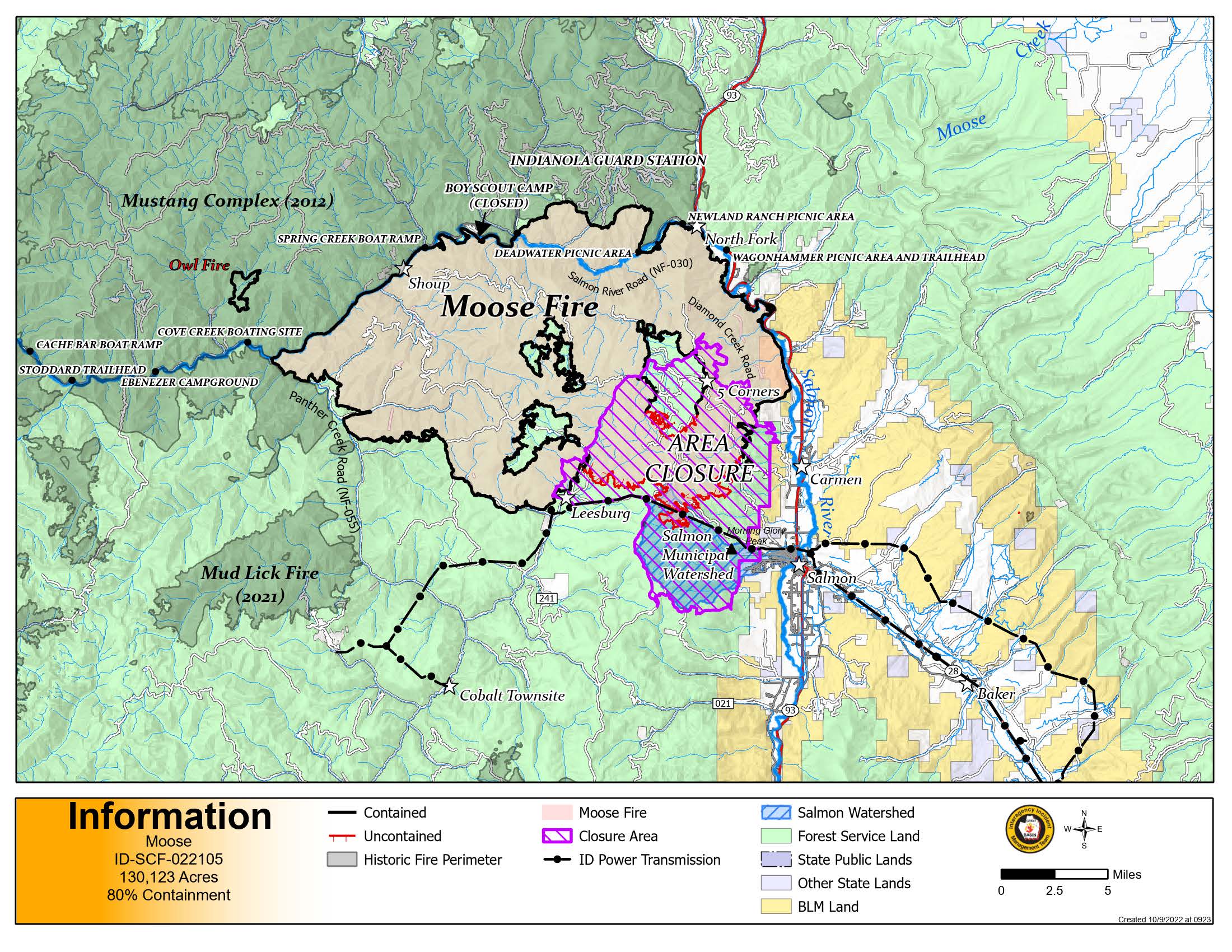
130,123 acres
Containment
80%
Start Date
7/17/22
Cause
Unextinguished unattended campfire
Incident Commander
Mike Johnston, Great Basin Type 2 Incident Management Team #7
Personnel
251
Online Links
InciWeb:
Facebook:
Idaho Department of Lands
Salmon-Challis National Forest
Bureau of Land Management Salmon Field Office
Summary: The Moose Fire started on Sunday, July 17th, 2022, at approximately 4:00 pm. The fire is located in the Salmon River mountains, 17 miles north of Salmon, Idaho. A mix of federal and private land is impacted. The terrain is difficult, and the fire is burning in grass, shrubs and timber. The fire was caused by an unextinguished, unattended campfire.
Weather | Anticipated Fire Behavior: A high pressure system continues. The weather today will be much like the last couple of days – warm and dry, with high overnight moisture recovery. By Monday afternoon winds will increase ahead of a cold front. Increased winds carry the potential of increased smoke production though fire behavior will remain moderate.
Actions: Repairs on the Leesburg Road and Ridge Road were completed today. Fire staff continue to repair areas impacted by fire suppression activities. Crews will be in the Moose Meadows area to remove pumps and hoses from around structures. Work along the Williams Creek Road and the Stormy Peak Road will continue today.
Ground truthing over the last couple of days has yielded repair statistics that are greater than were previously understood. Repair is 70% completed. Containment is currently at 80%.
Moose Fire Daily Update for Saturday October 8 2022
Related Incident:
Publication Type: News
Moose Fire Information 208-742-6690 (8am-8pm) | 2022.moose@firenet.gov
Quick Facts
Fire Location
17 miles N of Salmon, Idaho
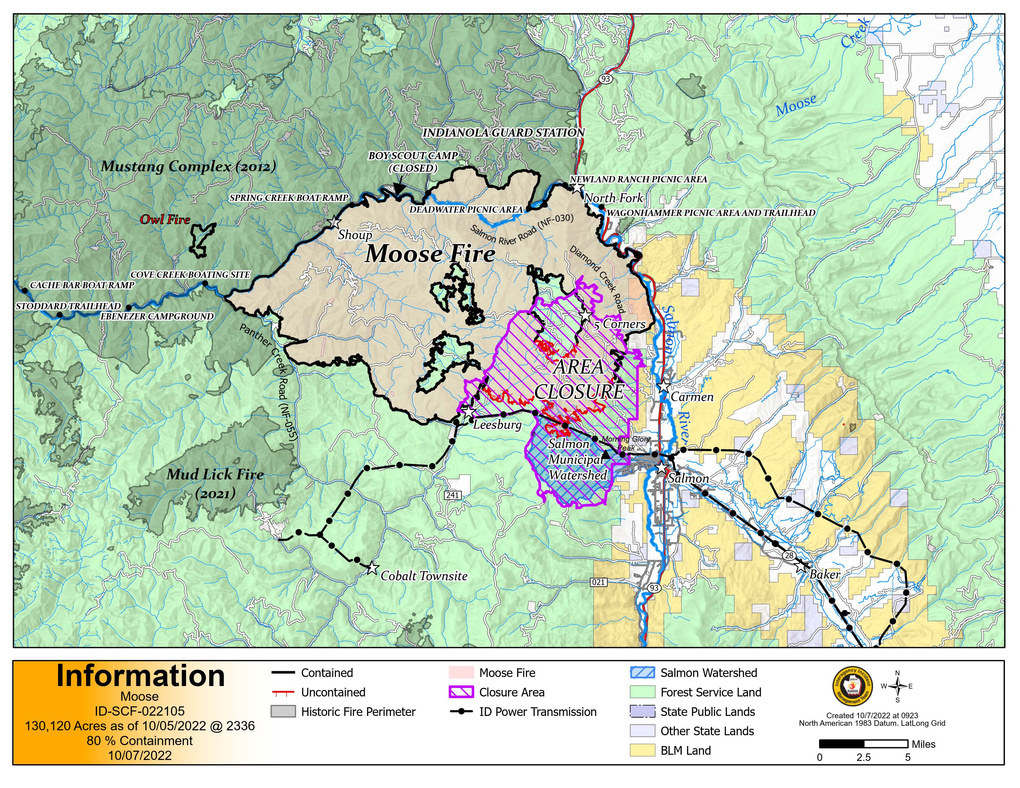
Size
130,120 acres
Containment
80%
Start Date
7/17/22
Cause
Unextinguished unattended campfire
Incident Commander
Mike Johnston, Great Basin Type 2 Incident Management Team #7
Personnel
261
Online Links
InciWeb:
· https://inciweb.nwcg.gov/incident/8249/
Facebook:
· https://www.facebook.com/IDFG.salmon
Idaho Department of Lands
· https://www.idl.idaho.gov/fire-management/
Salmon-Challis National Forest
· https://www.fs.usda.gov/scnf
Bureau of Land Management Salmon Field Office
· https://www.facebook.com/BLMIdahoFire
Summary: The Moose Fire started on Sunday, July 17th, 2022 at approximately 4:00 pm. The fire is located in the Salmon River mountains, 17 miles north of Salmon, Idaho. A mix of federal and private land is impacted. The terrain is difficult, and the fire is burning in grass, shrubs and timber. The fire was caused by an unextinguished unattended campfire.
Weather | Anticipated Fire Behavior: A high pressure system will continue to bring warm, dry weather through the weekend. High overnight moisture recovery is helping reduce fire activity. Temperatures have stayed warm and steady the past few days significantly increasing visible smoke. Lookouts are placed in strategic locations to keep watch on the fire, including in the watershed. Containment is currently at 80%.
Actions: Fire staff have completed 66% of previously identified repair points in and around the fire area. Today, the Ridge Road repair was finalized. Road repairs continue on the Old Leesburg Road south towards Spring Creek with the use of graders and water tenders. Hand crews are making progress removing excess debris from culverts. These efforts will reduce the likelihood of water damaging the road during rainstorms and snowmelt events.
Important Information: As of October 7, 2022 the Salmon-Challis National Forest reduced the Moose Fire closure area. The temporary closure of BLM lands which included the Morgan Bar campground has also been rescinded. Additional information and maps are available on the SCNF website at: https://www.fs.usda.gov/alerts/scnf/alerts-notices. Before venturing out to public lands near the Moose Fire, be aware that safety concerns still exist. To maintain the safety of the community and our fire personnel it’s important to stay out of the closure area. Though the danger from the fire has dissipated there are still numerous hazards that fire personnel are managing daily. These include operating around heavy equipment, steep terrain and possibility rolling debris.
Moose Fire Daily Update for Friday October 7
Related Incident:
Publication Type: News
Moose Fire Information 208-742-6690 (8am-8pm) | 2022.moose@firenet.gov
Quick Facts
Fire Location
17 miles N of Salmon, Idaho
Size
130,120 acres
Containment
80%
Start Date
7/17/22
Cause
Unextinguished unattended campfire
Incident Commander
Mike Johnston, Great Basin Type 2 Incident Management Team #7
Personnel
246
Online Links
InciWeb:
· https://inciweb.nwcg.gov/incident/8249/
Facebook:
· https://www.facebook.com/IDFG.salmon
Idaho Department of Lands
· https://www.idl.idaho.gov/fire-management/
Salmon-Challis National Forest
· https://www.fs.usda.gov/scnf
Bureau of Land Management Salmon Field Office
· https://www.facebook.com/BLMIdahoFire
Summary: The Moose Fire started on Sunday, July 17th, 2022 at approximately 4:00 pm. The fire is located in the Salmon River mountains, 17 miles north of Salmon, Idaho. A mix of federal and private land is impacted. The terrain is difficult, and the fire is burning in grass, shrubs and timber. The fire was caused by an unextinguished unattended campfire.
Weather | Anticipated Fire Behavior: A high pressure system will continue to bring warm, dry weather through the weekend. High overnight moisture recovery is helping reduce fire activity. An inversion is keeping lows near 50 degrees at 5,000-6,000 feet. The above average temperatures are expected to increase smoke in the coming days. Lookouts are placed in strategic locations to keep watch on the fire, including in the watershed. Containment is currently at 80%.
Actions: Resource advisors from the National Forest are working with fire crews to help protect natural resources and minimize the potential for future erosion. This work helps return damaged areas to a more stable condition. Resources are being shifted to focus on the uncontained portion of the fire. Yesterday, crews completed work in the Diamond Peak staging area. Road repairs using graders and water tenders are working on the Old Leesburg Road south towards Spring Creek. Hand crews are removing excess debris from culverts. Cleaning the culverts reduces the likelihood of water damaging the road during rainstorms and snowmelt events.
Important Information: The Salmon-Challis National Forest has reduced the Moose Fire closure area. Additional information and maps are available on the SCNF website at: https://www.fs.usda.gov/alerts/scnf/alerts-notices Before venturing out to public lands near the Moose Fire, be aware that safety concerns still exist. Watch out for fire weakened trees and limbs that can fall without warning. If wind picks up, leave the area immediately. In wet weather, water or mud may build up quickly and may cause a slide. Stump holes can remain hot long after the immediate danger has passed, and footing can be unstable if roots have burned out underground. Hot spots still exist within the fire perimeter.