
Forest Closure Order for September 19
Related Incident:
Publication Type: Closures
Number: 04-13-22-512
UNITED STATES DEPARTMENT OF AGRICULTURE FOREST SERVICE SALMON-CHALLIS NATIONAL FOREST NORTH FORK and SALMON COBALT RANGER DISTRICTS
Moose Fire Area, Road, and Trail Closure
PROHIBITIONS: Pursuant to 16 U.S.C. § 551 and 36 CFR 261.50 (a) and (b), the following acts are prohibited on the National Forest System (NFS) lands, roads, and trails on the North Fork and Salmon-Cobalt Ranger Districts of the Salmon-Challis National Forest described below and shown on the attached map incorporated into this Order as Exhibit A (the “Described Area” and “Described Roads and Trails”): 1.Going into or being upon the Described Area, 36 CFR 261.52(e). 2.Being on the Described Roads, 36 CFR 261.54(e). 3. Being on the Described Trails, 36 CFR 261.55(a).
EXEMPTIONS: Pursuant to 36 CFR 261.50(e), the following persons are exempt from this Order: 1.Persons with a special use authorization or other Forest Service authorization specifically exempting them from the effect of this Order; and 2.Any Federal, State, or local officer, or member of an organized rescue or fire fighting force in the performance of an official duty.
DESCRIBED AREA, ROADS, AND TRAILS:Described Area: All NFS lands on the North Fork and Salmon-Cobalt Ranger Districts of the Salmon-Challis National Forest in the area bounded at the junction of the Salmon-Challis National Forest boundary and National Forest System Road (NFSR) #021 Williams Creek Road, then following NFSR #021 Williams Creek Road to NFSR #101 Deep Creek Road, then following NFSR #101 Deep Creek Road to NFSR #055 Morgan/Panther Creek Road, then following NFSR #055 Morgan/Panther Creek Road to NFSR #057 Beaver Creek Road to its intersection with Wagon Road Gulch, then following Wagon Road Gulch northeast to its intersection with NFSR #032 Pine Creek Road, the following NFSR #032 Pine Creek Road to its junction with National Forest System Trail (NFST) #6175 Virginia Gulch Trail, then following NFST #6175 to where it iOrder Number: 04-13-22-512
UNITED STATES DEPARTMENT OF AGRICULTURE FOREST SERVICE
SALMON-CHALLIS NATIONAL FOREST
NORTH FORK and SALMON COBALT RANGER DISTRICTS Moose Fire Area, Road, and Trail Closure
PROHIBITIONS:
Pursuant to 16 U.S.C. § 551 and 36 CFR 261.50 (a) and (b), the following acts are prohibited on the National Forest System (NFS) lands, roads, and trails on the North Fork and Salmon-Cobalt Ranger Districts of the Salmon-Challis National Forest described below and shown on the attached map incorporated into this Order as Exhibit A (the “Described Area” and “Described Roads and Trails”):
1. 2. 3.
Going into or being upon the Described Area, 36 CFR 261.52(e). Being on the Described Roads, 36 CFR 261.54(e).
Being on the Described Trails, 36 CFR 261.55(a).
EXEMPTIONS:
Pursuant to 36 CFR 261.50(e), the following persons are exempt from this Order:
-
Persons with a special use authorization or other Forest Service authorization specifically
exempting them from the effect of this Order; and
-
Any Federal, State, or local officer, or member of an organized rescue or fire fighting force in
the performance of an official duty.
DESCRIBED AREA, ROADS, AND TRAILS:
Described Area: All NFS lands on the North Fork and Salmon-Cobalt Ranger Districts of the Salmon- Challis National Forest in the area bounded at the junction of the Salmon-Challis National Forest boundary and National Forest System Road (NFSR) #021 Williams Creek Road, then following NFSR #021 Williams Creek Road to NFSR #101 Deep Creek Road, then following NFSR #101 Deep Creek Road to NFSR #055 Morgan/Panther Creek Road, then following NFSR #055 Morgan/Panther Creek Road to NFSR #057 Beaver Creek Road to its intersection with Wagon Road Gulch, then following Wagon Road Gulch northeast to its intersection with NFSR #032 Pine Creek Road, the following NFSR #032 Pine Creek Road to its junction with National Forest System Trail (NFST) #6175 Virginia Gulch Trail, then following NFST #6175 to where it intersects the boundary between the North Fork Ranger District and the Salmon-Cobalt Ranger District, the following the North Fork Ranger District and Salmon-Cobalt Ranger District Boundary east to its intersection with NFSR #020 Ridge Road, then following NFSR #020 Ridge Road to its intersection with NFSR #129 Diamond Creek Road, then following NFSR #129 Diamond Creek Road to its intersection with Bird Creek, then following Bird Creek east to its junction with the Salmon-Challis National Forest Boundary, then following the Salmon- Challis National Forest Boundary south to the point of origin at the junction of the Salmon-Challis National Forest boundary and NFSR #021 Williams Creek Road.
Described Roads and Trails: All NFS roads (NFSR) and trails (NFST) within the Closed Area are closed, except as noted below.
Note: The main Salmon River is open. River access and recreation sites along NFSR #030 Salmon River Road are also open.
The following National Forest System Roads (NFSR) and Trails (NFST) are open:
-
NFSR #030 Salmon River Road
-
NFSR #055 Morgan/Panther Creek Road
-
NFSR #021 Williams Creek Road
-
NFSR #101 Deep Creek Road
-
NFST #6175 Virginia Gulch Trail
PURPOSE:
The purpose of this Order is to protect public health and safety from the effects of the Moose Fire.
IMPLEMENTATION:
-
This Order will be in effect from September 19, 2022 and shall remain in effect until rescinded.
-
A map identifying the Closed Area is attached and made part of this Order.
-
Any violation of the prohibition in this Order is punishable by a fine of not more than $5,000
for individuals, and $10,000 for organizations,
imprisonment for not more than six months, or both. [16 U.S.C. § 551, 18 U.S.C. §§ 3559, 3571, 3581]. -
This Order supersedes any previous orders prohibiting the same acts covered by this Order.
Executed in Salmon, Idaho, this 19th day of September 2022 ___________________________ CHARLES MARK
Forest Supervisor
Salmon-Challis National ForestDistrict and the Salmon-Cobalt Ranger District, th
Evacuation Status Update for Monday September 19
Related Incident:
Publication Type: Announcement
Lemhi County updated Moose Fire evacuation status this morning, Monday, September 19
Zones 11, 12 ,and 13 will be moved to "READY" status.
Zone 11 is fairgrounds to Moore Creek Road (west side of Highway)
Zone 12 is Upper Fairmont to Hayhook Drive
Zone 13 is 16th Street to Pollard Creek including Leesburg and Black Rock.
Zone 1- Fairgrounds to Tower Creek on the west side of the river will remain in "SET" status
Moose and Owl Fire Daily Update for Monday September 19
Related Incident:
Publication Type: News
Moose and Owl Fire Daily Update September 18, 2022
Fire Information: 208-742-6690 daily from 8 AM – 8 PM Email: 2022.moose@firenet.gov
Salmon-Challis National Forest Facebook: https://www.facebook.com/salmonchallisnf
Inciweb: https://inciweb.nwcg.gov/incident/8249/
INCIDENT STATISTICS
Moose Fire: 130,092 Acres, 51% Containment , 787 Personnel
Owl Fire: 747 Acres, 53% Containment, 40 Personnel
COMMUNITY MEETING: Join us for an in-person meeting on Monday, September 19, 2022, at 6:00 pm at the Idaho Fish and Game, Salmon Regional Office – 99 Highway 93 North Salmon, ID.
Firefighting crews along Stormy Peak Road will be working both direct (right up against the fire line) and indirect (further away from the fire’s edge) on spot fires located by drones. Where the terrain allows, hand crews working along Old Leesburg Road will address areas of heat. Heavy equipment is being used to reduce fuels on the Ridge Line Road (NFSR 020) as a contingency line. Crews are in Turner Gulch to slow or moderate fire progression in the municipal watershed. This operation, along with heavy equipment operators working along the powerline, is intended to halt any potential southward progression of the fire.
Hand crews and operators completed chipping operations along Williams Creek Road. These crews will begin chipping on Ridge Line Road and begin rehabilitation work. Heavy equipment operators will be utilizing feller bunchers along Ridge Line Road to eliminate hazardous trees and provide safe conditions for hand crews.
Yesterday crews on the Owl fire identified minimal heat or movement. The increase in containment on the Owl fire is primarily on the west flank. Today they will fly drones on the east flank and send a hotshot crew if needed to take care of any remaining spots of heat.
EVACUATIONS: Zones 1, 11, 12, and 13, the Beartrack Mine, and Leesburg remain in "SET" status. The Incident Management Team will continue to work closely with the Sheriff’s Office to consider changes to the evacuation status over the next few days, depending on the weather. Additional details are at: https://bit.ly/LemhiCountyEvacs
CLOSURES AND RESTRICTIONS: A Salmon-Challis National Forest closure order was updated on September 9. The closure includes the area north of Williams Creek Road (FR-021), Deep Creek Road (FR-101), and certain roads, trails, and a defined geographic area around the fire. Moose Fire Emergency Area, Road, and Trail Closure, Order #04-13-22-509. This closure applies to hunting access, firewood cutting and gathering, fishing, hiking, camping, and other recreational activities·
Public Lands north of the town of Salmon, south of Wallace Creek, and west of the Salmon River administered by the Salmon Field Office, Bureau of Land Management (BLM) are temporarily closed.·
Stage 1 Fire restrictions are in effect on the Salmon-Challis National Forest, BLM, and State of Idaho lands in Custer and Lemhi Counties, excluding wilderness areas.·
For more information about area hunting units, please visit the Idaho Fish and Game fire map: https://fishandgame.idaho.gov/ifwis/maps/realtime/fire/ or the Idaho Fish and Game Salmon Region Facebook page https://www.facebook.com/IDFG.salmon.
Visit our website at: https://www.fs.usda.gov/scnf, “Like Us” on Facebook @salmonchallisnf, and “Follow Us” on Twitter @salmonchallisnf https://twitter.com/SalmonChallisNF
COMMUNITY MEETING Monday September 19
Related Incident:
Publication Type: Announcement
COMMUNITY MEETING: Join us for an in-person meeting on Monday, September 19, 2022, at 6:00 pm at the Idaho Fish and Game, Salmon Regional Office – 99 Highway 93 North Salmon, ID.
Moose and Owl Fires Daily Update for Sunday September 18
Related Incident:
Publication Type: News
Moose and Owl Fire Daily Update September 18, 2022
Fire Information: 208-742-6690 daily from 8 AM – 8 PM Email: 2022.moose@firenet.gov
Salmon-Challis National Forest Facebook: https://www.facebook.com/salmonchallisnf
Inciweb: https://inciweb.nwcg.gov/incident/8249/
INCIDENT STATISTICS
Moose Fire, 130,092 Acres, 51% Containment, 787 Personnel
Owl Fire, 747 Acres, 53% Containment, 40 Personnel
COMMUNITY MEETING: Join us for an in-person meeting on Monday, September 19, 2022, at 6:00 pm at the Idaho Fish and Game, Salmon Regional Office – 99 Highway 93 North Salmon, ID.
Firefighting crews along Stormy Peak Road will be working both direct (right up against the fire line) and indirect (further away from the fire’s edge) on spot fires located by drones. Where the terrain allows, hand crews working along Old Leesburg Road will address areas of heat. Heavy equipment is being used to reduce fuels on the Ridge Line Road (NFSR 020) as a contingency line. Crews are in Turner Gulch to slow or moderate fire progression in the municipal watershed. This operation, along with heavy equipment operators working along the powerline, is intended to halt any potential southward progression of the fire.
Hand crews and operators completed chipping operations along Williams Creek Road. These crews will begin chipping on Ridge Line Road and begin rehabilitation work. Heavy equipment operators will be utilizing feller bunchers along Ridge Line Road to eliminate hazardous trees and provide safe conditions for hand crews.
Yesterday crews on the Owl fire identified minimal heat or movement. The increase in containment on the Owl fire is primarily on the west flank. Today they will fly drones on the east flank and send a hotshot crew if needed to take care of any remaining spots of heat.
EVACUATIONS: Zones 1, 11, 12, and 13, the Beartrack Mine, and Leesburg remain in "SET" status. The Incident Management Team will continue to work closely with the Sheriff’s Office to consider changes to the evacuation status over the next few days, depending on the weather. Additional details are at: https://bit.ly/LemhiCountyEvacs
CLOSURES AND RESTRICTIONS: A Salmon-Challis National Forest closure order was updated on September 9. The closure includes the area north of Williams Creek Road (FR-021), Deep Creek Road (FR-101), and certain roads, trails, and a defined geographic area around the fire. Moose Fire Emergency Area, Road, and Trail Closure, Order #04-13-22-509. This closure applies to hunting access, firewood cutting and gathering, fishing, hiking, camping, and other recreational activities·
-Public Lands north of the town of Salmon, south of Wallace Creek, and west of the Salmon River administered by the Salmon Field Office, Bureau of Land Management (BLM) are temporarily Closed.·
- Stage 1 Fire restrictions are in effect on the Salmon-Challis National Forest, BLM, and State of Idaho lands in Custer and Lemhi Counties, excluding wilderness areas.·
-For more information about area hunting units, please visit the Idaho Fish and Game fire map: https://fishandgame.idaho.gov/ifwis/maps/realtime/fire/ or the Idaho Fish and Game Salmon Region Facebook page https://www.facebook.com/IDFG.salmon.
Visit our website at: https://www.fs.usda.gov/scnf, “Like Us” on Facebook @salmonchallisnf, and “Follow Us” on Twitter @salmonchallisnf https://twitter.com/SalmonChallisNF
Moose and Owl Fire Daily Update for Saturday September 17
Related Incident:
Publication Type: News
Moose and Owl Fire Daily Update September 17, 2022
Fire Information: 208-742-6690 daily from 8 AM – 8 PM Email: 2022.moose@firenet.gov Salmon-Challis National Forest Facebook: https://www.facebook.com/salmonchallisnf
Inciweb: https://inciweb.nwcg.gov/incident/8249/
INCIDENT STATISTICS
Acres Containment Personnel
Moose Fire 130,086 50% 838
Owl Fire 747 0 % 72
COMMUNITY MEETING: Join us for an in-person meeting on Monday, September 19, 2022, at 6:00 pm at the Idaho Fish and Game, Salmon Regional Office – 99 Highway 93 North Salmon, ID.
Last night we experienced minimal fire movement along the perimeter, however drones and hand crews are still finding and controlling spots of heat. As crews work in these areas, they are being mindful of fire-weakened snags that may fall due to the predicted gusty winds. Heavy equipment operators will be utilizing feller bunchers along Ridge Road to eliminate these snag hazards.
With the assistance of local resource advisors, fire managers began preparations for repair operations. Hand crews began rehab along the Diamond Line and drone flights will continue to monitor the area for hotspots. Firefighters are nearing completion of the contingency containment lines along Williams Creek Road. Structure protection, patrolling, and mop- up operations will continue in the Leesburg area and along the powerline where crews can safely work. Defensive water systems placed around the Leesburg Mine area provide an extra measure of security.
Hotshot crews working on the Owl Fire will be looking for direct attack locations to reduce growth. Additionally, engine crews and structure protection firefighters continue to protect threatened buildings in the area.
EVACUATIONS: Zones 1, 11, 12, and 13, the Beartrack Mine, and Leesburg remain in "SET" status in the CodeRED system as determined by the Lemhi County Sheriff’s Office. The Incident Management Team will continue to work closely with the Sheriff’s Office to consider changes to the evacuation status over the next few days, depending on the weather. Additional details are at: https://bit.ly/LemhiCountyEvacs
CLOSURES AND RESTRICTIONS: A Salmon-Challis National Forest closure order was updated on September 9. The closure includes the area north of Williams Creek Road (FR-021), Deep Creek Road (FR-101), and certain roads, trails, and a defined geographic area around the fire. Moose Fire Emergency Area, Road, and Trail Closure, Order #04-13-22-509. This closure applies to hunting access, firewood cutting and gathering, fishing, hiking, camping, and other recreational activities
•
• Stage 1 Fire restrictions are in effect on the Salmon-Challis National Forest, BLM, and State of Idaho lands in
Custer and Lemhi Counties, excluding wilderness areas.
•
Visit our website at: https://www.fs.usda.gov/scnf, “Like Us” on Facebook @salmonchallisnf, and “Follow Us” on Twitter @salmonchallisnf https://twitter.com/SalmonChallisNF
Public Lands north of the town of Salmon, south of Wallace Creek, and west of the Salmon River administered by
the Salmon Field Office, Bureau of Land Management (BLM) are temporarily Closed.
For more information about area hunting units, please visit the Idaho Fish and Game fire map:
https://fishandgame.idaho.gov/ifwis/maps/realtime/fire/ or the Idaho Fish and Game Salmon Region Facebook
page https://www.facebook.com/IDFG.salmon.
Final Cerro Pelado Burned Area Closure Terminated
Related Incident: Cerro Pelado
Publication Type: News
Final Cerro Pelado Burned Area Closure Terminated
NM Highway 4 Recreation Sites Now Open
USDA is an equal opportunity provider, employer and lender.
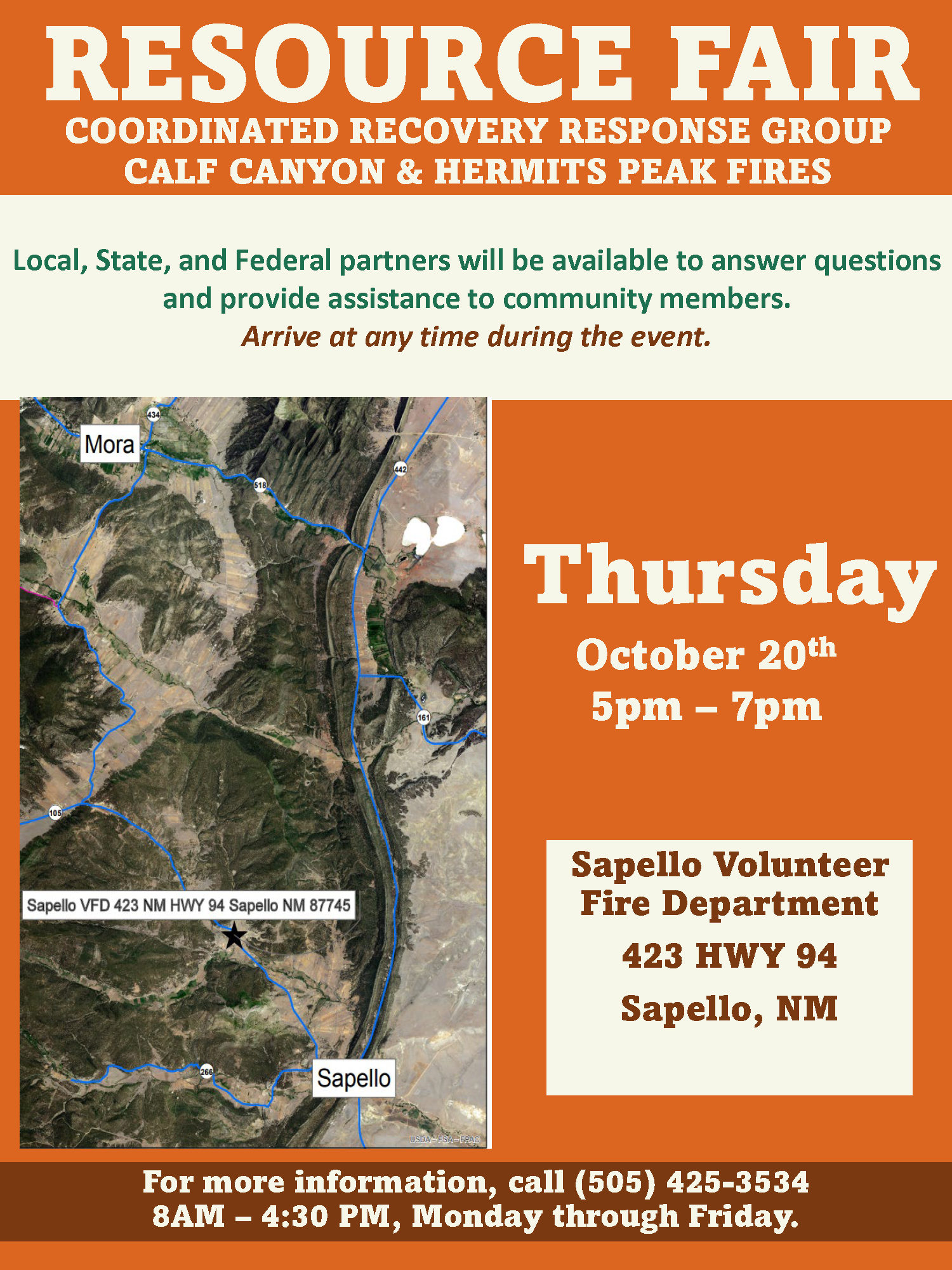
October 20th Resource Fair at Sapello VFD
Related Incident: Calf Canyon
Publication Type: Announcement
Local, State, and Federal partners will be available to answer questions and provide assistance to community members.
Arrive at any time during the event.
Sapello Volunteer Fire Department
For step-by-step directions enter the following address into Google Maps:
423 HWY 94 SAPELLO, NM 87745
Thursday, October 20th, 2022 from 5pm – 7pm
Suppression repair request phone line to be discontinued Sun 100922
Related Incident: Calf Canyon
Publication Type: Announcement
The Calf Canyon – Hermits Peak Fires ‘Suppression Repair Request’ phone line will be discontinued on Sunday, October 9, 2022. This phone line is for private property owners whose land sustained damage (i.e., dozer line, crushed culvert, fence damage, etc.) during the firefighting efforts.
If you have damage on your property and would like to request a repair, please contact your nearest Forest Service District Office.
Santa Fe National Forest - Pecos Ranger District: (505) 757-6121
Santa Fe National Forest - Las Vegas Ranger District: (505) 425-3534
Carson National Forest - Camino Real Ranger Station: (575) 587-2255

Resource Fair Announcement September 29 2022
Related Incident: Calf Canyon
Publication Type: Announcement
Local, State, and Federal partners will be available to answer questions and provide assistance to community members. Arrive at any time during the event.
Cabo Lucero Volunteer Fire Department
For step by step directions enter the following address into Google Maps.
21 COUNTY RD A29 LAS VEGAS, NM 87701
Thursday, September 29, 2022 5pm – 7pm Mineral Hill Community