
Community Coordinated Response Agency Resources
Related Incident: Calf Canyon
Publication Type: Announcement
A list of partners helping with Community Coordinated Response is now available. The document (available below) contains a brief description of what each organization does and how they can help, contact information, and links to their webpage.
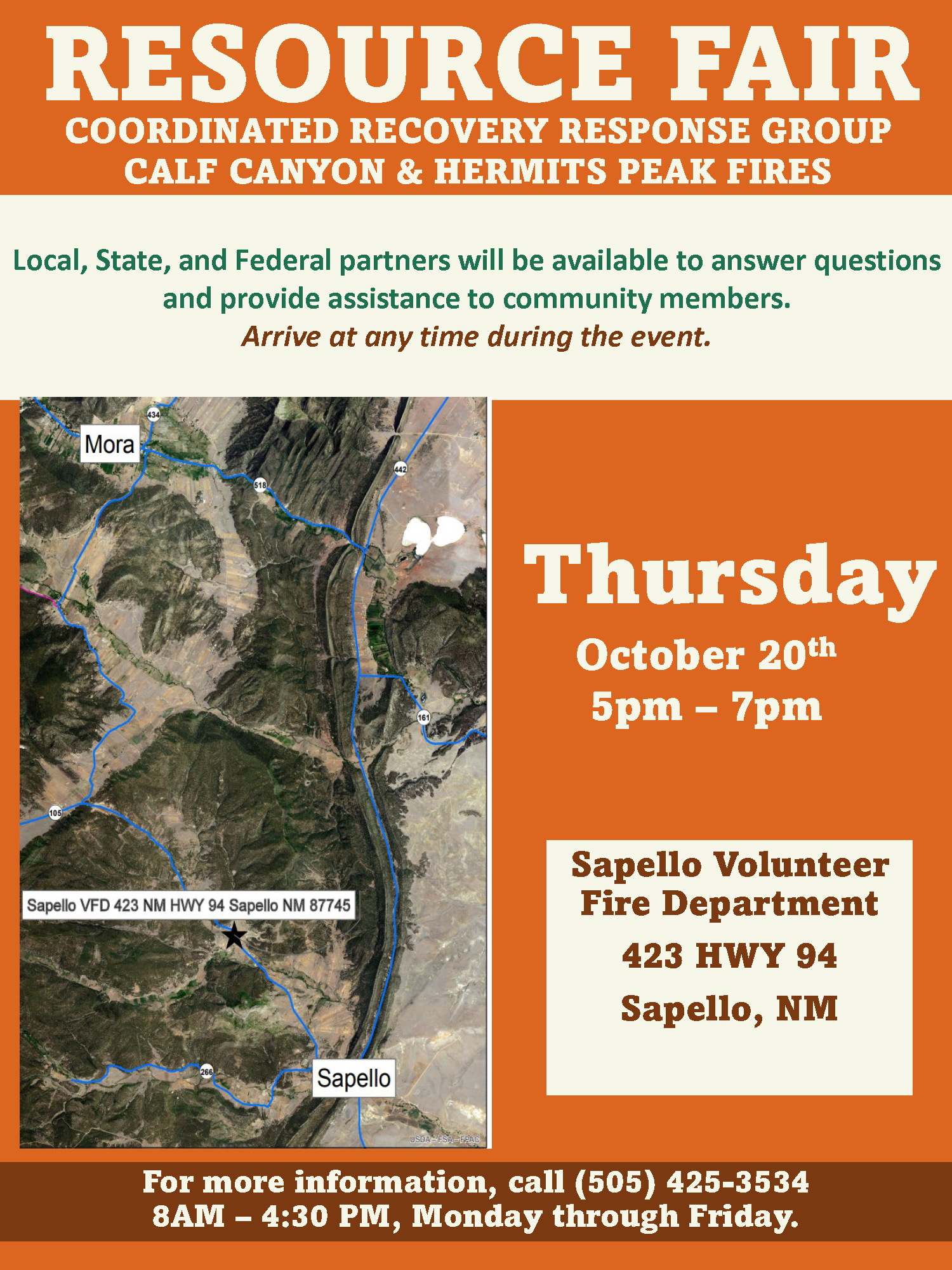
October 20th Resource Fair Sapello VFD
Related Incident: Hermits Peak Fire
Publication Type: Announcement
Local, State, and Federal partners will be available to answer questions and provide assistance to community members.
Arrive at any time during the event.
Sapello Volunteer Fire Department
For step-by-step directions enter the following address into Google Maps:
423 HWY 94 SAPELLO, NM 87745
Thursday, October 20th, 2022 from 5pm – 7pm
Suppression repair request phone line to be discontinued Sun 100922
Related Incident: Hermits Peak Fire
Publication Type: Announcement
The Calf Canyon – Hermits Peak Fires ‘Suppression Repair Request’ phone line will be discontinued on Sunday, October 9, 2022. This phone line is for private property owners whose land sustained damage (i.e., dozer line, crushed culvert, fence damage, etc.) during the firefighting efforts.
If you have damage on your property and would like to request a repair, please contact your nearest Forest Service District Office.
Santa Fe National Forest - Pecos Ranger District: (505) 757-6121
Santa Fe National Forest - Las Vegas Ranger District: (505) 425-3534
Carson National Forest - Camino Real Ranger Station: (575) 587-2255
Resource Fair Announcement September 29 2022
Related Incident: Hermits Peak Fire
Publication Type: Announcement
Local, State, and Federal partners will be availablto answer questions and provide assistance to community members.
Arrive at any time during the event.
Cabo Lucero Volunteer Fire Department
For step by step directions enter the following address into Google Maps.
21 COUNTY RD A29 LAS VEGAS, NM 87701
Thursday, September 29, 2022 5pm – 7pm Mineral Hill Community
Community Coordinated Response Agency Resources
Related Incident: Hermits Peak Fire
Publication Type: News
A list of partners helping with Community Coordinated Response is now available. The document (available below) contains a brief description of what each organization does and how they can help, contact information, and links to their webpage.
North Powderhorn Fuels Project Public Meeting Oct 18 2022 5PM
Related Incident:
Publication Type: Announcement
North Powderhorn Fuels Project Environmental Assessment (EA)
Gunnison Field Office invites the public to attend the North Powderhorn Fuels Project Environmental Assessment meeting to learn more about the project. Purpose of the proposed action is to reduce the likelihood of high-severity fire, reduce soil degradation from high-severity surface fires and other types of surface disturbance increase heterogeneity across the project area; reduce stand density; promote regeneration and species diversity to reduce the effects and frequency of insect and disease outbreaks. These actions would improve the mosaic of vegetation and the overall ecological conditions throughout the project area, which would in turn improve their resistance and resilience to future disturbances like fire, insect outbreaks, drought, and other impacts related to climate change. This is especially critical for wilderness. Within the project area, such outcomes would serve to restore, retain, enhance, and protect both wilderness character and resource values in the Powderhorn Wilderness. Improvement of ecological function would directly benefit the natural character of the wilderness and would create attendant benefits for high-quality solitude and opportunities for primitive recreation in the wilderness.
Open House & Virtual Public Meeting
Tuesday, October 18, 2022, 5:00 PM to 8:00 PM
Public Meeting Location: Western Colorado University Ballroom, University Center 102, 1 Western Way, Gunnison, CO 81230
Virtual Meeting Option:
Zoom Registration: https://empsi.zoom.us/webinar/register/WN_XOQx8NGmTdqgfMeVkXek6A
Project information and documents are posted on the BLM ePlanning project website [DOI-BLM-CO-S060-2022-0018-EA] at https://eplanning.blm.gov/eplanning-ui/project/2021619/510.
Exceptional day at Dawson Prescribed Burn Oct 15 2022
Related Incident:
Publication Type: News
Today proved to be an exceptional day at Dawson prescribed burn on Tres Rios Field Office BLM managed lands. Firefighters were able to finish the last unit for a total of 885 acres accomplished in the past three days. The units will be patrolled.
Smoke might be visible on parts of Highway 141 and could settle in the Disappointment Valley overnight. While smoke may be visible in the burn area at times, most of the smoke will lift and dissipate during the warmest parts of the day. Expect visible smoke in the area for several days as vegetation in the interior continues to smolder.
The BLM obtained smoke permits from the Colorado State Air Pollution Control Division, which identify atmospheric conditions under which the burns can be implemented. Prescribed fire smoke may affect your health. For more information, visit https://www.colorado.gov/pacific/cdphe/wood-smoke-and-health.
For information on prescribed burns, visit the Southwest District BLM Prescribed Fire InciWeb page https://inciweb.nwcg.gov/incident/7852/ and follow us on Twitter https://twitter.com/SWD_Fire and Facebook http://www.facebook.com/BLMMontroseFireUnit.
Dawson Prescribed Burn Continues Oct 15 2022
Related Incident:
Publication Type: News
BLM Tres Rios Field Office Oct. 15, 2022 – Yesterday, firefighters on Dawson Prescribed Burn had another great day of burning. They accomplish 200 acres, bringing the total to 480 acres accomplished in the last two days. If conditions allow, firefighters will continue to burn the remaining unit today. Project area is located 11.5 miles east of Egnar, Colorado.
This prescribed burn will assist in reducing mechanical treated pinyon and juniper debris and increase grass and forb production for big game and grazing by reducing the oak and sagebrush.
Smoke might be visible on parts of Highway 141 and could settle in the Disappointment Valley overnight. While smoke may be visible in the burn area at times, most of the smoke will lift and dissipate during the warmest parts of the day. Expect visible smoke in the area for several days after each burn is completed as vegetation in the interior continues to smolder.
The BLM obtained smoke permits from the Colorado State Air Pollution Control Division, which identify atmospheric conditions under which the burns can be implemented. Prescribed fire smoke may affect your health. For more information, visit https://www.colorado.gov/pacific/cdphe/wood-smoke-and-health.
For information on prescribed burns, visit the Southwest District BLM Prescribed Fire InciWeb page https://inciweb.nwcg.gov/incident/7852/ and follow us on Twitter https://twitter.com/SWD_Fire and Facebook http://www.facebook.com/BLMMontroseFireUnit.
Dawson Prescribed Burn plans to continue Oct 14 15 2022
Related Incident:
Publication Type: News
BLM Tres Rios Field Office Oct. 14, 2022 - Great weather conditions yesterday made it possible for firefighters to treat 280 acres on the Dawson Prescribed Burn project. If conditions allow, firefighters will continue to burn the remaining 700 acres today and tomorrow. Project area is located 11.5 miles east of Egnar, Colorado.
This prescribed burn will assist in reducing mechanical treated pinyon and juniper debris and increase grass and forb production for big game and grazing by reducing the oak and sagebrush.
Smoke might be visible on parts of Highway 141 and could settle in the Disappointment Valley overnight. While smoke may be visible in the burn area at times, most of the smoke will lift and dissipate during the warmest parts of the day. Expect visible smoke in the area for several days after each burn is completed as vegetation in the interior continues to smolder.
The BLM obtained smoke permits from the Colorado State Air Pollution Control Division, which identify atmospheric conditions under which the burns can be implemented. Prescribed fire smoke may affect your health. For more information, visit https://www.colorado.gov/pacific/cdphe/wood-smoke-and-health.
For information on prescribed burns, visit the Southwest District BLM Prescribed Fire InciWeb page https://inciweb.nwcg.gov/incident/7852/ and follow us on Twitter https://twitter.com/SWD_Fire and Facebook http://www.facebook.com/BLMMontroseFireUnit.
Dawson Prescribed Burn Planned Oct 13 15 2022
Related Incident:
Publication Type: News
BLM Tres Rios Field Office plans to prescribed burn at Dawson Project area. If conditions allow, they will burn three units for 980 acres of BLM land located 11.5 miles east of Egnar, Colorado on October 13 - 16. Prescribed burn will assist in reducing mechanical treated pinyon and juniper debris and increase grass and forb production for big game and grazing by reducing the oak and sagebrush.
Smoke might be visible on parts of Highway 141 and could settle in the Disappointment Valley overnight. While smoke may be visible in the burn area at times, most of the smoke will lift and dissipate during the warmest parts of the day. Expect visible smoke in the area for several days after each burn is completed as vegetation in the interior continues to smolder.
The BLM obtained smoke permits from the Colorado State Air Pollution Control Division, which identify atmospheric conditions under which the burns can be implemented. Prescribed fire smoke may affect your health. For more information, visit https://www.colorado.gov/pacific/cdphe/wood-smoke-and-health.
For information on prescribed burns, visit the Southwest District BLM Prescribed Fire InciWeb page https://inciweb.nwcg.gov/incident/7852/ and follow us on Twitter https://twitter.com/SWD_Fire and Facebook http://www.facebook.com/BLMMontroseFireUnit.