
Moose Fire Public Meeting for September 26
Related Incident:
Publication Type: Announcement
Moose Fire Community Fire Information Meeting (In-Person)
6 p.m. (MT)September 26, 2022Idaho Fish and Game Office99 Highway 93 North Salmon, Idaho
If you cannot attend and would like to submit a question ahead of time, please email 2022.moose@firenet.gov by noon on Monday.

Moose Fire Public Meeting for September 22
Related Incident:
Publication Type: Announcement
We would love to see you in person for a Moose Fire community Thursday evening, September 22 at the Forest Supervisor's office, 1206 S. Challis St In Salmon.
Note: This meeting will not be on Facebook Live but it will be recorded and posted online afterwards both here on the Salmon-Challis National Forest Facebook page and on YouTube www.youtube.com/channel/UCRTjI3ZoZDOmORid09GEodg
Moose Fire Daily Update for Sunday September 25
Related Incident:
Publication Type: News
Moose Fire Daily Update for September 25, 2022
Tomorrow, Monday, September 26th, we will be hosting a community meeting at the Idaho Fish & Game Office. Start time will be 6:00 p.m. for those who wish to attend. The meeting will be filmed and posted to the Salmon-Challis National Forest Facebook page for those who prefer to watch at home. If you cannot attend and have a question to submit for the meeting, please email 2022.moose@firenet.gov by noon on Monday.
Yesterday, crews continued work on suppressing hot spots and suppression repair on the fire. Firefighters patrolled the roadway along the Salmon River on the northwest flank of the burn area without any findings and neared completion of their road improvement work in that division. Suppression repair work is ready to begin near Wagonhammer and Tower Creek. Resource Advisors (READs) will be coordinating with private landowners in the area.
Dry weather, moderate temperatures, and light winds should have a continued moderating effect on fire growth. Minimal, smoldering fire behavior should allow for crews working in the active edges of the fire to continue their efforts with the suppression of hot spots on southeast flank of the fire. The Wildland Fire Module has completed its suppression work where it was safe to do so in the municipal watershed and is now working on backhaul and assisting with suppression repair. They will continue to observe and take appropriate actions as they are able.
Log and slash removal work progresses in the powerline corridor. A temporary power outage can be expected in the coming days. Idaho Power is in close communication with incident management and will alert effected customers.
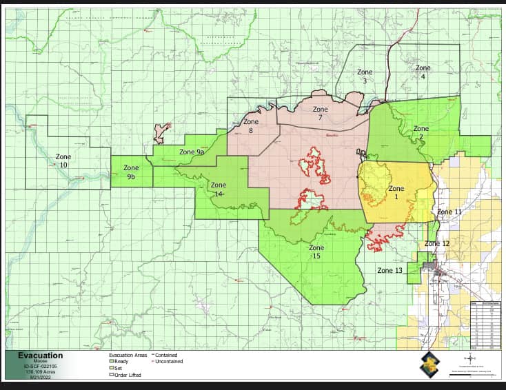
EVACUATIONS: Zone 1 remains in “SET” status today, while Zones 11, 12, and 13 are stable in “READY” status. Beartrack Mine and Leesburg also remain in “READY” status at this time. As a reminder, the evacuation status has been rescinded for Zones 3, 4, 7, 8, and 10. The Incident Management Team will continue to work closely with the Sheriff’s Office to consider changes to the evacuation status. Additional details are at: https://bit.ly/LemhiCountyEvacs
CLOSURES AND RESTRICTIONS: A Salmon-Challis National Forest closure order was updated on September 19. It reduces the closure area lands north of Williams Creek and Deep Creek Roads, east of Panther Creek Road, and south of North Fork Ranger District/Salmon-Cobalt Ranger District. The closure includes national forest service lands pertaining to certain roads, trails, and a defined geographic area around the fire. See Moose Fire Emergency Area, Road, and Trail Closure, Order #04-13-22-512 for complete description. This closure applies to hunting access, firewood cutting and gathering, fishing, hiking, camping, and other recreational activities. - Public Lands north of the town of Salmon, south of Wallace Creek, and west of the Salmon River administered by the Salmon Field Office, Bureau of Land Management (BLM) are temporarily Closed. - Stage 1 Fire restrictions are in effect on the Salmon-Challis National Forest, BLM, and State of Idaho lands in Custer and Lemhi Counties, excluding wilderness areas. - For more information about area hunting units, please visit the Idaho Fish and Game fire map: https://fishandgame.idaho.gov/ifwis/maps/realtime/fire/ or the Idaho Fish and Game Salmon Region Facebook page https://www.facebook.com/IDFG.salmon.
Moose Fire Daily Update for Saturday September 24
Related Incident:
Publication Type: News
Moose Fire Daily Update for September 24, 2022
This morning a procession will take fallen firefighter Gerardo Rincon to the airport to be flown home. Gerardo succumbed to a medical emergency while fighting the Moose Fire on September 20th. Our hearts go out to his family, friends, and colleagues, as he makes this final journey.
On the fire yesterday, crews were able to grade Diamond Road toward 5 Corners. Firefighters also began assessing possibilities for going direct south of Jackass Ridge to add more containment around that interior edge of the fire.
Today, relative humidity will continue to fall as drier weather moves into the area. However, lower wind speeds and moderate temperatures are expected to keep fire behavior limited to creeping and smoldering over the weekend.
A Wildland Fire Module will continue finding and suppressing hot spots in the Salmon Municipal Watershed. Firefighters are also scouting north of the powerline for opportunities to go direct. Slash removal around the powerline corridor is ongoing and may result in a temporary power outage in the coming days, ideally for less than one day. Idaho Power is in close communication with incident management and will alert customers before this plan goes into effect. Trucks are also hauling logs from the powerline fuel break.
Suppression repair efforts are underway throughout the burned area, where conditions allow. Where they are able, crews are backhauling equipment and are working to further secure Beartrack Mine and Leesburg.
EVACUATIONS: Zone 1 remains in “SET” status today, while Zones 11, 12, and 13 are stable in “READY” status. Beartrack Mine and Leesburg also remain in “READY” status at this time. As a reminder, the evacuation status has been rescinded for Zones 3, 4, 7, 8, and 10. The Incident Management Team will continue to work closely with the Sheriff’s Office to consider changes to the evacuation status. Additional details are at: https://bit.ly/LemhiCountyEvacs
CLOSURES AND RESTRICTIONS: A Salmon-Challis National Forest closure order was updated on September 19. It reduces the closure area lands north of Williams Creek and Deep Creek Roads, east of Panther Creek Road, and south of North Fork Ranger District/Salmon-Cobalt Ranger District. The closure includes national forest service lands pertaining to certain roads, trails, and a defined geographic area around the fire. See Moose Fire Emergency Area, Road, and Trail Closure, Order #04-13-22-512 for complete description. This closure applies to hunting access, firewood cutting and gathering, fishing, hiking, camping, and other recreational activities.
- Public Lands north of the town of Salmon, south of Wallace Creek, and west of the Salmon River administered by the Salmon Field Office, Bureau of Land Management (BLM) are temporarily Closed.
- Stage 1 Fire restrictions are in effect on the Salmon-Challis National Forest, BLM, and State of Idaho lands in Custer and Lemhi Counties, excluding wilderness areas.
- For more information about area hunting units, please visit the Idaho Fish and Game fire map: https://fishandgame.idaho.gov/ifwis/maps/realtime/fire/ or the Idaho Fish and Game Salmon Region
Facebook page https://www.facebook.com/IDFG.salmon.
Moose Fire daily update for Friday September 23
Related Incident:
Publication Type: News
Yesterday evening command of the Moose Fire transferred from Great Basin Incident Management Team 1 to Great Basin Incident Management Team 5. Today’s plan is to continue the good work established by Great Basin Team 1.
Precipitation over the fire area occurred again yesterday into the evening. Today, the weather will begin to shift to a warmer, somewhat drier pattern. Moisture from the past couple days will keep fire behavior minimal with limited smoldering and creeping expected.
Due to the inaccessible, steep terrain of the watershed corridor and potential hazards, a ten to twelve-person Wildland Fire Module has been brought in. Their priority is to limit fire spread in the corridor. In addition to firefighting, this module has additional skillsets including surveying, evaluating fire effects, and tactically engaging when needed.
Heavy equipment continues to work along the powerline road. Hazardous trees were felled along this road to prevent damaging the powerline. The resulting logs are being removed and sorted. Some will eventually be available for firewood.
Firefighters and heavy equipment operators are working closely with resource advisors (READS) to implement suppression repair operations with the objective of returning damaged areas to a stable condition that reflect pre-fire conditions.
EVACUATIONS: Zones 11, 12, and 13 have been moved back to “READY” status. Zone 1 will remain in “SET” status for now. Beartrack Mine, and Leesburg remain in "READY" status. Zones 3, 4, 7, 8 and 10 have been rescinded and are no longer in evacuation status. The Incident Management Team will continue to work closely with the Sheriff’s Office to consider changes to the evacuation status. Additional details are at: https://bit.ly/LemhiCountyEvacs
Moose Fire daily Update for Thursday September 22
Related Incident:
Publication Type: News
Moose Fire Daily Update September 22, 2022
Fire Information: 208-742-6690 daily from 8 AM – 8 PM Email: 2022.moose@firenet.gov
Salmon-Challis National Forest Facebook: https://www.facebook.com/salmonchallisnf
Inciweb: https://inciweb.nwcg.gov/incident/8249/
INCIDENT STATISTICS
Moose Fire 130,109 Acres, 51% Containment, 635 Personnel
Precipitation over the fire area last night was between 1/4 and 1/3 inches with scattered showers expected for today along with gusty winds and colder temperatures. The moisture and higher relative humidity have slowed the fire movement. Continued smoldering and creeping fire behavior should be expected. Rain and gusty winds have weakened snags with potential debris on the roadways, and heavy equipment is being positioned to aid in debris removal.
The Owl Fire, which is 100% contained, was transferred back to the Salmon- Challis National Forest yesterday evening. A rain gauge near the fire received almost 1/2 inch of rain last night.
Expect delays on Williams Creek Road today as large single wide trailers are transported to Cobalt Mine. Pilot cars will be in place to escort traffic on the road beginning at 9 AM.
Drones with infrared (IR) sensors will be used in the Bob Moore, Fenster and Sharkey Creek areas to locate heat source and help direct firefighters when safe to engage. Suppression repair operations are continuing throughout the fire area. Suppression repair objectives are to return damaged areas to a stable condition that reflects pre-fire conditions.
EVACUATIONS: Zones 11, 12, and 13 have been moved back to “READY” status. Zones 1 will remain in “SET” status for now. Beartrack Mine, and Leesburg remain in "READY" status. Zones 3, 4, 7, 8 and 10 have been rescinded and are no longer in evacuation status. The Incident Management Team will continue to work closely with the Sheriff’s Office to consider changes to the evacuation status.Additional details are at: https://bit.ly/LemhiCountyEvacs
CLOSURES AND RESTRICTIONS: A Salmon-Challis National Forest closure order was updated on September 19. It reduces the closure area lands north of Williams Creek and Deep Creek Roads, east of Panther Creek Road, and south of North Fork Ranger District/Salmon-Cobalt Ranger District. The closure includes national forest service lands pertaining to certain roads, trails, and a defined geographic area around the fire. See Moose Fire Emergency Area, Road, and Trail Closure, Order #04-13-22-512 for complete description. This closure applies to hunting access, firewood cutting and gathering, fishing, hiking, camping, and other recreational activities.
· Public Lands north of the town of Salmon, south of Wallace Creek, and west of the Salmon River administered by the Salmon Field Office, Bureau of Land Management (BLM) are temporarily Closed.
· Stage 1 Fire restrictions are in effect on the Salmon-Challis National Forest, BLM, and State of Idaho lands in Custer and Lemhi Counties, excluding wilderness areas.
· For more information about area hunting units, please visit the Idaho Fish and Game fire map: https://fishandgame.idaho.gov/ifwis/maps/realtime/fire/ or the Idaho Fish and Game Salmon RegionFacebook page https://www.facebook.com/IDFG.salmon.
Visit our website at: https://www.fs.usda.gov/scnf, “Like Us” on Facebook @salmonchallisnf, and “Follow Us” on Twitter @salmonchallisnf https://twitter.com/SalmonChallisNF
Moose Fire Public Meeting for September 22
Related Incident:
Publication Type: Announcement
We would love to see you in person for a Moose Fire community Thursday evening, September 22 at the Forest Supervisor's office, 1206 S. Challis St In Salmon.
Note: This meeting will not be on Facebook Live but it will be recorded and posted online afterwards both here on the Salmon-Challis National Forest Facebook page and on YouTube www.youtube.com/channel/UCRTjI3ZoZDOmORid09GEodg
Moose Fire Evacuation Status Update 92122
Related Incident:
Publication Type: Announcement
Moose Fire Evacuation Status Update 9/21/22 2:00 pm
 Zones 3, 4, 7, 8 and 10 have been rescinded and are no longer in an evacuation status
Moose and Owl Fire Update for Wednesday September 21
Related Incident:
Publication Type: News
Moose and Owl Fire Daily Update September 21, 2022
Fire Information: 208-742-6690 daily from 8 AM – 8 PM Email: 2022.moose@firenet.gov
Salmon-Challis National Forest Facebook: https://www.facebook.com/salmonchallisnf
Inciweb: https://inciweb.nwcg.gov/incident/8249/
INCIDENT STATISTICS
Moose Fire: 130,093 Acres, 51% Contained, 659 personnel
Owl Fire: 747 acres, 100% Contained, 0 personnel
Today an incoming weather system will produce rain, thunderstorms, and winds later in the day with potential for rocks and debris flow entering the roadways due to fire damaged landscapes. Heavy equipment is being positioned to aid in debris removal. Firefighters are working to expose hot spots in order to take advantage of incoming rains that will assist in fire suppression.
Yesterday’s reconnaissance of the Owl Fire showed minimal heat and will be monitored by air. Being 100% contained, transfer of the Owl Fire back to the Forest will occur at 6 PM this evening.
Expect delays on Williams Creek Road today and tomorrow as large single wide trailers are transported to Cobalt Mine. Pilot cars will be in place to escort traffic on the road beginning at 9 AM.
Crews along with heavy equipment will continue chipping and snag removal operations on the 300 and Ridge Roads. Work will continue along the power line removing logs and other potential hazards. The fire area will be monitored by ground and drones to locate heat sources. Firefighters and heavy equipment operators will be working closely with resource advisors (READS) to implement suppression repair operations. Suppression repair objectives are to return damaged areas to a stable condition that reflects pre-fire conditions. Firefighters will be shuttled across the river South-South-West of North Fork for suppression repair.
EVACUATIONS: Zones 11, 12, and 13 have been moved back to “READY” status. Zones 1 will remain in “SET” status for now. Beartrack Mine, and Leesburg remain in "READY" status. The Incident Management Team will continue to work closely with the Sheriff’s Office to consider changes to the evacuation status.Additional details are at: https://bit.ly/LemhiCountyEvacs
CLOSURES AND RESTRICTIONS: A Salmon-Challis National Forest closure order was updated on September 19. It reduces the closure area lands north of Williams Creek and Deep Creek Roads, east of Panther Creek Road, and south of North Fork Ranger District/Salmon-Cobalt Ranger District. The closure includes national forest service lands pertaining to certain roads, trails, and a defined geographic area around the fire. See Moose Fire Emergency Area, Road, and Trail Closure, Order #04-13-22-512 for complete description. This closure applies to hunting access, firewood cutting and gathering, fishing, hiking, camping, and other recreational activities.
Public Lands north of the town of Salmon, south of Wallace Creek, and west of the Salmon River administered by the Salmon Field Office, Bureau of Land Management (BLM) are temporarily Closed. ·
Stage 1 Fire restrictions are in effect on the Salmon-Challis National Forest, BLM, and State of Idaho lands in Custer and Lemhi Counties, excluding wilderness areas. ·
For more information about area hunting units, please visit the Idaho Fish and Game fire map: https://fishandgame.idaho.gov/ifwis/maps/realtime/fire/ or the Idaho Fish and Game Salmon RegionFacebook page https://www.facebook.com/IDFG.salmon.
Visit our website at: https://www.fs.usda.gov/scnf, “Like Us” on Facebook @salmonchallisnf, and “Follow Us” on Twitter @salmonchallisnf https://twitter.com/SalmonChallisNF
Moose and Owl Fire Update for Tuesday September 20
Related Incident:
Publication Type: News
Moose and Owl Fire Daily Update September 20, 2022
Fire Information: 208-742-6690 daily from 8 AM – 8 PM Email: 2022.moose@firenet.gov
Salmon-Challis National Forest Facebook: https://www.facebook.com/salmonchallisnf
Inciweb: https://inciweb.nwcg.gov/incident/8249/
INCIDENT STATISTICS
Moose Fire Owl Fire
Acres 130,093 747
Containment 51% 53%
Personnel. 693 0
With continuing warmer weather, drying of light fuels, and shifting, gusty winds, fire activity within the fire perimeter might increase. Residents may see smoke develop as pockets of previously unburned fuels within the fire perimeter and near the fire’s edge are consumed. These smokes are continuously being monitored by air or ground resources, with crews still engaged on the southeast flank where safe to do so.
In the Diamond Creek, Stormy Creek, Bob Moore, Morning Glory, Savage Ranch and Wallace Creek structure protection areas, pumps were removed, and hose lay were left in place. The removal of the pumps was done to protect them from freezing and, if necessary, can quickly be reinstalled for structure protection.
Firefighters and heavy equipment operators will be working closely with resource advisors (READS) to implement plans of action for suppression repair operations. Suppression repair objectives are to return damaged areas to a stable condition that reflects pre-fire conditions. We will continue working with local ranchers to identify their cattle and removing them from the fire area as quickly and safely as possible.
Yesterday, minimal interior fire activity was observed during reconnaissance of the Owl Fire. It will continue to be monitored for any heat sources.
EVACUATIONS: Zones 11, 12, and 13 have been moved back to “READY” status. Zones 1 will remain in “SET” status for now. Beartrack Mine, and Leesburg remain in "READY" status. The Incident Management Team will continue to work closely with the Sheriff’s Office to consider changes to the evacuation status.
Additional details are at: https://bit.ly/LemhiCountyEvacs
CLOSURES AND RESTRICTIONS: A Salmon-Challis National Forest closure order was updated on September 19. It reduces the closure area lands north of Williams Creek and Deep Creek Roads, east of Panther Creek Road, and south of North Fork Ranger District/Salmon-Cobalt Ranger District. The closure includes national forest service lands pertaining to certain roads, trails, and a defined geographic area around the fire. See Moose Fire Emergency Area, Road, and Trail Closure, Order #04-13-22-512 for complete description. This closure applies to hunting access, firewood cutting and gathering, fishing, hiking, camping, and other recreational activities.
• Public Lands north of the town of Salmon, south of Wallace Creek, and west of the Salmon River administered by the Salmon Field Office, Bureau of Land Management (BLM) are temporarily Closed.
• Stage 1 Fire restrictions are in effect on the Salmon-Challis National Forest, BLM, and State of Idaho lands in Custer and Lemhi Counties, excluding wilderness areas.
• For more information about area hunting units, please visit the Idaho Fish and Game fire map: https://fishandgame.idaho.gov/ifwis/maps/realtime/fire/ or the Idaho Fish and Game Salmon Region Facebook page https://www.facebook.com/IDFG.salmon.
Visit our website at: https://www.fs.usda.gov/scnf, “Like Us” on Facebook @salmonchallisnf, and “Follow Us” on Twitter @salmonchallisnf https://twitter.com/SalmonChallisNF