
July 15 2023 Daily Update
Related Incident:
Publication Type: News
Location: 10 miles west of Coolin, ID, in Pend Oreille County, WA
Start Date: 6/30/2023 Cause: Lightning Size: 314 acres Containment: 10% Total Personnel: 265
Equipment: Heavy Equipment Task Force, 2 Dozers, Excavator, Water Tender, Feller Buncher, Masticator
Hand Crews: 8 + a district module Engines: 2 Aircraft: 1 helicopter Other: 5 Faller Modules, 4 Water Tenders, Ambulance, REMs
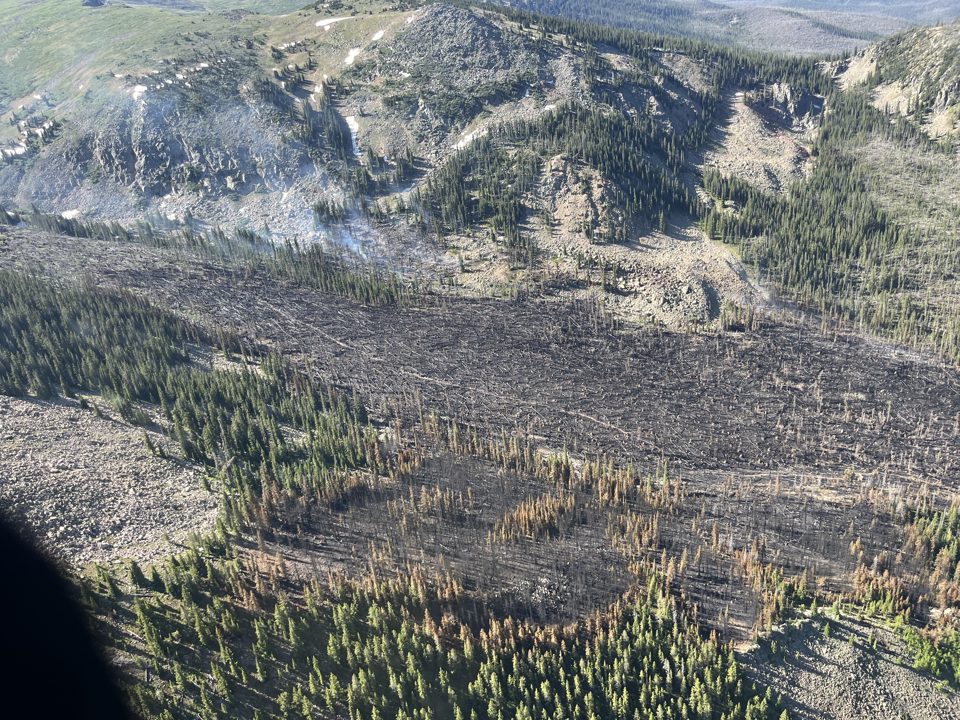
The strategic firing operations that began on Thursday held overnight, and firefighters continued Friday across the northwest edge. Crews stayed late yesterday to complete these operations. Progress was steady but slow as they worked in steep terrain with heavy fuels. The firing operations aim to reduce fuels and create depth between the fire, the firelines, and unburned fuels, which should ultimately lead to more containment.
On the east side, the Flathead Interagency Hotshot Crew finished laying hose in the handline constructed the previous two days into the Consalus Creek drainage. A dozer continued working off the ridge to tie in with this handline.
Equipment operators have completed an indirect line down the west side to a knob southwest of the fire. Crews have almost completed handline and laid hose on the west fire's edge (direct line) down to the same knob.
The falling modules, comprised of highly trained sawyers, are cutting standing dead trees (snags) ahead of firefighters working on direct handline around the fire. Heavy equipment operators continue to open roads, improve current lines, and begin constructing new ones as good routes are identified. Fire managers are close to figuring out where the lines will connect from the east and west on the south side. After that, they will look for additional areas to construct lines closer to the fire to keep the fire footprint as small as possible.
WEATHER AND FIRE BEHAVIOR
Hot and dry conditions are expected throughout the weekend. Today will be sunny and hazy. Maximum temperatures will be around 90 degrees with minimum humidity around 21 percent. Winds will be southwest 4 to 8 mph.
CLOSURES AND SPECIAL MESSAGES
An Idaho Panhandle National Forests closure (Closure Order # 01-04-08-23-002) is effective July 13, 2023, at midnight for the following roads: Forest Service Road (FSR) #1108 from the junction with FSR #333 to the junction with FSR #659; FSR #1094 will remain open for the first 4.5 miles from the junction with FSR #312, but the remainder of FSR #1094 will be closed to the junction with FSR #1108.
For firefighter and public safety, please avoid the following roads if possible: The remaining portion of FSR #1094 not part of the closure order; FSR #312 from the junction with FSR #333 to the junction with FSR #659; FSR #659 in its entirety; and FSR #333 from Highway 57 to the junction with FSR #1108. Anyone Crystal digging off FSR #659, please pull off the road, as heavy equipment and firefighting personnel must be able to get through. Please refer to the incident PIO map for a visual explanation.
There is a Temporary Flight Restriction (TFR) over the fire area. For the safety of aerial resources and firefighters on the ground, please do not fly unmanned aircraft (drones) in the fire vicinity. If you fly, we can't.
Pilot Fire Fact Sheet for Friday July 14 2023
Related Incident:
Publication Type: News
Today’s Date: 07/14/2023
Start Date: 07/01/2023 Location: 20 mi. E. Wikieup, on the O RO Ranch within the Mohon Mountains, Yavapai County
Cause: Human-caused, unknown at this time
Acres: 34,778 Containment: 88%
Evacuations: None Structures Damaged: 0 Destroyed: 0
Summary: Today crews were able to secure additional line and have containment at 88%. All lines are holding in the wind and there is little to no heat remaining within the interior of the fire. Proactive fuels work was completed near infrastructure and cow camps outside of the fire area, primarily along the northeast and southwest sides. All hand crews and engines will be released tomorrow morning, but aircraft remains assigned to the incident and will be used for monitoring and reconnaissance along with satellite-based mapping programs. The fire is located within remote and rugged terrain of the Mohon Mountains, in a sparsely populated area with significant fire history. Monsoon activity, including increased relative humidity levels and precipitation will assist with full containment efforts. On Thursday, the fire was mapped at 34,778 acres and fire operations reports it continues to stay within its footprint. The human-caused Pilot Fire started Saturday, July 1, around 11 am near the O RO Ranch, approximately 20 miles east of the town of Wikieup in Yavapai County. That afternoon, the terrain-driven fire made a run up Pilot Knob and produced a highly visible smoke column noticeable to residents as far away as Kingman.
Resources and Personnel Assigned: 134
Type 1 Hand Crew (HC): 2, Type 2-IA HC: 2, Type 2 (HC): 1, Type 3 Helo: 1, Engines: 6
Weather: Seasonally hot temperatures with potential for records with decreasing RH and minimal winds.
Incident Information:
Twitter: @azstateforestry: https://twitter.com/azstateforestry
Facebook: https://www.facebook.com/arizonaforestry
Thomas Mountain Prescribed Burn San Jancinto Ranger District 71423
Related Incident: 2023 - San Bernardino National Forest Wildfire Crisis Response
Publication Type: News
July 14, 2023 - The dedication and hard work of the firefighters over the last 30 days and in the continuous days to come with managing the Thomas Mountain Prescribed Burn have been commendable. Their efforts to work within the fire footprint and ensure that the fire remains contained within its intended boundaries are crucial for the safety of the community and firefighters.
The San Jacinto Ranger District is placing the Thomas Mountain Prescribed Burn into patrol status and continuing daily monitoring. This is a necessary precautionary measure, and by doing so, the firefighters can promptly address any potential hot spots or flare-ups, effectively maintaining control over the fire. Their vigilance and quick response to any signs of re-ignition or fire activity significantly minimize the risk of the fire spreading beyond the designated area.
The transition to patrol status signifies an important milestone in the management of the prescribed burn. It demonstrates the professionalism and expertise of the firefighting team involved. The ongoing monitoring of the burned area will not only ensure the safety of the environment but also provide reassurance to the local community that the fire is under control.
Magdalena RD Water Canyon Whiskey Hill Wildfires Final Update
Related Incident:
Publication Type: News
Water Canyon & Whiskey Hill Wildfires – FINAL Updates
Magdalena Ranger District
Albuquerque, NM – July 14, 2023
This will be the final release for the Water Canyon and Whiskey Hill Wildfires on the Magdalena Ranger District unless conditions or the situation warrants additional information.
“In addition to our Cibola NF & NGs fire managers and support staff, we extend our appreciation to all of the responders to the Water Canyon Fire, including USFS Salmon Helicopter Rappelers from Central Idaho, Lincoln NF Smokey Bear Hot Shots, Idaho City Hot Shots and aerial resources. Without these highly skilled crews, the response to the Water Canyon Fire would have been much more difficult.
“We also want to recognize the safe and effective wildfire response of the USFS, NMFD and BLM crews to the Whiskey Hill Wildfire. The fewer human-caused fires there are, the more firefighters, aircraft, and equipment there will be available to respond to fires caused by lightning. The challenging work that the interagency fire community does to protect communities, critical infrastructure and natural resources continues to support our mission of Caring for the Land and Serving People.” - Yolynda Begay, Deputy Forest Supervisor, Cibola National Forest & National Grasslands.
Water Canyon Wildfire Start Date / Time: July 10, 2023 / 1443
Cause: Lightning Strike on July 10, 2023 Size: 71 acres
Location: Water Canyon on the Magdalena Ranger District
Resources on Scene: Lincoln NF Smokey Bear Hot Shots.
Containment: 80%. Crews continue to mop up and secure the fire perimeter to mitigate any identified threats to control lines.
Fuels: Juniper, timber and grass.
Whiskey Hill Wildfire Start Date / Time: July 11, 2023 / 1536
Crews continue to secure the fire perimeter to mitigate any identified threats to control lines.
Cause: Lightning strike. Size: 940 acres
Location: Southeast of San Mateo Mts on the Magdalena Ranger District of the Cibola National Forest & National Grasslands.
Resources on Scene: US Forest Service (USFS) Magdalena Ranger District Veteran Crew 3
Containment: 100%. Crews continue to mop up and secure the fire perimeter to mitigate any identified threats to control lines.
Fuels: Juniper, grass and brush.
Fire updates are posted on the Cibola NF & NGs website, New Mexico Fire Information website, and the Cibola NF & NGs Facebook & Twitter pages.
Magdalena Ranger District Office: 575-854-2281
Cibola National Forest and National Grasslands Supervisor’s Office: 505-346-3900
Moore Peak Fire Update 200PM 07142023
Related Incident:
Publication Type: News
The Moore Peak Fire is now estimated to be 600 acres and is 50% contained. Acreage is increased due to better mapping on the ground, not new fire spread. Crews continue to use dozers to construct containment lines around the head of the fire. Two TIFMAS (Texas Interstate Fire Mutual Aid System) strike teams have arrived on scene to support with structure protection and holding perimeters and crews from TAMFS Fredericksburg and Smithville Task Forces are in unified command with Llano County fire departments.
Fire Behavior remains moderate with limited growth but fire weather conditions will persist through the evening hours. Crews successfully conducted a burn operation to ignite areas of unburned fuel and strengthen fire perimeter this morning. Aviation has been helpful in cooling heat on the fire perimeter with 2 helicopters and 3 FireBoss air-tankers dropping water on the fire.
Smoke from Devils Thumb Fire Likely Until Monsoons Arrive
Related Incident: Devil's Thumb Fire
Publication Type: News
GRANBY, Colo. (July 14, 2023) – While firefighters have successfully contained portions of the Devil’s Thumb Fire, residents in Grand County, Boulder County, Gilpin County and surrounding areas may continue to experience the presence of smoke throughout the summer and fall until natural moisture controls the fire.
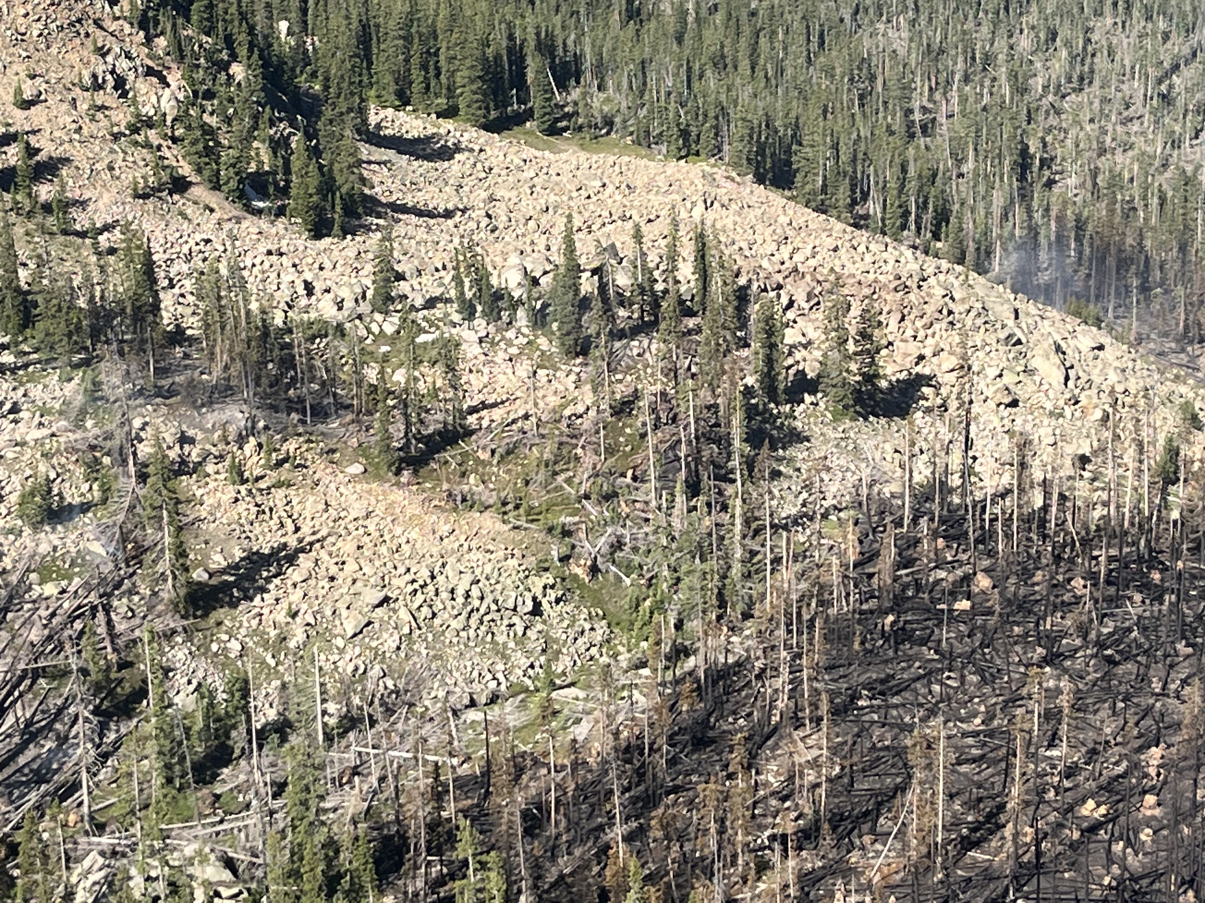
Steep slopes, rugged terrain, and unstable conditions are posing significant challenges to firefighting operations. Located in Wilderness with steep, inoperable terrain, the fire area is full of standing dead and leaning or snagged trees, posing an extremely hazardous situation for firefighters. Additionally, fallen trees are stacked as high as 20 feet in places, making portions of the fire inaccessible. The incident’s leadership is carefully considering these factors in determining how firefighters will engage in suppression efforts.
Ensuring the safety of firefighters and the public is the top priority for the Incident Management Team.
The thick “jackstraw” of vegetation in the fire area is expected to retain heat and continue to burn slowly over time. The region is expected to experience continued hot and dry weather over the coming weeks, which may contribute to occasional active fire behavior and visible smoke. The Incident Management Team is closely monitoring weather conditions and fire behavior and is adjusting strategies accordingly.
Aircraft and specialized equipment have been authorized to aid suppression efforts when there is a potential threat to life and property, but this support will not be able to put the fire out.
Due to the fire’s location just west of the Continental Divide, smoke is expected to drift into Boulder Valley under certain weather conditions, potentially impacting towns from Nederland to the City of Boulder. The visible presence or smell of smoke does not necessarily indicate an immediate threat to life or property. There may still be pockets of burning vegetation within the perimeter, and these hot spots can smolder for extended periods, emitting smoke as the heavy timber slowly burns. Fire crews are continuing to scout and extinguish hot spots when and where it is safe to do so.
The safety and well-being of the community and firefighters remains the top priority. Whenever there is active wildfire in the area, residents and visitors are encouraged to remain informed, prepared, and vigilant. Forest leadership and the Incident Management Team appreciate the patience, cooperation, and support of residents and visitors during this continuing incident.
The Devil’s Thumb Fire started on July 4, 2023, due to a lightning strike in the Indian Peaks Wilderness Area on the Arapaho National Forest, 7 miles northeast of Fraser. It is currently 79-acres, a reduction in size from previous reports due to better mapping and is approximately 25-percent contained. Follow us on Facebook and Twitter. To receive email updates, join our email list and select Forest Health & Fire: Grand County (Winter Park, Fraser, Granby, Grand Lake, Hot Sulphur).
Bee Top Fire Daily Update Friday July 14 2023
Related Incident:
Publication Type: News
NORTHERN ROCKIES TEAM 9 INCIDENT COMMANDER: SHANE MARTIN
Bee Top Fire
Idaho Panhandle National Forests, Sandpoint Ranger District
Fire Information 1-208-953-7021 2023.beetop@firenet.gov
https://inciweb.wildfire.gov/incident-information/idipf-bee-top-fire
July 14, 2023
Location: 5 miles up Lightning Creek Road on Bee Top Mountain
Start Date: 7/1/23 Cause: Lightning Size: 45 acres Containment: 35%.
Total Personnel: 125 Engines: 2 Helicopters: 3 Hand Crews: 3
Yesterday, Klamath Interagency Hotshots Crew (IHC) constructed hand line and saw line along the west flank of the fire, progressing from the bottom of the mountain to the top. With saw line completed on the east flank, Plumas IHC continued to construct hand line from the top of the fire downward and Mad River IHC pushed up from the bottom. The Initial Attack (IA) group began backhauling hose from the contingency line to the west of the fire.
Helicopters cooled the fire with bucket drops and sling-loaded gear and food to crews at spike camps mid-way up the mountain. An Unmanned Aircraft System (UAS) was deployed to identify interior heat and hot spots along the fire perimeter.
Today, crews will continue constructing hand line over previously constructed saw line and securing the fire edge as they go. Klamath IHC will work on the west perimeter of the fire, constructing direct hand line and saw line. Plumas IHC and Mad River IHC will continue constructing hand line on the east flank of the fire and improve existing line. Crews will begin extinguishing hot spots within the fire perimeter to prevent rollouts. Crews will continue to sleep in spike camps on the mountain tonight with aerial support from helicopters slinging in food and gear. The IA group will begin chipping operations and continue to backhaul hose from the contingency lines.
Helicopters will continue to provide bucket drops to cool the fire and allow crews to have better access to the fire perimeter and support crew operations on the mountain. The UAS will continue to search for interior heat and hot spots.
WEATHER AND FIRE BEHAVIOR
A high pressure system will build over the next couple of days, bringing warm and dry air to the fire with light winds Friday and Saturday. Local gusts to 15 mph. This pattern is forecast to breakdown by Monday with dry, gusty winds. Fire behavior will be minimal today, with backing, creeping, and smoldering.
CLOSURES AND SPECIAL MESSAGES
There are currently no road or trail closures associated with the Bee Top Fire, however road, trail, and area closures may occur if the fire reaches pre-determined decision points, creating dangerous conditions. The public is urged to use caution and check Inciweb regularly for the latest fire information before recreating in the area.
July 14 2023 Daily Update
Related Incident:
Publication Type: News
Location: 10 miles west of Coolin, ID, in Pend Oreille County, WA
Start Date: 6/30/2023 Cause: Lightning Size: 305 acres Containment: 10% Total Personnel: 265
Equipment: Heavy Equipment Task Force, 2 Dozers, Excavator, Water Tender, Feller Buncher, Masticator
Hand Crews: 8 + a district module Engines: 2 Aircraft: 1 helicopter Other: 5 Faller Modules, 4 Water Tenders, Ambulance, REMs
Firefighters began conducting strategic firing operations on the northwest side of the fire yesterday to reduce fuels and create depth between the fire, the firelines, and unburned fuels. A 5-person crew was out overnight to monitor the edge where these operations occurred. If conditions allow, crews will continue east across the north perimeter with additional firing operations. On the east side, the Flathead Interagency Hotshot Crew completed the handline up from the Consalus Creek bottom. At the same time, heavy equipment pushed down toward them.
A dozer made progress in opening Forest Service Road (FSR) #333, so firefighters and equipment can access the fire's south side. On the southwest edge, crews have set up sprinkler systems along the fireline. They have also completed a direct handline and laid hose down the fire's west side. An indirect fireline is further out from the fire to the west if needed.
A Type 1 helicopter is now assigned to the fire for water drops, and other helicopters and airplanes are available for various missions if needed.
WEATHER AND FIRE BEHAVIOR
Today will be mostly sunny. Maximum temperatures will be around 85 degrees with minimum humidity around 30 percent. Winds will be south to southwest 3 to 8 mph.
CLOSURES AND SPECIAL MESSAGES
An Idaho Panhandle National Forests closure (Closure Order # 01-04-08-23-002) is effective July 13, 2023, at midnight for the following roads: Forest Service Road (FSR) #1108 from the junction with FSR #333 to the junction with FSR #659; FSR #1094 will remain open for the first 4.5 miles from the junction with FSR #312, but the remainder of FSR #1094 will be closed to the junction with FSR #1108.
For firefighter and public safety, please avoid the following roads if possible: The remaining portion of FSR #1094 not part of the closure order; FSR #312 from the junction with FSR #333 to the junction with FSR #659; FSR #659 in its entirety; and FSR #333 from Highway 57 to the junction with FSR #1108. Anyone Crystal digging off FSR #659, please pull off the road, as heavy equipment and firefighting personnel must be able to get through. Please refer to the incident PIO map for a visual explanation.
There is a Temporary Flight Restriction (TFR) over the fire area. For the safety of aerial resources and firefighters on the ground, please do not fly unmanned aircraft (drones) in the fire vicinity. If you fly, we can't.
Pilot Fire Fact Sheet for Thursday July 13 2023
Related Incident:
Publication Type: News
Today’s Date: 07/13/2023
Start Date: 07/01/2023 Location: 20 mi. E. Wikieup on the O RO Ranch within the Mohon Mountains, Yavapai County
Cause: Human-caused, unknown at this time
Acres: 34,778 Containment: 42%
Evacuations: None Structures Damaged: 0 Destroyed: 0
Summary: More accurate mapping shows the fire at 34,778 acres as of Thursday. Today, crews were able to establish additional black line along the entire west flank and increased containment to 42%. Minor heat still remains along the northeast side and resources continue to cold trail and secure that line. Hotshot and hand crews also finished up more fuels reduction work near infrastructure and cow camps along the southwest side of the fire and within the Mohon Peak-area. Along with crew work, natural fire barriers, previous burn scars, and natural monsoon activity play a role in full suppression efforts. The state’s UAS platform and satellite-based mapping systems continue to be utilized to check for heat throughout the day in some inaccessible areas of the fire. The fire is located in a sparsely populated area with significant fire history, the most recent of which was the 2022 Adobe Fire. As containment increases, some resources will start being released from the incident to rest or stage for any possible new starts.
Resources and Personnel Assigned: 150
Type 1 Hand Crew (HC): 2, Type 2-IA HC: 2, Type 2 (HC): 1, Type 3 Helo: 1, Engines: 6
Weather: Seasonally hot temperatures with increasing RH and moderate winds.
Incident Information:
Twitter: @azstateforestry: https://twitter.com/azstateforestry
Facebook: https://www.facebook.com/arizonaforestry
Boulder Fire Update July 13 2023
Related Incident:
Publication Type: News
Resources: 385 Total Personnel | 7 Hand Crews | 7 Engines | 7 Heavy Equipment | 5 Water Tender
1 Fixed-Wing Aircraft | 7 Helicopters
(Dufur, OR) The Boulder Fire started on July 8 near Boulder Lake Trailhead 26 miles southwest of Dufur in the Mt. Hood National Forest’s Barlow Ranger District. The fire is burning in dead and down debris located in steep, rugged and alpine-like terrain. Approximately 234 acres have burned. The change in size is due to improved mapping data. The efforts of firefighters on the ground combined with air resources have been so effective at limiting fire growth that fire managers are beginning to transition to the mop-up phase of suppression operations. The cause of the fire remains under investigation. A temporary flight restriction is in place. Public and firefighter safety are the highest priorities on the Boulder Fire.
Community Meeting: A community meeting is scheduled for this evening, July 13, at 7 p.m. in the Wamic Community Hall (80192 Emigrant St. in Wamic, Oregon) and on Facebook Live at www.facebook.com/mthoodnf
Yesterday, firefighters continued to work on handlines and hose lays around the fire’s eastern side. While checking for heat beyond the southeast corner of the perimeter, fire crews found and extinguished a new hot spot as well as one that had reignited from the day before. Firefighters used heavy equipment to progress on containment. On the west side, firefighters completed a hose lay along the entire western perimeter and reinforced bulldozer lines throughout the division. Helicopters, dipping from Little Boulder Lake in the center of the fire area, used bucket drops to cool hot spots. Unburned fuels were removed from the northern edge using controlled fire, resulting in 5% containment by the end of yesterday’s shift.
Today, fire crews plan to finish digging handlines, improving containment lines such as roads and bulldozer lines, and installing hose lays in preparation for mop-up operations. Mop-up efforts include carefully checking along containment lines and adjacent areas to locate and extinguish all heat sources so these lines will hold under current and expected fire behavior. Firefighters will also patrol for hot spots and use air resources as needed.
Weather: Conditions are forecast to continue warming and drying through the weekend, and fire managers are preparing for potentially critical fire weather early next week.
Closures and Restrictions: Many of the roadways, campgrounds and trails north and east of Forest Road 48 in the Barlow Ranger District are closed. Due to the high fire danger, open fire and target shooting restrictions have been implemented. For more information or to view the full closure order, visit the Forest webpage at www.fs.usda.gov/alerts/mthood/alerts-notices.
Evacuations: Boulder Lake Campground, Little Boulder Lake, Bonney Meadows Campground, Badger Lake Campground, Camp Windy, and Post Camp Campground are under a Level 3 –Go Now evacuation. Evacuation levels are Level 1 – Be Ready to Evacuate, Level 2 – Be Set to Evacuate, and Level 3 – Go Now. More information is available from the Wasco County Sheriff’s Office at www.facebook.com/WascoCountySheriff.
Public Safety: Firefighters and heavy equipment are working on and around the area roadways, including Forest Road 48. Motorists can help keep firefighters and visitors safe by driving carefully and avoiding these areas. Timothy Lake, a popular recreation site, is being used by water-scooping aircraft. Firefighters are using the Rock Creek OHV Area as a staging area. For everyone’s safety, the public is asked to stay clear of these fire suppression operations.
Smoke: Currently, there are no significant smoke impacts from the Boulder Fire. For air quality updates, visit www.oregonsmoke.org or airnow.gov.
.jpg?VersionId=Zx2AYiyR5YrQh4XtoWdMwQhM8WyYjjJh)