
Additional Road Closures on Mono Lake Ranger District
Related Incident: INYO NATIONAL FOREST--FLOOD RESPONSE
Publication Type: Announcement
Additional Road Closures on Mono Lake Ranger District
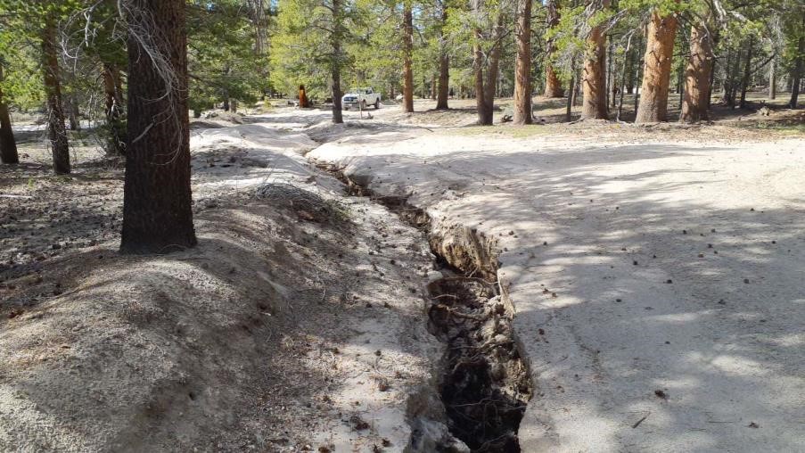
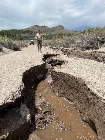
Additional Mono Lake Ranger District Road Closures: 1) Pilot Springs (FS 1S04) Road due to a gully that is 3 to 4-feet deep; and 2) Sagehen Meadow (FS 1N02) Road due to a washout.
SEE PHOTOS BELOW UNDER RELATED INFORMATION OR ABOVE AT PHOTOS TAB
News Release July 17 2023 Cutoff Ridge Fire Burning in Guadalupe Mountains National Park
Related Incident: Cutoff Ridge Fire
Publication Type: News
The Cutoff Ridge Fire continues to burn in the Guadalupe Mountains Wilderness, on the western escarpment of the park. The fire is currently 385 acres and is being managed by ground crews with air support.
The park received a smoke report on July 14th around 3:00 pm, at which time a ground crew was sent to investigate. The ground crew, with the assistance of air support, was able to confirm the fire shortly after the report of smoke was received.
"Firefighter and public safety is our top priority on this, and every, wildland fire in the National Park Service. We are grateful for the hard work of our firefighters, who are managing this fire in very hot weather. This fire is burning in a remote area of the park and currently poses no threat to life or property," said acting Superintendent Theresa Moore.
Hot weather is expected to persist over the area for the remainder of the week. The fire will continue producing smoke and flames may be visible at times. Firefighters will be monitoring the fire’s location and activity and have identified strategies to manage the fire in the coming days.
An emergency closure for all trails in Guadalupe Mountains Wilderness as well as Frijole, McKittrick Canyon, and Dog Canyon was put in place on June 28th due to extreme fire danger, and remains in effect until further notice. For more information on park closures, please refer to the park's news release; file provided below.
Settings - change map background and toggle additional layers
Filter - control incident types displayed on map.
Zoom to your location
Reset map zoom and position
Could not determine your location.
Show Legend
 Wildfire
 Prescribed Fire
 Burned Area
Response
Burned Area
Response Other
Other
Cutoff Ridge Fire
Unit Information
Incident Contacts
Settings - change map background and toggle additional layers
Filter - control incident types displayed on map.
Zoom to your location
Reset map zoom and position
Could not determine your location.
Show Legend
- Wildfire
- Prescribed Fire
- Burned Area
Response
- Other
HTNF 2024 Initial Attack
Unit Information
Incident Contacts
Boulder Fire Update July 17 2023
Related Incident:
Publication Type: News
Resources: 370 Total Personnel | 7 Hand Crews | 9 Engines | 3 Heavy Equipment | 10 Water Tenders
| 1 Fixed-Wing Aircraft | 3 Helicopters
(Dufur, OR) The Boulder Fire started on July 8 near Boulder Lake Trailhead 26 miles southwest of Dufur in the Mt. Hood National Forest Barlow Ranger District. The fire is burning in dead and down debris located in steep, rugged and alpine-like terrain. An estimated 233 acres have burned. The percentage of containment has increased to 46%. The cause of the fire remains under investigation. A temporary flight restriction remains in place over the fire. Public and firefighter safety are the highest priorities on the Boulder Fire.
On Sunday, slightly lower temperature and higher relative humidity moved over the fire area. Fire activity was minimal even as winds picked up with the arrival of a cold front. The unmanned aerial system (UAS) equipped with a heat-sensing device flew over the fire area in search of hot spots and, for the second day in a row, none were detected. The percentage of containment increased to 46% overall and crews are almost finished opening the 4860 Road for better access to the ridge that lies beyond the east side of the fire. Firefighters made additional progress along every side of the fire moving toward mop-up (the process of ensuring that the ground is cool and free of fuels) objectives. Mop-up objectives vary with features such as fuel types, terrain, access and wind exposure but the goal is the same. Mop-up must be completed to a level that’s sufficient to keep the fire from escaping or spotting across existing containment lines, given current and expected conditions. Also, when another fire broke out near LaDee Flats southeast of the Portland area last evening, Boulder Fire managers temporarily assigned a large helicopter and a spotter plane to the initial attack.
Today, mop-up continues as firefighters extend further into the fire’s interior. Crews expect to finish their brushing work on the 4860 Road and will begin backhauling (returning) equipment.
Weather: Temperatures will be much lower, dropping into the 70’s, and the relative humidity will be significantly higher on Monday. Gusty winds are forecast throughout the day but will be strongest in the morning and calmer in the afternoon.
Closures and Restrictions: Many of the roadways, campgrounds and trails north and east of Forest Road 48 in the Barlow Ranger District are closed. Due to the high fire danger, open fire and target shooting restrictions have been implemented. For more information or to view the full closure order, visit the Forest webpage at www.fs.usda.gov/alerts/mthood/alerts-notices.
Evacuations: Boulder Lake Campground, Little Boulder Lake, Bonney Meadows Campground, Badger Lake Campground, Camp Windy, and Post Camp Campground are under a Level 3 – Go Now evacuation. Evacuation levels are Level 1 – Be Ready to Evacuate, Level 2 – Be Set to Evacuate, and Level 3 – Go Now. More information is available from the Wasco County Sheriff’s Office at www.facebook.com/WascoCountySheriff.
Public Safety: Firefighters and heavy equipment continue to work on and around the area roadways, including Forest Road 48. Firefighters are using the Rock Creek OHV as a staging area. Drivers can help keep firefighters and visitors safe by avoiding these areas. Recreationalists planning to use trails and roadways must check closures and restrictions before entering the forest; for everyone’s safety, the public is asked to stay clear of all fire suppression operations.
Smoke: Currently, there are no significant smoke impacts from the Boulder Fire. For air quality updates, visit www.oregonsmoke.org or airnow.gov.
Bee Top Fire Daily Update Monday July 17 2023
Related Incident:
Publication Type: News
NORTHERN ROCKIES TEAM 9 INCIDENT COMMANDER: SHANE MARTIN
Bee Top Fire
Idaho Panhandle National Forests, Sandpoint Ranger District
Fire Information 1-208-953-7021 2023.beetop@firenet.gov
https://inciweb.wildfire.gov/incident-information/idipf-bee-top-fire
July 17, 2023
Location: 5 miles up Lightning Creek Road on Bee Top Mountain
Start Date: 7/1/23 Cause: Lightning Size: 49 acres Containment: 78%.
Total Personnel: 123 Engines: 2 Helicopters: 3 Hand Crews: 3
Yesterday, crews continued to mop up and add “depth to the line”, meaning they were able to mop up further into the fire’s perimeter which allows a greater buffer to the fires edge. The Plumas Interagency Hotshots (IHC) were able to complete mop up and cold trailing on the Northern edge of the fireline and hiked out at the end of shift. Helicopters, throughout the day continued to backhaul gear, as well as carrying in blivets, food, and other essential supplies. They also continued to do bucket work throughout the heat of the day cooling the last few hotspots on the interior of the containment line.
Today, the Plumas IHC will be working on scattering slash and any other consumables that were created when the initial indirect line was constructed. The Klamath IHC and Mad River IHC will patrol the firelines edge and help with backhauling all unnecessary gear off the mountain. The crews will then hike off at end of shift today. Helicopters will start to backhaul the spike camp from the hillside, this includes things like drinking water, coolers, and other gear. In addition, they will be available for any other bucket work that may be required throughout the day. An Unmanned Aircraft System will fly first thing this morning to look for any residual pockets of heat within the fire’s perimeter.
WEATHER AND FIRE BEHAVIOR
An elevated fire weather pattern develops today with the passage of a dry cold front by early morning. Westerly winds will steadily increase speed during the day with gusts to 35 mph on exposed ridges by afternoon. Swift winds from the southwest will be found in the valleys by late morning and through the afternoon. Expect significantly cooler temperatures while dry conditions return by afternoon. Winds should taper off tonight while seasonably cool weather and less wind is anticipated for Tuesday.
CLOSURES AND SPECIAL MESSAGES
There are currently no road or trail closures associated with the Bee Top Fire. However, the public is urged to use caution when recreating in the area and to check Inciweb regularly for the latest fire information.
Campbell Fire Update July 17 2023
Related Incident: Campbell Fire
Publication Type: News
Campbell Fire: Monday, July 17, 2023
Location of Origin: Forest Service Road 8861
Start Date: July 10, 2023
Size: 1,416 acres
Cause: Lightning/Natural
Percent Contained: 27
Personnel: 142
Fuels: Medium Logging Slash
Resources Assigned: 3 Crews, 6 Engines, 2 Helicopters, 2 Dozers, 2 Water tenders
Operations: Firing operations, which have been largely successful in recent days, have been completed on the Campbell fire. Despite some dust devil activity, there were no spot fires yesterday. Fire crews will continue to work on securing containment lines, mopping up remaining hot spots, and mitigating any threats to control features.
Weather: Today’s forecast calls for sunny to partly sunny skies with a 40% chance of precipitation and thunderstorms in the afternoon. Highs are expected to be in the upper 80s with winds from 5 - 10 mph.
Restrictions: The Apache-Sitgreaves National Forests are in Stage 1 Fire Restrictions, learn more at: https://www.fs.usda.gov/alerts/asnf/alerts-notices/?aid=81123.
Smoke: Go to fire.airnow.gov/ to see the latest smoke conditions in your community. Smoke may be visible from Hwy 191, especially at night.
Official fire information can be found on these sites:
- Inciweb: https://inciweb.wildfire.gov/incident-information/azasf-campbell-fire
- Facebook: https://www.facebook.com/apachesitgreavesnfs
- Apache-Sitgreaves website: https://www.fs.usda.gov/asnf
July 17 2023 Daily Update
Related Incident:
Publication Type: News
Location: 10 miles west of Coolin, ID, in Pend Oreille County, WA
Start Date: 6/30/2023 Cause: Lightning Size: 414 acres Containment: 10% Total Personnel: 276
Equipment: Heavy Equipment Task Force, 2 Dozers, Excavator, Water Tender, Feller Buncher, Masticator
Hand Crews: 9 + a district module Engines: 4 Aircraft: 1 helicopter Other: 5 Faller Modules, 5 Water Tenders, Ambulance, REMs
If conditions are right, additional strategic firing operations will occur in the next few days on the east and southeast sides of the fire. An Unstaffed Aerial System (UAS), or drone, will be used for these firing operations, dropping plastic spheres that ignite as they fall. Sunday the drone operators flew a test flight to formulate a plan and determine where the firing will occur. Depending on the weather and fuel moisture levels, fire managers intend to begin ignitions on Tuesday. The firing operations aim to reduce fuels and create depth between the fire, the firelines, and unburned fuels, which should ultimately lead to more containment.
Where previous firing operations occurred on the north end, crews are monitoring the fire and keeping sprinkler systems operating. Firefighters completed lines on the fire's east side and are also running pumps and sprinklers. On Sunday, fire activity picked up on the south edge. A helicopter was used for water drops to dampen fire activity so crews could continue to put sprinklers in place. Several staffed engines are working the night shift to monitor the fire and keep sprinklers running.
The anticipated winds on Monday may cause increased fire behavior and more smoke. Although much of the fire is protected from strong winds, firelines could be tested in areas where conditions align.
WEATHER AND FIRE BEHAVIOR
A dry cold front is expected to pass over the fire midday, causing southwesterly winds and increasing speeds. The front will also drop temperatures sharply with slightly higher humidity levels. Most of the fire will be protected from the strongest winds; however exposed ridges will feel stronger winds. The high temperature will be around 80 degrees and minimum humidity 26 percent. Winds will be south, shifting to southwest 5-9 mph with gusts 14-18 mph.
CLOSURES AND SPECIAL MESSAGES
An Idaho Panhandle National Forests closure (Closure Order # 01-04-08-23-002) went into effect July 13, 2023, at midnight for the following roads: Forest Service Road (FSR) #1108 from the junction with FSR #333 to the junction with FSR #659; FSR #1094 will remain open for the first 4.5 miles from the junction with FSR #312, but the remainder of FSR #1094 will be closed to the junction with FSR #1108.
For firefighter and public safety, please avoid the following roads if possible: The remaining portion of FSR #1094 not part of the closure order; FSR #312 from the junction with FSR #333 to the junction with FSR #659; FSR #659 in its entirety; and FSR #333 from Highway 57 to the junction with FSR #1108. Anyone Crystal digging off FSR #659, please pull off the road, as heavy equipment and firefighting personnel must be able to get through. Please refer to the incident PIO map for a visual explanation.
There is a Temporary Flight Restriction (TFR) over the fire area. For the safety of aerial resources and firefighters on the ground, please do not fly unmanned aircraft (drones) in the fire vicinity. If you fly, we can't.
Boulder Fire Update July 15 2023
Related Incident:
Publication Type: News
Resources: 415 Total Personnel | 8 Hand Crews | 9 Engines | 8 Heavy Equipment | 10 Water Tenders
| 1 Fixed-Wing Aircraft | 6 Helicopters
(Dufur, OR) The Boulder Fire started on July 8 near Boulder Lake Trailhead 26 miles southwest of Dufur in the Mt. Hood National Forest Barlow Ranger District. The fire is burning in dead and down debris located in steep, rugged and alpine-like terrain. Approximately 233 acres have burned. The change in size is due to ever-improving mapping. As of last evening, the percentage of containment had increased to 15%. The cause of the fire remains under investigation. A temporary flight restriction remains in place over the fire. Public and firefighter safety are the highest priorities on the Boulder Fire.
Mop-up was in full force around the entire perimeter on Friday. While firefighters focused mainly on ensuring containment lines are fuels-free and cold, crews also stopped a 20’ x 20’ fire that crossed over an established containment line when a burning tree fell across the north perimeter. Crews at the fire’s southwest corner extinguished several hot spots outside the fire perimeter with the help of bucket drops from helicopters dipping out of Boulder Lake.
Today, the unmanned aerial system (UAS) is flying over the fire area. Equipped with a thermal imaging camera, this UAS is most effective operating early in the morning when the contrast between cooler air temperatures and hot spots is strongest. The additional information provided by the UAS will help firefighters improve their efficiency as they seek out hot spots around the Boulder Fire. Work continues further strengthening containment lines. The need for contingency (or back-up) lines has decreased and crews previously assigned to those operations are joining in the mop-up efforts. The aircraft that had been scooping from Timothy Lake have been reassigned to other incidents but helicopters remain available if needed.
Weather: Very high temperatures and very low humidity are forecast for today and tomorrow before a cold front on Sunday evening brings some temporary relief. High winds are expected on Monday.
Closures and Restrictions: Many of the roadways, campgrounds and trails north and east of Forest Road 48 in the Barlow Ranger District are closed. Due to the high fire danger, open fire and target shooting restrictions have been implemented. For more information or to view the full closure order, visit the Forest webpage at www.fs.usda.gov/alerts/mthood/alerts-notices.
Evacuations: Boulder Lake Campground, Little Boulder Lake, Bonney Meadows Campground, Badger Lake Campground, Camp Windy, and Post Camp Campground are under a Level 3 –Go Now evacuation. Evacuation levels are Level 1 – Be Ready to Evacuate, Level 2 – Be Set to Evacuate, and Level 3 – Go Now. More information is available from the Wasco County Sheriff’s Office at www.facebook.com/WascoCountySheriff.
Public Safety: Firefighters and heavy equipment continue to work on and around the area roadways, including Forest Road 48. Motorists can help keep firefighters and visitors safe by driving carefully and avoiding these areas. Firefighters are using the Rock Creek OHV as a staging area. For everyone’s safety, the public is asked to stay clear of fire suppression operations.
Smoke: Currently, there are no significant smoke impacts from the Boulder Fire. For air quality updates, visit www.oregonsmoke.org or airnow.gov.
Boulder Fire Update July 14 2023
Related Incident:
Publication Type: News
Resources: 415 Total Personnel | 8 Hand Crews | 9 Engines | 8 Heavy Equipment | 10 Water Tenders
| 1 Fixed-Wing Aircraft | 6 Helicopters
(Dufur, OR) The Boulder Fire started on July 8 near Boulder Lake Trailhead 26 miles southwest of Dufur in the Mt. Hood National Forest’s Barlow Ranger District. The fire is burning in dead and down debris located in steep, rugged and alpine-like terrain. Approximately 238 acres have burned. The past week’s hard work has resulted in less active fire and firefighters can focus more on mop-up operations. As of last evening, the percentage of containment had increased to 15%. The cause of the fire remains under investigation. A temporary flight restriction remains in place over the fire. Public and firefighter safety are the highest priorities on the Boulder Fire.
While firefighters focused mainly on mop-up all around the fire on Friday, crews also stopped a 20’ x 20’ fire that slopped over an established containment line when a burning tree fell across the north perimeter. Crews at the fire’s southwest corner crews completed containment lines and hose lays along the western flank. They used hand tools and water from the network of hose lines placed over the past few days to extend containment lines over 10 feet within the fire’s edge. Firefighters also cut off heat sources by attacking pockets of fire directly. Fire crews finished two-thirds of containment lines on the eastern flank. In the remaining one-third on the southeastern corner, crews searched for hot spots and found none in a systematic process called “gridding.”
Today, an unmanned aerial system (UAS) equipped with thermal-imaging equipment is expected to arrive. Fire managers will use the UAS information to more effectively locate hotspots in the area’s thick underbrush. Firefighters will continue mop-up, working to create 10 to 50 feet of cold and fuels-free line around the fire perimeter.
Weather: Today is expected to be warmer and drier than yesterday with light terrain-driven winds. Conditions are forecast to continue warming and drying through the weekend.
Closures and Restrictions: Many of the roadways, campgrounds and trails north and east of Forest Road 48 in the Barlow Ranger District are closed. Due to the high fire danger, open fire and target shooting restrictions have been implemented. For more information or to view the full closure order, visit the Forest webpage at www.fs.usda.gov/alerts/mthood/alerts-notices.
Evacuations: Boulder Lake Campground, Little Boulder Lake, Bonney Meadows Campground, Badger Lake Campground, Camp Windy, and Post Camp Campground are under a Level 3 –Go Now evacuation. Evacuation levels are Level 1 – Be Ready to Evacuate, Level 2 – Be Set to Evacuate, and Level 3 – Go Now. More information is available from the Wasco County Sheriff’s Office at www.facebook.com/WascoCountySheriff.
Public Safety: Firefighters and heavy equipment continue to work on and around the area roadways, including Forest Road 48. Motorists can help keep firefighters and visitors safe by driving carefully and avoiding these areas. Firefighters are using the Rock Creek OHV Area as a staging area. For everyone’s safety, the public is asked to stay clear of fire suppression operations.
Smoke: Currently, there are no significant smoke impacts from the Boulder Fire. For air quality updates, visit www.oregonsmoke.org or airnow.gov.