
Dark Divide and Davis Fires update for July 18 2023
Related Incident:
Publication Type: News
RESERVE, NM, July 18, 2023 – Several fires are being managed under a confine and contain strategy on the Gila National Forest, Reserve Ranger District. All of them were started by lightning strikes last week. Incident Commander Pete Valenzuela assumed command of the Dark Fire, Divide Fire, and Davis Fire yesterday evening. Crews continue to prepare roads and trails around the wildfires to be used to confine and contain them. Firefighters are also scouting range infrastructure, such as fences and plastic stock tanks and pipelines in order to protect these values at risk.
Currently, there are three Hotshot crews assigned, five Type 6 engines, one Type 3 engine, one Fire Use Module, one motor grader, one bulldozer, a helicopter, medical resources, a caterer, and various other overhead. Values at risk include private property, cultural resources, range infrastructure, threatened or endangered species habitat including Mexican spotted owl and Mexican gray wolf, recreation trails, and timber sale units.
“We are seeing moderate fire behavior, with fire flanking, backing, and creeping in grass, brush, and timber understory with occasional single tree torching events during the hottest period of the day,” said Incident Commander Pete Valenzuela. “These fires are cleaning up excessive dead and down material beneath the forest canopy.”
The Davis Fire, located north of Collins Park, east of the Continental Divide Trail, has grown to 100 acres. Crews plan to conduct burnout operations along the Continental Divide Trail in order to use it as a containment feature. As a result, hikers could encounter live fire along part of the section of trail east of Eagle Peak from Cox Canyon trailhead south to Bursum Road. Signs are posted at trailheads north and south of the Davis Fire.
The Dark Fire is located on Corner Mountain about 18 miles southeast of Reserve, New Mexico. It is exhibiting moderate fire behavior, flanking, backing, and creeping in grass, brush, and timber understory within the perimeter of the 1998 B.S. Fire. It has grown to 250 acres. There is a large amount of down woody material throughout the fire area available for fire consumption.
The Divide and Hay fires will be discussed together as Divide Fire. Together they cover approximately 700 acres on the south side of Elk Mountain and in T Bar Canyon. Divide Fire is exhibiting moderate fire behavior, backing, flanking, and torching single trees. It is burning in grass, brush, and timber understory.
All three incidents received minimal precipitation yesterday, moderating fire behavior. The weather forecast calls for hotter than normal temperatures, with 40% to 70% likelihood of showers and thunderstorms daily for the next week. Gusty, erratic winds are expected, associated with passing storms. For more information contact Maribeth Pecotte at 575-388-8211 or Maribeth.Pecotte@usda.gov.
###
USDA Forest Service is an equal opportunity provider, employer, and lender.
Dark Divide and Davis fires update for July 18 2023
Related Incident:
Publication Type: News
RESERVE, NM, July 18, 2023 – Several fires are being managed under a confine and contain strategy on the Gila National Forest, Reserve Ranger District. All of them were started by lightning strikes last week. Incident Commander Pete Valenzuela assumed command of the Dark Fire, Divide Fire, and Davis Fire yesterday evening. Crews continue to prepare roads and trails around the wildfires to be used to confine and contain them. Firefighters are also scouting range infrastructure, such as fences and plastic stock tanks and pipelines – that which is found to be functional will be protected from fire.
Currently, there are three Hotshot crews assigned, five Type 6 engines, one Type 3 engine, one Fire Use Module, one motor grader, one bulldozer, a helicopter, medical resources, a caterer, and various other overhead. Values at risk include private property, cultural resources, range infrastructure, threatened or endangered species habitat including Mexican spotted owl and Mexican gray wolf, recreation trails, and timber sale units.
“We are seeing moderate fire behavior, with fire flanking, backing, and creeping in grass, brush, and timber understory with occasional single tree torching events during the hottest period of the day,” said Incident Commander Pete Valenzuela. “These fires are cleaning up excessive dead and down material beneath the forest canopy.”
The Davis Fire, located north of Collins Park, east of the Continental Divide Trail, has grown to 100 acres. Crews plan to conduct burnout operations along the Continental Divide Trail in order to use it as a containment feature. As a result, hikers could encounter live fire along part of the section of trail east of Eagle Peak from Cox Canyon trailhead south to Bursum Road. Signs are posted at trailheads north and south of the Davis Fire.
The Dark Fire is located on Corner Mountain about 18 miles southeast of Reserve, New Mexico. It is exhibiting moderate fire behavior, flanking, backing, and creeping in grass, brush, and timber understory within the perimeter of the 1998 B.S. Fire. It has grown to 250 acres. There is a large amount of down woody material throughout the fire area available for fire consumption.
The Divide and Hay fires will be discussed together as Divide Fire. Together they cover approximately 700 acres on the south side of Elk Mountain and in T Bar Canyon. Divide Fire is exhibiting moderate fire behavior, backing, flanking, and torching single trees. It is burning in grass, brush, and timber understory.
All three incidents received minimal precipitation yesterday, moderating fire behavior. The weather forecast calls for hotter than normal temperatures, with 40% to 70% likelihood of showers and thunderstorms daily for the next week. Gusty, erratic winds are expected, associated with passing storms. For more information contact Maribeth Pecotte at 575-388-8211 or Maribeth.Pecotte@usda.gov.
###
USDA Forest Service is an equal opportunity provider, employer, and lender.
Boulder Fire Update July 18 2023
Related Incident:
Publication Type: News
Resources: 395 Total Personnel | 7 Hand Crews | 9 Engines | 3 Heavy Equipment | 10 Water Tenders | 1 Fixed-Wing Aircraft | 3 Helicopters
(Dufur, OR) The Boulder Fire started on July 8 near Boulder Lake Trailhead 26 miles southwest of Dufur in the Mt. Hood National Forest Barlow Ranger District. The fire is burning in dead and down woody material located in steep, rugged, alpine-like terrain. An estimated 233 acres have burned. The percentage of containment has increased to 58%. The cause of the fire remains under investigation. A temporary flight restriction remains in place over the fire. Ensuring public and firefighter safety are the highest priorities on the Boulder Fire.
On Monday, lower temperatures and moderate relative humidity persisted over the fire area. Gentle winds had little impact on the fire area, restricting fire activity to the interior of the fire where crews observed limited smoldering and creeping. Containment increased to 58% as crews continued to clear and grade Forest Road 4860 to the east of the fire. Clearing forest roads creates accessible routes for firefighters to build secondary containment lines as needed. Crews continued to make strong progress “mopping-up” around the entire fire perimeter, using water and hand tools to ensure that the ground remains cool and free of flammable materials. This ongoing process ensures that the fire will not spread beyond existing containment lines.
Today, mop-up continues as firefighters venture further into the fire’s interior. Crews expect to finish their grading work on Forest Road 4860 and will start removing heavy equipment from the fire area.
Weather: In the fire area, temperatures will slightly increase to highs in the mid-70s and relative humidity will drop back to levels around 25%. Gentle upslope winds will blow around 5 mph.
Closures and Restrictions: Many of the roadways, campgrounds and trails north and east of Forest Road 48 in the Barlow Ranger District are closed. Due to the high fire danger, open fire and target shooting restrictions have been implemented. For more information or to view the full closure order, visit the Forest webpage at www.fs.usda.gov/alerts/mthood/alerts-notices.
Evacuations: Boulder Lake Campground, Little Boulder Lake, Bonney Meadows Campground, Badger Lake Campground, Camp Windy, and Post Camp Campground are under a Level 3 – Go Now evacuation. Evacuation levels are Level 1 – Be Ready to Evacuate, Level 2 – Be Set to Evacuate, and Level 3 – Go Now. More information is available from the Wasco County Sheriff’s Office at www.facebook.com/WascoCountySheriff.
Public Safety: Firefighters and heavy equipment continue to work on and around the area roadways, including Forest Road 48. Firefighters are using the Rock Creek OHV as a staging area. Drivers can help keep firefighters and visitors safe by avoiding these areas. Recreationalists planning to use trails and roadways must check closures and restrictions before entering the forest; for everyone’s safety, the public is asked to stay clear of all fire suppression operations.
Smoke: Currently, there are no significant smoke impacts from the Boulder Fire. For air quality updates, visit www.oregonsmoke.org or airnow.gov.
Campbell Fire Update July 18 2023
Related Incident: Campbell Fire
Publication Type: News
Campbell Fire: Tuesday, July 18, 2023
Location of Origin: Forest Service Road 8861
Start Date: July 10, 2023
Size: 1,416 acres
Cause: Lightning/Natural
Percent Contained: 48
Personnel: 139
Fuels: Medium Logging Slash
Resources Assigned: 2 Crews, 6 Engines, 2 Helicopters, 1 Dozers, 1 Water Tender
Operations: A weather system moved into the area of the fire yesterday afternoon, but no precipitation was received. Snags are smoldering within the interior of the fire and smoke is expected to continue as a result. Firefighters will work today to secure fire edges, mop up hot spots, and mitigating threats to containment lines.
Weather: Today’s forecast calls for thunderstorm activity with a 60% chance of precipitation, temperatures in the upper 80s, and winds from 5 - 10 mph with gusts up to 20 mph.
Restrictions: The Apache-Sitgreaves National Forests are in Stage 1 Fire Restrictions, learn more at: https://www.fs.usda.gov/alerts/asnf/alerts-notices/?aid=81123.
Smoke: Go to fire.airnow.gov/ to see the latest smoke conditions in your community. Smoke may be visible from Hwy 191, especially at night.
Official fire information can be found on these sites:
- Inciweb: https://inciweb.wildfire.gov/incident-information/azasf-campbell-fire
- Facebook: https://www.facebook.com/apachesitgreavesnfs
- Apache-Sitgreaves website: https://www.fs.usda.gov/asnf
Bee Top Fire Daily Update Tuesday July 18 2023
Related Incident:
Publication Type: News
NORTHERN ROCKIES TEAM 9 INCIDENT COMMANDER: SHANE MARTIN
Bee Top Fire
Idaho Panhandle National Forests, Sandpoint Ranger District
Fire Information 1-208-557-8813 2023.beetop@firenet.gov
https://inciweb.wildfire.gov/incident-information/idipf-bee-top-fire
July 18, 2023
Location: 5 miles up Lightning Creek Road on Bee Top Mountain
Start Date: 7/1/23 Cause: Lightning Size: 45 acres Containment: 88%.
Total Personnel: 87 Helicopters: 2 Hand Crews: 3
Today will be the last update on behalf of the Northern Rockies Incident Management Team 9. The Idaho Panhandle National Forests will publish further updates as any change in conditions warrant. On Wednesday, the Northern Rockies Incident Management Team 9 will transfer command back to the Sandpoint Ranger District at 0600.
Yesterday, crews were able to finish mop up, extinguishing burning material to add depth to the containment lines. Both the Klamath and Mad River Inter-Agency Hotshots (IHC) were able finish their section of containment line and backhauled the last bit of gear from Bee Top Mountain. Plumas (IHC) was able to complete their work scattering slash that was initially cut during the indirect line construction. Helicopters ran a cycle of water buckets on the fire and retrieved gear from the hillside.
Today, the Bee Top Fire will be put in “Patrol Status,” meaning crews will check on the fire periodically throughout the day, but no more line construction is needed at this time. Interior smoke may be visible during the day as only the outer perimeter is out cold. This is due to the steep nature of the hillside and is commonplace on larger fires where it is impractical to cold trail 45 acres of ground.
WEATHER AND FIRE BEHAVIOR
Tuesday, Wednesday, and Thursday will bring lighter terrain driven winds. Another warming and drying trend will occur as well on starting on Wednesday. Additional increase in southwest wind is likely late in the week but likely not as strong as what occurred Monday.
CLOSURES AND SPECIAL MESSAGES
There are currently no road or trail closures associated with the Bee Top Fire.
July 18 2023 Daily Update
Related Incident:
Publication Type: News
Location: 10 miles west of Coolin, ID, in Pend Oreille County, WA
Start Date: 6/30/2023 Cause: Lightning Size: 444 acres Containment: 10% Total Personnel: 285
Equipment: Heavy Equipment Task Force, 2 Dozers, Excavator, Water Tender, Feller Buncher, Masticator
Hand Crews: 10 + a district module Engines: 4 Aircraft: 1 helicopter, 1 Unmanned Aerial System
Other: 5 Faller Modules, 5 Water Tenders, Ambulance, REMs
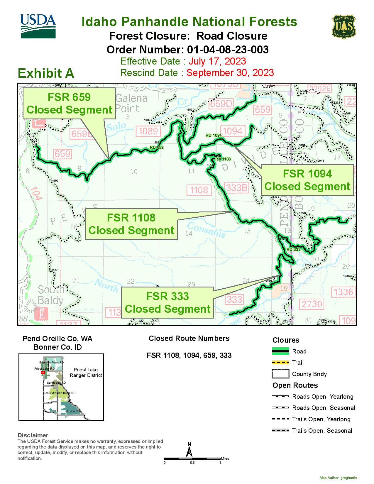
The Idaho Panhandle National Forests issued an emergency closure (Closure Order # 01-04-08-23-003) that went into effect July 18, 2023, at midnight, replacing Closure Order #01-04-08-23-002 issued on July 13.This emergency closure has been issued for public safety and prohibits all forms of travel on: Forest Service Road (FSR) #1108 from the junction with FSR #333 to the junction with FSR #659; FSR #1094 will remain open for the first 4.5 miles from the junction with FSR #312, but the remainder of FSR #1094 will be closed to the junction with FSR #1108. Additional road closures now include FSR #659 from the junction with FSR #312 to the junction with FSR #659B; FSR #333 from the junction with FSR #2730 to its terminus.
An Unmanned Aerial System (UAS), or drone, has been reassigned to the Consalus Fire from the Bee Top Fire. On Monday morning, the UAS flew an infrared (IR) flight to map the fire and identified a spot fire outside the north fireline. Crews were able to get a line around and water on it and catch it at 1.3 acres. Many trees have come down over the last few days and can throw sparks a long way. Although firefighters have been checking for spots, it was likely smoldering in the duff and fanned by the wind. Crews will continue to monitor and patrol the north end.
Yesterday crews ordered the helicopter for water drops to cool a pocket that was burning at a higher intensity on the northwest side. Firefighters continue to run sprinkler systems on the firelines around the fire. Several staffed engines are working the night shift to monitor the fire and keep sprinklers running.
Depending on weather and fuel moisture, fire managers are planning for additional strategic firing operations in the Consalus Creek area on Tuesday. The firing operations aim to reduce fuels and create depth between the fire, the firelines, and unburned fuels, which should ultimately lead to more containment. On the southeast side, the fire is backing down through the understory to the firelines where firefighters can stop it.
WEATHER AND FIRE BEHAVIOR
Today will be mostly sunny. The high temperature will be 81-83 degrees and minimum humidity 25-29 percent. Transport winds will be northwest 5 to 10 mph. Fire has been active with group torching, flanking, and backing.
CLOSURES AND SPECIAL MESSAGES
For firefighter and public safety, please avoid the following roads if possible: The remaining portion of FSR #1094 not part of the closure order; FSR #312 from the junction with FSR #333 to the junction with FSR #659; and FSR #333 from Highway 57 to the junction with FSR #1108. Please refer to the incident PIO map for a visual explanation.
There is a Temporary Flight Restriction (TFR) over the fire area. For the safety of aerial resources and firefighters on the ground, please do not fly unmanned aircraft (drones) in the fire vicinity. If you fly, we can't.
Settings - change map background and toggle additional layers
Filter - control incident types displayed on map.
Zoom to your location
Reset map zoom and position
Could not determine your location.
Show Legend
 Wildfire
 Prescribed Fire
 Burned Area
Response
Burned Area
Response Other
Other
Flat Fire
Unit Information
Incident Contacts
Closure Order 01040823003
Related Incident:
Publication Type: Closures
Emergency Road Closure, Forest Service Roads (FSR) 1108, 1094,659, 333 is effective July 18, 2023 at midnight.
Closure Order Map 01-04-08-23-003
Mon, 07/17/2023 - 21:55
Emergency Road Closure, Forest Service Roads (FSR) 1108, 1094,659, 333 is effective July 18, 2023 at midnight.
National Weather ServiceNWS Reno Office Forecast for July 17July 19
Related Incident: INYO NATIONAL FOREST--FLOOD RESPONSE
Publication Type: Announcement
National Weather Service-(NWS) Reno Office Forecast for July 17-July 19
Not Record-Breaking Heat, but still Hot this Week. Breezy with Isolated Storms through Mid-week
If you woke up this morning and thought it was warm out, you were right. Reno tied it's warmest low temperature on record with this morning's low only dipping down to 77° thanks to blistering temperatures this weekend and cloud cover overnight. This weekend was one for the record books as Saturday and Sunday set new records with 106° and 108°respectively in Reno. Yesterday's 108° reading tied Reno's all time hottest temperature on record which has occurred 3 times before. While this week will be a little "cooler", temperatures will still be quite hot with upper 90s to near 100 for western Nevada valleys and upper 80s to near 90 for Sierra valleys. Otherwise we will be looking for chances for isolated afternoon thunderstorms and gusty westerly winds each afternoon through Wednesday which may present some fire weather concerns in areas where fuels are receptive.
KEY POINTS
- Less Hot, but still Hot this Week
- Fire Weather Concerns: Breezy & Dry, Isolated Storms.
- High Stream/River Flows continue, totally depending on fire activity levels today.
CHANGES FROM PREVIOUS BRIEFING
Some simulations showing another round of elevated showers and thunder late Tuesday night into Wednesday morning for the Eastern Sierra and Mineral County.
WEATHER RISK OUTLOOK
Risk levels incorporate potential impacts from weather hazards and likelihood of occurrence for a reasonable worse-case scenario.
SEE SPREADSHEET IMAGE FOR JULY 5-JULY 11 WEATHER RISK OUTLOOK BELOW UNDER RELATED INFORMATION
DETAILS
- Heat Continues
Not as hot as this past weekend (Reno’s record hottest weekend), but western NV valleys will continue to see highs in the upper-90s to near 100° with Sierra valleys in the mid-upper 80s. We could heat back up above 100° in the lower valleys by this weekend.
- Fire Weather Concerns
Hot and dry conditions will further cure fuels. Enhanced W/SW winds this afternoon may yield critical conditions in receptive fuels. Isolated thunderstorm chances shift east of US-395/I-580 and south of I-80 this afternoon-evening, then south of US-50 Tues-Wed, but are trending wetter. Typical afternoon breezes expected Tues-Fri.
- Rivers and Streams
Eastern Sierra including the Walker River system continue running at elevated levels, but peak flows have decreased on the Walker due to decreasing reservoir releases and diminishing snowpack. Watch for potential renewed high flows through Tuesday AM on Mono County small streams, especially Mono Basin and to the south.
FOR MORE INFORMATION
For the latest weather forecast updates, visit:
Mammoth Area and Mono County:
7-Day Forecast 37.66N 118.97W (weather.gov)
Bishop Area and Inyo County:
Road openings and closures update on Inyo National ForestJuly 13
Related Incident: INYO NATIONAL FOREST--FLOOD RESPONSE
Publication Type: News
Road openings and closures update on Inyo National Forest
BISHOP, Calif., July 13, 2023 — It’s no secret this past winter’s effects on the roads within Inyo National Forest (Forest) have been long-lasting. The Forest has continued reassessing roads after record-breaking snowmelt runoff and thunderstorms caused heavy damage to numerous Off-Highway Vehicle (OHV) routes and has developed a prioritization protocol for repair based on access for fire personnel, developed recreation sites and high-use areas.
With it still being a very dynamic situation expected to last into the summer and beyond, the forest has some updates to share regarding the reopening of some roads with additional closures of others, broken down by each Ranger District:
MAMMOTH RANGER DISTRICT:
Lake Mary Road and roads within the Lakes Basin: opening Friday, July 14 at 8:00 a.m.
o Hazard tree abatement will continue and there will be temporary traffic stops.
o The only campground open will be Twin Lakes.
o Coldwater Creek is overflowing. Drive slowly, and do not park in flooded shoulders.
o Parking is extremely limited. Please check the ESTA website for trolley information.
Reds Meadow Road will remain closed up to the Mammoth Mountain Inn/Main Lodge. Admin access is only allowed past this point as staff continue clearing the road, assessing for damage and conducting trainings before ESTA can begin providing shuttle service. More information will be forthcoming jointly from the Inyo National Forest and Devils Postpile National Monument regarding the reopening of Reds Meadow Road to the public.
Mammoth Ranger District staff would like to thank the Town of Mammoth Lakes and Mammoth Mountain Ski Area for their continual assistance in clearing these roads!
WHITE MOUNTAIN RANGER DISTRICT:
Buttermilk Loop Road is now open.
Silver Canyon Road is now open.
Coyote Flat, Sugarloaf Road, Sand Canyon, Wyman Canyon, and White Mountain Road (past Patriarch Grove) remain closed.
O Of these roads, Coyote Flat and Sand Canyon are the top priority.
The Coyote Flats area has been and continues to be one of the worst-affected roads on the forest from snowmelt runoff and thunderstorm damage this year. After a recent attempt to work on the road forest service engineering staff had to retreat because the road surface was unstable and unsafe for them to operate their equipment. Staff then headed four miles further up the road and found a new, larger gully washout. It was then determined that the road closure would need to be kept in place while further planning for repairs is conducted, as the type of work needed will not be supported by the current heavy equipment on-hand.
Forest Service staff are working on agreements with individuals in the community who have the proper and right-sized heavy equipment and also with volunteer groups such as Valley Outdoors to organize additional public work-day events, as have happened in the recent past.
“With the now dwindling budget available to utilize in ordering equipment, the forest is grateful for a community that is so enthusiastic about getting involved in their public lands,” said Mike Wiese, Incident Commander for the team managing the storm damage. “The Forest continues working with locals to facilitate a faster reopening, while also ensuring safety to those involved.”
MONO LAKE RANGER DISTRICT:
•Big Springs Road and Sawmill Cutoff Road are currently being repaired for fire access.
O Big Springs Road has been repaired as of July 7 and is being prepared for opening shortly.
•Walker Lake Road (Forest Road 1S23), Bohler Canyon Road (Forest Road 1N106), Horse Meadow Road (Forest Road 1N16), Forest Roads 1S131, 1S131A, 1S131B remain closed due to storm damage.
O Walker Lake and Horse Meadow Roads are the priority for repairs.
O Three new roads have been partially closed this week due to excessive storm damage as well:
Sagehen Meadow Road (Forest Road 1N02 (junction of 1N02G and1N02H)
Wild Horse Meadow Road (Forest Road 1S56 (junction of 1S17and1S56B)
Pilot Springs Road (Forest Road 1S04 (junction of 1S167 and 1S04J)
All roads listed in the Closure Order are open to foot traffic or bicycles. Motorized vehicles are not.
Forest engineers are working diligently to address and repair the above damaged roads, get campgrounds open, and set up new volunteer agreements to fix roads as well.
Operations have been challenging, but are moving in the right direction. We ask for your continued patience and understanding as we continue to deal with the effects of this year’s historical precipitation and the limited resources and staff we have to address it.
If you would like to get involved with efforts to help repair these roads, please contact our partner organization at Valley Outdoors: Volunteer@valleyoutdoors.org.
For more information on Inyo National Forest Road Conditions:
www.fs.usda.gov/goto/inyo/alerts-notices/roadconditions
Other agencies manage roads that are partially Forest Service-owned or lead into our roads.
Please “know before you go” by visiting their websites:
Inyo County: https://www.inyocounty.us/services/public-works/news/inyo-county-road-openclosed-status
Mono County: https://monocounty.ca.gov/roads
Los Angeles Department of Water and Power: ladwpeasternsierra.com
BLM - Bishop Field Office: https://www.blm.gov/office/bishop-field-office
CalTrans: quickmap.dot.ca.gov
Nevada Department of Transportation: https://www.nvroads.com/
Forest officials want to remind the public of the following:
• Driving around closed roads, boulders, blockades, or driving over carsonite posts or through ruts creates further resource damage and also endangers the traveler and others. It can also create a further backlog of repair work, causing road closures to last longer.
• Region-wide, the road damage repair is so extensive that repairs may not be done in a timely enough manner before reopening. Therefore, if a road appears to be fine to drive but it is officially closed, it is imperative that you don’t.
• Travelling over snow-covered roadways results in water flowing down ruts created by the vehicles, causing road damage and erosion.
• Violation of entering closed roads is punishable by a fine of $5,000 or less for an individual or $10,000 for an organization, or imprisonment for not more than six months or both.