
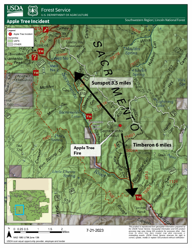
Apple Tree Fire Update July 21 2023
Related Incident: Apple Tree Fire
Publication Type: News
Start Date / Time: July 18, 2023, 9:00 pm
Cause: Lightning
Size: 62 acres
Containment: 2%
Location: East of Sacramento Lookout Tower, 6 mi. north of the community of Timberon, 3.5 miles southeast of Sunspot, NM.
Fire Strategy: Confine and contain
Resources: 1 type-1 crew, 1 type-2 crew, 1 fuels crew, 1 dozer, 2 engines, 1 module, additional support personnel. Total Personnel: 90
Fire behavior: Low/Moderate fire behavior.
Types of vegetation in the area (aka fuels): Mixed conifer, locust and oak brush, dead and down trees.
Values at risk: No structures or communities are at immediate risk.
Update: Fire plays an important role in the forest ecosystem by removing dead and down trees on the forest floor, which reduces risk for high-intensity fire in the future and allows for regeneration of new grasses and plants. This creates a healthy, more resilient forest.
After carefully considering the weather, values at risk and vegetation in the area, fire managers will manage the Apple Tree Fire using a confine-and-contain strategy using existing roads, trails and constructed fireline. A confine-and-contain strategy under the current conditions, allows fire to move naturally across the landscape, providing ecological benefits to plants and wildlife. In the case of the Apple Tree Fire, there are no homes at risk and no major infrastructure in the area. Fire behavior has been low to moderate, while still being successful at reducing ground fuels. In the long-term, allowing fire activity to clear overgrown areas contributes to overall forest health and reduces fire risk on the forest.
Today, firefighters will continue with their confine and contain strategy which includes removing vegetation along the roads and trails and widening other firelines to ensure they have a secure perimeter as the fire progresses across the land towards the firelines.
Smoke: Smoke will be visible in coming days as the fire continues to progress across the landscape.
Visitor Information: The road to Sacramento Lookout is blocked due to fire equipment in the area. Visitors are advised to stay out of the fire area to allow for firefighters to quickly and safely access the fire. Please avoid Apple Tree Trail, Apple Tree Canyon and Forest Service Road 64 near Sacramento Lookout.
Evacuations: None
Road Closures: None
Injuries/Fatalities: None
More Information:
Facebook: https://www.facebook.com/AppleTreeFire2023;
Twitter: @LincolnUSForest
Other: www.NMFireInfo.com
You can expect another update mid-day tomorrow.
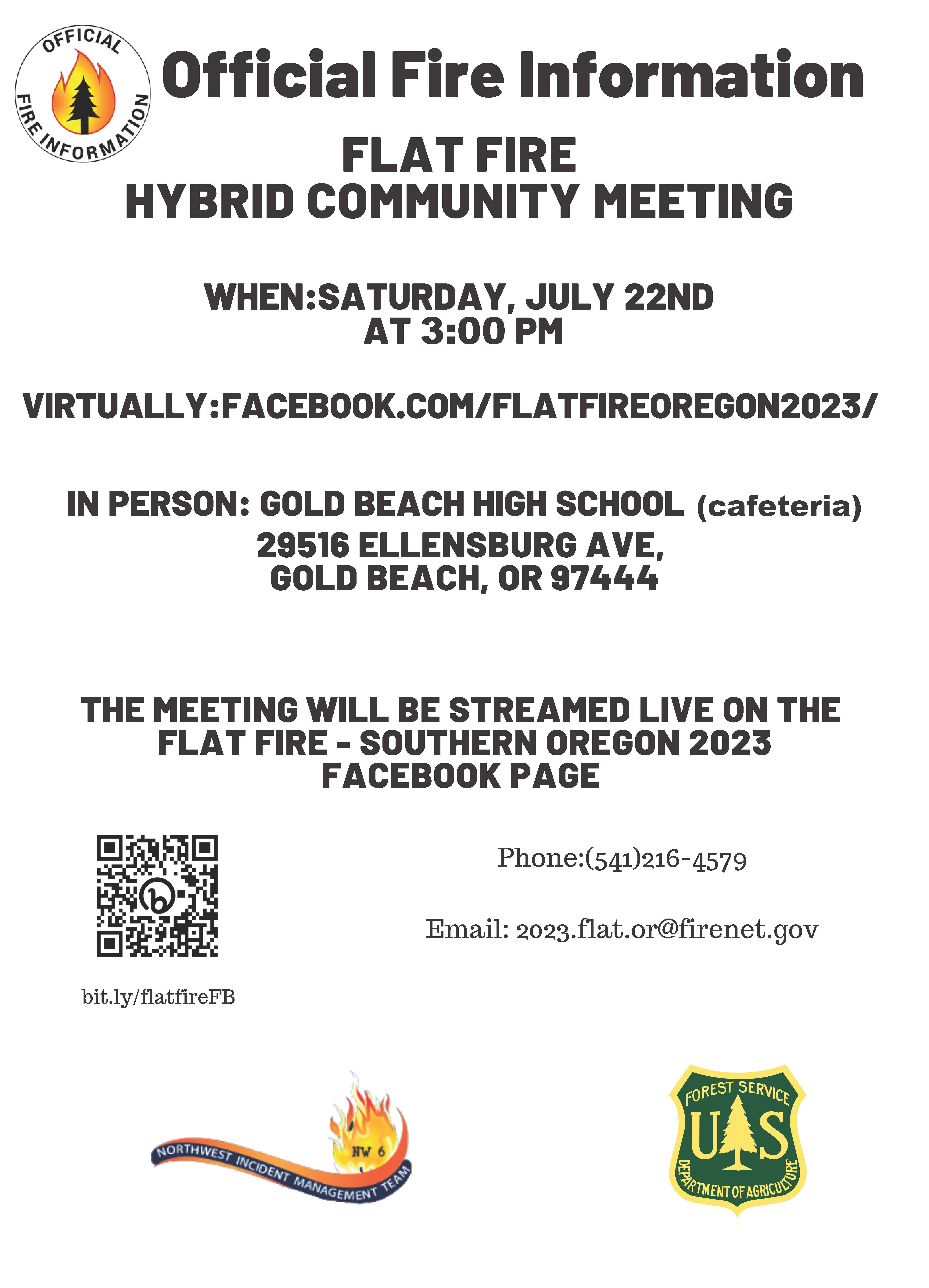
Flat Fire Community Meeting Hybrid
Related Incident: Flat Fire
Publication Type: Announcement
Flat Fire
Hybrid community meeting
When: Saturday, July 22nd
at 3:00 PM
Virtually:facebook.com/flatfireoregon2023/
In Person: Gold Beach High school
29516 Ellensburg Ave,
Gold Beach, OR 97444
The meeting will be streamed live on the
Flat Fire - Southern Oregon 2023
Facebook page

Flat Fire Morning Spanish Update 7212023
Related Incident: Flat Fire
Publication Type: News
July 21, 2023
Flat Fire Morning Update
Extensión: 15,217
Fecha de Inicio: 15-julio-23
Origen: 2 millas Sur of Agness, OR
Causa: Bajo Investigación
Personal: 936
Recursos: 11 camiones l 32 escuadrillas l 4 bulldozers l 4 cisternas l 8 masticador l 8 helicópteros
Reunión Comunitaria: El día de mañana, sábado 22 de julio a las at 3pm: en la cafetería de la escuela secundaria en Gold Beach, 29516 Ellensburg Ave Gold Beach, OR 97444, y transmitido en vivo en la página de Facebook Flat Fire.
Situación actual: En la noche de ayer, no fue posible realizar vuelos infrarrojos debido a la baja visibilidad. El numero de acres en el incendio permanecerá siendo el mismo hasta que sea posible reanudar dichos vuelos. El fuego continúa presentándose más activo hacia el área de Lawson Creek a lo largo de la cumbre de Wildhorse. En las zonas Norte y Sureste, se puede observar que el fuego aún se encuentra activo y con un comportamiento moderado, por lo tanto, está propagándose de una manera mínima. La propagación del fuego es debido a las cantidades enormes de madera y vegetación sin vida en el terreno.
Actividades diurnas: Los bomberos están a punto de completar el trabajo de preparacion con la compañía maderera South Coast Lumber en la carretera forestal 3318 (Wildhorse). Los bomberos continuaran conduciendo pequeñas operaciones de quema para tratar de detener un poco la propagación del fuego y de esta manera asegurando que el incendio permanezca fuera del área de Gold Beach y Agness. Asimismo, los grupos de bomberos encargados de proteger la infraestructura seguirán en pie garantizando que las construcciones cerca del fuego no sufran daños debido al incendio.
Evacuaciones: El día de ayer, el Alguacil en la ciudad Curry emitió un Nivel de Evacuación 2 (esté listo para salir) para las áreas de Agness y Quosatana Creek (no para el campamento Quosatana). Permanece en pie el Nivel de Evacuación 3 (salga del área) el cual se inicio en julio 15, en el área de Old House Creek Road (al final de la calle Oak Flat Road y Spud Road). La ciudad de Curry está enviando noticias de evacuación utilizando el sistema Everbridge, lo cual proporciona las noticias a través de vía telefónica. Si aun no lo ha hecho, por favor anotese en el programa, visitando el website de Curry County y marque en el link para las notificaciones Everbridge: https://www.co.curry.or.us/departments/emergency_management/index.php
Condiciones climáticas: Un viento fuerte en el terreno permanecerá en el área en los próximos días formándose un alto porcentaje de humedad y reduciéndose las condiciones inestables en el incendio.
Impacto del humo: Pronostico en la presencia del humo, puede encontrarse https://www.oregonsmoke.org/?m=1
Cierres de áreas: El Bosque Nacional de Rogue River-Siskiyou, ha emitido una orden de cierre en el área del incendio la cual incluye senderos, carreteras y parte del rio Illinois. Por favor, maneje con precaución al encontrarse en esta zona alrededor del incendio debido al incremento en el tráfico de los bomberos y sus equipos. Visite bit.ly/RRSNFClosures
Medidas de restricción: Se han establecido Restricciones en el área: fs.usda.gov/rogue-siskiyou
Línea telefónica:(541)216-4579 Medios Informativos: (541)237-6369 Email: 2023.flat.or@firenet.gov
Facebook: facebook.com/flatfireoregon2023 Twitter: twitter.com/FlatFireOR2023 Inciweb: bit.ly/FlatFireOR
Settings - change map background and toggle additional layers
Filter - control incident types displayed on map.
Zoom to your location
Reset map zoom and position
Could not determine your location.
Show Legend
 Wildfire
 Prescribed Fire
 Burned Area
Response
Burned Area
Response Other
Other
Apple Tree Fire
Unit Information
Incident Contacts
Hayden Fire Closure Order 04132304 72123
Related Incident:
Publication Type: Closures
Order Number: # 04-13-23-04
U.S. Department of Agriculture, U.S. Forest Service
Salmon-Challis National Forest
Leadore Ranger District
Hayden Fire Closure Order
PROHIBITIONS
Pursuant to16 U.S.C. § 551 and 36 CFR 261.50(a) and (b), the following acts are prohibited on National Forest System (NFS) lands, roads and trails in the Leadore Ranger District, Salmon-Challis National Forest, shown on the attached map incorporated into this Order as Exhibit A (the “Described Area, Roads and Trails”):
- Going into or being upon the Described Area, 36 C.F.R. § 261.52 (e).
- Being on the Described Road, 36 C.F.R. § 261.54 (e).
- Being on the Described Trails, 36 C.F.R. § 261.55 (a).
EXEMPTIONS
Pursuant to 36 C.F.R. § 261.50(e), the following persons are exempt from this Order:
- Persons with Forest Service Permit No. FS-7700-48 (Permit for Use of Roads, Trails, or Areas Restricted by Regulation or Order), specifically exempting them from this Order or a written determination by a Forest Service authorized officer that a permit is not required under 36 C.F.R. § 251.50(e)(1) or (2).
- Any Federal, State, or local officer, or member of an organized rescue or fire fighting force in the performance of an official duty.
DESCRIBED AREA AND ROADS
All NFS lands, roads and trails on the Leadore Ranger District of the Salmon-Challis National Forest within the area bounded by the following: starting at the junction of the Salmon-Challis National Forest boundary and National Forest System Road (NFSR) #008 Hayden Creek Road, then following the Salmon-Challis National Forest Boundary to its intersection with Rye Grass Creek Road, then following the ridgeline south to the junction with NFSR #162 Kadletz Creek Road, then following NFSR #162 Kadletz Creek Road to the ridgeline southwest to the summit of Long Mountain, then following the ridgeline north to an unnamed tributary of the North Fork Morgan Creek, then following North Fork Morgan Creek to its junction with National Forest System Trail (NFST) #4243 Little Morgan Cow Creek Trail, then following NFST #4243 Little Morgan Cow Creek Trail to NFSR #093 Morgan Creek Road, then following NFSR #093 Morgan Creek Road to the Salmon-Challis National Forest Boundary, then following the Salmon-Challis National Forest Boundary to its intersection with NFSR #096 Patterson-Eight Mile Road, then following NFSR #096 Patterson-Eight Mile Road north and northeast to the ridgeline between Patterson Creek and the East Fork of Patterson Creek, then following the ridgeline between Patterson Creek and the East Fork of Patterson Creek to ridgeline that forms the hydrologic divide between the Pahsimeroi Valley and the Lemhi Valley, then following the ridgeline that forms the hydrologic divide between the Pahsimeroi Valley and the Lemhi Valley to the unnamed tributary to Mill Creek south of Mill Lake, then following the unnamed tributary to Mill Creek south of Mill Lake to NFSR #006 Mill Creek Road, then following NFSR #006 Mill Creek Road to its intersection with NFSR #010 Hayden Creek-Mill Road, then following NFSR #010 Hayden-Mill Creek Road to its intersection with the Salmon-Challis National Forest boundary, then following the Salmon-Challis National Forest boundary to the point of origin at the junction of the Salmon-Challis National Forest boundary and NFSR #008 Hayden Creek Road.
ADDITIONAL DESCRIBED ROADS AND TRAILS
This closure shall include the following National Forest System Roads and Trails outside of the designated area described above:
Roads:
- That portion of NFSR #213 Allison Creek Road that is north and east of its junction with
- NFSR #089 Upper Allison Creek Road
- NFSR #012 Blue Jay Mine Road
- NFSR #011 Ray Mine Road
- NFSR #244 Patterson Spur #3
Trails:
- NFST #6230 North Fork McKim Creek Trail
- NFST #6143 Devils Lake Trail
The following Road and Trail which make up portions of the boundary of the closure area remain open to travel:
- That portion of NFSR #093 Morgan Creek Road from the Forest boundary north to its junction with NFST #4243 Little Morgan-Cow Creek Trail
- NFST # 4243 Little Morgan-Cow Creek Trail
PURPOSE
The purpose of this Order is to protect public health and safety from the effects of the Hayden Fire.
IMPLEMENTATION
- This Order shall be in effect from July 21st, 2023, at 08:00 through September 30th, 2023, at 12:00, unless rescinded.
- A map identifying the Described Area, Roads and Trails is attached and made part of this Order as Exhibit A. For a digital version of this Order and Exhibit A, go to https://www.fs.usda.gov/alerts/r4/alerts-notices.
- Unless otherwise expressly defined in this Order, the terms used in this Order are defined by the regulations of the Secretary of Agriculture, 36 C.F.R. Chapter II, Parts 200-299. If there are terms in this Order that are not expressly defined in the Order or 36 C.F.R. Chapter II, Parts 200-299, their meaning shall be determined by their plain language definitions. A violation of the above prohibitions is punishable as a Class B misdemeanor by a fine of not more than $5,000 for individuals and $10,000 for organizations, or by imprisonment for not more than six months, or both. 16 U.S.C. § 551; 18 U.S.C. §§ 3559, 3571, and 3581.
- Contact the Leadore Ranger District in Leadore, Idaho at (208) 768-2500, the Challis-Yankee Fork Ranger District in Challis, Idaho at (208) 879-4100, or the Salmon-Challis National Forest Supervisor’s Office in Salmon, Idaho at (208) 756-5100, for more information about this Order.
- This Order supersedes any previous Orders prohibiting the same or similar acts in the same Described Area and Roads.
IDSCF Closure Order 04-13-23-07 Map
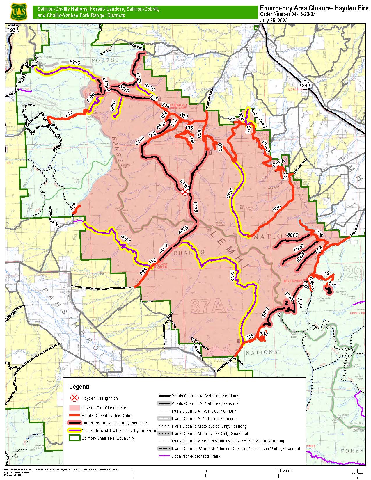
Fri, 07/28/2023 - 13:26
Closure Order 04-13-23-07 Map
Hayden Fire Update July 21 2023
Related Incident:
Publication Type: News
Summary: The Hayden Fire started on Wednesday, July 19th, 2023, at approximately 11:30 am. The fire is located in the Lemhi Range, 18 miles west of Leadore, Idaho. The terrain is difficult, and the fire is burning in spruce/subalpine fir with a heavy dead/down timber component. Fire cause is undetermined.
Weather | Anticipated Fire Behavior: Heat Advisory Saturday and Sunday for valley locations. A ridge of high pressure will continue to build across the region today decreasing thunderstorm activity across much of the area. Lingering moisture however will support at least isolated thunderstorms from Arco north to Salmon and east to the Montana border. Hot and dry conditions should prevail Saturday followed by a push of monsoon moisture and isolated to scattered thunderstorm activity Sunday.
Actions: Numerous resources will be arriving and getting briefed on the current and expected conditions. Crews are continuing to scout the fire for opportunities to engage the fire with a variety of resources to include hand crews, helicopters and bulldozers. Aircraft will be used where appropriate as the weather permits. Access is being improved in the Hayden Creek drainage towards Highway 28.
Important Information: The Salmon Challis National Forest has a closure order in place to help protect firefighter and public safety. Maps and additional information are available on the Alerts and Notices section of the SCNF website. Risk to responders and public safety remain the highest priority for the incident management team.
Great Basin Team 7, a Type II Incident Management Team, under the command of Mike Johnston took command of the fire at 6:00 a.m. this morning.
Midnight FIre July 21 Update
Related Incident:
Publication Type: News
![]() INCIDENT COMMANDER: Kevin Barger ICT3
INCIDENT COMMANDER: Kevin Barger ICT3
Graydon Galloway ICT3(t)
Midnight Fire
Nez Perce-Clearwater National Forest
Salmon River Ranger District
Fire Information Line - 208-935-6134
https://inciweb.nwcg.gov/incident-information/idncf-midnight-fire
July 21, 2023
Location: Forest Service Road (FSR) #284 (Elk City Wagon Road) 1 mile east of China Point, 3 miles Northwest of Pilot Knob near Mountain House Site
Start Date: 7/10/23 Cause: Lightning Size: 179 acres Completion/Containment: 25%
Total Personnel: 182 Engines: 3 Wildland Engines and 4 Tactical Water Tenders Dozers: 2 Forest Masticators: 2 Helicopters: 1 Retardant Tankers: As Needed Hand Crews: 5 on scene including 3 Interagency Hotshot Crews
CURRENT SITUATION
A local Type 3 Incident Command Team has assumed command of this fire as of Thursday, July 13. Heavy firefighting traffic is still expected to continue through the week on Forest Service Roads (FSR) #244, #284, and #1852 as more resources arrive and continue to contribute to the suppression efforts. A fire camp is still established near McComas Meadows (Camp 58) to support the ongoing suppression efforts.
PLANNED ACTIONS
Direct attack, full suppression, continue with hand line on eastern and western sides of the fire and continue opening and assessment of existing road and trail systems for heavy equipment use.
High pressure continues to dominate the weather with possible cumulus cloud build up from the south. At the surface, a warming and drying trend continues through the weekend with terrain driven winds. Fire behavior is moderate with torching, group torching, and creeping. Fire growth has been minimal over the last few days but could change with weather conditions.
CLOSURES AND SPECIAL MESSAGES
Fire managers on Midnight Fire are asking travelers and motorists to avoid the National Forest Service Road (NFSR) #244, starting from Highway 13 to McComas junction this morning, due to heavy fire traffic.
There are currently no closures in place, but firefighting traffic is expected to be heavy along FSR # 244 (Lighting Creek Road) and FSR# 284 (Elk City Wagon Road) between China Point and Lytle Cow Camp, while suppression operations are taking place. Fire Management Officials urge the traveling public to please avoid this area both on the ground and in the air. There is a Temporary Flight Restriction (TFR) in place over the Midnight Fire area for the safety of the aviation resources on scene.
Flat Fire Morning Update 7212023
Related Incident: Flat Fire
Publication Type: News
July 21, 2023
Flat Fire Morning Update
Size: 15,217
Start Date: July 15, 2023
Point of origin: 2 miles southeast of Agness, OR
Cause: Under Investigation
Total personnel: 936
Resources: 11 engines l 32 crews l 4 bulldozers l 4 water tenders l 8 masticators l 8 helicopters
Community Meeting: Tomorrow, Saturday July 22nd at 3pm:Gold Beach High School Cafeteria, 29516 Ellensburg Ave Gold Beach, OR 97444 , and live on Flat Fire Facebook Page.
Current Situation: Last night, no infrared flight was flown due to visibility issues. Until a new flight can be flown, acreage for the Flat Fire remains the same. The fire continues to be most active toward Lawson Creek along Wildhorse Ridge. The rest of the fire is still active with moderate behavior, and minimal spread to the north and southeast. Fire spread is being driven by large timber and dead ground vegetation.
Today’s activities: Firefighters are close to accomplishing their preparation work with South Coast Lumber on Forest Road 3318 (Wild Horse Road). Crews will continue small burnout operations, slowing fire spread, ensuring the fire stays away from Gold Beach and Agness. Structure groups remain in place ensuring protection of nearby structures.
Evacuations: The Curry County Sheriff’s Office issued a Level 2 evacuation notice yesterday from Agness to Quosatana Creek. A Level 3 evacuation remains in place (initiated on July 15) on Old House Creek Road (at the end of Oak Flat Road and on Spud Road.) Curry County is sending evacuation notices utilizing Everbridge, which provides notices via phone. If you have not done so, please sign up by going to the Curry County website and click on the Everbridge notification link. https://www.co.curry.or.us/departments/emergency_management/index.php
Weather: A strong onshore wind flow will remain over the next couple days bringing higher humidities and reducing unstable fire conditions.
Smoke: The Smoke Forecast Outlooks are available at oregonsmoke.org
Closures: The Rogue River Siskiyou National Forest has issued a closure order for the fire area including trails, roads, and a portion of the Illinois River. Please be careful when driving in the area due to increased fire traffic. Find the closure order at bit.ly/RRSNFClosures
Restrictions: Fire Restrictions are in place fs.usda.gov/rogue-siskiyou
Fire Information:(541)216-4579 Media inquiries: (541)237-6369 Email: 2023.flat.or@firenet.gov
Facebook: facebook.com/flatfireoregon2023 Twitter: twitter.com/FlatFireOR2023 Inciweb: bit.ly/FlatFireOR
July 21 2023 Daily Update
Related Incident:
Publication Type: News
Location: 10 miles west of Coolin, ID, in Pend Oreille County, WA
Start Date: 6/30/2023 Cause: Lightning Size: 467 acres Containment: 20% Total Personnel: 251
Equipment: Heavy Equipment Task Force, 2 Dozers, Excavator, Water Tender, Feller Buncher, Masticator, Grader
Hand Crews: 6 + a district module Engines: 5 Aircraft: 1 helicopter, 1 Unmanned Aerial System
Other: 4 Faller Modules, 6 Water Tenders, Ambulance, REMs
Containment on the fire has increased to 20% and is expected to go up more in the coming days. However, with the hot, dry weather, increased fire activity and smoke may occur in the interior. Where the firelines are not yet considered contained, there are still chances of the fire getting over the lines. Therefore, fire managers are assessing where additional contingency lines may be constructed in case the fire gets over the primary lines. Crews continue to improve previously constructed contingency lines and patrol and secure the direct line where it's safe. Multiple sawyers remain assigned to the fire, mitigating hazard trees to increase firefighter safety.
On Thursday, fire spotted over a piece of the line on the southeast perimeter. Two helicopters conducted water drops with buckets to cool it so the Flathead Interagency Hotshot Crew could get in to work it and get a line around it. It was caught at around 1/4 acre. Additionally, crews continued to patrol and secure the edge of the spot fire that occurred on Tuesday.
Improvements on Forest Service Road (FSR) #659 are being made to allow better travel access for crews and equipment. Heavy equipment remains on the fire for contingency line prep, widening roads, and creating turnouts for safe ingress and egress of fire traffic.
WEATHER AND FIRE BEHAVIOR
Humidity recovery will be fair to poor tonight, and into the weekend as hot high pressure builds over eastern Washington and north Idaho. Friday will be the hottest day of the seven-day forecast in the fire area, with a high temperature of 97. The minimum humidity will be 16 percent. Winds will be south to southwest 5-10 with 20 mph gusts.
CLOSURES AND SPECIAL MESSAGES
The Idaho Panhandle National Forests issued an emergency closure (Closure Order # 01-04-08-23-003) that went into effect July 18, 2023, at midnight, replacing Closure Order #01-04-08-23-002 issued on July 13.This emergency closure has been issued for public safety and prohibits all forms of travel on: Forest Service Road (FSR) #1108 from the junction with FSR #333 to the junction with FSR #659; FSR #1094 will remain open for the first 4.5 miles from the junction with FSR #312, but the remainder of FSR #1094 will be closed to the junction with FSR #1108. Additional road closures now include FSR #659 from the junction with FSR #312 to the junction with FSR #659B; FSR #333 from the junction with FSR #2730 to its terminus.
For firefighter and public safety, please avoid the following roads if possible: The remaining portion of FSR #1094 not part of the closure order; FSR #312 from the junction with FSR #333 to the junction with FSR #659; and FSR #333 from Highway 57 to the junction with FSR #1108. Please refer to the incident PIO map for a visual explanation.
There is a Temporary Flight Restriction (TFR) over the fire area. For the safety of aerial resources and firefighters on the ground, please do not fly unmanned aircraft (drones) in the fire vicinity. If you fly, we can't.
Flat Fire Evening Update 7202023
Related Incident: Flat Fire
Publication Type: News
July 20, 2023
Flat Fire Evening Update
Size: 15,217
Start Date: July 15, 2023
Point of origin: 2 miles southeast of Agness, OR
Cause: Under Investigation
Total personnel: 908
Resources: 10 engines l 34 crews l 4 bulldozers l 2 water tenders l 7 masticators l 8 helicopters
Current Situation: Firefighters are continuing to secure the north section of the fire, improving protection for the community of Agness. In the northeast, falling modules and feller-bunchers are being utilized to cut down trees. On the west, firefighters have been able to tie control lines from Illinois River to Wildhorse Lookout.
There has been minimal spread to the north with the most active part of the fire being the west flank. In the southeast where the fire is burning in the Klondike Fire burn scar, fire activity is more moderate; this includes two spot fires that occurred earlier in the week.
Tonight’s activities: Night shift crews will be taking advantage of favorable conditions to continue small areas of burnout operations in the western flank.
Evacuations: The Curry County Sheriff’s Office issued evacuations notice yesterday from Agness to Quosatana Creek. Curry County is sending evacuation notices utilizing Everbridge, which provides notices via phone. If you have not done so, please sign up by going to the Curry County website and click on the Everbridge notification link. https://www.co.curry.or.us/departments/emergency_management/index.php
Weather: Marine air has moved in and is expected to continue for a few days.
Smoke: Smoke Forecast Outlooks are available at oregonsmoke.org
Closures: The Rogue River Siskiyou National Forest has issued a closure order for the fire area including trails, roads, and a portion of the Illinois River. Please be careful when driving in the area due to increased fire traffic. Find the closure order at bit.ly/RRSNFClosures
Restrictions: Fire Restrictions are in place fs.usda.gov/rogue-siskiyou
Fire Information:(541)216-4579 Media inquiries: (541)237-6369 Email: 2023.flat.or@firenet.gov
Facebook: facebook.com/flatfireoregon2023 Twitter: twitter.com/FlatFireOR2023 Inciweb: bit.ly/FlatFireOR