
July 11 2023 Daily Update
Related Incident:
Publication Type: News
Location: 10 miles west of Coolin, ID, in Pend Oreille County, WA
Start Date: 6/30/2023 Cause: Lightning Size: 186 acres Containment: 8% Total Personnel: 140
Equipment: Heavy Equipment Task Force, Dozer, Excavator, Water Tender, Feller Buncher, Masticator
Hand Crews: 3 + a district module Engines: 2 Other: Faller Module, Water Tender, Ambulance
Fire managers have ordered additional resources, including the Grangeville Interagency Type 2 IA and the Flathead Interagency Hotshot crews. These crews will bolster efforts already being made by the heavy equipment, engines, and hand crews currently working on the fire.
The Type 1 helicopter was grounded on Monday due to storms moving through the fire area, and the scooper planes were unused. However, air resources will continue to assist crews on the ground with water drops to cool the fire's edge as needed and as conditions allow.
Yesterday crews continued to mop-up (cool the fire's edge with water and hand tools), along the southwest perimeter. Some heavy equipment will shift to the south side of the fire to construct fire line. The faller module of highly trained sawyers worked the fire's north side, clearing snags that allowed crews to get into that area and secure the northeast side. Heavy equipment will construct line to tie in with the hand crews' work. Fire managers are scouting for opportunities to build lines closer to the fire's edge and where they can fight the fire directly.
WEATHER AND FIRE BEHAVIOR
Today’s weather will be partly cloudy, with a slight chance of thunderstorms in the afternoon and rain showers throughout the day. Maximum temperatures will be 77-79 degrees with minimum humidity of 37-40 percent. The 100-hour fuels are the primary carrier of fire growth; and when the fire is in the duff and litter, the fire activity is reduced to flanking, creeping and backing.
CLOSURES AND SPECIAL MESSAGES
There is a Temporary Flight Restriction (TFR) over the fire area. For the safety of aerial resources and firefighters on the ground, please do not fly unmanned aircraft (drones) in the fire vicinity. If you fly, we can't.
While the following roads are not yet closed, please avoid them for firefighter and public safety. FSR #1108 from the junction with FSR #333 to the junction with FSR #659. The entirety of FSR #1094 (from FSR #312 to the junction with FSR #1108). FSR #312 from junction with FSR #333 to the junction with FSR #659. FSR #659 in its entirety. FSR #333 from Highway 57 to the junction with FSR #1108. Anyone accessing the Crystal Mine off FSR #659, please pull off the road, as heavy equipment and firefighting personnel must be able to get through. Please refer to the incident map for a visual explanation.
Flying V Fire Update July 11 2023
Related Incident: Flying V Fire
Publication Type: News
Flying V Fire: Tuesday, July 11, 2023
Location of Origin: Highway 60 at mm 300
Start Date: July 5, 2023
Size: 831 acres
Cause: Undetermined
Percent Contained: 52
Personnel: 252
Fuels: Pinyon-Juniper, Grass
Resources Assigned: 9 crews, 5 engines, 2 water tenders, 2 helicopters, 2 Dozers
Operations: The fire is creeping through unburned interior pockets of grass and brush, and it is expected to stay within the established perimeter which has not grown in recent days.
Closures:
- Traffic lanes on highway 60 will be open between 9:00 pm – 6:00 am. Traffic on highway 60 between 6:00 am – 9:00 pm will be reduced to one lane with a pilot car escort. The public is advised to allow for traffic delays during this time. This conditional reopening plan may be rescinded if fire activity increases in the area.
- The White Mountain Apache Tribe issued an executive order on July 7, 2023. There are no campfires allowed at the lakes, streams, or even in the community, and no yard burning. Wood cutting must be done before 10:00 a.m., and there is no wood cutting in the closure area.
Weather: Today’s forecast is calling for scattered rain showers and isolated thunderstorms, but very little rainfall is expected. Temperatures are expected to be in the 90s with winds 5 to 10 mph.
Values at risk: Emory Oak grove in the area of Flying V, tribal sensitive species in surrounding areas, cattle and grazing areas, watershed and riparian areas, woodland areas, the Salt River recreation areas, the Highway 60 transportation corridor, communications towers on Brewer Hill, Cibecue Ridge, and north of Salt River Canyon.
Safety: Wildfire smoke may impact Cibecue, White River, Carrizo, Cedar Creek, and the White Mountain communities. The public is encouraged to take precautionary measures.
Official fire information can be found on these sites:
- Inciweb: https://inciweb.wildfire.gov/incident-information/azwat-flying-v-fire
- Facebook: https://www.facebook.com/BIAFAAFireMgt
- ADEQ Air Quality Information: https://azdeq.gov/node/7077
- ADOT: https://www.az511.com/
- Executive Order: Stage 2 Fire Restrictions and Forest Closures
What is a Safety Officer
Related Incident: Spring Creek Fire
Publication Type: News
Firefighters are outfitted with safety equipment, medical staff are staged and available, and operations are thought out with firefighter safety in mind. However, with all these measures, firefighting is still inherently dangerous. To take further action to decrease risk on the fireline, incidents have Safety Officers.
Safety Officers work in ICP and on the fireline monitoring work areas, assessing risks, and finding solutions to mitigate risks. They also perform field assessments to ensure firefighters are following safety protocols and identifying ways to make existing protocols more effective.
Safety Officers want firefighters to enjoy their jobs and don’t want to be the bearer of bad news, however, the actions taken to mitigate risk can save a life. Working long hours and performing physical labor is demanding and it can be easy to become complacent, which is why Safety Officers are on the line working to prevent accidents before they happen.
The assignment is not over until every firefighter is home, and a Safety Officer’s job does not end on the fireline. Although they can’t drive home with every fire fighter, Safety Officers are reminding everyone about safe driving, taking adequate breaks, and getting home safely. As we begin our transition to the local Type 3 team, we would like to thank our Safety Officers, for thinking about how to best mitigate risks until we arrive home to our families.
What is Suppression Repair
Related Incident: Spring Creek Fire
Publication Type: News
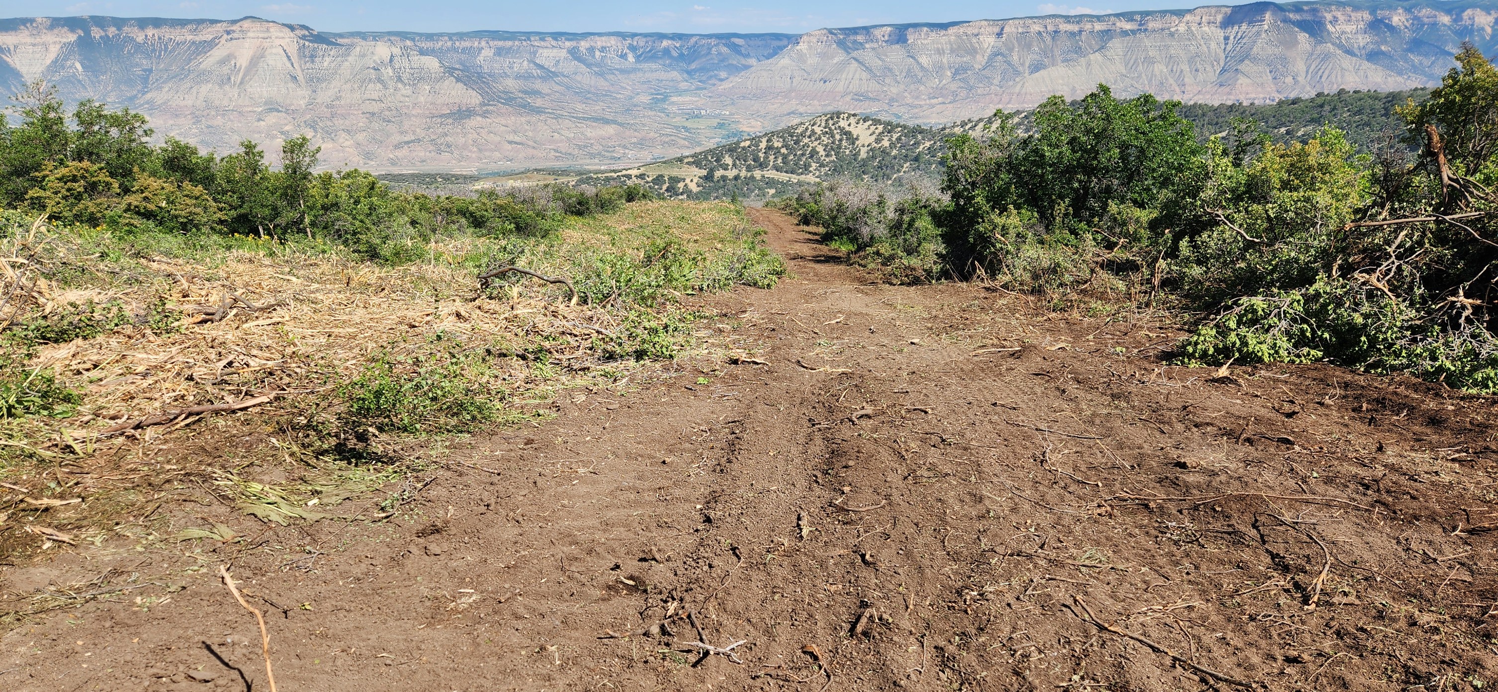
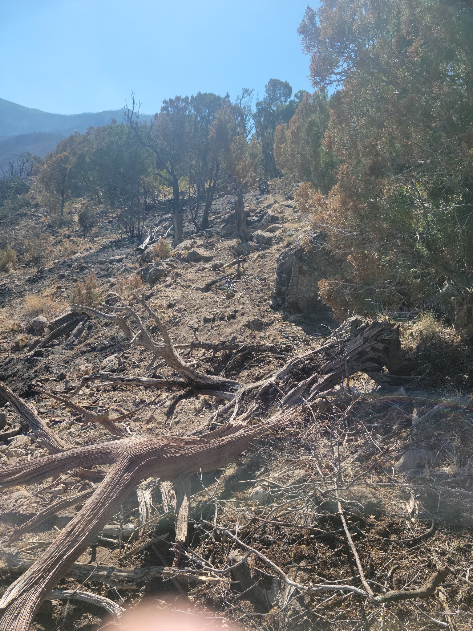
At this stage in the fire, we are transitioning portions of the fire from active suppression and mop-up, to repair in the areas where there have been disturbances of the ground created by either heavy use by vehicles, hand tools or heavy equipment. It is important that we conduct these activities while we have the resources available to do the work.
Suppression repair consists of returning the disturbed areas, fire lines, staging areas, helipads etc., to as natural a state as is practicable. This is to minimize any future damages due to erosion. The activities that the firefighters perform include the use of hand tools to return hand constructed fire lines to a more natural state. Handlines are repaired by building water bars to direct water runoff from the exposed soil in a more suitable direction so as not to create gullies and pulling back the removed material onto the line. Cup trenches will be constructed in steep sections to direct water runoff. Heavy equipment is used for large disturbances by pulling back the removed natural vegetation over the dozer lines to protect the soil and make it easier for the ground to recover.
Photos attached below show a fire line constructed by a dozer and then the result of suppression repair work of a similar dozer line.
Stockton Hill Fact Sheet for Monday July 10
Related Incident:
Publication Type: News
Today’s Date: 07/09/2023
Start Date: 07/04/2023 Location: 10 mi. N. Kingman Cause: Human-caused, under investigation
Acres: 589 Containment: 80%
Evacuations: None
Structures Damaged: 0 Destroyed: 0
Summary: Work continued within communities on the northeast flank of the fire today to ensure no heat remains within the structures. A flight over the fire yesterday showed no heat within the interior of the fire. Winds are stirring up some ash, but no smoke is being reported. Over the next few days, crews will continue to secure line along the northwest flank and patrol and monitor the fire’s perimeter. Resources are making significant progress with containment efforts. The fire is now 80% contained. One hand crew and three engines remain assigned to the fire.
Resources and Personnel Assigned: 33
Type 2 Hand Crew: 1, Engines: 3
Weather: Hot, dry, and breezy weather. Heat will slowly build through the week into next weekend and winds will slowly weaken.
Twitter: @azstateforestry: https://twitter.com/azstateforestry
Facebook: Arizona Department of Forestry and Fire Management: https://www.facebook.com/arizonaforestry
Media/Public Phone: 602-540-1036
Pilot Fire Fact Sheet for Monday July 10
Related Incident:
Publication Type: News
Today’s Date: 07/10/2023
Start Date: 07/01/2023 Location: 20 mi. E. Wikieup on the O RO Ranch within the Mohon Mountains, Yavapai County
Cause: Human-caused, unknown at this time
Acres: 33,834 Containment: 5%
Evacuations: None Structures Damaged: 0 Destroyed: 0
Summary: The fire grew more than 1,500 acres today as activity increased on the eastern flank after the fire made a run up into SH Hill. This morning the fire started backing down Ledge Canyon east to south, then made its way up into SH Hill driven by the wind, terrain, and grass loading. Aircraft was ordered to slow the fire’s progression and hold it in its place within rocky terrain. Out of safety concerns, crews cannot engage on that side until the fire comes out of that rugged terrain and into flatter ground. Aircraft will continue to be used as needed on that side. Today, crews completed containment line on the northeast side of the fire from Trout Creek toward the northern end of Ledge Canyon. Fire operations report those lines are holding well and are currently being mopped up and monitored. The southwest side of the fire is still hung up in Adobe Creek. Resources are trying to keep the fire out of Francis Creek and are tying containment line in to an existing two-track road. Along the west side, containment lines are stabilized and holding in the winds. Fire activity continues to stay steady along the eastern and southwestern flanks. Overall, the heat within the fire’s interior is decreasing. Hotshot crews, hand crews, engines, aircraft, medic teams, and logistical personnel are supporting the incident. In areas that are unsafe to send in crews, satellite-based mapping and the Department of Forestry and Fire Management’s UAS platform are being used to monitor for heat and a potential increase in activity.
Resources and Personnel Assigned: 162
Type 1 Hand Crew (HC): 2, Type 2-IA HC: 2, Type 2 (HC): 1, Type 3 Helo: 1, Engines: 6, Single Engine Air Tankers: 2
Weather: Hot and dry conditions with breezy southwest winds.
Incident Information:
Arizona Department of Environmental Quality Smoke Forecast: https://www.azdeq.gov/wildfiresmokeforecast?fire=pilotfire
Twitter: @azstateforestry: https://twitter.com/azstateforestry
Facebook: https://www.facebook.com/arizonaforestry
Pass Fire Update for July 9 2023
Related Incident:
Publication Type: News
Pass Fire Update for July 9, 2023
Acres: 59,883
Start Date: May 18, 2023
Location: 40 miles west of Winston, NM
Cause: Lightning
Containment: 55%
Fuels: Timber, piñon/juniper and grass
Personnel: 69, 1 Type 3 Helicopter
Yesterday, the Pass Fire showed a minimal amount of smoke in the Indian Creek area. Acreage on the Pass Fire remains the same and containment is now at 55 percent. Because of hot, dry conditions and expected thunderstorms, firefighters will continue monitoring it to ensure it stays confined to the planned boundaries. Containment will increase as the Pass Fire receives wetting rain.
Today, thunderstorms with a 40 percent chance of rain are expected over the Pass Fire and over other parts of the Gila National Forest. The Wildland Fire Module, a ten-person crew will remain posted at Copperas Peak to monitor the Pass Fire and lookout for any new starts throughout the day. Firefighters posted at Trails End will be released today if no activity ensues by end of shift. The Type 3 Helicopter will be available for reconnaissance flights.
The Pass fire is transitioning from a Type 3 Incident Management Team to a smaller Type 4 organization by 6:00 PM today.
The Gila National Forest is a fire-adapted ecosystem that is dependent on low intensity fire to enhance forest conditions. Fire managers took advantage of the unseasonably cool and wet conditions in the spring to manage the natural lightning-caused Pass Fire, allowing it to play its role in removing hazardous fuels, promote healthy vegetation and improve forest health.
Weather: 40 percent chance of thunderstorms and for wetting rain today in the afternoon with a better chance on Monday. Temperatures in the 90’s with 10 mph west winds becoming southwest by afternoon and erratic gusts due to thunderstorms.
Aviation Restrictions: A Temporary Flight Restriction (TFR) is still in place over the Pass Fire. All non-fire aircraft are restricted. This includes civilian drones. Unauthorized aircraft in the area will ground firefighting aircraft, hindering firefighting efforts. If you fly, we can’t. type
For More Information:
- Inciweb: https://inciweb.wildfire.gov/incident-information/nmgnf-pass-fire
- New Mexico Fire Information: https://nmfireinfo.com/
- Air Quality: https://www.airnow.gov
Pass Fire Update for July 8 2023
Related Incident:
Publication Type: News
Pass Fire Update for July 8, 2023
Acres: 59,883
Start Date: May 18, 2023
Location: 40 miles west of Winston, NM
Cause: Lightning
Containment: 50%
Fuels: Timber, piñon/juniper and grass
Personnel: 69, 1 Type 3 Helicopter
Yesterday, firefighters completed the final work on rehabilitation of areas impacted during the management of the Pass Fire along with the removal of equipment and supplies used to protect values at risk. Today, a couple of fire crews will be posted as lookouts, a Hotshot crew will be at Trail Ends Ranch to monitor and patrol the southeastern edge of the perimeter and a Wildland Fire Module crew will be posted at Copperas Peak to monitor any smokes from the Pass Fire from that vantage point, while keeping an eye out for new wildfire starts.
More accurate mapping has set the Pass Fire acreage at 59,883 and containment is now at 50 percent. Fire managers are working to transition the Pass Fire back to the district level possibly by Monday.
Closure Order 03-06-02-23-006 for the Pass fire has been lifted as of this morning. Trails and roads related to this order are now open to the public. Some smoldering of fuels may still exist within the interior of the Pass Fire perimeter. The Pass Fire is being managed to improved forest health and for the protection of values at risk including private property near forest lands. Please continue to be safety conscious while visiting the Gila National Forest.
Weather: Partly cloudy with temperatures in the 90’s. West winds at 7-9 mph. A chance of thunderstorms in the afternoon may cause gusty winds.
Aviation Restrictions: A Temporary Flight Restriction (TFR) is still in place over the Pass Fire. All non-fire aircraft are restricted. This includes civilian drones. Unauthorized aircraft in the area will ground firefighting aircraft, hindering firefighting efforts. If you fly, we can’t. type
For More Information:
- Inciweb: https://inciweb.wildfire.gov/incident-information/nmgnf-pass-fire
- New Mexico Fire Information: https://nmfireinfo.com/
- Air Quality: https://www.airnow.gov
Pika Fire News Release
Related Incident: Pika Fire
Publication Type: News
Fire Update
July 12th, 2023
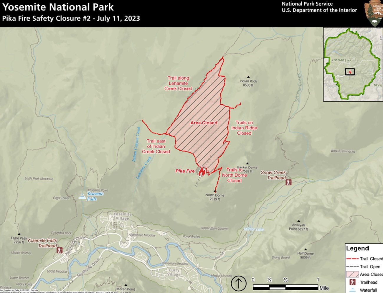
PIKA FIRE
Location: Just west of North Dome
Elevation: 7,100’
Discover date: June 29, 2023
Size: 40 acres
Cause: Lightning
Yosemite Fire crews are using a confine and contain strategy utilizing natural barriers and trails. The fire has slow growth, with some isolated active pockets northwest of North Dome.
A confine and contain strategy under favorable conditions allows fire to move naturally across the landscape, providing ecological benefits to plants and wildlife, while also meeting protection objectives to minimize risk to people and infrastructure.
Trail closures went into effect Tuesday evening, impacting short sections of the North Dome Trail and Lehamite Creek Trail. A trail closure map can be seen HERE.
Smoke impacts from the Pika Fire are expected to impact Yosemite Valley in the evening and overnight with conditions improving as smoke lifts during the afternoons. Impacts may also be seen in the surrounding communities of Groveland, El Portal, and Lee Vining. To monitor smoke in your area and take precautions for your health, please visit Current Air Quality and Smoke Monitoring - Yosemite National Park (U.S. National Park Service) (nps.gov)
Flying V Fire Update July 10 2023
Related Incident: Flying V Fire
Publication Type: News
Flying V Fire: July 10, 2023
Location of Origin: Highway 60 at mm 300
Start Date: July 5, 2023
Size: 831 acres
Cause: Undetermined
Percent Contained: 17
Personnel: 248
Fuels: Pinyon-Juniper, Grass
Resources Assigned: 8 crews, 5 engines, 2 water tenders, 2 helicopters, 2 Dozers
Operations: Fire activity is minimal, with only a few areas that remain active. Due to the hard work of firefighting resources, the perimeter has not changed in recent days and suppression lines are expected to hold today with no expected increase in size.
Closures:
- The Incident Management Team and ADOT have formalized a conditional reopening plan for highway 60. The closure that has been in effect on highway 60 has been modified to allow for traffic easement between 9:00 pm – 6:00 am with reduced speeds. Traffic will be escorted via pilot car tomorrow from 6:00 am – 9:00 pm and will be reduced to one lane. The public is advised to allow for traffic delays during this time. This conditional reopening plan may be rescinded if fire activity increases in the area.
- The White Mountain Apache Tribe issued an executive order on July 7, 2023. There are no campfires allowed at the lakes, streams, or even in the community, and no yard burning. Wood cutting must be done before 10:00 a.m., and there is no wood cutting in the closure area.
Weather: Today’s forecast is calling for mostly sunny skies with a high of 97 degrees and winds from 5 to 10 mph.
Values at risk: Emory Oak grove in the area of Flying V, tribal sensitive species in surrounding areas, cattle and grazing areas, watershed and riparian areas, woodland areas, the Salt River recreation areas, the Highway 60 transportation corridor, communications towers on Brewer Hill, Cibecue Ridge, and north of Salt River Canyon.
Safety: Wildfire smoke may impact Cibecue, White River, Carrizo, Cedar Creek, and the White Mountain communities. The public is encouraged to take precautionary measures.
Official fire information can be found on these sites:
- Inciweb: https://inciweb.wildfire.gov/incident-information/azwat-flying-v-fire
- Facebook: https://www.facebook.com/BIAFAAFireMgt
- ADEQ Air Quality Information: https://azdeq.gov/node/7077
- ADOT: https://www.az511.com/
- Executive Order: Stage 2 Fire Restrictions and Forest Closures