
Ridge Creek Fire Update for August 19 2023
Related Incident:
Publication Type: News
Ridge Creek Fire
Idaho Panhandle National Forests, Coeur d’Alene River Ranger District
Fire Information: 208-953-7022
Media Information: 989-292-9373
2023.ridgecreek@firenet.gov
https://inciweb.nwcg.gov/incident-information/idipf-ridge-creek
August 19, 2023
Location: Approximately 3.5 miles east of the north tip of Hayden Lake, along the Hayden Creek Road (FSR 437) in the Ridge Creek drainage.
Start Date: 8/3/2023 Cause: Human/Under Investigation Size: 4,020 acres Containment: 12% Total Personnel: 521 Engines: 20 Heavy Equipment: 6 Crews: 12
A community meeting for the public is planned for 3:00 PM this Sunday afternoon, August 20, at the Athol Community Center, 30355 3rd St., Athol, ID 83801. The meeting will be live-streamed on the Idaho Panhandle NF Facebook Page: https://www.facebook.com/USFSIPNF/ Structure protection staff will be placing water-handling equipment in the Bunco and Trapper Creek areas as a precautionary measure. The Kootenai County Office of Emergency Management has issued a notice for residents in the Bunco area, changing their Ready, Set, Go Status to ‘Set’. A revised Ready, Set, Go map is enclosed with this update. Weather will moderate today, giving fire crews and aviation resources greater opportunity to engage the Ridge Creek Fire.
FIRE STATUS
Despite challenging conditions over the last few days, crews were able to hold and strengthen firelines on the Ridge Creek Fire, particularly along the southern and western flanks of the fire. As anticipated, with strong southwest winds, the fire moved to the northeast resulting in the increased acreage reported today. The size of the fire is currently estimated at 4,020 acres and 12% containment, which is reflected on the enclosed maps. Crews will continue to hold and strengthen existing containment lines on the western, southern, and eastern perimeters. Crews will continue to use firing operations, particularly at night, to improve and widen containment lines by burning away shrub and surface layer fuels.
With diminished winds today, as compared to yesterday, conditions for the use of aircraft will be improved. As visibility improves, aircraft will be observable, particularly over the northeast area of the fire. Aviation assets continue to be prioritized regionally and nationally based on values at risk.
A night shift of engines will continue to be used to patrol west, south, and east perimeters to monitor fire behavior. Smoke from the Ridge Creek Fire, and smoke from fires to the west and north of the Hayden Lake area, including fires in Canada, will likely remain visible into the afternoon.
WEATHER AND FIRE BEHAVIOR
Weather will moderate noticeably today. This should serve to moderate fire behavior. Temperatures will approach 80 degrees; minimum relative humidity will remain low, varying between 16-20%. Overnight humidity recovery will be poor, reaching approximately 36%. Low relative humidity with moderate winds and temperature may still produce active fire behavior in portions of the fire and smoke is likely to be visible. Air quality information is available at www.airnow.gov and www.wildlandfiresmoke.net. Winds will be light at 8 mph, gusting to approximately 18 mph. Winds will shift and flow out of the northeast, which will tend to move the fire back into its existing footprint where extensive efforts have been made to strengthen containment lines.
EVACUATION STATUS
The Kootenai County Office of Emergency Management has issued an alert to inform residents of the identification of READY, SET, GO areas in the vicinity of the Bunco Road and Hayden Lake. Status for residents in the Bunco Road area has been change to ‘SET’ and the ‘READY’ area has been expanded. In ‘SET’ status, residents are directed to be prepared for an evacuation if notified.
The Kootenai Office of Emergency Management provides the following direction for residents in areas designated with a SET status: “you are alert to the Ridge Creek Fire in your area, that you are packed to leave and prepared to leave at a moment’s notice if you must evacuate. If you have livestock or special circumstances you have begun to take the necessary steps to address these concerns and made arrangements to relocate livestock if necessary.”
A map of the revised READY, SET, GO areas is included with this update. All residents should be familiar with evacuation procedures and consistently adhere to good fire prevention measures. More information is available at https://www.kcsheriff.com/186/Emergency-Management”
CLOSURES AND SPECIAL MESSAGES
There is a 24-hour per day Temporary Flight Restriction (TFR) in place for the Ridge Creek Fire to prevent incursion of civilian aircraft into the area used by fire-fighting aircraft. This restriction also applies to the use of drones in the TFR area.
Firefighting aircraft are shared resources among numerous fires within the region, including the Ridge Creek Fire. These aircraft will continue to use area waterways, including Hayden Lake, for fire suppression efforts. This means that residents and recreational boaters are likely to see either helicopters or fixed-wing aircraft using the lake. For planes in particular, this requires a long, linear approach and exit from the lake. This restricts their ability to maneuver abruptly should watercraft be within their flight path, creating a serious safety hazard for both boaters and pilots.
The Ridge Creek Fire has a substantial fleet of aircraft available to support ground operations. Expect to see both fixed-wing aircraft and helicopters working, particularly on the northeast area of the fire. Again, if you are a recreational boater and you observe aircraft using either Lake Hayden or Lake Pend Oreille, you should restrict your activities to the shore area of the lakes.
The Coeur d’ Alene Dispatch Zone has issued Stage II Fire Restrictions for the Idaho panhandle. All of Kootenai County is within the Stage II Fire Restrictions area. See the flyer included with this update.
The Idaho Panhandle National Forests issued an emergency closure (Closure Order #01-04-03-23-002) effective August 4, 2023. This Order is for public and firefighter safety due to heavy fire traffic on the area impacted on the Coeur d’Alene River Ranger District, and prohibits all methods of travel (foot, mechanized, motorized and stock) on Forest Service Roads 392, 428A, 437, 1511, 1530, 1552, 1587 and Forest Service Roads 206 and 406 north of their junction, Forest Service Trails 69, 78, 234, and 802 as well as within the described area.
Fire Update Elkhorn Fire August 19 2023
Related Incident: Elkhorn Fire
Publication Type: News
McCall, Idaho – The Elkhorn Fire remains 26,048 acres and 45% complete. Today will be warmer with the chance of showers increasing into the evening. A major weather change will begin on Sunday when the first surge of tropical moisture moves north into our region. Potential heavy rainfall from moisture associated with Hurricane Hilary could increase risk of flooding, rock and mudslides, and debris flows. Heavy rainfall (over an inch) is expected Sunday through Tuesday. Steep terrain combined with a severe burn scar and precipitation can result in flash flooding within minutes of precipitation beginning. For weather updates visit the National Weather Service Missoula Forecast Office https://www.weather.gov/mso/. Learn how to prepare at https://www.ready.gov/floods.
There is a detour on the Divide Trail #505 while firefighters and heavy equipment are working from 8:00 a.m. to 8:00 p.m., in this area. They will be removing merchantable logs to landing piles, masticating debris, and beginning implementation of waterbars. The alternate route is from the junction of the Divide Trail #505 and Forest Road 468, west to Forest Road 1172, northeast to the Red River Road #234, then southeast on Forest Road 1170 to Forest Road 1170C to the junction of Forest Road 1170C and the Divide Trail #505. Fire personnel will also be using boats, helicopters, and vehicles to backhaul structural protection equipment no longer needed from Whitewater Ranch downriver to China Bar.
Communication continues with the boaters entering the river at Corn Creek and again at Hancock Rapids before entering the fire footprint along the river corridor. Boaters are required to stop at Hancock Campsite on river-left, at river mile 26.1 to receive further instruction via a river information board regarding passing through and camping in the area of the Elkhorn Fire. Please read the river information board for any changes that may have occurred since you left Corn Creek launch. Camping, recreating (i.e., picnic, bathroom breaks and beach walking) and stopping through the area of Elkhorn fire activity is allowed with some exceptions. Once past Hancock Camp (River Mile 26.1) there is no stopping until boaters pass Magpie Creek Camp (River Mile 29.6). After passing Magpie Creek Camp, boaters will be allowed to camp and recreate on a First Come, First Served basis everywhere except: Upper Allison, Allison, Lower Allison, Whitewater Camp. After passing Whitewater Ranch (River Mile 39) there are no restrictions connected to the Elkhorn Fire. For additional information on rafting, contact the river desk at 208-756-5587 or 208-481-2625.
The U.S. Forest Service Nez Perce-Clearwater and Payette National Forests issued the Elkhorn fire area, roads and trails closure order #01-17-05-23-003, https://www.fs.usda.gov/alerts/nezperceclearwater/alerts-notices/?aid=82169 that spans both sides of the Salmon River but excludes the Salmon River Wild and Scenic Corridor below the high-water line.
A Temporary Flight Restriction (TFR) is in place for a two-mile buffer around the fire perimeter. All aircraft (including drones) not assigned to the fire are required to remain out of the TFR area between 0900-2100.
Fire info and daily air quality updates are available on InciWeb https://inciweb.nwcg.gov/incident-information/idpaf-elkhorn-fire and the Payette National Forest Facebook https://www.facebook.com/payettenationalforest.
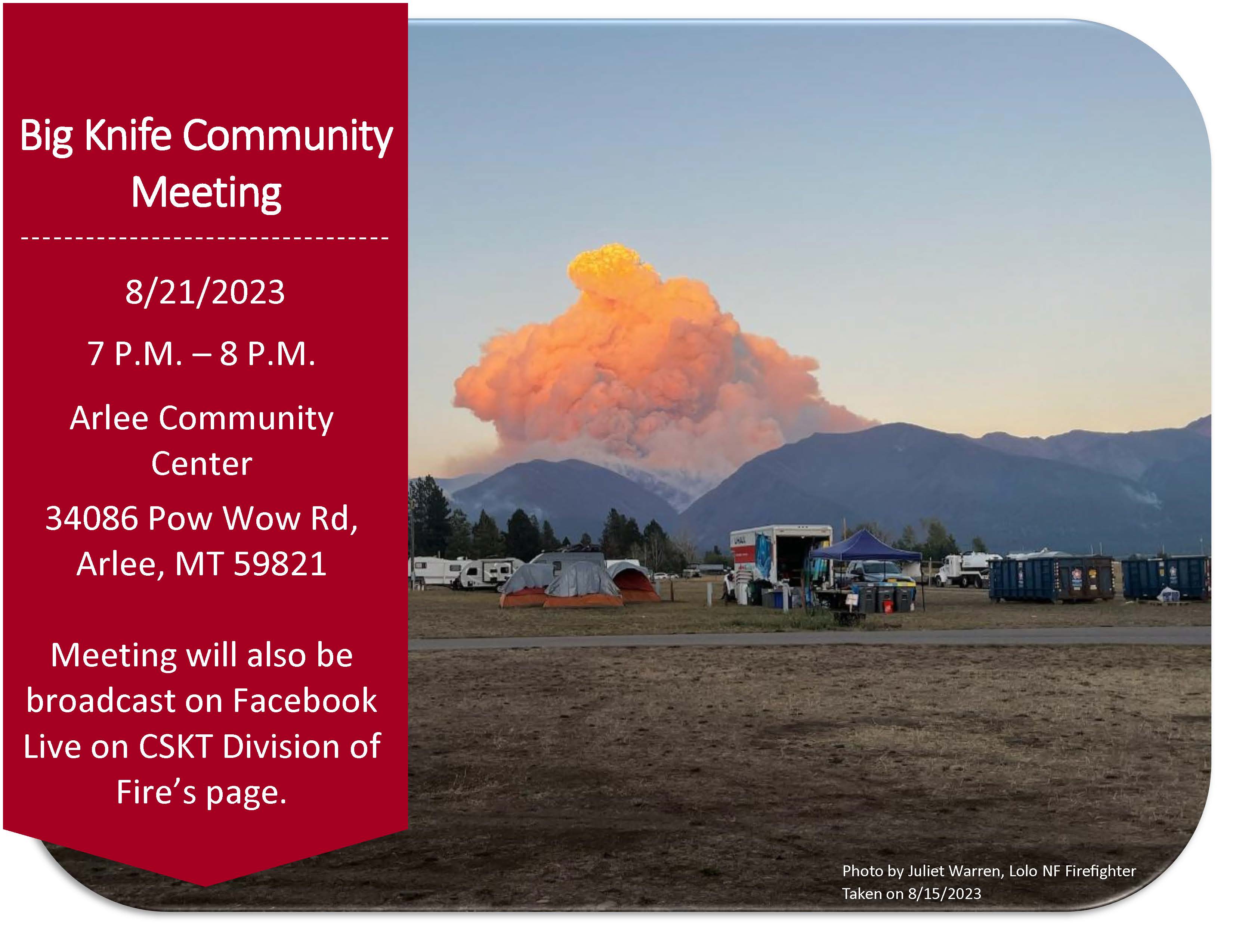
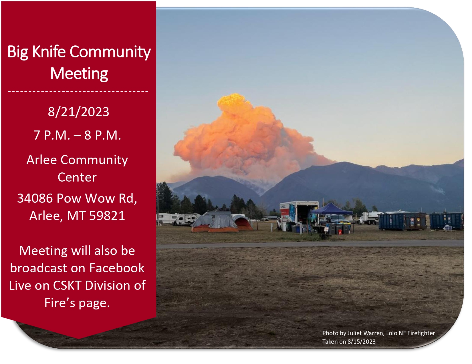
Community Meeting August 21
Related Incident: Big Knife
Publication Type: Announcement
Big Knife Fire Community Meeting at the Arlee Community Center at 34086 Pow Wow Rd., Arlee, MT on Monday, August 21 at 7:00 PM.
![]()

August 19 2023 Daily Update
Related Incident:
Publication Type: News
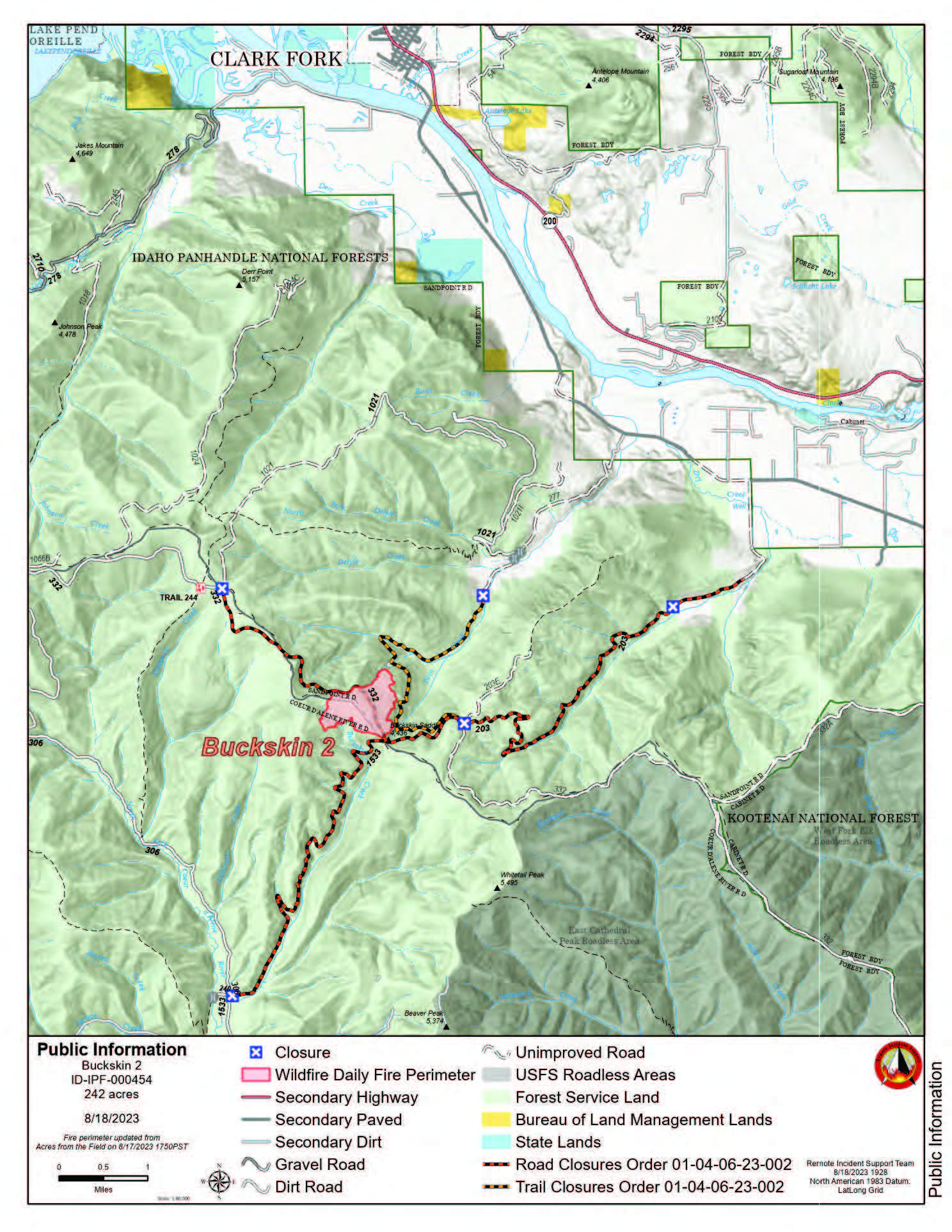
Buckskin 2 Fire - August 19, 2023
Idaho Panhandle National Forests, Sandpoint Ranger District
Fire Information: 208-557-8813
https://inciweb.nwcg.gov/incident-information/idipf-buckskin-2-fire
Type 3 Incident Commander, Brian Hicks
Location: Located approximately 8 miles due south of Clark Fork, ID on the upper end of Twin Creek and Buckskin Saddle, south of Highway 200
Start Date: 8/4/2023 Cause: Undetermined Size: 242 acres Containment: 55% Total Personnel: 171 Engines: 8 Hand Crews: 4 Modules: 2
Heavy Equipment: 3 Dozers, 2 Skidgens, 1 Water Tender
Thanks to all the hardworking firefighters and despite the week of challenging weather, fire managers have been able to increase containment to 55%. There has been no growth on the fire in several days. Fire behavior within the interior has become minimal, with some backing, flanking, and occasional tree torching. As the winds continue to test the fire lines through the weekend, firefighters will remain focused on gridding and monitoring for any possible new spot fires over the line. Crews and heavy equipment are increasing the depth while extinguishing any hotspots near the existing firelines. Engine crews have completed the structure protection assessments in the Twin Creek and Rearden Road areas. The fire remains 1.8 miles from the nearest structure.
Until a season-ending event occurs, smoke may be visible from pockets of unburned fuels within the perimeter of the fire. The smoke that has settled into the area is from existing and new large fires in Washington and British Columbia. See https://fire.airnow.gov/ for more detailed smoke information.
The locations where these fire updates were being posted, in and near Fork Clark, will no longer be updated daily. In lieu of the update, a poster with QR codes has been placed. The QR codes are direct links to the updates on INCIWEB, Facebook, and the Smoke Forecast. The published email and phone number will still be monitored.
EVACUATION STATUS
The Bonner County Sheriff’s Office issued a READY notification for the Twin Creek Rd and Rearden Rd residents in Clark Fork. To receive local status updates, sign up for Bonner County Sheriff’s Office emergency messaging through NIXLE at www.nixle.com.
CLOSURES AND SPECIAL MESSAGES
Forest Closure Order is in effect for roads associated with the Buckskin Fire; the intersection of Forest Service Roads 203 and 332, the intersection of FSR 1021 and 332, and 1533 and 306 in Clark Fork. UTV trail 77 is closed as well. An extension of the FSR 203 closure, extending to the edge of private land, took effect on 8/15 at 0700. The public is prohibited from the general area for firefighter safety and asked to practice caution while driving near firefighters and apparatuses.
Stage II Fire Restrictions are in effect. To view the Idaho Fire Restrictions Plan and a statewide map with current information regarding fire restrictions, please visit https://www.idl.idaho.gov/fire-management/fire-restrictions-finder.
A Temporary Flight Restriction is in place for the safety of our aerial resources and firefighters on the ground. This includes drones; please do not fly drones in the fire vicinity. If you fly, we can't.
WEATHER
Sunny, with a high near 89. Windy, with a west wind around 25 mph, with gusts as high as 37 mph.
***Dry Cold Front with Stronger Winds This Evening***
Winds will generally be light and terrain driven. RH Recoveries will be poor at the fire. Shower and thunderstorm chances increase Sunday afternoon and stay elevated through Tuesday.
Settings - change map background and toggle additional layers
Filter - control incident types displayed on map.
Zoom to your location
Reset map zoom and position
Could not determine your location.
Show Legend
 Wildfire
 Prescribed Fire
 Burned Area
Response
Burned Area
Response Other
Other
South Fork Complex
Unit Information
Incident Contacts
Big Knife Fire Update August 19 2023
Related Incident: Big Knife
Publication Type: News
A community meeting with updates on the Big Knife Fire will be held at the Arlee Community Center at 34086 Pow Wow Rd., Arlee, MT on Monday, August 21st, 2023 at 7 P.M.
With temperatures and wind speeds moderated by heavy cloud cover, fire activity was milder than predicted. On the north edge of the fire, along S. Canal Road, crews are continuing to mitigate hazards by removing snags inside the fire perimeter at least a tree length from the line. Crews patrolling the area observed the fire backing down into the bottom of the Gold Creek drainage. On the south end of the fire in the Agency Creek drainage, crews are continuing to patrol and monitor fire activity. On the east side of the fire near Jocko Lookout, crews will continue monitoring the pumps and sprinkler systems and monitoring the fire growth in the primitive area.
The Big Knife Fire is currently 1.25 miles north of the Rattlesnake Wilderness Boundary (Lolo National Forest) with no significant growth towards the Lolo National Forest in the last week. Smoke from the fire may impact the Snowbowl area, however the Lolo National Forest does not have any forest closures in place on the Missoula Ranger District.
CLOSURES AND SPECIAL MESSAGES: Several areas near the base of the mountains west of the Big Knife Fire remain in PRE-EVACUATION WARNING by order of the Lake County Sheriff. See the map for those locations in yellow (Jocko, Canal, Francis). The Tribal Primitive Area, Belmore Slough and Burnt Cabin Roads are closed.
A PRE-EVACUATION WARNING means you may be in your home. Individuals in this status should not bring back evacuated livestock until the area is downgraded to READY status.
A temporary flight restriction (TFR) is in effect around the fire area. Do not fly unmanned aircraft (drones) near the fire areas.
Weather: Temperatures will remain cooler with highs in the 70s and 80s on Saturday, with only a slight chance of rainfall. Remnants of Hurricane Hilary are expected to arrive late Saturday night, with the heaviest rains on Monday and Tuesday. Up to 1.5 inches are possible, while 0.50 to 0.75 is more likely.
FIRE RESTRICTIONS: Stage 2 fire restrictions are in place across the Flathead Indian Reservation. No campfires are allowed, no smoking outside of vehicles, no operating combustible engines from 1 p.m. to 1 a.m., no operating vehicles off designated roads and trails. Stage 1 fire restrictions are in place in Granite County. The following are prohibited until rescinded: Building, maintaining, attending, or using a fire or campfire except within a developed recreation site or improved site. Smoking, except within an enclosed vehicle or building, a developed recreation site or while stopped in an area at least three feet in diameter that is barren or cleared of all flammable materials. Visit https://www.mtfireinfo.org/ for more fire restriction information across Montana.
Anderson Complex Daily Update for Saturday Aug 19 2023
Related Incident: Anderson Complex
Publication Type: News
ANDERSON COMPLEX DAILY FIRE UPDATE | Saturday, Aug. 19, 2023
![]()
Anderson Complex Fire Information
Phone: (907) 921-2553 (8 a.m. to 8 p.m.)
Email: 2023.andersoncomplex@firenet.gov
Evacuations downgraded; command of Anderson Complex to change hands
The Teklanika River and all residents along the Teklanika River have been moved from evacuation status GO to evacuation status SET. Individuals in this area should be set to leave at a moment’s notice.
All other residents, including those in the City of Anderson, North Forties, Kobe Ag, Rose Hip Creek and Clear Sky Homestead, have been released from evacuation status. Residents should remain alert and informed. If you encounter firefighters working in these areas, please give them space.
Individuals re-entering burned areas should be aware of possible hazards, including fire-damaged trees, ash pits, smoldering stumps or logs, and the potential for flash flooding. Areas impacted by the Birch Creek Fire (#285) have experienced flooding in recent days. Roads in the Rose Hip Creek area may be impassable due to water.
Visit the Denali Borough website for additional information.
FIRE UPDATE: This is the final update for Great Basin Team 3. The team will transfer command of the Anderson Complex to a Type 3 organization on Sunday, Aug. 20, at 8 a.m. Incident command will move from Anderson to Nenana to better support firefighters working on the Teklanika River Fire (#257) and Shores Landing Fire (#325). Both fires still have the potential to threaten structures and allotments.
Over the past three weeks, crews have ended the threat to 80 percent of the structures that were initially endangered by fires in the Anderson Complex. Cooler, wetter weather has also significantly reduced fire activity. Firefighters continue to remove pumps, hoses and other equipment from areas where they are no longer needed. The equipment is being brought to the incident helibase at the Nenana Airport before being returned to the interagency fire cache in Fairbanks.
Firefighters are still extinguishing hotspots and felling fire-damaged trees in some areas as part of a post-fire process known as mop-up. Suppression repair work is complete in the North Forties and Kobe Ag subdivisions. Roads in the area have been graded.
A contingent of firefighters assigned to the Anderson Complex remain ready to respond to any new fires in the area.
The Anderson Complex includes the Teklanika River Fire (#257), Birch Creek Fire (#285), Shores Landing Fire (#325), Rock Creek Fire (#287), Bear Creek Fire (#287), Kobe Road Fire (#297), Nenana River Fire (#288), and Nenana River 2 Fire (#289). The fires have a combined acreage of 58,933 acres.
WEATHER: Scattered showers are expected again today. Winds will still be from the southwest with gusts up to 18 mph. The high temperature should be in the low 60s. Widespread rain showers are in the forecast beginning Sunday.
August 19 2023 Daily Update
Related Incident:
Publication Type: News
Yesterday the area experience higher relative humidities and cloud cover that assisted firefighters in their efforts to contain the East Fire. The weather did bring with it some winds that created spot fires and growth in acreage. The main growth of the fire occurred downslope towards the Middle Fork River and south towards the East Fork Clear Creek. Air resources worked throughout the day to drop retardant on the upper slopes and scooper planes dropped water in the areas near the streams.
The 11 hand crews currently on scene are spread out along the western edge of the fire from the repeater site to Forest Road 405. Work includes digging containment line, improving road access, and falling snags or trees that could fall across the line.
Today the Great Basin Type 2 Incident Management Team will access the fire area, and work alongside the current fire managers on the ground to gain knowledge. The Incident Command Post will be located south of Cabarton road, so expect fire traffic travel across Highway 55 and in that area.
Values threated include the East Mountain repeater site, timber sales, trail systems, and private timber lands.
Weather: Isolated showers and thunderstorms are expected after noon with areas of smoke. High temperatures are expected to be around 82 with calm winds. Chance of precipitation is 20%
Closure Area: expected to be issued later today.
Air Quality: http://idsmoke.blogspot.com/
Thompson Ridge Fire Update Aug 19 2023
Related Incident: Thompson Ridge Fire
Publication Type: News
Thompson Ridge Fire Update
Saturday, August, 19, 2023
FIRE SITUATION
With a few days of strong work through difficult conditions, the firefighters on the Thompson Ridge Fire have achieved 60% containment.
Moderate and sporadic rain continues to fall. During the day, before the storms impacted the area, crews were able to seek out remaining heat sources around much of the perimeter. The Unmanned Aircraft System (UAS) assisted firefighters in this process by identifying the heat sources so crews could mop up any hot spots that threatened the line. The UAS was then released after recon flights were completed to detect these heat signatures.
With the current weather, increased fuel moisture, and high humidity, there is little threat to the fire perimeter. Firefighters will continue to work the remaining uncontained portions of the fire’s edge and monitor and patrol the fire area. Potential for growth is low, but fire managers want to ensure as much containment as possible during this period of moderate fire behavior.
As storms continue to impact the area, firefighters are pulled from the fireline as needed to avoid any injury and minimize danger. The predicted rain will continue to impact suppression efforts, as it creates unsafe conditions to work in. Firefighter safety remains the number one priority.
EVACUATIONS: None at this time.
CLOSURES: Please refer to closure order. Please note that SR-153, Kent’s Lake Road (137), Upper and Lower Kent’s Lake, Little Res. Campground, Anderson Meadow, and LeBaron remain open at this time. Use caution in and around these areas, as you will see an influx of both ground and aviation equipment working to suppress the fire.
STATUS
Start Date: August 4, 2023
Incident Type: Wildfire
Size: 7,253 acres
Cause: Lightning
Containment: 60%
Location: 10 miles southeast of Beaver, Utah
Terrain: Steep, rugged terrain in remote areas transitioning to rolling pinyon juniper hills
Structures Threatened: None
RESOURCES
Engines: 12
Water Tenders: 1
Crews: 7
Helicopters: 5
Dozers: 1
Total Personnel: 398
August 19 2023 Colt Fire Daily Update
Related Incident:
Publication Type: News
NORTHERN ROCKIES TEAM 5 INCIDENT COMMANDER: JOE SAMPSON
CURRENT STATUS
Firefighters are taking advantage of limited fire activity to patrol and mop up hot spots. Chipping operations continue on the southern and eastern edges. The TFR will still be in effect 24 hours a day due to continued night operations with the unmanned aerial system conducting infrared flights looking for areas of heat along the fire’s perimeter. The ceiling is 9,500 feet.
PLANNED ACTION
Command of the fire will transfer from Northern Rockies Complex Incident Management Team 5 to Wyoming Team 4 Type 3 team at 8:00 pm today. Crews will continue to mop-up residual heat along the fire’s perimeter. The majority of the fire’s heat remains on the fire’s southwestern edge. Chipping operations will continue on the southern and eastern perimeters. Unmanned Aerial Surveillance flights will continue to assist firefighters searching for heat along the fire’s perimeter.
WEATHER AND FIRE BEHAVIOR
Temperatures will be moderate over the weekend with precipitation possible on Sunday. Tropical moisture from Hurricane Hilary is expected to make its way into the area in the beginning of next week. Heavy downed fuels will continue to smolder but fire activity is anticipated to be low.
CLOSURES AND EVACUATIONS
The Lolo National Forests has lifted the closure of the following: Rainy Lake Campground and access road, Alva Lake Campground and access road, as well as Lakeside Campground and access road. All other Forest closures remain in place.