
Rangeland Management on a Burned Area Emergency Response
Related Incident: 2023 - York Fire Burned Area Emergency Response (BAER)
Publication Type: News
Meet Erin, a Rangeland Management Specialist with the Bureau of Land Management. She is supporting the York Fire Burned Area Emergency Response (BAER) by assessing rangeland infrastructure damage and vegetation impacts in the fire footprint.
Mojave National Preserve protects historic grazing infrastructure including fences, corrals, and water developments. Though there is no active grazing in the York Fire footprint, these artifacts have been part of the area’s history since the early 1900s. Rangeland Improvement Projects (RIPs) build infrastructure that facilitates the control of livestock movement and water usage. After a fire, damaged infrastructure must be repaired or replaced. Native rangeland plants, which are important food sources for wildlife and livestock, are often displaced by non-native plants, which thrive with less competition after a fire.
Erin spent the first few days of this assignment in the York Fire footprint. She documented the effect of the fire on native plants, collected samples to assess burn soil severity, and recorded infrastructure damage. After her field assessment, she began the report-writing phase. The last several days of the assignment were spent writing recommendations for replacement, repairs, invasive plant treatments, and native seeding projects. She has also researched these treatment costs.
Fires can be devastating, but these are temporary changes to landscapes that are hundreds of years old. Erin encourages the public to research the role that wildfire plays in their ecosystem and to make their homes defensible. Her work provides land managers with tools that can give native plants the upper hand and jumpstart the recovery process.
While the chance for an adult Joshua tree to live and resprout is slim, Erin observed several root sprouts from dead adult Joshua trees in the Dome Fire footprint. She hopes that the York Fire will experience a similar recovery.
Bowles Creek Fire Update August 19 2023
Related Incident: Bowles Creek Fire
Publication Type: News
Management of the Bowles Creek Fire will transition to Nevada Type 3 Incident Management Team tomorrow, August 20, 2023.
The Bowles Creek Fire is currently at 6,847 acres. A red flag warning was in place yesterday. Fire activity was expected to increase. The area received up to a third of an inch of rain limiting fire activity. Fire activity will increase in the coming days. Fire crews will continue to monitor fire activity. Motorists traveling on Hwy 38, Skalkaho Road, are urged to drive with caution as firefighters will be present along the roadway as they continue fire operations.
Precipitation reduced significant activity. Lower temperatures and higher humidities are expected through the weekend and into Monday, fire crews continue to construct fuel breaks along several roads and other values at risk. Fire officials continue to monitor fire spread and fire behavior as weather conditions change. Firefighters are utilizing firing operations to strengthen containment lines. Fire crews increased road patrols to better monitor spotting and spreading.
Lookout Fire Morning Update 8192023
Related Incident: Lookout Fire
Publication Type: Announcement
Lookout Fire
August 19, 2023
Morning Update
Size: 8,609 acres
Start Date: August 5, 2023
Point of origin: 3 miles North of
McKenzie Bridge, OR
Cause: Lightning
Total personnel: 907
Resources: 46 engines l 19 crews l 10 bulldozers l 16 water tenders l 4 masticators l 7 helicopters
OSFM Resources: 7 task forces
Current Situation: A shift in weather will cause an increase in fire activity today. A red flag warning is in effect
for hot and dry conditions. The most active part of the fire will be in the north and north east today. Internal
burning is occurring where there are pockets of unburned vegetation within the fire perimeter. To date, no
structures have been lost on the Lookout Fire.
Oregon State Fire Marshal (OSFM) task forces continued to establish and improve defensible space
throughout evacuation zones. Day shift crews made headway on structural preparation to the east of Rainbow along Highway 126, including Belknap Hot Springs. Last night, crews completed tactical patrols, working to hold the fire line and ensured a presence around structures.
Today’s activities: Crews will be ensuring lines hold with the weather shift. Firefighters are continuing
preparation on the 2633 Road in the west to use as a control line. Where conditions allow, firefighters will use strategic firing operations to strengthen fire lines. Firefighters are working on the 1508 Road using heavy machinery to remove vegetation which helps prevent fire spread. A mobile retardant base has been set up near Tokatee Golf Course. Retardant drops will be used in key areas to assist crews on the ground in slowing fire activity while they work. Near the north and northeast side of the fire, along the Highway 126 corridor, the seven OSFM task forces will continue preparation work and provide critical infrastructure protection. Night crews will complete tactical patrols and assist wildland resources as needed. A NW Team 6 structure protection group is also working
around Trail Bridge Reservoir.
Evacuation Centers: There is an evacuation center for people and small pets at the Lowell High School for
evacuees from the Bedrock and Lookout Fires. A large animal shelter is set up at the Lane County Fairgrounds in Eugene.
Evacuations: In Lane County, there is a Level 3 (Go Now) evacuation notice for Taylor Rd, North Bank Rd, All areas north of Hwy 126 between Blue River Reservoir Rd. and Drury Ln, the area south of Hwy 126 to the McKenzie River from the east end of McKenzie River Dr. to the McKenzie River Bridge just east of Taylor Rd, Mona Campground, Lookout Campground, H.J. Andrews Headquarters, the area west of Hwy. 126 from Scott Rd. north into Linn County.
There is a Level 2 (Be Set) from Hwy 126 from the Hwy 242 junction to Scott Rd, Paradise Campground, FS Rd. 302, Belknap Springs Rd. S., Belknap Hot Springs Rd, The area east of Hwy. 126 from Scott Rd. north into Linn County.
There is a Level 1 (Be Ready) evacuation notice for areas south of Hwy. 126 from Blue River Reservoir Rd. east to Foley Ridge Rd, McKenzie River Dr, Hwy 242 to FS Rd. 220, Yale Ln., Camp Yale Rd., and FS Rd. 2643 southeast to the 445 spur
For current information please see Lane County’s website at:
https://www.lanecountyor.gov/cms/one.aspx?pageId=19729054
In Linn County, there is a Level 3 (Go Now) for Olallie Campground, Trail Bridge Reservoir & Campground, and the trail systems and roadways north of the Linn County line, and west of Highway 126, extending north to intersection of National Forest Service Road 730 and Highway 126.
A Level 2 (Be Ready) for the area from the east side of Olallie Campground east to the Willamette National
forest boundary, north along boundary to Ice Cap Campground and Trailhead, then west to encompass Lakes End Campground and trail system, and south in line with the intersection of National Forest Service Road 730 and Highway 126 (entrance to the Carmen-Smith Hydroelectric facility). Tamolitch Falls/Blue Pool and Smith Reservoir are within this Level 2 (be set) evacuation zone.
Level 1 (Be Ready) evacuation zone for areas north of Ice Cap Campground, extending east to the Willamette National Forest boundary, and north in line with Highway 20. This includes all areas around Clear Lake, and Clear Lake Campground. For current information please see Linn County’s website at:
https://www.linnsheriff.org/2023/08/lookout-fire-update-august-17-2023-330-p-m/
Weather: Red Flag warning from 11 am Saturday to 9 pm Sunday is in effect due to critical fire weather which includes dry and gusty conditions.
Closures: Highway 242, McKenzie Highway, is closed between milepost 61-76, 14 miles west of Sisters, Oregon to just east of the junction with Highway 126. Highway 126 is currently open. Please monitor Trip check for any updates https://tripcheck.com/.
Willamette National Forest closures can be found at: https://www.fs.usda.gov/detail/willamette/alertsnotices/?cid=fseprd552029
Restrictions: Fire Restrictions are in place on the Willamette National Forest
https://www.fs.usda.gov/willamette
Smoke Outlook: Smoke outlooks for Lookout Fire are available at
https://outlooks.wildlandfiresmoke.net/outlook/4c92bc1a?
Information Line: 541-215-6735 8am-8pm | Email: 2023.lookout@firenet.gov
Facebook: https://www.facebook.com/LookoutFire2023
Inciweb: https://inciweb.nwcg.gov/incident-information/orwif-lookout-fire
Niarada and Mill Pocket update for August 19 2023
Related Incident: Niarada
Publication Type: News
Fire lines built over the past several weeks were tested by intense winds Friday and withstood 30-40 mph gusts. Firefighters were on alert for any blowing embers or new spot fires outside the line while also working to mop up some areas and work on suppression repair in others.
The eastern portion of the Niarada Fire closest to Elmo saw the bulk of the effort as crews worked to cool lingering heat source utilizing some of the 4 miles of hose lays that have been installed in the area. These efforts will be ongoing for the next several days. Structure protection resources – engine crews, sprinkler systems and hose lays – remain in place but will begin drawing down as the weekend forecast calls for reduced wind, increased humidity and cloud cover.

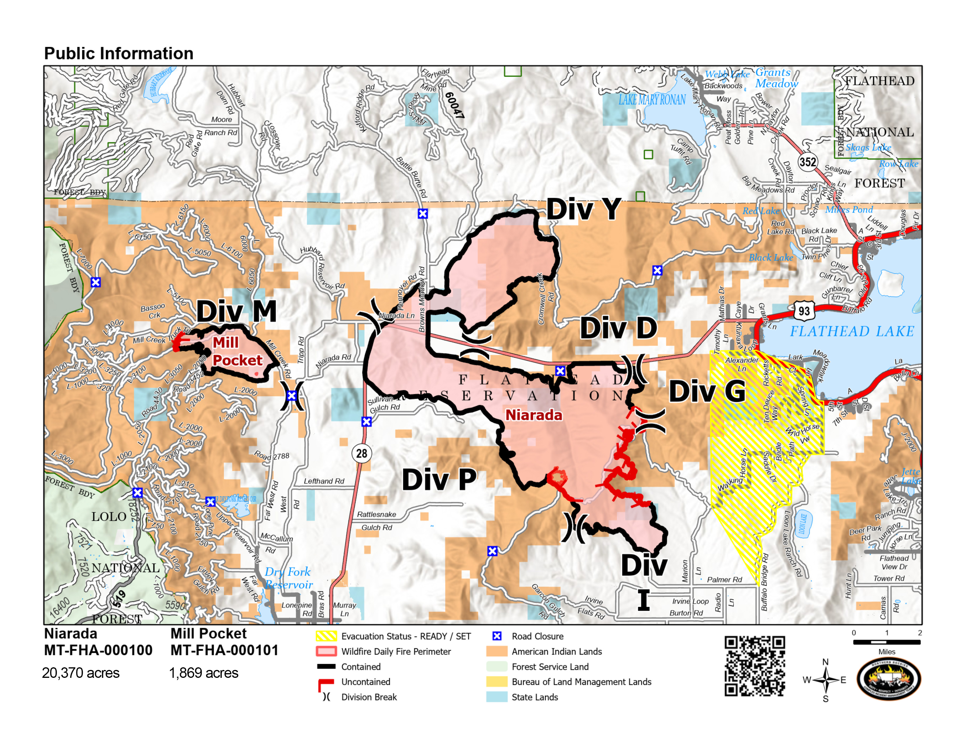
Firefighters working the southern edge of the fire continue to mop up from previous firing operations and have started suppression repair work in Sullivan’s Gulch. Other areas of the fire as well as the Mill Pocket Fire are working on suppression repair and minimal mop up.
WEATHER AND FIRE BEHAVIOR
With several days of critical fire weather passed, forecasts call for reduced winds and cooler temperatures today. Highs approaching 80 and fair humidity recovery overnight tonight with even lower temperatures and higher humidity Sunday. Significant rain is forecast early next week.
CLOSURES AND SPECIAL MESSAGES
Near the Niarada Fire, the Lake County Sheriff’s Office has a PRE-EVACUATION WARNING in place for the area that includes Alexander Road, Early Dawn Road, Spring Lane Road, Walking Horse Lane, Windward Heights Road, Wildhorse View, Buffalo Bridge Road, Saddle Drive, Island Butte Lane, Bridle Path, Ten Deuce Way, Cliffview Drive, and Ricketts Road. The remainder of the town of Elmo is in READY status.
A PRE-EVACUATION WARNING means you may be in your home. However, as there still is a risk from both fires, those in this status should not bring back evacuated livestock until the area is downgraded to READY status.
A temporary flight restriction (TFR) is in effect over the fire area and pilots should obtain up-to-date information about TFRs from the FAA or flight service. Do not fly unmanned aircraft (drones) near the fire areas under any circumstance. Drones are hazardous for pilots, and the firefighters on the ground who rely on aircraft support. Remember, if you fly, we can’t!
FIRE RESTRICTIONS
Stage 2 fire restrictions are in place across the Flathead Indian Reservation as well as Lake, Flathead and Sanders counties. No campfires are allowed, no smoking outside of vehicles, no operating combustible engines from 1 p.m. to 1 a.m., no operating vehicles off designated roads and trails. Residents and visitors are encouraged to visit www.MTFireInfo.org for more fire information across Montana.
Fire Information: 406-647-0446 | 2023.Niarada@firenet.gov
Location: Niarada - 12 miles west of Elmo, MT | Mill Pocket: 3 miles West of Hwy. 28
Start Date: Niarada - 7/30/2023 | Mill Pocket – 7/30/2023 Cause: Lightning Structures Damaged: 4
Acres/Containment: Niarada–20,365 acres, 90% contained | Mill Pocket– 1,869 acres, 95% contained
Total Personnel: 323 total Engines: 21 Aircraft: 1 + others available as needed Hand Crews: 7
Ridge Creek Fire Update for August 19 2023
Related Incident:
Publication Type: News
Ridge Creek Fire
Idaho Panhandle National Forests, Coeur d’Alene River Ranger District
Fire Information: 208-953-7022
Media Information: 989-292-9373
2023.ridgecreek@firenet.gov
https://inciweb.nwcg.gov/incident-information/idipf-ridge-creek
August 19, 2023
Location: Approximately 3.5 miles east of the north tip of Hayden Lake, along the Hayden Creek Road (FSR 437) in the Ridge Creek drainage.
Start Date: 8/3/2023 Cause: Human/Under Investigation Size: 4,020 acres Containment: 12% Total Personnel: 521 Engines: 20 Heavy Equipment: 6 Crews: 12
A community meeting for the public is planned for 3:00 PM this Sunday afternoon, August 20, at the Athol Community Center, 30355 3rd St., Athol, ID 83801. The meeting will be live-streamed on the Idaho Panhandle NF Facebook Page: https://www.facebook.com/USFSIPNF/ Structure protection staff will be placing water-handling equipment in the Bunco and Trapper Creek areas as a precautionary measure. The Kootenai County Office of Emergency Management has issued a notice for residents in the Bunco area, changing their Ready, Set, Go Status to ‘Set’. A revised Ready, Set, Go map is enclosed with this update. Weather will moderate today, giving fire crews and aviation resources greater opportunity to engage the Ridge Creek Fire.
FIRE STATUS
Despite challenging conditions over the last few days, crews were able to hold and strengthen firelines on the Ridge Creek Fire, particularly along the southern and western flanks of the fire. As anticipated, with strong southwest winds, the fire moved to the northeast resulting in the increased acreage reported today. The size of the fire is currently estimated at 4,020 acres and 12% containment, which is reflected on the enclosed maps. Crews will continue to hold and strengthen existing containment lines on the western, southern, and eastern perimeters. Crews will continue to use firing operations, particularly at night, to improve and widen containment lines by burning away shrub and surface layer fuels.
With diminished winds today, as compared to yesterday, conditions for the use of aircraft will be improved. As visibility improves, aircraft will be observable, particularly over the northeast area of the fire. Aviation assets continue to be prioritized regionally and nationally based on values at risk.
A night shift of engines will continue to be used to patrol west, south, and east perimeters to monitor fire behavior. Smoke from the Ridge Creek Fire, and smoke from fires to the west and north of the Hayden Lake area, including fires in Canada, will likely remain visible into the afternoon.
WEATHER AND FIRE BEHAVIOR
Weather will moderate noticeably today. This should serve to moderate fire behavior. Temperatures will approach 80 degrees; minimum relative humidity will remain low, varying between 16-20%. Overnight humidity recovery will be poor, reaching approximately 36%. Low relative humidity with moderate winds and temperature may still produce active fire behavior in portions of the fire and smoke is likely to be visible. Air quality information is available at www.airnow.gov and www.wildlandfiresmoke.net. Winds will be light at 8 mph, gusting to approximately 18 mph. Winds will shift and flow out of the northeast, which will tend to move the fire back into its existing footprint where extensive efforts have been made to strengthen containment lines.
EVACUATION STATUS
The Kootenai County Office of Emergency Management has issued an alert to inform residents of the identification of READY, SET, GO areas in the vicinity of the Bunco Road and Hayden Lake. Status for residents in the Bunco Road area has been change to ‘SET’ and the ‘READY’ area has been expanded. In ‘SET’ status, residents are directed to be prepared for an evacuation if notified.
The Kootenai Office of Emergency Management provides the following direction for residents in areas designated with a SET status: “you are alert to the Ridge Creek Fire in your area, that you are packed to leave and prepared to leave at a moment’s notice if you must evacuate. If you have livestock or special circumstances you have begun to take the necessary steps to address these concerns and made arrangements to relocate livestock if necessary.”
A map of the revised READY, SET, GO areas is included with this update. All residents should be familiar with evacuation procedures and consistently adhere to good fire prevention measures. More information is available at https://www.kcsheriff.com/186/Emergency-Management”
CLOSURES AND SPECIAL MESSAGES
There is a 24-hour per day Temporary Flight Restriction (TFR) in place for the Ridge Creek Fire to prevent incursion of civilian aircraft into the area used by fire-fighting aircraft. This restriction also applies to the use of drones in the TFR area.
Firefighting aircraft are shared resources among numerous fires within the region, including the Ridge Creek Fire. These aircraft will continue to use area waterways, including Hayden Lake, for fire suppression efforts. This means that residents and recreational boaters are likely to see either helicopters or fixed-wing aircraft using the lake. For planes in particular, this requires a long, linear approach and exit from the lake. This restricts their ability to maneuver abruptly should watercraft be within their flight path, creating a serious safety hazard for both boaters and pilots.
The Ridge Creek Fire has a substantial fleet of aircraft available to support ground operations. Expect to see both fixed-wing aircraft and helicopters working, particularly on the northeast area of the fire. Again, if you are a recreational boater and you observe aircraft using either Lake Hayden or Lake Pend Oreille, you should restrict your activities to the shore area of the lakes.
The Coeur d’ Alene Dispatch Zone has issued Stage II Fire Restrictions for the Idaho panhandle. All of Kootenai County is within the Stage II Fire Restrictions area. See the flyer included with this update.
The Idaho Panhandle National Forests issued an emergency closure (Closure Order #01-04-03-23-002) effective August 4, 2023. This Order is for public and firefighter safety due to heavy fire traffic on the area impacted on the Coeur d’Alene River Ranger District, and prohibits all methods of travel (foot, mechanized, motorized and stock) on Forest Service Roads 392, 428A, 437, 1511, 1530, 1552, 1587 and Forest Service Roads 206 and 406 north of their junction, Forest Service Trails 69, 78, 234, and 802 as well as within the described area.
Fire Update Elkhorn Fire August 19 2023
Related Incident: Elkhorn Fire
Publication Type: News
McCall, Idaho – The Elkhorn Fire remains 26,048 acres and 45% complete. Today will be warmer with the chance of showers increasing into the evening. A major weather change will begin on Sunday when the first surge of tropical moisture moves north into our region. Potential heavy rainfall from moisture associated with Hurricane Hilary could increase risk of flooding, rock and mudslides, and debris flows. Heavy rainfall (over an inch) is expected Sunday through Tuesday. Steep terrain combined with a severe burn scar and precipitation can result in flash flooding within minutes of precipitation beginning. For weather updates visit the National Weather Service Missoula Forecast Office https://www.weather.gov/mso/. Learn how to prepare at https://www.ready.gov/floods.
There is a detour on the Divide Trail #505 while firefighters and heavy equipment are working from 8:00 a.m. to 8:00 p.m., in this area. They will be removing merchantable logs to landing piles, masticating debris, and beginning implementation of waterbars. The alternate route is from the junction of the Divide Trail #505 and Forest Road 468, west to Forest Road 1172, northeast to the Red River Road #234, then southeast on Forest Road 1170 to Forest Road 1170C to the junction of Forest Road 1170C and the Divide Trail #505. Fire personnel will also be using boats, helicopters, and vehicles to backhaul structural protection equipment no longer needed from Whitewater Ranch downriver to China Bar.
Communication continues with the boaters entering the river at Corn Creek and again at Hancock Rapids before entering the fire footprint along the river corridor. Boaters are required to stop at Hancock Campsite on river-left, at river mile 26.1 to receive further instruction via a river information board regarding passing through and camping in the area of the Elkhorn Fire. Please read the river information board for any changes that may have occurred since you left Corn Creek launch. Camping, recreating (i.e., picnic, bathroom breaks and beach walking) and stopping through the area of Elkhorn fire activity is allowed with some exceptions. Once past Hancock Camp (River Mile 26.1) there is no stopping until boaters pass Magpie Creek Camp (River Mile 29.6). After passing Magpie Creek Camp, boaters will be allowed to camp and recreate on a First Come, First Served basis everywhere except: Upper Allison, Allison, Lower Allison, Whitewater Camp. After passing Whitewater Ranch (River Mile 39) there are no restrictions connected to the Elkhorn Fire. For additional information on rafting, contact the river desk at 208-756-5587 or 208-481-2625.
The U.S. Forest Service Nez Perce-Clearwater and Payette National Forests issued the Elkhorn fire area, roads and trails closure order #01-17-05-23-003, https://www.fs.usda.gov/alerts/nezperceclearwater/alerts-notices/?aid=82169 that spans both sides of the Salmon River but excludes the Salmon River Wild and Scenic Corridor below the high-water line.
A Temporary Flight Restriction (TFR) is in place for a two-mile buffer around the fire perimeter. All aircraft (including drones) not assigned to the fire are required to remain out of the TFR area between 0900-2100.
Fire info and daily air quality updates are available on InciWeb https://inciweb.nwcg.gov/incident-information/idpaf-elkhorn-fire and the Payette National Forest Facebook https://www.facebook.com/payettenationalforest.
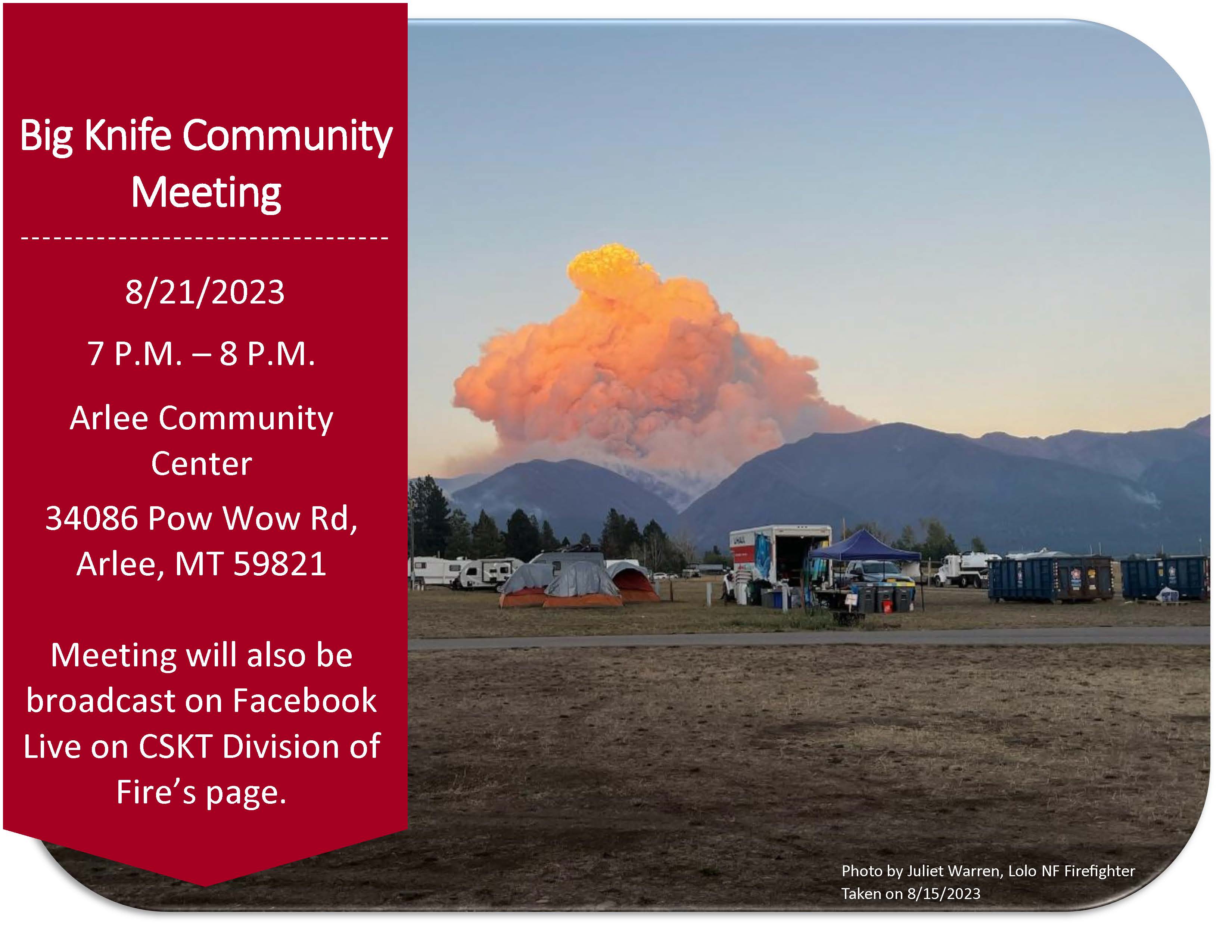
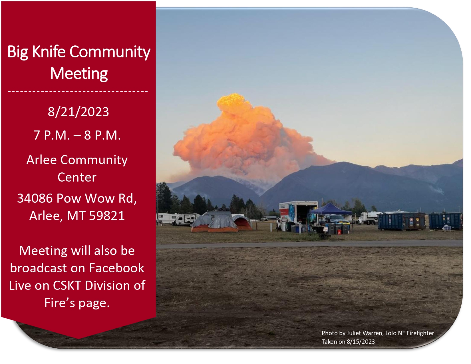
Community Meeting August 21
Related Incident: Big Knife
Publication Type: Announcement
Big Knife Fire Community Meeting at the Arlee Community Center at 34086 Pow Wow Rd., Arlee, MT on Monday, August 21 at 7:00 PM.
![]()

August 19 2023 Daily Update
Related Incident:
Publication Type: News
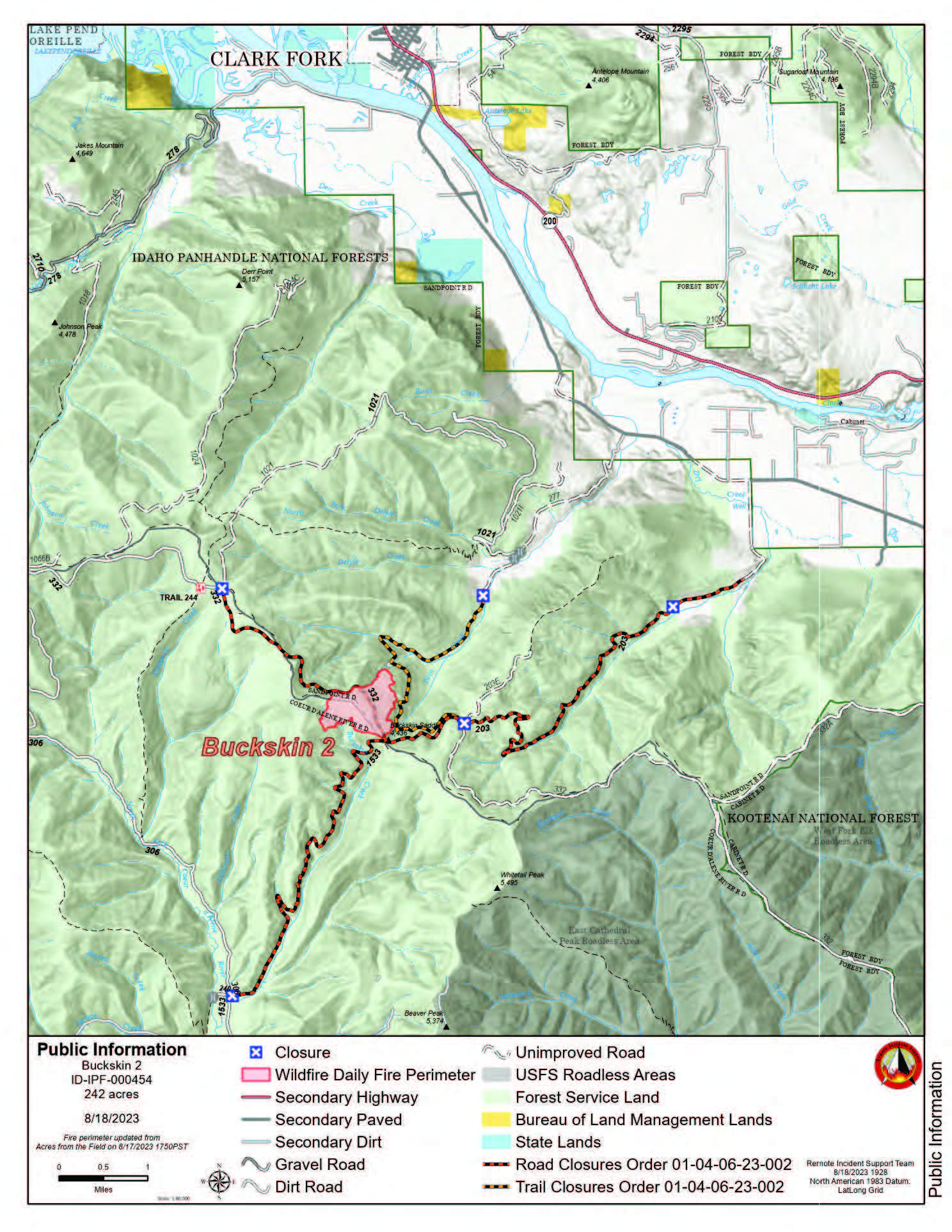
Buckskin 2 Fire - August 19, 2023
Idaho Panhandle National Forests, Sandpoint Ranger District
Fire Information: 208-557-8813
https://inciweb.nwcg.gov/incident-information/idipf-buckskin-2-fire
Type 3 Incident Commander, Brian Hicks
Location: Located approximately 8 miles due south of Clark Fork, ID on the upper end of Twin Creek and Buckskin Saddle, south of Highway 200
Start Date: 8/4/2023 Cause: Undetermined Size: 242 acres Containment: 55% Total Personnel: 171 Engines: 8 Hand Crews: 4 Modules: 2
Heavy Equipment: 3 Dozers, 2 Skidgens, 1 Water Tender
Thanks to all the hardworking firefighters and despite the week of challenging weather, fire managers have been able to increase containment to 55%. There has been no growth on the fire in several days. Fire behavior within the interior has become minimal, with some backing, flanking, and occasional tree torching. As the winds continue to test the fire lines through the weekend, firefighters will remain focused on gridding and monitoring for any possible new spot fires over the line. Crews and heavy equipment are increasing the depth while extinguishing any hotspots near the existing firelines. Engine crews have completed the structure protection assessments in the Twin Creek and Rearden Road areas. The fire remains 1.8 miles from the nearest structure.
Until a season-ending event occurs, smoke may be visible from pockets of unburned fuels within the perimeter of the fire. The smoke that has settled into the area is from existing and new large fires in Washington and British Columbia. See https://fire.airnow.gov/ for more detailed smoke information.
The locations where these fire updates were being posted, in and near Fork Clark, will no longer be updated daily. In lieu of the update, a poster with QR codes has been placed. The QR codes are direct links to the updates on INCIWEB, Facebook, and the Smoke Forecast. The published email and phone number will still be monitored.
EVACUATION STATUS
The Bonner County Sheriff’s Office issued a READY notification for the Twin Creek Rd and Rearden Rd residents in Clark Fork. To receive local status updates, sign up for Bonner County Sheriff’s Office emergency messaging through NIXLE at www.nixle.com.
CLOSURES AND SPECIAL MESSAGES
Forest Closure Order is in effect for roads associated with the Buckskin Fire; the intersection of Forest Service Roads 203 and 332, the intersection of FSR 1021 and 332, and 1533 and 306 in Clark Fork. UTV trail 77 is closed as well. An extension of the FSR 203 closure, extending to the edge of private land, took effect on 8/15 at 0700. The public is prohibited from the general area for firefighter safety and asked to practice caution while driving near firefighters and apparatuses.
Stage II Fire Restrictions are in effect. To view the Idaho Fire Restrictions Plan and a statewide map with current information regarding fire restrictions, please visit https://www.idl.idaho.gov/fire-management/fire-restrictions-finder.
A Temporary Flight Restriction is in place for the safety of our aerial resources and firefighters on the ground. This includes drones; please do not fly drones in the fire vicinity. If you fly, we can't.
WEATHER
Sunny, with a high near 89. Windy, with a west wind around 25 mph, with gusts as high as 37 mph.
***Dry Cold Front with Stronger Winds This Evening***
Winds will generally be light and terrain driven. RH Recoveries will be poor at the fire. Shower and thunderstorm chances increase Sunday afternoon and stay elevated through Tuesday.
Settings - change map background and toggle additional layers
Filter - control incident types displayed on map.
Zoom to your location
Reset map zoom and position
Could not determine your location.
Show Legend
 Wildfire
 Prescribed Fire
 Burned Area
Response
Burned Area
Response Other
Other