
Settings - change map background and toggle additional layers
Filter - control incident types displayed on map.
Zoom to your location
Reset map zoom and position
Could not determine your location.
Show Legend
 Wildfire
 Prescribed Fire
 Burned Area
Response
Burned Area
Response Other
Other
Hill Top Fire
Unit Information
Incident Contacts
2023 Klamath National Forest Lightning Fires Morning Update Aug 18 2023
Related Incident:
Publication Type: News
Yreka, Calif., August 18, 2023 — The Klamath National Forest continues to manage a number of fires on the Happy Camp/Oak Knoll and Salmon/Scott River Ranger Districts:
Happy Camp/Oak Knoll District:
- The Den Fire, north of the community of Horse Creek, was reported yesterday evening with rapid rates of spread. It is estimated to be 50 to 100 acres and has line and hose around it. Firefighters from nearby incidents were on scene quickly yesterday and aggressively suppressed the fire.
- The Titus Fire is in the Marble Mountain Wilderness south of Norcross Campground. It was last reported at 15 acres. It received significant rain on Tuesday which moderated fire behavior. It is within the 2021 McCash Fire footprint with numerous snags in steep country. It will be monitored by air to evaluate suppression needs.
- The Berry Fire is .2 acres near Huckleberry Mountain has line around it.
- The Indy Fire is a small fire up Independence Creek near the border of the Marble Mountain Wilderness in the 2021 McCash Fire footprint.
- The 5-acre Doe Fire, located near Doe Peak, is controlled and in patrol status.
- The Devil Fire is 2.5 acres near Seiad Low Gap and is contained.
- The Swillup Fire between Pony Peak and Bear Peak roads is .1 acres and contained.
- The Brown Fire is .1 acres and contained.
- The Dutch Fire is .1 acres and is contained.
- The Intersection Fire is .1 acres and is contained.
Salmon/Scott River Ranger District:
- The Shadow Fire is holding at about 2 acres in the Marble Mountain Wilderness near Sky High Lakes. Firefighters are continuing to work the fire and it is 75% contained.
- The Lake Fire is near the Shadow Fire and has grown to roughly 100 acres; Salmon River Hotshots are assigned. It is being managed by a Type 3 Team.
- The Block Fire is near Lake Mountain and has been reported as a single tree. Resources are assigned.
- The Boulder Fire is .1 acres near Indian Scotty Campground and is contained.
- The Hossick Fire is .1 acres up Hossick Gulch near Scott Bar and is contained.
California Interagency Incident Management Team 5 has taken over management of a number of fires on the Klamath National Forest, including the Elliott, Canyon, Malone, Ufish, Three Creeks, Devil, Block, Head, Townsend, Gold, and Scott fires as part of the Happy Camp Complex.
“We appreciate our forest firefighting resources for their flexibility and resiliency. We are navigating a very dynamic fire environment with constantly shifting priorities,” said Forest Fire Management Officer Mike Appling.
Firefighting resources continue to come to the Klamath National Forest to support existing fires and bolster initial attack resources. Aerial firefighting assets are available but have been largely unable to fly due to smoke inversion conditions.
Evacuation Orders and Warnings remain in effect. Monitor CodeRED and the @SiskiyouCountySheriff for current information.
Closures:
Pacific Crest Trail is closed from Etna Summit to the Oregon Border. Hikers and all backpackers are asked to stay off the trail in that area.
Dillon Creek Campground is closed due to proximity to the Elliot Creek Fire.
Highway 96 and the Scott River Road have hard closures.
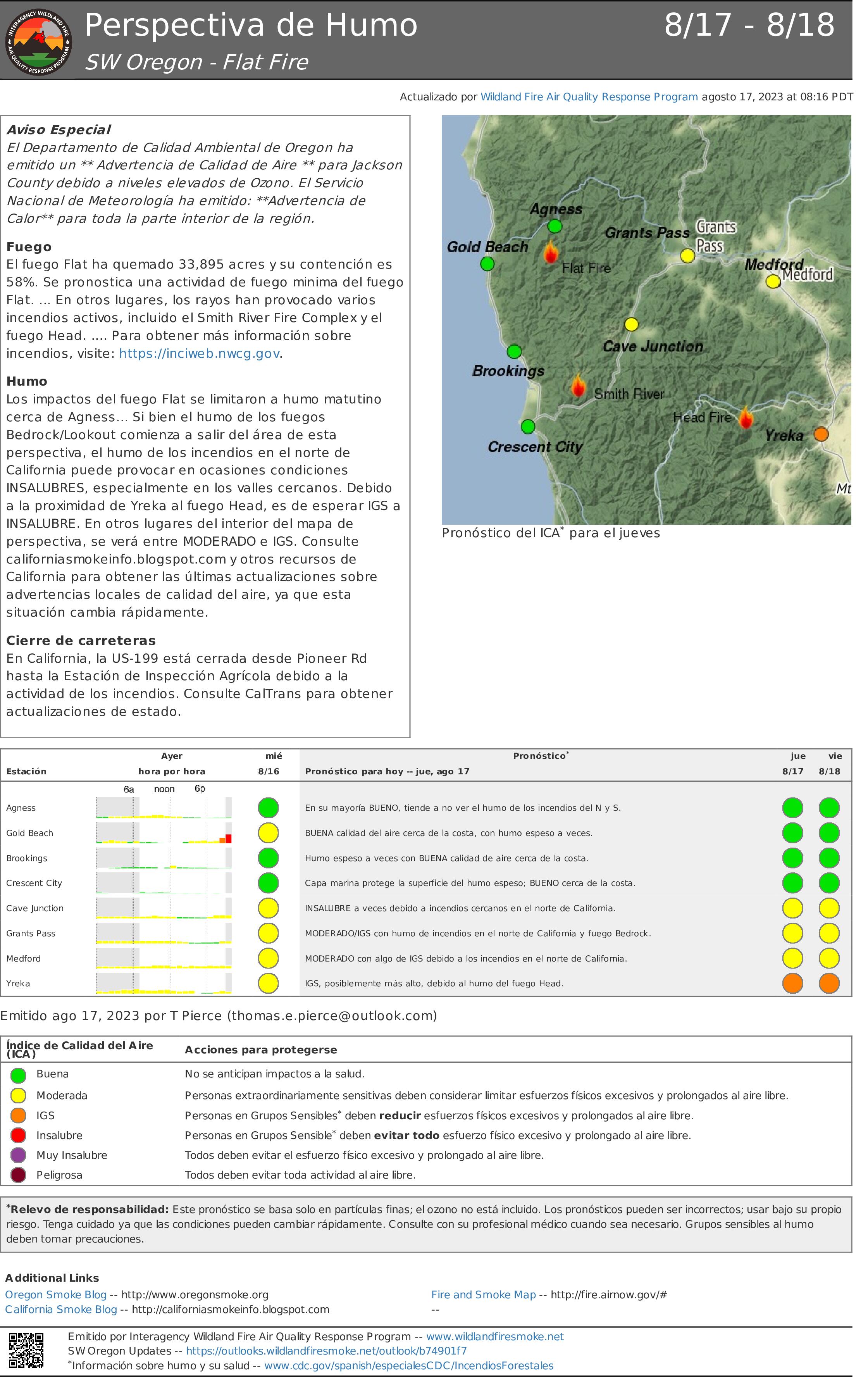
18 de agosto 2023 Informacin al da para el Incendio Flat
Related Incident: Flat Fire
Publication Type: News
Extensión: 33,895 acres Fecha de Inicio 15-julio-2023
Origen: 2 millas Suroeste de Agness, OR
Contenido: 58%
Personal: 590
Recursos: 21 camiones de bomberos l 13 escuadrillas de bomberos l 3 buldóceres l 20 cisternas l 7 máquinas masticadoras l 4 helicópteros
Resumen: El día de hoy, a las 6:00am, se transmitió el comando del Incendio al grupo para el Manejo de Incidentes del Suroeste, Tipo 3. Las condiciones climáticas se presentan calientes y secas, influyendo en la reducción del nivel de propagación del fuego dentro del material de combustión que aún permanece intacto. No es inusual encontrar árboles en llamas, solitarios y aislados, pero no representan ningún peligro para las líneas de incendio. Dependiendo de la actividad del viento, se podrá experimentar de una manera intermitente el impacto del humo sobre las comunidades locales. Los bomberos, se encuentran observando detenidamente las líneas de contención y poniendo atención a las fuentes de emanación de calor en el área afectada. Tienen como una misión primordial, el enfocarse en la concentración del viento y en la alineación de las laderas en los drenajes y al viento sobre las cumbres provenientes del Noroeste los cuales podrían producir una propagación rápida de fuego en la zona. Otra escuadrilla de bomberos está a punto de finalizar el mejoramiento de la línea de contención a lo largo de las carreteras Forestales 3680, 3318 y en la línea construida por buldóceres dirigida hacia Illinois River. Se continua el despliegue de varias escuadrillas con el objetivo de apoyar al Bosque Nacional de Six Rivers debido al surgimiento de incendios al sur de la frontera de Oregon/California.
Actividades para el día de hoy: Los recursos aéreos y sobre el terreno, consideran un trabajo primordial la realización de las evaluaciones visuales de la actividad en el perímetro del incendio. El trabajo sobre la carretera forestal 360 dentro del drenaje de Meadow Creek, está cercano para ser completado. Se finalizo la construcción de línea a mano a lo largo de la extensión de Meadow Creek hacia la línea de buldócer sobre la carretera forestal 365. Otras escuadrillas de bomberos han logrado progresar en el mejoramiento de la línea de contingencia construida con buldócer y localizada sobre la carretera forestal 3680 a través de la preparación, astillado y eliminando la maleza en el camino forestal 310. Asimismo, los bomberos llevaran a cabo la ardua tarea de completar la línea de contingencia construida por buldócer que se extiende desde la carretera forestal 362 hacia el drenaje de Pistol River uniéndose con otra línea construida a mano desde la línea de buldócer hasta el área Oeste. En caso de ser necesario, los recursos aéreos permanecen disponibles para apoyar los esfuerzos de ataques iniciales en cualquier momento. El único objetivo que mantienen los bomberos en el Incendio Flat es la supresión total del mismo y no se detendrán hasta haber garantizado esta misión
Condiciones climáticas: Con una tendencia fría y el porcentaje de la humedad relativa más alto, ayudara a minimizar la actividad en el comportamiento del incendio. Para el viernes y el fin de semana, continuaran presentándose temperaturas más frescas en el área. Asimismo, este fenómeno climático permitirá el paso de una tendencia de humedad más alta que las anteriores. Existe una posibilidad de un 5 – 10% en la presencia de lluvia o tormentas aisladas sobre la zona.
Impacto del humo: Se podrá observar el humo desde las áreas aledañas al incendio.
Las predicciones del humo están disponibles en: https://outlooks.airfire.org/outlook/b74901f7?
Cierres de áreas: El U.S. Highway 199 ha sido cerrado al Norte de Gasquet debido a incendios en el Bosque Nacional de Six Rivers, por favor use la ruta U.S. Route 101 hacia SR 42s para viajar hacia y desde Rogue Valley. Las carreteras del Servicio Forestal y BLM no deberán ser utilizadas como rutas alternativas debido a la actividad de surgimiento de incendios en la zona. El Bosque Nacional de Rogue River-Siskiyou a declarado una orden de cierre incluyendo senderos, caminos y una porción del área de Illinois River. Información acerca los cierres en el área del Incendio pueden encontrarse en: https://bit.ly/RRSNFAlerts
Evacuaciones: Todos los niveles de evacuación han sido reducidos a un Nivel 1 “Prepárese” para todas las áreas en las proximidades del Incendio Flat. https://tinyurl.com/currycountyem
Orden de restricción: Actualmente, el Nivel de Peligro de Incendio es “Extremo”. El Bosque Nacional de Rogue River-Siskiyou implemento un Nivel 3 en las Restricciones para el Uso Público (PURs). Asimismo, se encuentra en pie un Nivel 3 (PURs) para la Sección Nacional Virgen de Rogue que fue implementada por el Bosque Nacional de Rogue River-Siskiyou, BLM en Medford y ODF. Para mayor información visite: https://tinyurl.com/ueuznr6e\
Chilcoot Fire Fact Sheet August 18 2023
Related Incident:
Publication Type: News
The Central Idaho Dispatch Zone is at HIGH Fire Danger
CENTRAL IDAHO FIRE RESTRICTIONS AREA IS IN STAGE I FIRE RESTRICTIONS
Fire Size: Infrared flight on August 16 mapped the fire at 685 acres. Acreage will be updated after next infrared or reconnaissance flight.
Cause: lightning
Location: Two (2) miles northeast of Pistol Lake between Browning and Little Pistol Creeks on the western edge of Middle Fork Ranger District in the Frank Church River of No Return Wilderness. The Chilcoot Fire is surrounded by previous fires including the Cascade Complex (2007), Kiwah (2018), Pistol (2018), and Buck (2020) Fires.
Fuels: spruce and fir
Fire spread: The fire is burning in heavy dead and down fuels; fire activity is creeping and smoldering. The fire is increasing in size each day with fire movement down into Garand Creek and fire has crossed Garand Creek and is moving east towards Little Pistol Creek.
Planned actions: Firefighter and public safety is the number one priority for the Chilcoot Fire. When the fire was initially sized up, fire managers initiated actions to suppress the fire. Due to the remote location of the fire, the steep and inaccessible terrain along with lack of safe ingress and egress for firefighters, fire managers changed strategy, keeping firefighter safety in mind. Fire managers will be monitoring the fire by remote camera and reconnaissance flights. Values at risk in the area have been identified and trigger points have been established. If a trigger point is reached, additional actions will be taken by firefighters in order to protect those values at risk.
Weather: Isolated thunderstorms should dissipate this evening. Gusty, erratic winds along with brief heavy downpours are possible around storms. Gusty non-thunderstorm winds should diminish this evening. Isolated to scattered thunderstorms are possible once again Saturday afternoon. On Sunday, widespread rain will arrive as the remnants of Hurricane Hilary arrive. Heavy rain and flooding is possible Sunday into Monday.
Lookout Fire Updated Closure 8182023
Related Incident: Lookout Fire
Publication Type: Closures
UNITED STATES DEPARTMENT OF AGRICULTURE
FOREST SERVICE
WILLAMETTE NATIONAL FOREST
SPRINGFIELD, OREGON
ORDER # 06-18-01-23-22
FOREST ORDER
LOOKOUT FIRE EMERGENCY AREA CLOSURE
Pursuant to 16 U.S.C. § 551 and 36 CFR § 261.50 (a) and (b), and to provide for public safety,
the following acts are prohibited on the National Forest System (“NFS”) areas, roads, and trails
described below within the administrative boundaries of the Willamette National Forest. This
Order is effective on August 18, 2023, through September 18, 2023, unless otherwise rescinded
sooner. This order supersedes and rescinds ORDERS # 06-18-01-23-19 and #06-18-01-23-20,
which was signed August 11 and 14, 2023 by Forest Supervisor David Warnack.
PROHIBITIONS:
1. Being on the road. 36 CFR § 261.54(e)
2. Being on a trail 36 CFR § 261.55(a)
3. Entering into or being upon National Forest System Lands closed for the protection of public
health and safety. 36 CFR § 261.53(e)
CLOSURE AREA:
The closure area is located within the State of Oregon, Lane and Linn Counties, and within the
Administrative Boundaries of the Willamette National Forest. The closure applies to the NFS
areas, roads, and trails and trailheads described below. The closure area is depicted on the
attached map, which is incorporated into this order as “Exhibit A”. All areas, roads, trails,
campgrounds, and rec sites in this closure area are closed. Roads closed by this order are
depicted in “Exhibit B” and recreation sites, trails and campgrounds closed by this order are
depicted in “Exhibit C”.
Area Closure Description
The closure boundary starts at the junction of Hwy 126 and Forest Road (FR) 2620-125,
Township 16S, Range 4E, Section 21. The closure boundary proceeds north along FR 2620-
125 to Quartz Creek and then proceeds north along Quartz Creek to the McKenzie River
Ranger District and Sweet Home Ranger District border. It then continues along that boundary
northeast approximately 6 miles to the intersection with FR 1509 at Gold Hill Trailhead (northern
intersection). The closure boundary then follows FR 1509 to FR 15 Junction then proceed to
follow the McKenzie River Ranger District Boundary with the Sweet Home Ranger District
approximately 6 miles to FR 2672-655 then proceed to FR 2672 junction. Then follow FR 2672
to the Highway 126 junction. The closure then follows Highway 126 south to the FS 2654
junction. Then follow Highway 126 To Forest Service boundary. The southern closure boundary
then follows the Forest Service boundary along Highway 126 west to the beginning point.
FS Road 15 will be closed to through traffic.
ORDER #06-18-01-23-22
EXEMPTIONS:
Pursuant to 36 CFR § 261.50(e)(1) and (4), the following persons are exempt from this Order:
(1) Persons with Forest Service Permit No. FS-7700-48 (Permit for Use of Roads, Trails,
or Areas Restricted by Regulation or Order) specifically exempting them for this
Order.
(2) Any Federal, State, or Local Officer, or member of organized rescue or fire fighting
force in the performance of an official duty.
These prohibitions are in addition to the general prohibitions in 36 CFR Part 261, Subpart A.
Violations of these prohibitions are punishable by a fine of not more than $5,000.00 for an
individual or $10,000.00 for a corporation or imprisonment for not more than six months
or both. 16 U.S.C. § 551 and 18 U.S.C. § 3551, 3571, and 3581.
Executed in Springfield, Oregon on this 18 day of August 2023.
David Warnack
Forest Supervisor
Willamette National Forest
August 17 2023 Daily Update
Related Incident:
Publication Type: News
Yesterday air resources actively worked to contain the East Fire that is located about ten miles east of Cascade by utilizing retardant and water to help firefighters on the ground. Several retardant planes, scooper planes, and helicopters utilized ridge lines and trails to create an anchor point at the East Mountain Repeater site. Hand crews dug direct fire line next to where retardant planes laid layers of retardant. As the day went on, line construction personnel increased as crews came in from across the country to aid in suppressing the fire. This fire is being fought with a full suppression strategy.
The fire is burning in heavy, thick timber that has a lot of dead standing and downed trees. Some of those trees are sub alpine fir that throw embers out and create spot fires ahead of the main fire. Values threated include the East Mountain repeater site, timber sales, trail systems, and private timber lands.
Additional hand crews and engines are in route to help fight the fire. A Great Basin Type 2 Incident Management Team, which will provide increased operational and logistical capabilities, will be briefed this evening and work with current firefighting resources to become familiar with the fire area. They will take command of the fire tomorrow, Aug 19.
To ensure firefighter safety, please limit unnecessary traffic near the fire area and especially the Clear Creek Road, Forest Road 409.
Weather: Isolated showers with thunderstorms are possible today. Some of the storms could produce gusty winds with gusts as high as 24mph. Highs will be near 82 with South Winds 3-7 mph.
Closure Area: expected to be issued later today.
Forest closes portion of Yolla Bolly Middle Eel Wilderness due to Slide 1 Fire
Related Incident: 2023 Slide 1
Publication Type: Closures
Forest officials have issued a closure order for a portion of the Yolla Bolly Middle Eel Wilderness, including several trailheads, trails and roads, effective today, Aug. 18 through April 1, 2024.
The Slide 1 Fire, which began on Aug. 15 after more than 150 lightning strikes on the forest, prompted officials to issue the closure order.
Firefighters are actively using the roads, trails and recreation sites in the closure area.
Access for any recreation activities including hunting or hiking is prohibited in the closure area.
“We know it is hunting season, and people want to camp and hunt in their favorite spots. However, this closure is necessary to protect the public as well as our fire personnel from potential injury due to hazards in the fire area,” said Forest Supervisor Wade McMaster.
Except for this closure and the State Game Refuge, the rest of the forest is open to hunting during the seasons designated by the California State Department of Fish and Wildlife.
Officials also want to remind visitors that fire restrictions are in effect, prohibiting campfires, open flames or stove fires while dispersed camping. Within designated fire-safe recreation sites and wilderness areas, campfires are allowed with a valid permit.
The M22 Road remains open, however visitors should drive with caution and expect fire traffic.
Areas closed include:
- Yolla Bolly Middle Eel Wilderness area within the Grindstone Ranger District
- Ides Cove Backpacker Trailhead
- Ides Cove Horsepacker Trailhead
Trails closed include:
- 9W01
- 9W03
- 9W04
- 9W51
- 9W54
- 9W80
- 10W09
- 10W93
- 10W91
Roads closed include:
- 25N14
- 25N24
- 25N19
- 25N19A
- 25N19C
- 25N21
- 25N21C
Emergency personnel on official duty and anyone with a permit specifically exempting them are exempted from this order.
New Evacuation Warnings from Siskiyou County OES August 18 1145 am
Related Incident: 2023 Happy Camp Complex Klamath NF
Publication Type: Announcement
From the Siskiyou County Office of Emergency Services
?????? ???? ??????????? ??????
??? ????? ????? ?? ????????
*PLEASE NOTE ???? ???-1402 has been added to warnings*
Due to fire activity on the #elliotfire the Siskiyou County Sheriff’s Office, with the support of our fire partners, is issuing an ?????????? ??????? for the following zone(s):
???? ???-???? (????? ?? ??????? ??)
???? ???-???? (????? ?? ?????? ????? ?????)
PLEASE BE CONSIDERATE OF ROAD CLOSURES.
- Residents under EVACUATION ORDERS need to evacuate IMMEDIATELY.
- Residents under EVACUATION WARNINGS need to be ready to evacuate.
- Surrounding areas should be ready to evacuate if needed.
- See ZoneHaven Map for more information: community.zonehaven.com
- Resources are continuing to arrive at the incident.
- SHELTERS -
If you are in need of shelter, the Kahtishraam Wellness Center (1403 Kahtrishraam, Yreka, CA 96097) is open to those affected. If you have questions about the shelter, please call 530-340-3539.
We want to ensure the public of our commitment to provide adequate time for safe evacuation should fire behavior intensify to the point of issuing Evacuation Orders in the future.
Visit community.zonehaven.com for current evacuation zone statuses
August 18 2023 Daily Update
Related Incident:
Publication Type: News
Yesterday air resources actively worked to contain the East Fire that is located about ten miles east of Cascade by utilizing retardant and water to help firefighters on the ground. Several retardant planes, scooper planes, and helicopters utilized ridge lines and trails to create an anchor point at the East Mountain Repeater site. Hand crews dug direct fire line next to where retardant planes laid layers of retardant. As the day went on, line construction personnel increased as crews came in from across the country to aid in suppressing the fire. This fire is being fought with a full suppression strategy.
The fire is burning in heavy, thick timber that has a lot of dead standing and downed trees. Some of those trees are sub alpine fir that throw embers out and create spot fires ahead of the main fire. Values threated include the East Mountain repeater site, timber sales, trail systems, and private timber lands.
Additional hand crews and engines are in route to help fight the fire. A Great Basin Type 2 Incident Management Team, which will provide increased operational and logistical capabilities, will be briefed this evening and work with current firefighting resources to become familiar with the fire area. They will take command of the fire tomorrow, Aug 19.
To ensure firefighter safety, please limit unnecessary traffic near the fire area and especially the Clear Creek Road, Forest Road 409.
Weather: Isolated showers with thunderstorms are possible today. Some of the storms could produce gusty winds with gusts as high as 24mph. Highs will be near 82 with South Winds 3-7 mph.
Closure Area: expected to be issued later today.
Ridge Doris Point and Tin Soldier Fire Update
Related Incident:
Publication Type: News
Ridge, Doris Point, and Tin Solider Fire Update
Ridge Fire:
Location: 6 miles southeast of Hungry Horse
Size: 3474 acres
Percent Contained: 20%
Cause: Lightning
Start Date: July 30, 2023, 3:45 PM
Number of Personnel Assigned: 659
Doris Fire:
Location: 8 miles south of Hungry Horse
Size: 597 acres
Percent Contained: 0%
Cause: Lightning
Start Date: July 30, 2023, 3:45 PM
Number of Personnel Assigned: 2
Tin Soldier:
Location: 17 miles east of Swan Lake
Size: 5966 acres
Percent Contained: 0%
Cause: Lightning
Start Date: July 30, 2023, 3:45 PM
Number of Personnel Assigned: 89
Fire Information: 406-998-6074
Hours: 8:00 AM – 7:00 PM
Email: 2023.ridge@firenet.gov
Incident Website: Ridge Fire: http://inciweb.wildfire.gov/incident-information/mtfnf-ridge-fire
Tin Soldier: https://inciweb.nwcg.gov/incident-information/mtfnf-tin-soldier-complex
COMMUNITY MEETING TONIGHT AT 7:30PM AT THE GLACIER BIBLE CAMP.
CURRENT SITUATION:
A Red Flag warning issued yesterday at 3 p.m. continues through midnight tonight. Increased hot, dry, and windy weather yesterday led to increased fire activity. Smoke conditions cleared mid-day, allowing water-dropping helicopters to work with ground forces to maintain control lines. Today’s winds are forecast to be somewhat higher than yesterday, with gusts 20-25 mph in most areas, higher on ridgetops. Today crews will continue to mop up and hold the western and northern divisions. As work is completed there, resources are moving to the east side, where firefighters continue to directly attack the fire, supported by aviation, while scouting for opportunities to build indirect and contingency fire lines.
The Doris Point fire due to more accurate mapping is currently 597 acres. Fire personnel and Flathead National Forest have completed structure wrap and placing sprinklers to protect campgrounds and boat docks. Fire personnel continue to maintain confinement, containment, and point protection strategy in coordination with the Flathead National Forest.
This morning, California Interagency Incident Management Team 4 assumed command of the Tin Soldier Fire, which includes the Sullivan and Bruce Fires. Today’s actions will focus on continuing to improve structure protection efforts for the commercial guest ranches, Spotted Bear Ranger Station compound, Heinrude residential community, and other infrastructure in the area. Crews will continue fuels reduction, daily testing and pre-treatment with the sprinkler systems and water pumps for identified values at risk and conducting additional tactical firing operations as necessary. Fire personnel continue to maintain confinement, containment, and point protection strategy in coordination with the Flathead National Forest.
WEATHER:
A Red Flag Warning is in effect today through 12:00 Saturday, 8/19/2023.
Mostly cloudy in the morning and partly cloudy in the afternoon. Below 4500 ft 85 to 90 degrees mid-slope and ridge tops 80 to 85 degrees. Relative humidity is 15020% today. Expected high winds in the valleys, lower slope ridges, and upper slope, from the southwest 8-14mph and increasing to 12-18mph. Gusts up to 30mph in the valley and lower slopes and up to 40mph in the ridges and upper slopes. Temperatures are expected to cool this weekend as a cold front approach, bringing a 30-40 percent change of wetting rain on Monday and Tuesday.
RIDGE & DORIS FIRE PRE-EVACUATION NOTICE:
The Flathead County Sheriff’s Office has issued a pre-evacuation notice from the east side of Spotted Bear Road to West Glacier. Visit the Flathead Sheriff’s office for details https://www.facebook.com/flatheadsheriff
EMERGENCY SHELTER:
The American Red Cross has identified the following location as an emergency shelter for residents affected by the Ridge Fire. Those who plan to use the emergency shelter are asked to call 1-800-733-2767 prior to your arrival.
Columbia Falls Junior High School 1805 Talbot Road Columbia Falls, MT https://www.facebook.com/FlatheadOES
TIN SOLDIER FIRE EVACUATIONS, CLOSURES AND RESTRICTIONS
An evacuation has been issued by the Flathead County Sheriff for Heinrude community. Visit the Flathead Sheriff’s office for details https://www.facebook.com/flatheadsheriff
FIRE CLOSURES:
The Hungry Horse Reservoir is closed to all public access, including both the east and west side roads. As firefighting efforts continue on the Ridge Fire, the Tin Soldier, and other fires in the area, the closure is in place to provide for public and firefighter safety. https://www.fs.usda.gov/alerts/flathead/alerts-notices/?aid=82283
ADDITIONAL INFORMATION:
Residents should stay alert for changing conditions and visit ready.gov/wildfires for preparing for wildfires. Please refer to http://inciweb.wildfire.gov/incident-information/mtfnf-tin-soldier-complex for the Tin Soldier Complex Incident information