
Thompson Ridge Fire Update Aug 21 2023
Related Incident: Thompson Ridge Fire
Publication Type: News
Thompson Ridge Fire Update
Monday, August, 21, 2023
FIRE SITUATION
There is a flash flood warning in effect throughout south central Utah until midnight on Tuesday, August 22nd. Please be prepared for rapidly changing conditions.
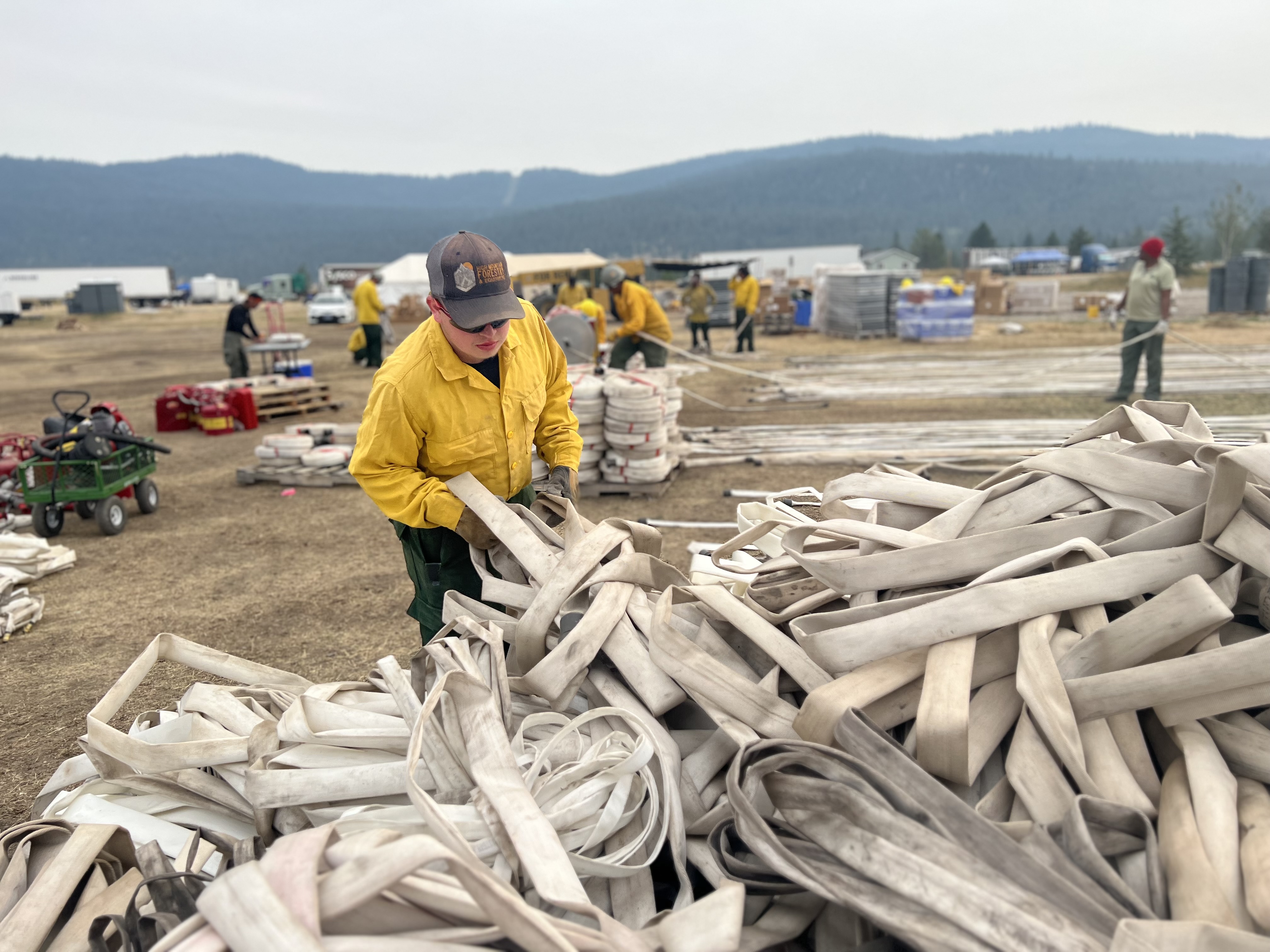
Yesterday, on the southeast corner of the fire, crews completed suppression repair work on dozer lines. Resource advisors began planting seed to take advantage of the current wet weather.
Today, crews continue to patrol and check containment lines on the Thompson Ridge Fire. They will work to repair spike camps and clean up from the previous weeks of firefighting efforts. Spotty rain and gusty winds are expected, but continued relative humidity recovery should keep fire behavior to a minimum and within containment lines.
The incoming Incident Commander and fire operations personnel are touring the fire with current staff to pass on information and situational awareness as they prepare to take command of the fire.
Tomorrow, Tuesday, August 22nd, Great Basin Team 5 will hand command of the fire back to the Fishlake National Forest.
CLOSURES
An updated closure order will go into effect on Tuesday, August 22nd and should be online at https://www.fs.usda.gov/detail/fishlake/alerts-notices soon. Use caution in formerly closed areas, as there may still be firefighting equipment accessing the perimeter along these roads.
STATUS
Start Date: August 4, 2023
Incident Type: Wildfire
Size: 7,253 acres
Cause: Lightning
Containment: 85%
Location: 10 miles southeast of Beaver, Utah
Terrain: Steep, rugged terrain in remote areas transitioning to rolling pinyon juniper hills
Structures Threatened: None
RESOURCES
Engines: 4
Water Tenders: 1
Crews: 1
Helicopters: 4
Dozers: 1
Total Personnel: 194
Niarada and Mill Pocket update for August 21 2023
Related Incident: Niarada
Publication Type: News
Firefighters on the Niarada Fire worked to backhaul excess gear and equipment Sunday as the fire moves into suppression repair mode.
Crews hauled hose, pumps, tanks and equipment as fire managers work to thin personnel numbers in the coming days and send resources to other fires that might have greater needs.

Control lines have been tested through high wind and extreme heat but now must be put back to as natural a state as possible. Hand crews, road graders, bulldozers and excavators will be used to repair and rehab areas that were impacted in efforts to stop the fire’s spread. These suppression repair efforts include chipping or stacking limbs and brush that was cut to widen roads, rehabbing and covering dozer lines, and grading roads among other things in order to leave the sight as naturalized as possible before personnel depart.
The Mill Pocket Fire is 100% contained with little suppression repair left to complete.
WEATHER AND FIRE BEHAVIOR
Showers and thunderstorms are forecast today and Tuesday with winds remaining calm. Precipitation amounts from a quarter to half an inch are predicted for today and another tenth of inch Tuesday.
CLOSURES AND SPECIAL MESSAGES
The Lake County Sheriff's office in consultation with the Niarada fire team lifted the pre-evacuation warning. All residents may bring their livestock back home.
The temporary flight restriction (TFR) has been lifted, as well. That said, do not fly unmanned aircraft (drones) near ANY fire area under any circumstance. Drones are hazardous for pilots, and the firefighters on the ground who rely on aircraft support. Remember, if you fly, we can’t!
FIRE RESTRICTIONS
Stage 2 fire restrictions are in place across the Flathead Indian Reservation as well as Lake, Flathead and Sanders counties. No campfires are allowed, no smoking outside of vehicles, no operating combustible engines from 1 p.m. to 1 a.m., no operating vehicles off designated roads and trails. Residents and visitors are encouraged to visit www.MTFireInfo.org for more fire information across Montana.
Fire Information: 406-647-0446 | 2023.Niarada@firenet.gov
Location: Niarada - 12 miles west of Elmo, MT | Mill Pocket: 3 miles West of Hwy. 28
Start Date: Niarada - 7/30/2023 | Mill Pocket – 7/30/2023 Cause: Lightning Structures Damaged: 4
Acres/Containment: Niarada–20,365 acres, 95% contained | Mill Pocket– 1,869 acres, 100% contained
Total Personnel: 130 total Engines: 4 Aircraft: Available as needed Hand Crews: 2
Ridge Doris Point and Tin Solider Daily Fire Update for August 21 2023
Related Incident:
Publication Type: News
Ridge, Doris Point, and Tin Solider Daily Fire Update for August 21, 2023
Fire Information: 406-998-6074
Hours: 8:00 AM – 7:00 PM
Email: 2023.ridge@firenet.gov
Incident Website: Ridge Fire: http://inciweb.wildfire.gov/incident-information/mtfnf-ridge-fire
Tin Soldier: https://inciweb.nwcg.gov/incident-information/mtfnf-tin-soldier-complex
Ridge Fire:
Location: 6 miles southeast of Hungry Horse
Size: 3651 acres
Percent Contained: 39%
Cause: Lightning
Start Date: July 30, 2023, 3:45 PM
Number of Personnel Assigned: 596
Doris Point Fire:
Location: 8 miles south of Hungry Horse
Size: 1534 acres
Percent Completion: 0%
Cause: Lightning
Start Date: July 30, 2023, 3:45 PM
Number of Personnel Assigned: 15
Tin Soldier:
Location: 17 miles east of Swan Lake
Size: 7697 acres
Percent Completion: 0%
Cause: Lightning
Start Date: July 30, 2023, 3:45 PM
Number of Personnel Assigned: 132
CURRENT SITUATION:
Ridge Fire: Yesterday, crews on the western and northern area of the fire continued to mop up and back haul excess equipment. Drop points in these areas were cleaned up and crews prepared for rain. On the northeastern edge, firefighters contained a few spot fires and were able to get control lines around them. To the southeast, mop up also continued. Today, crews will continue mop up activities and install control lines where appropriate to prevent fire spread to the north and east. Aviation will be utilized today as weather and winds allow.
Doris Point Fire: Crews will continue to maintain confinement, and point protection strategy on the values at risk in coordination with the Flathead National Forest. Crews will continue fuels reduction and structural prep, as well as setting up pump sprinklers.
Tin Soldier Fire: Yesterday, crews mopped up an area where fire had crossed the Meadow Creek Road and there are currently no further issues in this area. Crews will continue to maintain point protection strategy on the values at risk in coordination with the Flathead National Forest. Crews will continue fuels reduction and structural prep, as well as setting up pump sprinklers.
WEATHER:
Deep moisture associated with the remnants of Hurricane Hilary will move across the Northern Rockies today, bringing widespread rain by this afternoon, which may be moderate to heavy at times late this afternoon into this evening. Rain looks to diminish Tuesday morning, but additional moisture circulating through the area will maintain some showers through Tuesday evening.
Ridge & Doris Point: 70-75 degrees in the lower elevations and 64-69 degrees in the mid-slopes to ridges. 46-51% minimum relative humidity and winds east up 7 mph with gusts to around 15 mph on the ridgetop.
Tin Soldier: 68-73 degrees in the lower elevations and 62-67 degrees in the mid-slopes to ridges. 46-51% minimum relative humidity and winds east 5 to 10mph with gusts around 18 mph on the ridgetop.
RIDGE & DORIS FIRE PRE-EVACUATION NOTICE:
The Flathead County Sheriff’s Office has issued a pre-evacuation notice from the east side of Spotted Bear Road to West Glacier. Visit the Flathead Sheriff’s office for details https://www.facebook.com/flatheadsheriff
EMERGENCY SHELTER:
The American Red Cross has identified the following location as an emergency shelter for residents affected by the Ridge Fire. Those who plan to use the emergency shelter are asked to call 1-800-733-2767 prior to your arrival.
Columbia Falls Junior High School 1805 Talbot Road Columbia Falls, MT https://www.facebook.com/FlatheadOES
TIN SOLDIER FIRE EVACUATIONS, CLOSURES AND RESTRICTIONS
An evacuation has been issued by the Flathead County Sheriff for Heinrude community. Visit the Flathead Sheriff’s office for details https://www.facebook.com/flatheadsheriff
FIRE CLOSURES:
The Hungry Horse Reservoir is closed to all public access, including both the east and west side roads. As firefighting efforts continue on the Ridge Fire, the Tin Soldier, and other fires in the area, the closure is in place to provide for public and firefighter safety. https://www.fs.usda.gov/alerts/flathead/alerts-notices/?aid=82283
ADDITIONAL INFORMATION:
Residents should stay alert for changing conditions and visit ready.gov/wildfires for preparing for wildfires. Please refer to http://inciweb.wildfire.gov/incident-information/mtfnf-tin-soldier-complex for the Tin Soldier Complex Incident information
River Road East Fire Daily Update Monday August 21
Related Incident:
Publication Type: News
River Road East Fire
Fact Sheet
NORTHERN ROCKIES TEAM 1
INCIDENT COMMANDER: BRENT OLSON
Phone: 406-345-5972
https://inciweb.nwcg.gov/incident-information/mtlnf-river-road-east-fire
2023.RiverRoadEast@firenet.gov
Facebook: https://www.facebook.com/riverroadeastfire
Monday, August 21, 2023 at 10:00 am
Location: 6 miles east of Plains, Montana
Start Date: 8/18/2023
Cause: Unknown
Size: 16,790 acres
Containment: 0%
Total Personnel: 370
Crews: 9
Engines: 20
KEY MESSAGE: A Temporary Flight Restriction (TFR) has been implemented over the fire area. This allows for firefighting aircraft to safely work over the fire area. Pilots in the area should check the NOTAMs and follow all directions for both public and firefighter safety. If you fly, we can’t!
CURRENT STATUS: Yesterday, fire activity was observed as moderate. The late afternoon infrared flight on 8/20/23 mapped the fire at approximately 16,790 acres in size, an increase of 3,376 acres. The smoke lifted enough for aircraft to conduct additional retardant drops to protect the Pat’s Knob Lookout and communications site. On the eastern side of the fire, along the north edge, crews worked to secure a control line continuing to the north to keep up with the fire along River Road East. On the western side of the fire crews continued to secure control lines around structures in the Paradise area as well as working to the north building fire control lines to keep the fire out of the Highway 200 corridor. Fire personnel worked out ahead of the fire in Henry’s Creek and in the Camas Prairie area to search for access routes and locations to build indirect and direct control lines where the opportunities for success are the greatest. Crews continued to be in place on the southwest side of the fire area to monitor fire movement in the rocky terrain west of the Hwy 135 and 200 junction.
PLANNED ACTIONS: Crews will secure and mop up control lines built to protect structures in Paradise and the Highway 200 corridor. In addition, fire crews will continue to work on control lines both north and south of the river and in the Highway 200 corridor to keep holding the fire as it moves to the north on both sides. Fire personnel will construct both indirect and direct lines in locations with the greatest opportunity for success on the north and east sides of the fire. On the southeast side, firefighters will look for access routes and potential locations for indirect control lines. On the southwest side of the fire control lines will be reinforced to protect the Pat’s Knob Lookout and communication infrastructure site if needed. Opportunities for indirect control lines are also being explored along the western side of the fire. The long-term fire suppression plan continues to be developed including identifying actions needed, risk to responders, and probability of success to accomplish fire containment. Aircraft will be utilized for fire suppression if weather and smoke conditions safely allow.
WEATHER: The weather will be mostly cloudy with a rain in the morning and rain showers in the afternoon. Temperatures will range from 68-78 degrees in the valley. Relative humidity levels will be as low as 58-68%. Winds will be from the east at 5-15 mph.
EVACUATIONS:
For Evacuation updates please visit the Sanders County Sheriff's Office Facebook Page.
The Montana Red Cross has opened a shelter at the Church on the Move, 300 Clayton St., in Plains, MT.
August 21 2023 Colt Fire Fact Sheet Update
Related Incident:
Publication Type: News
Current
. Wyoming Team 4 Type 3 team took command of the Colt Fire at 8 pm Saturday, August 19.
. Crews will continue to mop-up residual heat along the fire’s perimeter. The majority of the fire’s heat remains on the southwestern edge.
. Excess hose and equipment are being backhauled from the line.
. Chipping of material created earlier during fuel reduction along contingency lines will continue on the southern and eastern perimeters.
Outlook
. Temperatures will be moderate with precipitation possible today. Substantial tropical moisture from Hurricane Hilary is expected to make its way into the area Monday.
. Heavy downed fuels will continue to smolder, but fire activity is anticipated to be low.
Closures
. The Lolo National Forest will lift the closure of the following on Monday:
. Rainy Lake Campground and access road
. Alva Lake Campground and access road
. All other Forest closures remain in place, including Lakeside Campground.
. Specific closure information can be found at
https://inciweb.wildfire.gov/incident-information/mtmts-colt-fire.
Ridge Fire Daily Update for August 21 2023
Related Incident:
Publication Type: News
Ridge, Doris Point, and Tin Solider Fire Update for August 21, 2023
Fire Information: 406-998-6074
Hours: 8:00 AM – 7:00 PM
Email: 2023.ridge@firenet.gov
Incident Website: Ridge Fire: http://inciweb.wildfire.gov/incident-information/mtfnf-ridge-fire
Tin Soldier: https://inciweb.nwcg.gov/incident-information/mtfnf-tin-soldier-complex
Ridge Fire:
Location: 6 miles southeast of Hungry Horse
Size: 3651 acres
Percent Contained: 39%
Cause: Lightning
Start Date: July 30, 2023, 3:45 PM
Number of Personnel Assigned: 596
Doris Point Fire:
Location: 8 miles south of Hungry Horse
Size: 1534 acres
Percent Completion: 0%
Cause: Lightning
Start Date: July 30, 2023, 3:45 PM
Number of Personnel Assigned: 15
Tin Soldier:
Location: 17 miles east of Swan Lake
Size: 7697 acres
Percent Completion: 0%
Cause: Lightning
Start Date: July 30, 2023, 3:45 PM
Number of Personnel Assigned: 132
CURRENT SITUATION:
Ridge Fire: Yesterday, crews on the western and northern area of the fire continued to mop up and back haul excess equipment. Drop points in these areas were cleaned up and crews prepared for rain. On the northeastern edge, firefighters contained a few spot fires and were able to get control lines around them. To the southeast, mop up also continued. Today, crews will continue mop up activities and install control lines where appropriate to prevent fire spread to the north and east. Aviation will be utilized today as weather and winds allow.
Doris Point Fire: Crews will continue to maintain confinement, and point protection strategy on the values at risk in coordination with the Flathead National Forest. Crews will continue fuels reduction and structural prep, as well as setting up pump sprinklers.
Tin Soldier Fire: Yesterday, crews mopped up an area where fire had crossed the Meadow Creek Road and there are currently no further issues in this area. Crews will continue to maintain point protection strategy on the values at risk in coordination with the Flathead National Forest. Crews will continue fuels reduction and structural prep, as well as setting up pump sprinklers.
WEATHER:
Deep moisture associated with the remnants of Hurricane Hilary will move across the Northern Rockies today, bringing widespread rain by this afternoon, which may be moderate to heavy at times late this afternoon into this evening. Rain looks to diminish Tuesday morning, but additional moisture circulating through the area will maintain some showers through Tuesday evening.
Ridge & Doris Point: 70-75 degrees in the lower elevations and 64-69 degrees in the mid-slopes to ridges. 46-51% minimum relative humidity and winds east up 7 mph with gusts to around 15 mph on the ridgetop.
Tin Soldier: 68-73 degrees in the lower elevations and 62-67 degrees in the mid-slopes to ridges. 46-51% minimum relative humidity and winds east 5 to 10mph with gusts around 18 mph on the ridgetop.
RIDGE & DORIS FIRE PRE-EVACUATION NOTICE:
The Flathead County Sheriff’s Office has issued a pre-evacuation notice from the east side of Spotted Bear Road to West Glacier. Visit the Flathead Sheriff’s office for details https://www.facebook.com/flatheadsheriff
EMERGENCY SHELTER:
The American Red Cross has identified the following location as an emergency shelter for residents affected by the Ridge Fire. Those who plan to use the emergency shelter are asked to call 1-800-733-2767 prior to your arrival.
Columbia Falls Junior High School 1805 Talbot Road Columbia Falls, MT https://www.facebook.com/FlatheadOES
TIN SOLDIER FIRE EVACUATIONS, CLOSURES AND RESTRICTIONS
An evacuation has been issued by the Flathead County Sheriff for Heinrude community. Visit the Flathead Sheriff’s office for details https://www.facebook.com/flatheadsheriff
FIRE CLOSURES:
The Hungry Horse Reservoir is closed to all public access, including both the east and west side roads. As firefighting efforts continue on the Ridge Fire, the Tin Soldier, and other fires in the area, the closure is in place to provide for public and firefighter safety. https://www.fs.usda.gov/alerts/flathead/alerts-notices/?aid=82283
ADDITIONAL INFORMATION:
Residents should stay alert for changing conditions and visit ready.gov/wildfires for preparing for wildfires. Please refer to http://inciweb.wildfire.gov/incident-information/mtfnf-tin-soldier-complex for the Tin Soldier Complex Incident information
Deep Fire Update August 21 2023
Related Incident: Deep Fire
Publication Type: News
CURRENT SITUATION
The Deep Fire is mapped at 3,662 acres and is 0% contained.
A community meeting will be held tonight, August 21, 2023, at the Veteran's Memorial Hall in Weaverville, Ca at 7:00 p.m.
Crews remaining on scene saw fire behavior moderate yesterday as relative humidity remained high. Protection of the private property and infrastructure, including the Van Matre inholding, the Trinity Alps Resort, Bridge Camp Campground, private timberlands and the trail bridges remains the highest priority for firefighters. Structures have been prepared, and sprinklers and hoses have been placed to protect structures should fire advance through the area. Sprinklers are being left on when firefighters are not present, and crews are ready and available to defend the area if needed. At the same time, dozers are working toward the edge of the Wilderness to stop southeastern spread and contingency lines are being constructed should primary plans not be viable.
The greatest challenge to firefighters yesterday was the continued effects of rollout and embers from burning snags crossing the Stuart Fork on the western side of the fire. Crews continue to locate and extinguish small spots and slopovers, and they have so far been successful at holding the line at Stuart Fork.
The northern edge of the fire remains hung up at Little Salt Creek, and the eastern edge is moving slowly toward the considerable high-elevation rock outcropping which characterizes that edge of the fire.
WEATHER
Hurricane Hilary may bring increased winds through the fire area in advance of the coming storm. Considerable precipitation may impact the fire, and managers are making plans to keep firefighters on the hill safe should the area being impacted by wind, falling trees, or unstable soil.
ROAD CLOSURES
There are currently no road closures associated with the Deep Fire. For information on roads in the area, visit https://dot.ca.gov/
FOREST CLOSURES
There is a forest closure associated with the Deep Fire. For current information on forest closures, visit https://www.fs.usda.gov/stnf
EVACUATION UPDATES
For the latest evacuation information from the Trinity County Sheriff’s Department: https://www.facebook.com/people/Trinity-County-Sheriffs-Office/100064589806351/
For information on evacuation resources from the Trinity County Office of Emergency Services: https://www.trinitycounty.org/OES
To sign up for codeRED notifications: text “TrinityCA” to 99411.
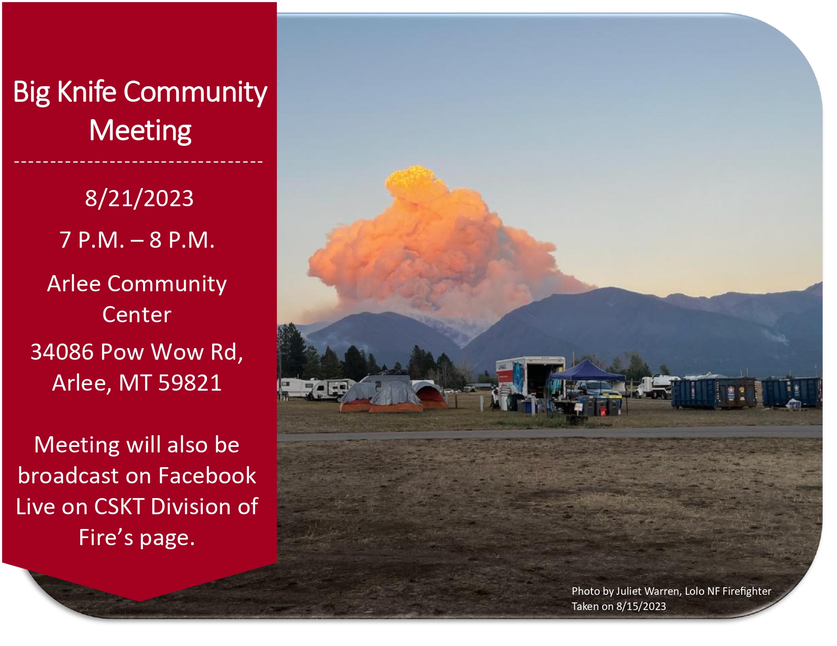
Community Meeting Tonight
Related Incident: Big Knife
Publication Type: Announcement
A community meeting with updates on the Big Knife Fire will be held at the Arlee Community Center at 34086 Pow Wow Rd., Arlee, MT on Monday, August 21 at 7:00 PM.

Big Knife Fire Update August 21 2023
Related Incident: Big Knife
Publication Type: News
Community Meeting Today
Arlee Community Center, 34086 Pow Wow Rd., Arlee, MT Monday, August 21st, 2023 at 7 P.M.
Meeting will be broadcast on CSKT Division of Fire Facebook Live
Active fire remains in tighter canopies where rain is unable to reach the ground. On the north edge of the fire along S. Canal Road, resources will continue to hold and improve containment lines. On the south end of the fire in the Agency Creek drainage, crews pulled up the hose lays and are patrolling and cooling hot spots within the fire perimeter. Near Jocko Lookout, the fire was creeping and smoldering, and rains wet the area. Crews will be completing a power line assessment.
The Big Knife Fire is currently 1.25 miles north of the Rattlesnake Wilderness Boundary (Lolo National Forest) with no significant growth towards the Lolo National Forest in the last week. Smoke from the fire may impact the Snowbowl area, however the Lolo National Forest does not have any forest closures in place on the Missoula Ranger District.
CLOSURES AND SPECIAL MESSAGES: Several areas near the base of the mountains west of the Big Knife Fire remain in PRE-EVACUATION WARNING by order of the Lake County Sheriff. See the map for those locations in yellow (Jocko, Canal, Francis). The Tribal Primitive Area, Belmore Slough and Burnt Cabin Roads are closed.
A PRE-EVACUATION WARNING means you may be in your home. Individuals in this status should not bring back evacuated livestock until the area is downgraded to READY status.
A temporary flight restriction (TFR) is in effect around the fire area. Do not fly unmanned aircraft (drones) near the fire areas.
Weather: Rain is expected all day today with up to a half inch of accumulation over the next several days. After 4:00 PM there is a chance of thunderstorms.
FIRE RESTRICTIONS: Stage 2 fire restrictions are in place across the Flathead Indian Reservation. No campfires are allowed, no smoking outside of vehicles, no operating combustible engines from 1 p.m. to 1 a.m., no operating vehicles off designated roads and trails. Stage 1 fire restrictions are in place in Granite County. The following are prohibited until rescinded: Building, maintaining, attending, or using a fire or campfire except within a developed recreation site or improved site. Smoking, except within an enclosed vehicle or building, a developed recreation site or while stopped in an area at least three feet in diameter that is barren or cleared of all flammable materials. Visit https://www.mtfireinfo.org/ for more fire restriction information across Montana.
Pogo Mine Road 191 Mount Hayes 299 Fires Update 8202023
Related Incident: Pogo Mine Road FireMount Hayes Fire
Publication Type: News
WILDFIRE UPDATE - Delta Area
Pogo Mine Road Fire (#191) & Mount Hayes Fire (#299)
Sunday - August 20, 2023
Firefighters work to cleanup heavy concentrations of downed trees and unburned fuels.
“Cold trailing” (using bare hands to feel for lingering traces of heat) is one of the final steps of mop up on any fire. To facilitate this process, any unburned surface fuels need to be removed. Firefighters are hard at work “bone piling” (stacking and burning) these fuels to remove them and clear the way for cold trailing, while weather conditions are favorable.
Pogo Mine Road Fire (#191) – 48,745 acres | 175 personnel | 12 miles NW of Delta
The UAS module continues to fly heat detection and reconnaissance missions. The structure protection group will be assessing Quartz Lake to help homeowners create defensible space around structures for the next few shifts. Chena Hotshots and Arroyo Grande Hotshots are moving to the southern tip of the fire to construct fire line around areas of unburned fuel. Franco Forestry and North Pacific fire continue to mop up around the portion of the fire that spotted over the Alyeska Pipeline. The Tongass Fire Suppression Module will be working up the western flank of the fire, breaking up concentrations of fuel along dozer lines and in pockets of downed timber.
Mount Hayes Fire (#299) – 6,720 acres | 23 personnel | 7 miles SE of Deltana
No growth on the fire over the last week. The fire is currently being monitored by air. Sierra Hotshots are implementing cabin protection in the Lisa Lake area. Donna & Little Donna Lake structure protection has been completed. Inventory and retrieval of surplus suppression equipment from the fire is ongoing.
Weather: Today winds will be from the southwest with some down sloping off the Alaska range, drying out the precipitation that is moving in from the northwest. Chances of rain will increase later in the day.
A Temporary Flight Restriction is in place for the fires, pilots please check NOTAMs.
Fire Information: Phone number: (907) 921-7852 / Fire Info website: AkFireInfo.com