
Spann Fire Daily Update August 21 2023
Related Incident: Spann Fire
Publication Type: News
Spann Fire Daily Update
August 21, 2023
11:30 am
Size: 500 acres
Containment: 75%
Start Date: August 20, 2023
Cause: Under Investigation
The Spann Fire was reported on August 20, 2022, at 12:35 pm 10 miles south of Center, Texas. The fire was spotted by an air detection aircraft west of U.S. Highway 96 and is spreading through timber and understory vegetation.
Multiple local fire departments, Texas A&M Forest Service (TAMFS), Texas Intrastate Fire Mutual Aid System (TIFMAS), and United States Forest Service (USFS), have returned to the scene to continue mop-up operations and improve containment lines. Aviation resources are ordered to provide additional assistance to dozers and engines. All agencies and local fire departments are continuing to work in unified command.
Hot and dry conditions will continue with wind speeds around 10-15 mph today. Temperatures are expected to reach over 100 degrees again with a relative humidity near 20-25%. A Red Flag Warning from the National Weather Service is in effect until 8 PM CDT for the area including the fire location. Fire resources will be monitoring the local area in support of local fire departments.
There is a Temporary Flight Restriction (TFR) in place for the area over the Spann Fire [NOTAM: FDC 3/8026, [https://tfr.faa.gov/save_pages/detail_3_8026.html]. Please avoid the area to provide a safe environment for firefighting aircraft.
Evacuations and Closures:
Evacuations have been ordered for the following areas: County Road 1021, County Road 1022, County Road 1015, and County Road 1026. Residents being evacuated should take all people and pets, personal items, prescriptions, important papers, and priceless items with them. Have enough of these necessary items to be out of the area for 24-48 hours.
Sourdough Fire Update August 21 2023
Related Incident:
Publication Type: News
Resources: 306 Total Personnel | 4 Hand Crews | 15 Engines | 5 Water Tenders | 7 Helicopters
(Newhalem, Wash.) -- The Sourdough Fire started with a lightning strike on July 29 near Diablo in the Ross Lake National Recreation Area, 7 miles northeast of Newhalem. Efforts on the Sourdough Fire, approximately 5,997 acres with 12% containment, continue to show significant progress. Firefighting teams have protected communities, crucial highways, and essential infrastructure. Most of the fire growth remains located in the remote northern terrain. With no safe access, these terrains highlight the importance of a strategic approach to fire management.
Yesterday: With the anticipated east winds, resources were strategically positioned to monitor fire activity on the southwestern portion of the fire perimeter, and no significant flare-ups were observed. Unmanned Aerial Systems (UAS) detected heat above the tunnel on State Route 20 near mile marker 124. The fire continues to shed debris. Firefighters monitored, mopped up, and safely cleared these materials from the roadway. The small 1/10th acre fire found yesterday east of Newhalem continues to be monitored, showing no additional heat signatures or growth. Due to limited visibility from smoke, helicopters could not assist in the Sourdough area yesterday, however, they were able to provide support for initial attack action on a new fire start near Darrington, WA — the Huckleberry Flats Fire.
Today: Heat was detected in the upper part of the Sourdough Creek drainage, which will be a focal point for aerial suppression operations. To ensure comprehensive coverage and monitoring containment lines along State Route 20, ground crews will work alongside UAS (drones) to monitor and patrol the area. Where the fire’s perimeter is secure, repair activities are underway.
Weather: Hot, dry and unstable atmospheric conditions continue today. A cold front will move through the area, bringing cooler temperatures and a slight chance of showers on Tuesday and Wednesday. Precipitation is expected to be minimal with limited effects on overall fire behavior.
Safety: Fire danger remains extremely high. The public can help prevent the next wildland fire by observing outdoor burning bans and avoiding other common ignition causes.
Smoke: Smoke from fires throughout the region is significantly affecting many communities. Information aboutcurrent conditions and a smoke forecast is located at: https://wasmoke.blogspot.com.
For information on how you can prepare for wildfire smoke, go to: https://www.cdc.gov/disasters/wildfires/smoke.html and https://www.wildlandfiresmoke.net/smoke-ready
Closures and Evacuations: State Route 20 remains closed between milepost 120 (Newhalem) and milepost 171 (Silver Star Campground). Trail, area and camp closures are in effect; for more information, go to: https://www.nps.gov/noca/planyourvisit/fire-closures.htm
Quartz Ridge Fire Daily Update Monday August 21
Related Incident: Quartz Ridge Fire
Publication Type: News
Quartz Ridge Fire
August 21, 2023
Fire start date: August 5, 2023
Cause: Lightning
Location: 13 miles Northeast of Pagosa Springs, Colorado
Incident Commander: Jay Kurth
Management Team: NIMO Team 1
Management: Suppression
Fire size today: 1,507 acres
Containment: 0%
Completion: 53%
Personnel: 145
Evacuation Information: There are no current evacuations. Local residents should follow incident information for updates.
Closures:
- Quartz Meadows Rd (NFSR#685)
- Quartz Ridge Trail (NFST#570)
- Quartz Creek Trail (NFST#571)
- https://tinyurl.com/roads-and-trails
Latest Smoke Outlook: https://outlooks.wildlandfiresmoke. net/outlook/933fc4e4
INCIDENT OBJECTIVES:
- Firefighter and Public safety are the highest priority.
- Protect private lands within East Fork San Juan River drainage, natural resources, cultural and historic sites, recreation assets, and critical infrastructure including powerlines and gas utility lines.
Smoke from the Quartz Ridge Fire was visible in Pagosa Springs and surrounding areas yesterday. This was prompted, as expected, by the hotter, drier weather. Limited fire growth occurred on the fire's southeast corner and on the east side of Quartz Creek. Today, firefighters will assess options for limiting further growth in those areas.
A Multi-Mission Aircraft flight was flown Sunday. Results from the flight showed most of the heat remains in the southeast corner of the Quartz Fire and within rocky terrain on the eastern side of Quartz Creek. The rocky terrain is limiting further growth.
The wildfire is burning in steep terrain in the South San Juan Wilderness. A combination of indirect and direct control lines is being utilized to accomplish multiple objectives of full suppression on accessible parts of the fire and confinement on parts that are remote and/or present high safety risks to firefighters. Overall, 53% of these objectives have been completed.
YESTERDAY’S ACCOMPLISHMENTS:
- Continued to evaluate terrain and potential areas for containment outside of wilderness boundaries and scouted for strategic areas for control.
- Pike hotshots hiked south toward the southeast corner with the intention of engaging the fire but drew back from the growing fire in the afternoon.
- Finished chipping the slash along the East Fork Road.
- Completed the containment of the hot spots on the northeast side of the fire.
TODAY’S PLAN:
- Assess the burned area on the east side of Quartz Creek for control features and strategies.
- Continue structure prep along East Fork Road at the Silver Guard Station.
WEATHER:
Today’s weather will have slightly higher humidity in the morning and a 30% of isolated thunderstorms in the afternoon. The temperatures will be in the high 70’s with 20 mph winds and gusts associated with the storms.
Incident Information : https://tinyurl.com/mr37bhnr
Facebook : https://tinyurl.com/y87cycm4
Email : 2023.quartzridge@firenet.gov
Information Line : 970-426-5370
Fire Update Elkhorn Fire August 21 2023
Related Incident: Elkhorn Fire
Publication Type: News
McCall, Idaho – The Elkhorn Fire is 26,048 acres and 68% complete. A Flood Watch is in effect through Tuesday evening due to near-record levels of atmospheric moisture associated with the remnants of Hurricane Hilary. Heavy rainfall (over an inch) is expected. For weather updates visit the National Weather Service Missoula Forecast Office https://www.weather.gov/mso/. Burn scars and flood-prone areas will be at risk for rock, mudslide, and debris flows. Learn how to prepare at https://www.ready.gov/floods.
The fire is creeping and smoldering in heavy dead and down timber. Suppression repair of mechanical line will continue as weather allows. Backhaul of structural protection equipment no longer needed from Whitewater Ranch downriver to China Bar is complete. Removal of equipment upriver will begin after the forecasted weather event.
Communication continues with the boaters entering the river at Corn Creek and again at Hancock Rapids before entering the fire footprint along the river corridor. Fire activity has significantly altered the landscape on both sides of the river in the area of the Elkhorn Fire. Be on the lookout for falling rocks, logs, and other debris. Please exercise caution when floating through the fire area. Heavy rains on burned areas may create new river hazards and rapids. Boaters are required to stop at Hancock Campsite on river-left, at river mile 26.1 to receive further instruction via a river information board regarding passing through and camping in the area of the Elkhorn Fire. Please read the river information board for any changes that may have occurred since you left Corn Creek launch. Camping, recreating (i.e., picnic, bathroom breaks and beach walking) and stopping through the area of Elkhorn fire activity is allowed with some exceptions. Once past Hancock Camp (River Mile 26.1) there is no stopping until boaters pass Magpie Creek Camp (River Mile 29.6). After passing Magpie Creek Camp, boaters will be allowed to camp and recreate on a First Come, First Served basis everywhere except Upper Allison, Allison, Lower Allison, and Whitewater Camp. After passing Whitewater Ranch (River Mile 39) there are no restrictions connected to the Elkhorn Fire. For additional information on rafting, contact the river desk at 208-756-5587 or 208-481-2625.
The U.S. Forest Service Nez Perce-Clearwater and Payette National Forests issued the Elkhorn fire area, roads and trails closure order #01-17-05-23-003, https://www.fs.usda.gov/alerts/nezperceclearwater/alerts-notices/?aid=82169 that spans both sides of the Salmon River but excludes the Salmon River Wild and Scenic Corridor below the high-water line.
A Temporary Flight Restriction (TFR) is in place for a two-mile buffer around the fire perimeter. All aircraft (including drones) not assigned to the fire are required to remain out of the TFR area between 0900-2100.
Fire info and daily air quality updates are available on InciWeb https://inciweb.nwcg.gov/incident-information/idpaf-elkhorn-fire and the Payette National Forest Facebook https://www.facebook.com/payettenationalforest.
Little Mesa Fire Update August 21 2023
Related Incident: Little Mesa Fire
Publication Type: News
Little Mesa Fire Update
Monday, August 21, 2023
Location: Approx. 15 miles west, southwest of Delta, CO, Dominguez Escalante National Conservation Area
Discovered: July 31, 2023, 11:00 AM
Cause: Lightning
Estimated Size: 3,896 acres
Vegetation Type: Pinyon, Juniper, sagebrush, grass
Containment: 30%
Total Personnel: 35
NOTICE TO THE PUBLIC: Air operations may be conducted on the Little Mesa Fire. For your safety, please stay out of the Potholes Recreation Area. The helicopters are using this water source for fire suppression.
Current Situation: The fire saw no new growth yesterday. Firefighters made great progress in securing the fire edge, along with patrolling the area for threats to the fire line. With firefighter vigilance the fire held within the established containment areas throughout the day despite the windy hot conditions. Pockets of unburned vegetation deep in the fire’s interior actively burned and produced visible smoke. Lightning from previous days’ storms ignited many small fires in the region. Air resources and engines are being used to detect, locate, and contain these new starts.
Throughout the day firefighters will continue to patrol and extinguish heat along the fire perimeter. Smoke might continue to be seen as fire creeps into islands of unburned vegetation causing flare ups within the fire interior.
Weather: An increase of precipitation is expected for western Colorado. Though gusty winds will be widespread across the region, critical fire weather conditions are not expected due to the higher relative humidities today. Isolated showers and thunderstorms are possible in the afternoon. Mostly sunny today with temperatures in the high 80s and south winds 12 to 20 mph with gusts to 30 mph in the afternoon. Shower and thunderstorm coverage increases Tuesday and through the end of the week as monsoonal moisture and remnants of Tropical Storm Hilary filter into the region.
Evacuations and Closures: No evacuations have been issued. Temporary road closures are in place in Delta County on Dry Mesa Rd at the intersection with Escalante Rim Rd and on USFS Dry Mesa Rd at Sawmill Mesa Rd junction. The GMUG National Forests have issued a forest closure order for the area around the Little Mesa Fire. Public access to the closure area is limited. Visit https://bit.ly/3YwXNz0 for more information.
Smoke: Smoke is visible from surrounding areas and highways 50, 550, 92, 65, 141 and C37 Road. Go to fire.airnow.gov or colorado.gov/airquality/ to get updates on smoke conditions.
Aviation Safety: Incident aircraft may be flying over the Little Mesa Fire air space. Fire aviation resources are flying at different altitudes and speeds. Unmanned aircraft systems (UAS) or drones must never fly near wildfires. Remember if you fly, we can’t!
For updated information follow on these outlets:
Inciweb: https://inciweb.wildfire.gov/incident-information/coupd-little-mesa-fire
Facebook: @LittleMesaFire Twitter: @SWD_Fire
Closure Order Update Black Feather Fire Closure Order August 21 2023
Related Incident: Black Feather Fire
Publication Type: Closures
UNITED STATES DEPARTMENT OF AGRICULTURE
U.S. FOREST SERVICE SANTA FE NATIONAL FOREST
COYOTE and CUBA RANGER DISTRICTs
BLACK FEATHER FIRE AREA, ROAD, AND TRAIL CLOSURE
PROHIBITIONS
Pursuant to 16 U.S.C. § 551 and 36 C.F.R. § 261.50(a) and (b), the following are prohibited on the National Forest System (NFS) lands, roads, and trails in the Coyote and Cuba Ranger Districts, Santa Fe National Forest, described below and shown on the attached map incorporated into this Order as Exhibit A (the “Described Area/Roads/Trails”):
1. Going into or being upon the Described Area. 36 C.F.R. § 261.53(e).
2. Being on the Described Roads. 36 C.F.R. § 261.54(a).
3. Being on the Described Trails. 36 C.F.R. § 261.55(a).
EXEMPTIONS
Pursuant to 36 C.F.R. § 261.50(e), the following persons are exempt from this Order:
1. Persons with Forest Service Permit No. FS-7700-48 (Permit for Use of Roads, Trails, or Areas Restricted by Regulation or Order), specifically exempting them from this Order or a written determination by a Forest Service authorized officer that a permit is not required under 36 C.F.R.§ 251.50(e)(1) or (2).
2. Any Federal, State, or Local Officer, or member of an organized rescue or firefighting resource in the performance of an official duty.
3. Landowners who need to cross NFS lands or roads in the closure area in order to access their private property.
DESCRIBED AREA/ROADS/TRAILS
The Described Area is within Township 22 North, Range 2 East, Sec. 29 and 32; Township 21 North, Range 2 East, Sec. 5; Township 22 North, Range 2 East, Sec. 32 and 33; Township 21 West, Range 2 East, Sec. 4, 7, 9, 16, 17 and 18; Township 21 West, Range 1 East, Sec. 1 and 12; Township 22 North, Range 1 East, Sec. 25, 26, 35, and 36; Township 22 North, Range 2 East, Sec. 29, 30.
The Described Area includes all National Forest System lands within the following area: beginning at Corralitos trailhead (#452) at Resumidero campgrounds, following Forest Road (FR) 93 for 5.5 miles in a southerly direction; then in a south-southwesterly direction for 1.5 miles to FR 70; then following FR 70 in a westerly direction for 0.35 miles to Penas Negras trailhead (#32); then following Penas Negras trail (#32) in a northerly direction for 7.1 miles to the junction of Penas Negras trail (#32) and Rio Puerco Trail (#385); then following Rio Puerco trail for 0.3 miles in an easterly direction; then leaving the Rio Puerco trail (#385) and traveling in an easterly direction for 0.7 miles to Oso Creek; then following Oso Creek in an easterly direction for 2.25 miles to Corralitos Trail (#452); then following Corralitos trail (#452) for 1.4 miles to the
trailhead at Resumidero Campground (1.4 miles).
• Penas Negras Trail # 32 within the San Pedro Parks Wilderness is closed. Corralitos Trail # 452 is used to delineate the closure.
PURPOSE
The purpose of this Order is to protect public health and safety and the safety of all personnel working the fire.
IMPLEMENTATION
1. This Order shall be in effect from August 21, 2023, at 8:00 a.m. through December 31, 2023, at 12:00 a.m., unless rescinded.
2. A map identifying the Described Areas/Roads/Trails, is attached, and made part of this Order as Exhibit A. For a digital version of this Order and Exhibit A, go to https://www.fs.usda.gov/alerts/santafe/alerts-notices.
3. Unless otherwise expressly defined in this Order, the terms used in this Order are defined by the regulations of the Secretary of Agriculture, 36 C.F.R. Chapter II, Parts 200-299. If there are terms in this Order that are not expressly defined in the Order or 36 C.F.R. Chapter II, Parts 200-299, their meaning shall be determined by their plain language definitions.
4. A violation of the above prohibitions is punishable as a Class B misdemeanor by a fine of not more than $5,000 for individuals and $10,000 for organizations, or by imprisonment for not more than six months, or both. 16 U.S.C. § 551; 18 U.S.C.§§ 3559, 3571, and 3581.
5. Contact the Coyote Ranger District in Coyote, (575) 638-5526, or the Cuba Ranger District in Cuba, (575) 289-3264 and Santa Fe National Forest Supervisor’s Office in Santa Fe, (505) 438-5300, for more information about this Order.
6. This Order supersedes any previous Orders prohibiting the same or similar acts on the same Described Areas/Roads/Trails.
Signed and issued on 19 day of August 2023.
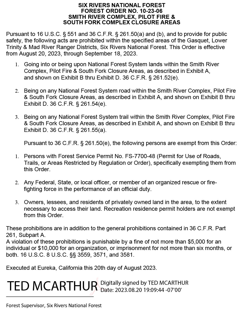
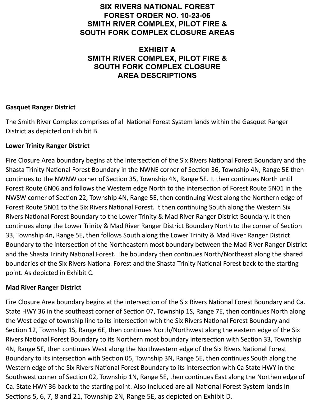
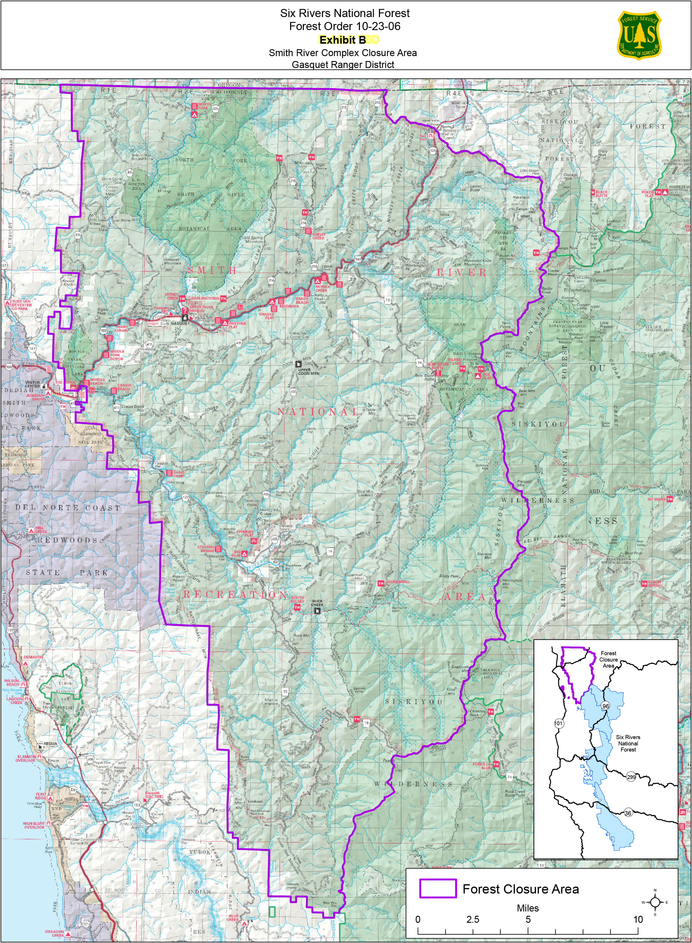
Forest Order No 102306 8212023
Related Incident: Smith River Complex
Publication Type: Closures
Forest Order No. 10-23-06 – SMITH RIVER COMPLEX, PILOT FIRE &
See attached.
Thompson Ridge Fire Update Aug 21 2023
Related Incident: Thompson Ridge Fire
Publication Type: News
Thompson Ridge Fire Update
Monday, August, 21, 2023
FIRE SITUATION
There is a flash flood warning in effect throughout south central Utah until midnight on Tuesday, August 22nd. Please be prepared for rapidly changing conditions.
Yesterday, on the southeast corner of the fire, crews completed suppression repair work on dozer lines. Resource advisors began planting seed to take advantage of the current wet weather.
Today, crews continue to patrol and check containment lines on the Thompson Ridge Fire. They will work to repair spike camps and clean up from the previous weeks of firefighting efforts. Spotty rain and gusty winds are expected, but continued relative humidity recovery should keep fire behavior to a minimum and within containment lines.
The incoming Incident Commander and fire operations personnel are touring the fire with current staff to pass on information and situational awareness as they prepare to take command of the fire.
Tomorrow, Tuesday, August 22nd, Great Basin Team 5 will hand command of the fire back to the Fishlake National Forest.
CLOSURES
An updated closure order will go into effect on Tuesday, August 22nd and should be online at https://www.fs.usda.gov/detail/fishlake/alerts-notices soon. Use caution in formerly closed areas, as there may still be firefighting equipment accessing the perimeter along these roads.
STATUS
Start Date: August 4, 2023
Incident Type: Wildfire
Size: 7,253 acres
Cause: Lightning
Containment: 85%
Location: 10 miles southeast of Beaver, Utah
Terrain: Steep, rugged terrain in remote areas transitioning to rolling pinyon juniper hills
Structures Threatened: None
RESOURCES
Engines: 4
Water Tenders: 1
Crews: 1
Helicopters: 4
Dozers: 1
Total Personnel: 194
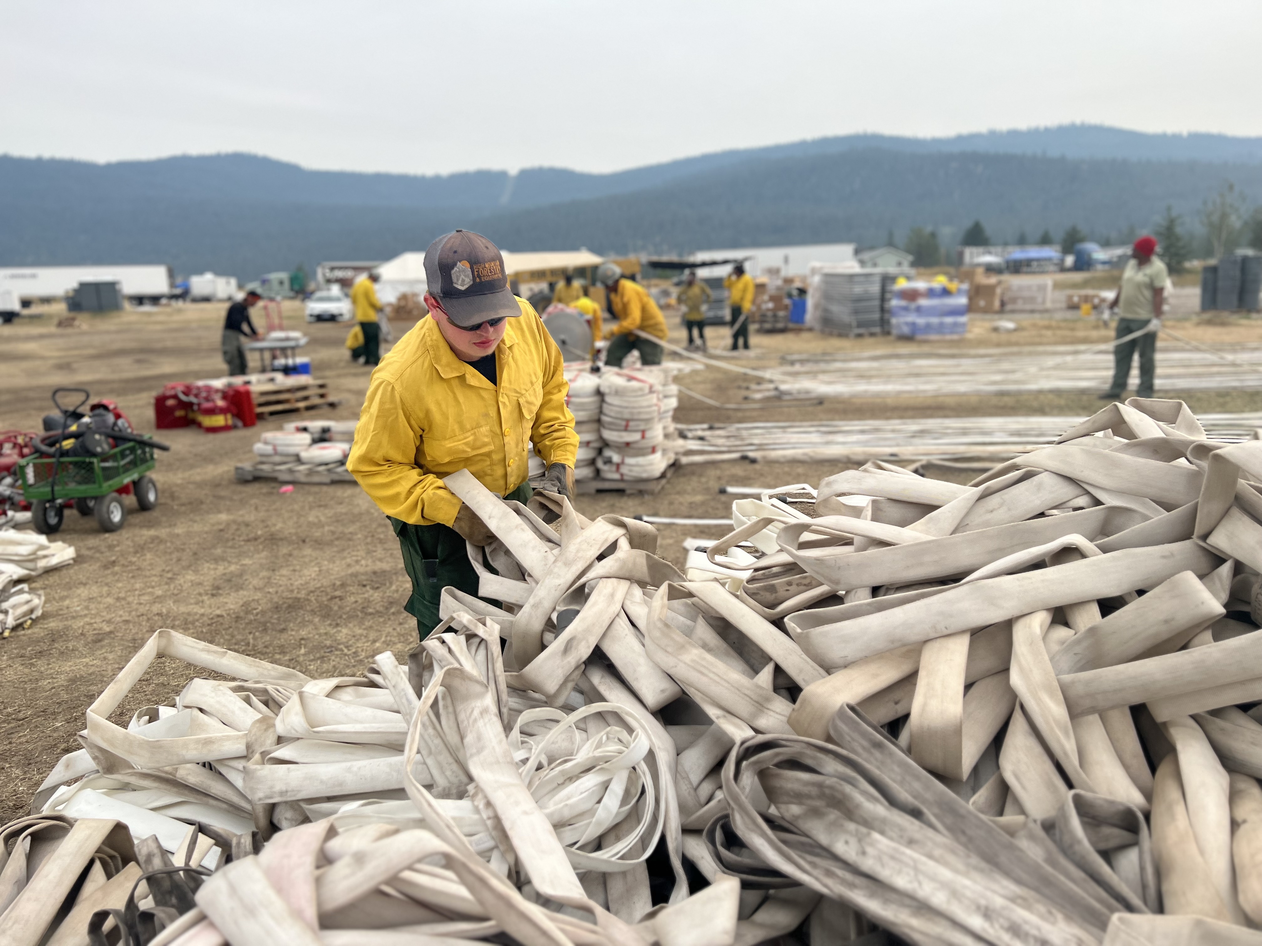
Niarada and Mill Pocket update for August 21 2023
Related Incident: Niarada
Publication Type: News
Firefighters on the Niarada Fire worked to backhaul excess gear and equipment Sunday as the fire moves into suppression repair mode.
Crews hauled hose, pumps, tanks and equipment as fire managers work to thin personnel numbers in the coming days and send resources to other fires that might have greater needs.

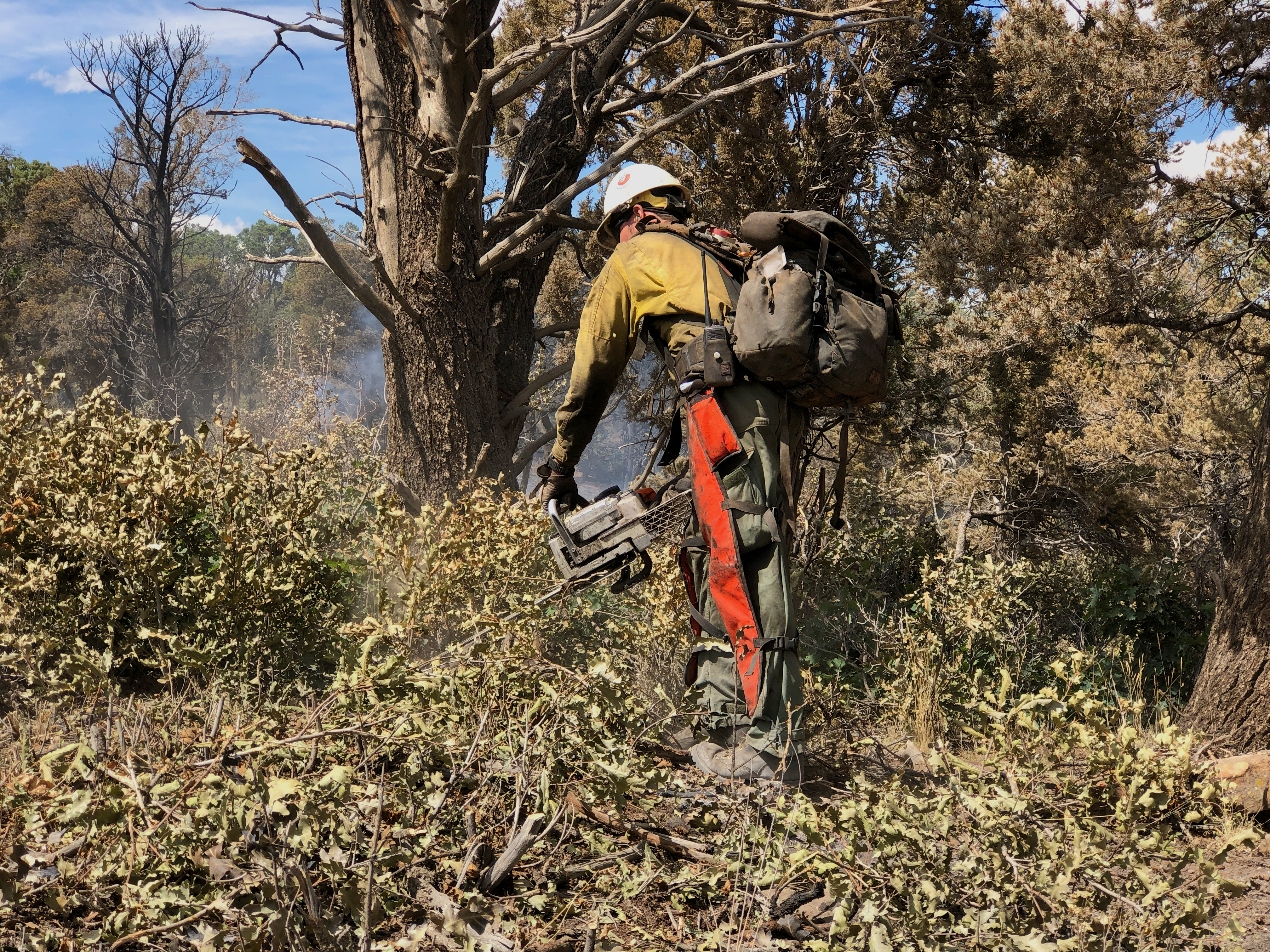
Control lines have been tested through high wind and extreme heat but now must be put back to as natural a state as possible. Hand crews, road graders, bulldozers and excavators will be used to repair and rehab areas that were impacted in efforts to stop the fire’s spread. These suppression repair efforts include chipping or stacking limbs and brush that was cut to widen roads, rehabbing and covering dozer lines, and grading roads among other things in order to leave the sight as naturalized as possible before personnel depart.
The Mill Pocket Fire is 100% contained with little suppression repair left to complete.
WEATHER AND FIRE BEHAVIOR
Showers and thunderstorms are forecast today and Tuesday with winds remaining calm. Precipitation amounts from a quarter to half an inch are predicted for today and another tenth of inch Tuesday.
CLOSURES AND SPECIAL MESSAGES
The Lake County Sheriff's office in consultation with the Niarada fire team lifted the pre-evacuation warning. All residents may bring their livestock back home.
The temporary flight restriction (TFR) has been lifted, as well. That said, do not fly unmanned aircraft (drones) near ANY fire area under any circumstance. Drones are hazardous for pilots, and the firefighters on the ground who rely on aircraft support. Remember, if you fly, we can’t!
FIRE RESTRICTIONS
Stage 2 fire restrictions are in place across the Flathead Indian Reservation as well as Lake, Flathead and Sanders counties. No campfires are allowed, no smoking outside of vehicles, no operating combustible engines from 1 p.m. to 1 a.m., no operating vehicles off designated roads and trails. Residents and visitors are encouraged to visit www.MTFireInfo.org for more fire information across Montana.
Fire Information: 406-647-0446 | 2023.Niarada@firenet.gov
Location: Niarada - 12 miles west of Elmo, MT | Mill Pocket: 3 miles West of Hwy. 28
Start Date: Niarada - 7/30/2023 | Mill Pocket – 7/30/2023 Cause: Lightning Structures Damaged: 4
Acres/Containment: Niarada–20,365 acres, 95% contained | Mill Pocket– 1,869 acres, 100% contained
Total Personnel: 130 total Engines: 4 Aircraft: Available as needed Hand Crews: 2
Ridge Doris Point and Tin Solider Daily Fire Update for August 21 2023
Related Incident:
Publication Type: News
Ridge, Doris Point, and Tin Solider Daily Fire Update for August 21, 2023
Fire Information: 406-998-6074
Hours: 8:00 AM – 7:00 PM
Email: 2023.ridge@firenet.gov
Incident Website: Ridge Fire: http://inciweb.wildfire.gov/incident-information/mtfnf-ridge-fire
Tin Soldier: https://inciweb.nwcg.gov/incident-information/mtfnf-tin-soldier-complex
Ridge Fire:
Location: 6 miles southeast of Hungry Horse
Size: 3651 acres
Percent Contained: 39%
Cause: Lightning
Start Date: July 30, 2023, 3:45 PM
Number of Personnel Assigned: 596
Doris Point Fire:
Location: 8 miles south of Hungry Horse
Size: 1534 acres
Percent Completion: 0%
Cause: Lightning
Start Date: July 30, 2023, 3:45 PM
Number of Personnel Assigned: 15
Tin Soldier:
Location: 17 miles east of Swan Lake
Size: 7697 acres
Percent Completion: 0%
Cause: Lightning
Start Date: July 30, 2023, 3:45 PM
Number of Personnel Assigned: 132
CURRENT SITUATION:
Ridge Fire: Yesterday, crews on the western and northern area of the fire continued to mop up and back haul excess equipment. Drop points in these areas were cleaned up and crews prepared for rain. On the northeastern edge, firefighters contained a few spot fires and were able to get control lines around them. To the southeast, mop up also continued. Today, crews will continue mop up activities and install control lines where appropriate to prevent fire spread to the north and east. Aviation will be utilized today as weather and winds allow.
Doris Point Fire: Crews will continue to maintain confinement, and point protection strategy on the values at risk in coordination with the Flathead National Forest. Crews will continue fuels reduction and structural prep, as well as setting up pump sprinklers.
Tin Soldier Fire: Yesterday, crews mopped up an area where fire had crossed the Meadow Creek Road and there are currently no further issues in this area. Crews will continue to maintain point protection strategy on the values at risk in coordination with the Flathead National Forest. Crews will continue fuels reduction and structural prep, as well as setting up pump sprinklers.
WEATHER:
Deep moisture associated with the remnants of Hurricane Hilary will move across the Northern Rockies today, bringing widespread rain by this afternoon, which may be moderate to heavy at times late this afternoon into this evening. Rain looks to diminish Tuesday morning, but additional moisture circulating through the area will maintain some showers through Tuesday evening.
Ridge & Doris Point: 70-75 degrees in the lower elevations and 64-69 degrees in the mid-slopes to ridges. 46-51% minimum relative humidity and winds east up 7 mph with gusts to around 15 mph on the ridgetop.
Tin Soldier: 68-73 degrees in the lower elevations and 62-67 degrees in the mid-slopes to ridges. 46-51% minimum relative humidity and winds east 5 to 10mph with gusts around 18 mph on the ridgetop.
RIDGE & DORIS FIRE PRE-EVACUATION NOTICE:
The Flathead County Sheriff’s Office has issued a pre-evacuation notice from the east side of Spotted Bear Road to West Glacier. Visit the Flathead Sheriff’s office for details https://www.facebook.com/flatheadsheriff
EMERGENCY SHELTER:
The American Red Cross has identified the following location as an emergency shelter for residents affected by the Ridge Fire. Those who plan to use the emergency shelter are asked to call 1-800-733-2767 prior to your arrival.
Columbia Falls Junior High School 1805 Talbot Road Columbia Falls, MT https://www.facebook.com/FlatheadOES
TIN SOLDIER FIRE EVACUATIONS, CLOSURES AND RESTRICTIONS
An evacuation has been issued by the Flathead County Sheriff for Heinrude community. Visit the Flathead Sheriff’s office for details https://www.facebook.com/flatheadsheriff
FIRE CLOSURES:
The Hungry Horse Reservoir is closed to all public access, including both the east and west side roads. As firefighting efforts continue on the Ridge Fire, the Tin Soldier, and other fires in the area, the closure is in place to provide for public and firefighter safety. https://www.fs.usda.gov/alerts/flathead/alerts-notices/?aid=82283
ADDITIONAL INFORMATION:
Residents should stay alert for changing conditions and visit ready.gov/wildfires for preparing for wildfires. Please refer to http://inciweb.wildfire.gov/incident-information/mtfnf-tin-soldier-complex for the Tin Soldier Complex Incident information