
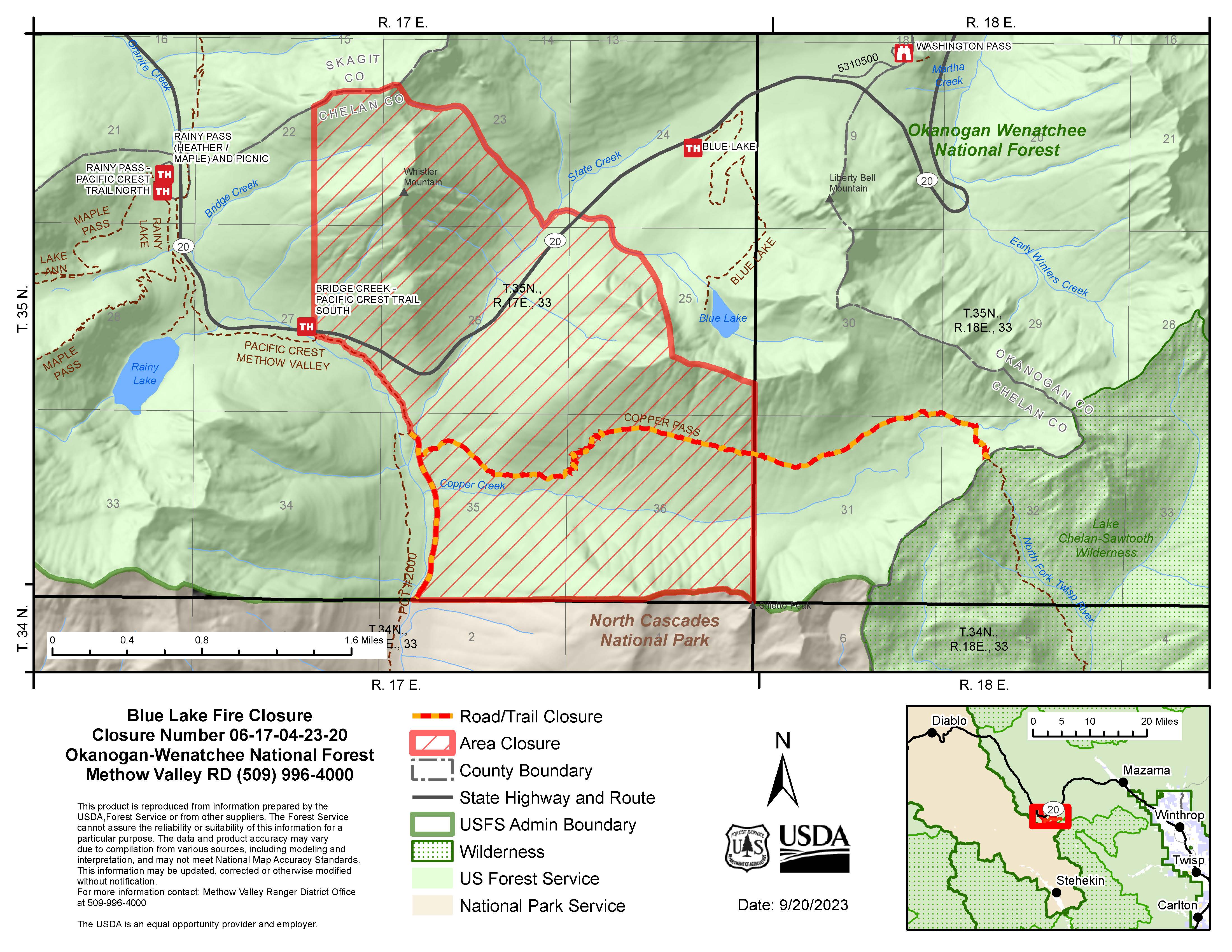
Blue Lake Fire Closure Order Updated
Related Incident: Blue Lake Fire
Publication Type: Closures
Closure Order: 06-17-04-23-20
Black Feather Fire Daily Update August 22 2023
Related Incident: Black Feather Fire
Publication Type: News
Update: August 22, 2023, Continuing to Suppress and Repair on the Black Feather Fire
Acres: 2,198 acres
Start Date: August 5, 2023
Cause: Lightning
Fuels: Timber, Brush, Understory
Containment: 28%
Resources: 126 personnel
Location: Approximately 9 miles south of Gallina, NM, on the Santa Fe National Forest, Coyote Ranger District. Near the Peñas Negras Trail in the San Pedro Parks Wilderness.
Highlights: Resources have moved into a more direct attack due to decrease in current fire behavior and in order to mitigate threats to values at risk. In switching to more direct attack, prior hazards have been mitigated. Crews are utilizing UAS (unmanned aircraft system) with infrared capabilities in order to mitigate exposure. Suppression repair work will continue, graders will be performing the necessary work according to the suppression repair plan across the fire area. Hotshot crews were able to reach portions of the fire within the wilderness, locating areas of more active fire and scouting locations that can safely be accessed for future suppression activities. Crews outside of the wilderness finalized chipping operations and continued to work on containment lines along the eastern edge of the fire.
Operations: Today, suppression efforts will continue within the wilderness and along the eastern edge of the fire. Crews will utilize an infrared drone to help identify areas with greater fire activity and focus their efforts on those locations. With heavy dead and down with dead standing timber in the wilderness, fire managers are carefully monitoring suppression activities in relation to weather and fire behavior to ensure incident objectives are met while remaining focused on firefighter safety.
Safety: Equipment and fire crews are actively moving in and around the fire area, including roads reopening today. Please use caution when traveling around the Black Feather Fire. The Temporary Flight Restriction is still in place. Please do not fly drones anywhere near the fire. If you fly, we can’t fly.
Weather: Weather will improve through the evening as winds taper off and temperatures cool. A few more hours of near critical conditions are possible Monday across the Four Corners. Southeast winds will still be breezy but lighter than today. The remainder of this week will see improving moisture each day with more showers and storms especially toward the end of the week.
Restrictions/Closures: Effective Monday, August 21, the Santa Fe National Forest has issued an updated area, road, and trail closure in part of the Coyote Ranger District. https://www.fs.usda.gov/alerts/santafe/alerts-notices/?aid=82261 for information and a corresponding map. Forest Road 103 is now open. Closures will be adjusted based on fire activity.
Smoke: Variations in temperatures, humidity & fire activity will impact smoke conditions in the coming days and weeks. Smoke may be more and less visible in the area as active smoldering takes place. Smoke-sensitive individuals and people with respiratory problems or heart disease are encouraged to take precautionary measures. Air quality information is available at https://www.airnow.gov/.
Evacations: The communities of Mesa Pinabetal, Mesa Poleo, and Wetherill remain in ‘Ready’ status. The Coyote Senior Center is open to evacuees, and livestock can be taken to the Rio Arriba Rural Event Center near Abiquiu. The Rio Arriba County Sheriff’s Office will coordinate evacuations if they go into effect. For more information, visit their Facebook page at https://www.facebook.com/profile.php?id=100079688263048
Fire Information: 505-460-0499 – 2023.blackfeather@firenet.gov
Facebook: https://www.facebook.com/blackfeatherfireinfo
New Mexico Fire Information: https://nmfireinfo.com/
Quartz Ridge Fire Daily Update August 22 2023
Related Incident: Quartz Ridge Fire
Publication Type: News
Fire start date: August 5, 2023
Cause: Lightning
Location: 13 miles Northeast of Pagosa Springs, Colorado
Incident Commander:
Jay Kurth
Management Team:
NIMO Team 1
Management: Suppression
Fire size today: 1,663 acres
Containment: 0%
Completion: 53%
Personnel: 145
Evacuation Information:
There are no current evacuations. Local residents should follow incident information for updates.
Closures:
-
Quartz Meadows Rd (NFSR#685)
-
Quartz Ridge Trail (NFST#570)
-
Quartz Creek Trail (NFST#571)
INCIDENT OBJECTIVES:
-
Firefighter and Public safety are the highest priority.
-
Protect private lands within East Fork San Juan River drainage, natural resources, cultural and historic sites, recreation assets, and critical infrastructure including powerlines and gas utility lines.
Smoke from the Quartz Ridge Fire was visible in Pagosa Springs and surrounding areas Sunday but less so on Monday. Sunday’s fire behavior burned an additional 188 acres and the fire crossed to the east side of Quartz Creek. There was limited growth on the fire Monday due to more favorable weather and lower fire intensities.
The wildfire is burning in steep terrain in the South San Juan Wilderness. A combination of indirect and direct control lines is being utilized to accomplish multiple objectives of full suppression on accessible parts of the fire and confinement on parts that are remote and/or present high safety risks to firefighters. Overall, 53% of these objectives have been completed.
The Multi-Mission Aircraft did not fly yesterday.
YESTERDAY’S ACCOMPLISHMENTS:
-
Continued to evaluate terrain and potential areas for containment outside of wilderness boundaries and scouted for strategic areas for control.
-
Assessed the burned area on the east side of Quartz Creek for control features and strategies.
-
Initiated structure prep along the East Fork Road at the Silver Guard Station.
TODAY’S PLAN:
-
Assess the burned area on the east side of Quartz Creek and the northern edge for control features and strategies.
-
Continue structure prep along East Fork Road at the Silver Guard Station.
WEATHER:
Today’s weather will be similar to yesterday with higher humidity's in the morning and a 30% chance of isolated thunderstorms in the afternoon. The temperatures will be in the high 70’s with 20 mph winds and gusts associated with the storms. Rain is predicted for Thursday.
East Fork Fire August 22 2023 UPDATE
Related Incident: East Fork Fire
Publication Type: News
NORTHERN ROCKIES TEAM 6
INCIDENT COMMANDER: Paul Roose
East Fork Fire - Daily Update - August 22, 2023
Kootenai National Forest/Flathead National Forest
Fire Information 406-285-8634 Eastforkfireinfo@gmail.com
https://inciweb.nwcg.gov/incident-information//mtknf-east-fork-fire
August 22, 2023
Location: 12 miles south of Trego, MT
Start Date: 7/30/2023 Cause: Lightning Size: 4,614 acres* Containment: 5%
Total Personnel: 498 Engines: 16 Hand Crews: 10
Yesterday’s Events: Cool, wet weather was a welcome relief to our firefighters. Because of the reduced fire behavior, crews were able to move in closer to the active fire and strengthen existing lines. Overcast, smoky conditions prevented the use of aircraft for the day. On the fire, approximately ½ inch of rain fell overnight.
Plans for Today: Field Operations Chief Danny Lemer stated at the morning briefing, “Today we have an opportunity to work with the weather.” With reduced fire activity, crews will work toward building a continuous fireline across the northern edge of the fire. On the eastern part of the East Fork Fire, heavy equipment will be used to open up roads. Burned and/or weakened trees will be removed to improve firefighter safety and to keep roads open for future actions.
Evacuations: Some communities remain in a Pre-Evacuation Warning. Residents may return to their homes under a Pre-Evacuation Warning, but may need to leave again on short notice. For more information, go to the Sheriff’s Department website.
Public Meetings: A public meeting is scheduled for 7:30 PM today at the Olney-Bissell School.
*Updated acreage information was not available because an IR (infrared) flight did not occur.
August 22 2023 Colt Fire Fact Sheet Update
Related Incident:
Publication Type: News
Current
Throughout the Colt Fire area, an average of ¾ inch rain fell yesterday.
Patrol and monitoring are ongoing.
In anticipation of higher containment, suppression repair and rehabilitation plans are continuing.
Forest Service closures are still in effect around the fire area. For your safety and the safety of fire
crews, please do not violate closure orders. Know before you go.
Outlook
Moisture from Hurricane Hilary is expected to remain in the area for the next couple days, with a
chance of Thunderstorms.
High temperatures are forecast in the mid‐70s for Swan Valley, and a little cooler at the ridgetops.
Firefighters will engage in mop up activities, as weather allows.
Closures
The Lolo National Forest has lifted the closure of the following:
Rainy Lake Campground and access road
Alva Lake Campground and access road
All other Forest closures remain in place, including Lakeside Campground.
Specific closure information can be found at
https://inciweb.wildfire.gov/incident‐information/mtmts‐colt‐fire
Final update for Niarada and Mill Pocket fires August 22 2023
Related Incident: Niarada
Publication Type: News
FINAL UPDATE ON THE NIARADA AND MILL POCKET FIRES
Barring any significant developments, this will be the final update for these fires. Both the Niarada Fire and Mill Pocket Fire are 100% contained.
Heavy equipment and hand crews continued suppression repair Monday but rain and deteriorating conditions made progress difficult. Crews, road graders, bulldozers and excavators will continue to repair and rehab areas that were impacted in efforts to stop the fire’s spread. These suppression repair efforts include chipping or stacking limbs and brush that was cut to widen roads, rehabbing and covering dozer lines, and grading roads among other things in order to leave the sight as naturalized. There is an estimated 7-10 days of work left and CSKT Division of Fire personnel will take command of the operation Thursday morning.
Control lines have been tested through high wind and extreme heat with no threat of escape remaining. That said, there still is minimal fire within the interior of the fire’s footprint and as the rain passes and fuels dry out, the sight of smoke and possible small, creeping fire is likely. It will take a season-ending event such as snow to truly put these fires out for good.
WEATHER AND FIRE BEHAVIOR
Rain is likely today and Wednesday with thunderstorms possible. A drying trend is forecast the rest of the week and into the weekend. There still is minimal fire within the interior and as the rain passes and fuels dry out, smoke and possible small, creeping fire is possible. It will take a season-ending event such as snow to truly put these fires out for good.
CLOSURES AND SPECIAL MESSAGES
The Lake County Sheriff's office lifted the pre-evacuation warnings related to the Niarada Fire. All residents may bring their livestock back home.
The temporary flight restriction (TFR) has been lifted, as well. That said, do not fly unmanned aircraft (drones) near ANY fire area under any circumstance. Drones are hazardous for pilots, and the firefighters on the ground who rely on aircraft support. Remember, if you fly, we can’t!
FIRE RESTRICTIONS
Stage 2 fire restrictions are in place across the Flathead Indian Reservation as well as Lake, Flathead and Sanders counties. No campfires are allowed, no smoking outside of vehicles, no operating combustible engines from 1 p.m. to 1 a.m., no operating vehicles off designated roads and trails. Residents and visitors are encouraged to visit www.MTFireInfo.org for more fire information across Montana.
Location: Niarada - 12 miles west of Elmo, MT | Mill Pocket: 3 miles West of Hwy. 28
Start Date: Niarada - 7/30/2023 | Mill Pocket – 7/30/2023 Cause: Lightning Structures Damaged: 4
Acres/Containment: Niarada–20,365 acres, 100% contained | Mill Pocket– 1,869 acres, 100% contained
Total Personnel: 130 total Engines: 4 Aircraft: Available as needed Hand Crews: 1
Ridge Doris Point and Tin Solider Daily Fire Update for August 22 2023
Related Incident:
Publication Type: News
Ridge, Doris Point, and Tin Solider Daily Fire Update for August 22, 2023
Email: 2023.ridge@firenet.gov
Incident Website:
Ridge Fire: http://inciweb.wildfire.gov/incidentinformation/mtfnf-ridge-fire
Tin Soldier: https://inciweb.nwcg.gov/incidentinformation/mtfnf-tin-soldier-complex
Ridge Fire
Location: 6 miles southeast of Hungry Horse
Size: 3651 acres
Percent Contained: 62%
Cause: Lightning
Start Date: July 30, 2023, 3:45 PM
Number of Personnel Assigned: 544
Doris Point Fire:
Location: 8 miles south of Hungry Horse
Size: 1534 acres
Percent Completion: 10%
Cause: Lightning
Start Date: July 30, 2023, 3:45 PM
Number of Personnel Assigned: 15
Tin Soldier:
Location: 17 miles east of Swan Lake
Size: 7697 acres
Percent Completion: 0%
Cause: Lightning
Start Date: July 30, 2023, 3:45 PM
Number of Personnel Assigned: 148
Fire Information: 406-998-6074
Hours: 8:00 AM – 7:00 PM
CURRENT SITUATION:
Rain fell across the Ridge, Doris Point, and Tin Soldier Fires yesterday aiding firefighters by moderating the fire activity. A team transition is scheduled to transfer command of the fires from California Interagency Incident Management Team 4 to Southwest Area Incident Management Team 1 tomorrow at 6:00 am.
Ridge Fire: Yesterday, crews on the western and northern area of the fire continued to address areas of heat, mop up, and back hauled excess equipment. Drop points in these areas were cleaned up and crews are preparing for more rain. On the northeastern edge, firefighters monitored yesterday’s spot fires and the control lines around them and worked areas of heat. Heavy equipment will be constructing indirect line through dense vegetation. To the southeast, mop up continued. Today, crews will continue mop up activities and install control lines where appropriate to prevent fire spread to the north and east. Aviation will be utilized if the weather and winds allow.
Doris Point Fire: Crews are maintaining confinement, and point protection strategy on the values at risk in coordination with the Flathead National Forest. Crews will continue fuels reduction, structural prep, setting up pumps, sprinklers, and wrapping structures and signs.
Tin Soldier Fire: Yesterday, crews held and secured Meadow Creek Road. Crews will maintain point protection strategy on the values at risk in coordination with the Flathead National Forest. Crews will continue fuels reduction and structural prep, setting up pumps, sprinklers, and wrapping structures and signs.
WEATHER:
Steady rain has ended but elevated moisture lingering across the area will result in the development of showers and thunderstorms at times today, especially this afternoon and evening. The unusually high moisture content will support heavy downpours with some showers and all thunderstorms that develop today. Brief heavy rainfall rates with storms today could pose a risk for mud/debris flows in drainages that saw high fire intensity.
Ridge & Doris Point: 72-77 degrees in the lower elevations and 66-71 degrees in the mid-slopes to ridges. 45-50% minimum relative humidity and winds east up 7 mph with gusts to around 18 mph on the ridgetop.
Tin Soldier: 69-74 degrees in the lower elevations and 63-67 degrees in the mid-slopes to ridges. 45-50% minimum relative humidity and winds east 4 to 9 mph with gusts around 18 mph on the ridgetop.
EMERGENCY SHELTER:
The American Red Cross has identified the following location as an emergency shelter for residents affected by the Ridge Fire. Those who plan to use the emergency shelter are asked to call 1-800-733-2767 prior to your arrival. Columbia Falls Junior High School 1805 Talbot Road Columbia Falls, MT https://www.facebook.com/FlatheadOES
TIN SOLDIER FIRE EVACUATIONS, CLOSURES AND RESTRICTIONS:
An evacuation has been issued by the Flathead County Sheriff for Heinrude community. Visit the Flathead Sheriff’s office for details https://www.facebook.com/flatheadsheriff
FIRE CLOSURES:
The Hungry Horse Reservoir is closed to all public access, including both the east and west side roads. As firefighting efforts continue on the Ridge Fire, the Tin Soldier, and other fires in the area, the closure is in place to provide for public and firefighter safety. https://www.fs.usda.gov/alerts/flathead/alerts-notices/?aid=82283
ADDITIONAL INFORMATION:
Residents should stay alert for changing conditions and visit ready.gov/wildfires for preparing for wildfires. Please refer to http://inciweb.wildfire.gov/incident-information/mtfnf-tin-soldier-complex for the Tin Soldier Complex Incident information.
Ridge Doris Point and Tin Solider Fire Update for August 22 2023
Related Incident:
Publication Type: News
Ridge, Doris Point, and Tin Solider Daily Fire Update for August 22, 2023
Email: 2023.ridge@firenet.gov
Incident Website:
Ridge Fire: http://inciweb.wildfire.gov/incidentinformation/mtfnf-ridge-fire
Tin Soldier: https://inciweb.nwcg.gov/incidentinformation/mtfnf-tin-soldier-complex
Ridge Fire
Location: 6 miles southeast of Hungry Horse
Size: 3651 acres
Percent Contained: 62%
Cause: Lightning
Start Date: July 30, 2023, 3:45 PM
Number of Personnel Assigned: 544
Doris Point Fire:
Location: 8 miles south of Hungry Horse
Size: 1534 acres
Percent Completion: 10%
Cause: Lightning
Start Date: July 30, 2023, 3:45 PM
Number of Personnel Assigned: 15
Tin Soldier:
Location: 17 miles east of Swan Lake
Size: 7697 acres
Percent Completion: 0%
Cause: Lightning
Start Date: July 30, 2023, 3:45 PM
Number of Personnel Assigned: 148
Fire Information: 406-998-6074
Hours: 8:00 AM – 7:00 PM
CURRENT SITUATION:
Rain fell across the Ridge, Doris Point, and Tin Soldier Fires yesterday aiding firefighters by moderating the fire activity. A team transition is scheduled to transfer command of the fires from California Interagency Incident Management Team 4 to Southwest Area Incident Management Team 1 tomorrow at 6:00 am.
Ridge Fire: Yesterday, crews on the western and northern area of the fire continued to address areas of heat, mop up, and back hauled excess equipment. Drop points in these areas were cleaned up and crews are preparing for more rain. On the northeastern edge, firefighters monitored yesterday’s spot fires and the control lines around them and worked areas of heat. Heavy equipment will be constructing indirect line through dense vegetation. To the southeast, mop up continued. Today, crews will continue mop up activities and install control lines where appropriate to prevent fire spread to the north and east. Aviation will be utilized if the weather and winds allow.
Doris Point Fire: Crews are maintaining confinement, and point protection strategy on the values at risk in coordination with the Flathead National Forest. Crews will continue fuels reduction, structural prep, setting up pumps, sprinklers, and wrapping structures and signs.
Tin Soldier Fire: Yesterday, crews held and secured Meadow Creek Road. Crews will maintain point protection strategy on the values at risk in coordination with the Flathead National Forest. Crews will continue fuels reduction and structural prep, setting up pumps, sprinklers, and wrapping structures and signs.
WEATHER:
Steady rain has ended but elevated moisture lingering across the area will result in the development of showers and thunderstorms at times today, especially this afternoon and evening. The unusually high moisture content will support heavy downpours with some showers and all thunderstorms that develop today. Brief heavy rainfall rates with storms today could pose a risk for mud/debris flows in drainages that saw high fire intensity.
Ridge & Doris Point: 72-77 degrees in the lower elevations and 66-71 degrees in the mid-slopes to ridges. 45-50% minimum relative humidity and winds east up 7 mph with gusts to around 18 mph on the ridgetop.
Tin Soldier: 69-74 degrees in the lower elevations and 63-67 degrees in the mid-slopes to ridges. 45-50% minimum relative humidity and winds east 4 to 9 mph with gusts around 18 mph on the ridgetop.
RIDGE & DORIS FIRE PRE-EVACUATION NOTICE:
The Flathead County Sheriff’s Office has rescinded the pre-evacuation notice from the east side of Spotted Bear Road to West Glacier. Visit the Flathead Sheriff’s office for details https://www.facebook.com/flatheadsheriff
EMERGENCY SHELTER:
The American Red Cross has identified the following location as an emergency shelter for residents affected by the Ridge Fire. Those who plan to use the emergency shelter are asked to call 1-800-733-2767 prior to your arrival. Columbia Falls Junior High School 1805 Talbot Road Columbia Falls, MT https://www.facebook.com/FlatheadOES
TIN SOLDIER FIRE EVACUATIONS, CLOSURES AND RESTRICTIONS:
An evacuation has been issued by the Flathead County Sheriff for Heinrude community. Visit the Flathead Sheriff’s office for details https://www.facebook.com/flatheadsheriff
FIRE CLOSURES:
The Hungry Horse Reservoir is closed to all public access, including both the east and west side roads. As firefighting efforts continue on the Ridge Fire, the Tin Soldier, and other fires in the area, the closure is in place to provide for public and firefighter safety. https://www.fs.usda.gov/alerts/flathead/alerts-notices/?aid=82283
ADDITIONAL INFORMATION:
Residents should stay alert for changing conditions and visit ready.gov/wildfires for preparing for wildfires. Please refer to http://inciweb.wildfire.gov/incident-information/mtfnf-tin-soldier-complex for the Tin Soldier Complex Incident information.
Deep Fire Update August 22 2023
Related Incident: Deep Fire
Publication Type: News
CURRENT SITUATION
The Deep Fire is mapped at 3,823 acres and is 5% contained.
A community meeting will be held tomorrow night, August 23, 2023, at the IOOF Hall in Trinity Center, Ca at 7:00 p.m.
Precipitation from Hurricane Hilary impacted much of the fire yesterday, with the southern and eastern areas receiving as much as an inch of rain, and the northern area receiving less than half an inch. While this did impact fire behavior in the short-term, it did not put the fire out. Light, flashy fuels are expected to dry quickly, and larger fuels (large brush and trees) are showing moisture levels at about average for the year. A warming and drying trend is expected to begin tomorrow.
However, with moderated conditions crews are able to change tactics in some places and look for opportunities to suppress the fire directly along its active edge. The steep drainages and heavy vegetation make this challenging, and specialized crews, including Type 1 (Hotshot) crews have been ordered to perform this hazardous work. They will begin to scout for those opportunities today, as conditions permit.
Around the structures on the southern end of the fire, crews will continue to clear as possible along the roadway.
WEATHER
Cooler temperatures, along with the possibility of a passing shower or thunderstorm, will continue today. A warming and drying trend is expected to begin tomorrow, bringing with it the continued chance of afternoon thunderstorms.
ROAD CLOSURES
There are currently no road closures associated with the Deep Fire. For information on roads in the area, visit https://dot.ca.gov/
FOREST CLOSURES
There is a forest closure associated with the Deep Fire. For current information on forest closures, visit https://www.fs.usda.gov/stnf
EVACUATION UPDATES
For the latest evacuation information from the Trinity County Sheriff’s Department: https://www.facebook.com/people/Trinity-County-Sheriffs-Office/100064589806351/
For information on evacuation resources from the Trinity County Office of Emergency Services: https://www.trinitycounty.org/OES
To sign up for codeRED notifications: text “TrinityCA” to 99411.
HAYDEN FIRE CLOSURE TERMINATED
Related Incident:
Publication Type: News
The Central Idaho Dispatch Zone is at HIGH Fire Danger
On InciWeb @ https://inciweb.nwcg.gov/incident-information/idscf-hayden-fire
The Salmon‐Challis National Forest has terminated the Hayden Fire Closure, Order Number: 04‐13‐23‐09.
The following is now open: (description of #04-13-23-09):
DESCRIBED AREA
NFS lands, roads, and trails on the Leadore and Challis-Yankee Fork Ranger Districts of the Salmon-Challis National Forest within the area bounded by the following: starting at the junction of the Salmon-Challis National Forest boundary and National Forest System Road (NFSR) #008 Hayden Creek Road, then following the Salmon-Challis National Forest boundary to the northwest to its junction with National Forest System Trail (NFST) #6178 Basin Creek Trail, then following NFST #6178 to where it joins the hydrologic divide between Basin Creek and Bear Valley Creek, then following this hydrologic divide west to the hydrologic divide between the Lemhi and Salmon River Valleys, then following the Lemhi/Salmon River hydrologic divide south over Lem Peak, Long Mountain, and May Mountain to the hydrologic divide between Tater Creek and Morse Creek, then following the hydrologic divide between Tater Creek and Morse Creek south to the Forest boundary, then following the Forest boundary southeast to its intersection with Falls Creek, then following Falls Creek northeast to its junction with an unnamed drainage in Township 15 North, Range 23 East, Section 14, then following this unnamed drainage north to the hydrologic divide between the Pahsimeroi and Lemhi Valleys, then following the Pahsimeroi/Lemhi divide south and east to its junction with the hydrologic divide between Mill Creek and Lee Creek, then following the Mill Creek/Lee Creek divide north to Lee Creek, then following Lee Creek northeast to its junction with the Forest boundary, then following the Forest boundary northwest to the point of origin at the junction of the Salmon-Challis National Forest boundary and NFSR #008 Hayden Creek Road.
Living with fire requires vigilance and caution when entering burned areas. Be prepared with the proper tools, equipment, and supplies when entering these areas.
• Burned/dead trees or snags: Snags are dead or dying trees that are still standing. After a fire, the root systems of trees can become weakened and damaged, and the damage may not be readily visible. This increases the potential for the trees to fall, often without any warning. Winds and steep slopes increase the risk of falling snags. Use extreme caution when walking or entering an area with damaged trees.
• Ash pits: Ash pits are holes in the ground filled with ash, often with hot embers beneath. These pits are remnants of wildfires. They can be difficult to detect and stepping into a pit can cause burns to feet and legs or injure pets. A thin layer of white ash is one of the indicators of an ash pit.
• Rolling debris: Trees, rocks, mud, and soil can become dislodged and loosened during a fire. Embankments may no longer be able hold the vegetation and soil in place, and debris will roll downhill. Mud and rockslides can occur often without warning. Use caution when entering a valley or any low area that is below the burn.
• Weather: Rain and wind will increase existing hazards. Mudslides and falling trees are more apt to occur when subjected to winds and/or rain after a fire. The rains loosen the rocks and the soil, and the winds can topple fire damaged trees.
• Tools/Equipment: Make sure to bring a chainsaw and other equipment with you when enter a burned area. The weather can fell trees across the roadways as well as inside the fire perimeter. Wear safety glasses and gloves, as well as the proper headwear and footwear. Dress appropriately for weather conditions.
• Traffic: Be vigilant when entering and leaving the area. Minimal fire traffic will still be in the area.
Visit our website at: www.fs.usda.gov/scnf/, ‘Like Us’ on Facebook @salmonchallisnf, and ‘Follow Us’ on Twitter @salmonchallisnf.