
Gray Fire Daily Update 082323
Related Incident: Gray Fire
Publication Type: News
There will be a community meeting TONIGHT, August 23, at 7:00 p.m. at the Medical Lake High School - 200 E Barker St. Medical Lake, WA 99022. Representatives from local agencies and Northwest Team 7 will be sharing updates about the fire, its impacts, and next steps.
As community members return to the fire area, please be respectful of the evacuation levels and potential hazards. Be mindful of high fire traffic in the area and use caution while traveling in or near the recently downgraded evacuation levels.
Increased winds today will raise the potential of smoldering fuels to reignite. In an emergency, call 911.
Today’s Activities: The fire area received over a quarter of an inch of rainfall, helping suppression efforts to increase containment to 48%. Firefighters continue mopping up the fire perimeter. Crews are also securing structure perimeters and assessing burned structures for potential hazards. Firefighters are monitoring the fire’s edge near unburned areas to reduce the chances of fire spreading.
Weather: A cold front has passed through earlier this morning, bringing increased winds today with gusts up to 25mph. A warming and drying trend will begin, carrying over into the weekend with temperatures increasing into the 90s.
Evacuations: Spokane County Emergency Management further reduced evacuation levels in Medical Lake. Level 3 continues for west of Silver Lake, south to the end of Greenfield Ln, west to the end of Genni Rock and Page Pond and 1/4 mile North of Lakehurst/Lakeview. Evacuation maps are posted on the Gray Fire Inciweb page and the Spokane County’s Emergency Management Facebook page: https://www.facebook.com/GEGEmergencyMgt.
Interstate 90: I-90 has opened in both directions. State Route (SR) 904 and 902 are also open.
The Gray Fire Incident Command Post will be moving to Pine Lodge in Medical Lake today. NW Team 7 appreciates Cheney Middle School for being generous hosts for fire personnel and wishes all incoming students a successful school year.
ADDITIONAL FIRE & EMERGENCY INFORMATION:
Gray Fire Information:
Phone: 509-903-5563, 8:00 a.m. to 8:00 p.m.
Inciweb: https://inciweb.nwcg.gov/incident-information/wanes-gray-fire
Facebook: https://www.facebook.com/newfireinfo
Washington Smoke Blog: https://wasmoke.blogspot.com/
Spokane County Emergency Management (evacuations and pets & livestock concerns): https://www.facebook.com/GEGEmergencyMgt
Local Red Cross Support: https://www.redcross.org/donate/donation.html
WA DOT Highway Updates: https://wsdot.com/Travel/Real-time/Map/
Avista: https://www.myavista.com/outages
Inland Power: https://www.inlandpower.com/outages-emergencies
Big Knife Fire Update August 23 2023
Related Incident: Big Knife
Publication Type: News
After substantial rains yesterday, minimal fire growth is expected today. Outside the fire’s eastern edge, at Jocko Lookout, 1 inch of rain was recorded with 0.66 inches being the average across the fire area. As weather and road conditions allow, crews will continue brushing along the S. Canal Road. Crews will be mopping up and monitoring fire activity as heavier fuels continue to smolder along Agency Creek. With precipitation and cooler temperatures looming, the team will begin to look for opportunities for future dozer line rehab. Powerline assessments continue along the north edge of the fire.
The Big Knife Fire is currently 1.25 miles north of the Rattlesnake Wilderness Boundary (Lolo National Forest) with no significant growth towards the Lolo National Forest in the last week. Smoke from the fire may impact the Snowbowl area, however the Lolo National Forest does not have any forest closures in place on the Missoula Ranger District.
CLOSURES AND SPECIAL MESSAGES: Several areas near the base of the mountains west of the Big Knife Fire remain in PRE-EVACUATION WARNING by order of the Lake County Sheriff. See the map for those locations in yellow (Jocko, Canal, Francis). The Tribal Primitive Area, Belmore Slough and Burnt Cabin Roads are closed.
A PRE-EVACUATION WARNING means you may remain in your home. Individuals in this status should not bring back evacuated livestock until this status is lifted.
A temporary flight restriction (TFR) is in effect around the fire area. Do not fly unmanned aircraft (drones) near the fire areas.
Weather: Temperatures remain in and around the 60s today with a chance of wetting rains in the morning as remnants of Hurricane Hilary move out of the area. As a cold front pushes through the area, some showers and afternoon winds of up to 34 mph are expected. Behind the front, temperatures are predicted to drop into the 40s tonight as clear skies return.
FIRE RESTRICTIONS: Stage 2 fire restrictions are currently in place across the Flathead Indian Reservation and Lake County. On Thursday, August 24th at 12:01 A.M. Stage 1 restrictions go into effect for the Flathead Indian Reservation and Lake County. Stage 1 fire restrictions are still in place in Granite County.
In Stage 1 Fire restrictions the following are prohibited until rescinded: Building, maintaining, attending, or using a fire or campfire except within a developed recreation site or improved site. Smoking, except within an enclosed vehicle or building, a developed recreation site or while stopped in an area at least three feet in diameter that is barren or cleared of all flammable materials. On the Flathead Reservation, operating a motorized vehicles off designated roads and trails. Visit https://www.mtfireinfo.org/ for more fire restriction information across Montana.
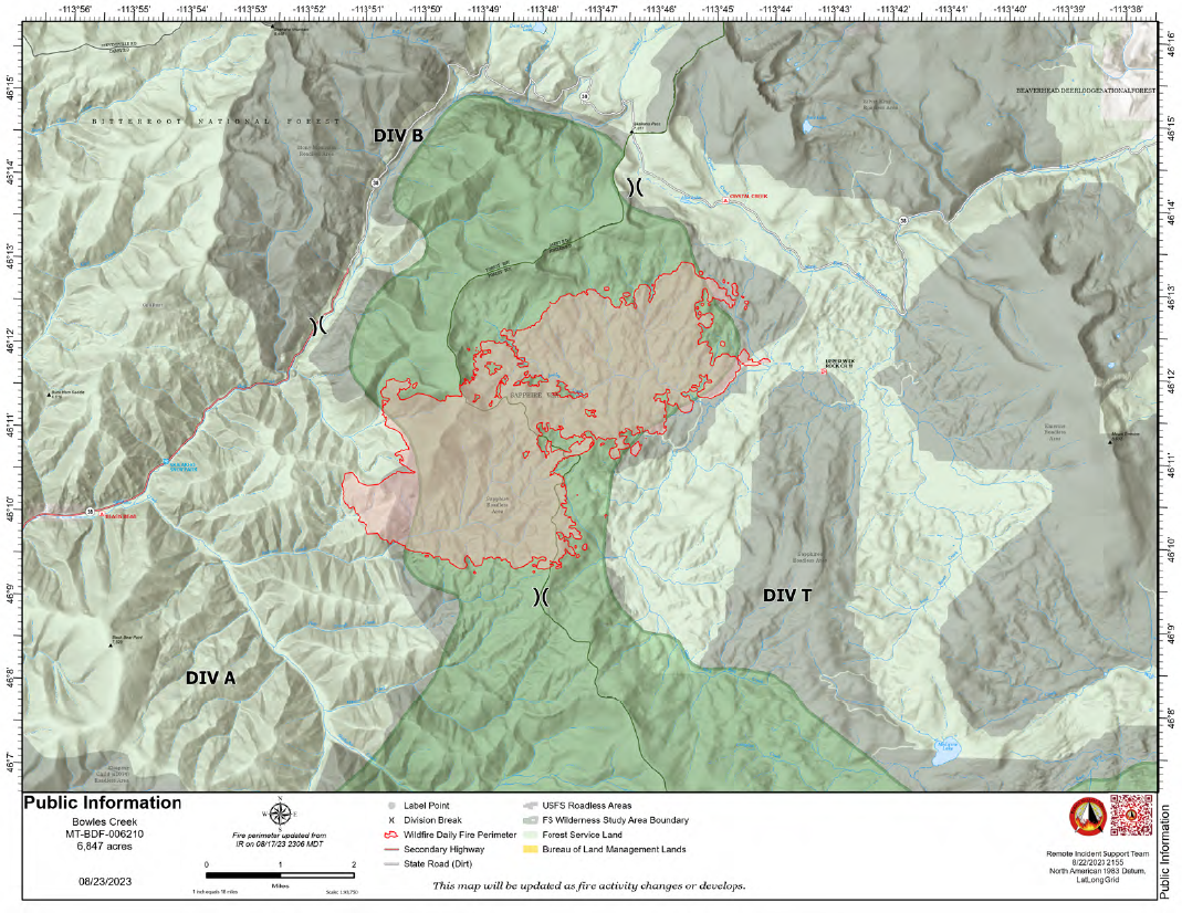
Bowles Creek Fire Update August 23 2023
Related Incident: Bowles Creek Fire
Publication Type: News
The Nevada Team 3 Incident Management Team is managing the Bowles Creek Fire.
The Bowles Creek Fire is currently at 6,847 acres. The fire completion has increased to 23%. Fire crews along Hwy 38 continue to work in the area. Motorists are urged to drive slowly and with caution. The public should also be aware the area will see a drying trend over the next several days, which may increase fire activity and smoke along the roadways.
The fire completion has increased to 23% as the objectives of confinement and point zone protection continue. Percent completion of objectives more accurately captures and reports the specific amount of work accomplished on the ground to manage fire spread and reduce the negative impacts to communities, infrastructure, and other identified values.
Suppression strategies being used include point protection and confinement due to values at risk and safety concerns. Fire crews continue to construct and strengthen fuel breaks along roads and other values at risk. Fire behavior is continuously being monitored by fire managers. Firefighters are utilizing firing operations and fuels reduction work to strengthen lines. Crews are also scouting and looking for further opportunities to strengthen lines.
23 de agosto 2023 Informacin al da para el Incendio Flat
Related Incident: Flat Fire
Publication Type: News
Extensión: 34,242 acres
Fecha de Inicio 15-julio-2023
Origen: 2 millas Suroeste de Agness, OR=
Contenido: 58%
Personal: 443
Recursos: 10 escuadrillas de bomberos l 4 helicópteros l 16 camiones de bomberos l 3 buldóceres l 17 cisternas l 4 máquinas masticadoras
Aspectos destacados: Las condiciones calurosas y secas contribuyeron a la baja propagación del fuego en las islas interiores de combustibles no quemados. Se observó un pequeño número de árboles ardiendo, pero no amenazaron las líneas de fuego. Dependiendo de la dirección del viento, el humo puede tener un impacto limitado en los esfuerzos de lucha contra incendios y las comunidades locales. Todos los recursos de extinción de incendios siguen comprometidos, patrullando las líneas de contención y vigilando los focos de calor aislados en el borde y en el interior. La atención a la alineación del viento / pendiente en los drenajes y los vientos de la cresta de la NW que podrían acelerar la propagación del fuego es un foco primario. Las cuadrillas están patrullando y limpiando la línea de contención. Los recursos de extinción de incendios están mejorando activamente todas las líneas de contingencia en el extremo sur del incendio con diversos equipos pesados, incluyendo motores, bulldozers, masticadores y plataformas de tala. Varias cuadrillas han sido enviadas al Bosque Nacional de Six Rivers para ayudar en el complejo de incendios Smith River en la frontera entre Oregón y California.
Actividades de hoy: Los objetivos para el Incendio Flat siguen siendo los mismos, siendo la supresión total el estado final deseado. Los bomberos siguen trabajando hacia la contención total del incendio. Continúan las evaluaciones visuales del perímetro del incendio con recursos terrestres y/o aéreos. Se está trabajando en el interior principalmente con helicópteros y algunas máquinas en función de las condiciones de acceso y peligro. La línea de contingencia en el sur se ha completado y la mejora de la línea continua. Los medios aéreos siguen vigilando el incendio y permanecen disponibles para apoyar los esfuerzos de ataque inicial y otros incendios si es necesario.
Tiempo: El tiempo: Las temperaturas son más cálidas y secas que la media hoy. Se espera que una tendencia al enfriamiento y una mayor humedad relativa lleguen el viernes y frenen de nuevo el comportamiento activo de los incendios. La tendencia al enfriamiento continuará durante la próxima semana. Estas condiciones deben ayudar a los esfuerzos de lucha contra incendios. Hay un 20% de probabilidad de chubascos aislados o tormentas eléctricas.
Humo: El humo puede ser visible desde las zonas circundantes. El pronóstico de humo está disponible en: Current Smoke Outlook for SW Oregon/NW California (wildlandfiresmoke.net)
Cierres: U.S. Highway 199 se ha cerrado al norte de Gasquet debido a los incendios en el Six River National Forest, por favor, utilice U.S. Route 101 a SR 42s para todos los viajes hacia y desde el Valle Rogue. El Servicio Forestal y las carreteras BLM no deben utilizarse como rutas alternativas debido a la actividad del fuego emergente. El Bosque Nacional Rogue River-Siskiyou (RRSNF) ha emitido una orden de cierre de la zona del incendio, incluyendo senderos, carreteras y una parte del río Illinois. Visite Rogue River-Siskiyou National Forest - Alerts & Notices (usda.gov) para más información.
Evacuaciones: Estado de evacuación de nivel 1 "Prepárense" para las zonas próximas al Flat Fire. Enlace a más información: Welcome to Curry County, OR
Restricciones: El peligro de incendio es actualmente extremo; la RRSNF está implementando Restricciones de Uso Público de Nivel 3. El RRSF, el BLM de Medford y el ODF han aplicado restricciones de uso público de nivel 3 en la sección salvaje del río Rogue. Para más información: https://tinyurl.com/ueuznr6e\
Flat Fire Morning Update 08232023
Related Incident: Flat Fire
Publication Type: News
Size: 34,242 acres
Start Date: July 15, 2023
Point of origin: 2 miles southeast of Agness, OR
Containment: 58%
Total personnel: 443
Resources: 10 crews l 4 helicopters l 16 engines l 3 bulldozers l 17 water tenders l 4 masticators
Highlights: Hot, dry conditions contributed to low rates of fire spread in interior islands of unburned fuels. A small number of torching trees were observed but did not threaten fire lines. Depending on wind direction, smoke may have some limited impact on firefighting efforts and local communities. All firefighting resources remain engaged, patrolling containment lines, and monitoring isolated heat sources on the edge and in the interior. Attention to wind/slope alignment in drainages and ridge-top winds from the NW that could accelerate fire spread is a primary focus. Crews are patrolling and mopping up containment line. Firefighting resources are actively improving all contingency lines at the southern end of the fire with various heavy equipment including engines, dozers, masticators and logging rigs. Several crews have been sent to the Six Rivers National Forest to assist with the Smith River Complex at the Oregon/California border.
Today’s Activities: The objectives for the Flat Fire remain the same with full suppression being the desired end state. Firefighters continue working towards full containment of the fire. Visual assessments of the fire perimeter with ground and/or aviation resources continue. Work is progressing in the interior primarily with helicopters and some engine work depending on access and hazard conditions. Contingency line in the south is complete and line improvement continues. Air resources continue to monitor the fire and remain available to support initial attack efforts and other fires if required.
Weather: Temperatures are warmer and drier than average today. A cooling trend and higher relative humidity is expected to arrive Friday and again slow active fire behavior. The cooling trend will continue into the next week. These conditions should help firefighting efforts. There is a 20% probability of isolated showers or thunderstorms.
Smoke: Smoke may be visible from the surrounding areas. The Smoke Outlook is available at: Current Smoke Outlooks (wildlandfiresmoke.net)
Closures: U.S. Highway 199 has been closed north of Gasquet due to fires on the Six River National Forest, please use U.S. Route 101 to SR 42s for all travel to and from the Rogue Valley. Forest Service and BLM roads should not be used as alternate routes due to emerging fire activity. The Rogue River-Siskiyou National Forest (RRSNF) has issued a closure order for the fire area including trails, roads, and a portion of the Illinois River. Visit https://bit.ly/RRSNFAlerts for more information.
Evacuations: Level 1 “Get Ready” evacuation status in place for areas in the vicinity of the Flat Fire. Link to more information: https://tinyurl.com/currycountyem
Restrictions: Fire danger is currently extreme; the RRSNF is implementing Level 3 Public Use Restrictions. Level 3 PURs on the Wild Section of the Rogue River have been implemented by the RRSF, Medford BLM and ODF. More information: https://tinyurl.com/ueuznr6e\
East Fork Fire August 23 2023 UPDATE
Related Incident: East Fork Fire
Publication Type: News
East Fork Fire - August 23, 2023
NORTHERN ROCKIES TEAM 6
INCIDENT COMMANDER: Paul Roose
Kootenai National Forest/Flathead National Forest
Fire Information 406-285-8634 Eastforkfireinfo@gmail.com
https://inciweb.nwcg.gov/incident-information//mtknf-east-fork-fire
August 23, 2023
Location: 12 miles south of Trego, MT
Start Date: 7/30/2023 Cause: Lightning Size: 4,614 acres* Containment: 5%
Total Personnel: 530 Engines: 16 Hand Crews: 11
Yesterday’s Events: The East Fork Fire received approximately 0.6” of rain over the last two days. Hand crews focused on areas of opportunity, including moving in as close as possible to the fire’s edge and tackling spot fires to the north of the main fire. Additional heavy equipment arrived, which will build the team’s capacity for activities such as fireline construction and road clearing. The incident management conducted a public meeting last night at the Olney-Bissell School. If you were unable to attend, you can check the Kootenai and/or Flathead National Forests’ Facebook page in the near future for a video of this meeting.
Plans for Today: The reduced fire intensity allows firefighters to more rapidly extend the existing fireline. Firefighters will continue to work to extinguish all spot fires and use drones for reconnaissance, especially in the Martin Creek area. Today’s weather should permit aviation resources such as helicopters and scoopers to join in the effort as well. Night operations will also continue, including patrols and the removal of logs from the fire area.
Evacuations: Some communities remain in a Pre-Evacuation Warning. Residents may return to their homes under a Pre-Evacuation Warning, but may need to leave again on short notice. For more information, go to the Sheriff’s Department website.
Public Meetings: No public meetings are scheduled at this time, but fire personnel will be available to answer questions at the farmer’s market in Eureka this afternoon.
*Updated acreage information was not available. Heavy smoke has prevented an IR flight for the past few days.
August 23 2023 Colt Fire Fact Sheet Update
Related Incident:
Publication Type: News
Current
The break in rain allowed crews to continue patrols and monitoring for pockets of heat.
Suppression repair and rehabilitation plans are being implemented in areas of containment.
Forest Service closures are still in effect around the fire area. For your safety and the safety of fire
crews, please do not violate closure orders. Know before you go.
Outlook
The forecast is calling for rain showers Wednesday morning, followed by warming and drying in
the coming days.
Firefighters will engage in mop up activities, as weather allows.
In areas of containment, suppression equipment will continue to be staged and removed
from the fire line.
Closures
The Lolo National Forest has lifted the closure of the following:
Rainy Lake Campground and access road
Alva Lake Campground and access road
All other Forest closures remain in place, including Lakeside Campground
Specific closure information can be found at
https://inciweb.wildfire.gov/incident‐information/mtmts‐colt‐fire.
Black Feather Fire Daily Update August 23 2023
Related Incident: Black Feather Fire
Publication Type: News
Update: August 23, 2023, Suppression tactics continue on the Black Feather Fire
Acres: 2,198 acres
Start Date: August 5, 2023
Cause: Lightning
Fuels: Timber, Brush, Understory
Containment: 28%
Resources: 127 personnel
Location: Approximately 9 miles south of Gallina, NM, on the Santa Fe National Forest, Coyote Ranger District. Near the Peñas Negras Trail in the San Pedro Parks Wilderness.
Highlights: Resources continue to work the southern lines and continue along the wilderness boundary. Progressing and securing the fires edge. Crews are utilizing UAS (unmanned aircraft system) with infrared capabilities to scout for more hot spots to continue suppression tactics. Suppression repairs are continuing, with heavy equipment rehabilitating roads and fireline rehabilitation.
Hand crews reached more into the wilderness to continue scouting and securing the fire edge. Crews outside of the wilderness were patrolling and monitoring the fires edge along with securing any hotspots or smoke showing within the fires perimeter.
Operations: Suppression efforts are continuing within the wilderness and along the southern edge of the fire. Crews utilized an infrared drone to help identify areas with greater fire activity and focus their efforts on those locations. With heavy dead and down logs and fire weaken trees in the wilderness, fire managers are carefully monitoring suppression activities in relation to weather and fire behavior to ensure incident objectives are met while remaining focused on firefighter safety.
Safety: Equipment and fire crews are actively moving in and around the fire area, including roads reopening today. Please use caution when traveling around the Black Feather Fire. The Temporary Flight Restriction is still in place. Please do not fly drones anywhere near the fire. If you fly, we can’t fly.
Weather: Overnight weather will improve as temperatures cool and relative humidity will rise. Gusty winds will persist out of the southeast. The remainder of this week will see improving moistures each day with the chances of showers and thunderstorms, especially towards the end of the week.
Restrictions/Closures: Effective Monday, August 21, the Santa Fe National Forest has issued an updated area, road, and trail closure in part of the Coyote Ranger District. See https://bit.ly/BlackFeatherClosureUpdate for information and a corresponding map. Forest Road 103 is now open. Closures will be adjusted based on fire activity.
Smoke: Variations in temperatures, humidity & fire activity will impact smoke conditions in the coming days and weeks. Smoke may be more and less visible in the area as active smoldering takes place. Smoke-sensitive individuals and people with respiratory problems or heart disease are encouraged to take precautionary measures. Air quality information is available at https://www.airnow.gov/.
Evacuations: The communities of Mesa Pinabetal, Mesa Poleo, and Wetherill remain in ‘Ready’ status. The Coyote Senior Center is open to evacuees, and livestock can be taken to the Rio Arriba Rural Event Center near Abiquiu. The Rio Arriba County Sheriff’s Office will coordinate evacuations if they go into effect. For more information, use the QR code below and visit the Sheriff’s Office Facebook page: https://www.facebook.com/profile.php?id=100079688263048.
Fire Information: 505-460-0499 – 2023.blackfeather@firenet.gov
InciWeb: https://inciweb.nwcg.gov/incident-information/nmsnf-black-feather-fire
Facebook: https://www.facebook.com/blackfeatherfireinfo
New Mexico Fire Information: https://nmfireinfo.com/
Deep Fire Update August 23 2023
Related Incident: Deep Fire
Publication Type: News
CURRENT SITUATION
A community meeting will be held TONIGHT, August 23, 2023, at the IOOF Hall in Trinity Center, Ca at 7:00 p.m.
The Deep Fire showed little overall growth and is still mapped at 3,823 acres. Containment remains at 16%. As anticipated, fire behavior did pick up yesterday as vegetation began to dry out. The fire continues to smolder in lighter ground fuels and individual snags continue to burn.
Yesterday, crews looked for opportunities to work as closely to the fire’s southern edge as possible. They’ll start building line today from Cherry Flat along the ridge north/northeast to the Wilderness boundary, with the intent of keeping the fire as much as possible in the Wilderness. Protecting the Trinity Alps Resort, the Van Matre and other private inholdings, timberlands, and other infrastructure remains the top priority. Sprinklers and hose have been placed and engines remain available to respond should fire approach.
On the east side of the fire, the terrain remains challenging as burning material from upslope continues to roll across the trail and ignite vegetation between the Stuart Fork Trail and the creek. Crews remain on hand to extinguish any slopovers caused by rollout and to mop up carefully to ensure that the control line along the trail holds.
The steep, rocky north side of the fire is not conducive to direct tactics but crews are looking for opportunities to keep northern spread minimal. They also continue to deal with rollout and burning snags. On the east, little growth has been observed as the fire moves into large rock outcroppings and light high elevation fuels.
Critical resource needs, including for Wilderness-capable Advanced Life Support, Rapid Extraction Modules, and specialized crews for working in the steep and rugged terrain, continue to be met. Many firefighters are remaining on the fireline for 24 hours, and they are being resupplied by mule train and by helicopter when air is clear.
WEATHER
The weather today is expected to trend warmer and drier. Light diurnal winds are anticipated, with little to no threat for convective activity.
ROAD CLOSURES
There are currently no road closures associated with the Deep Fire. For information on roads in the area, visit https://dot.ca.gov/
FOREST CLOSURES
There is a forest closure associated with the Deep Fire. For current information on forest closures, visit https://www.fs.usda.gov/stnf
EVACUATION UPDATES
For the latest evacuation information from the Trinity County Sheriff’s Department: https://www.facebook.com/people/Trinity-County-Sheriffs-Office/100064589806351/
For information on evacuation resources from the Trinity County Office of Emergency Services: https://www.trinitycounty.org/OES
To sign up for codeRED notifications: text “TrinityCA” to 99411.
River Road East Fire Public Meeting Thursday August 24 Plains MT
Related Incident:
Publication Type: Announcement
River Road East Fire Public Meeting
Thursday, August 24, 2023
6:00 to 7:00 pm
Plains High School Gym
412 Rittenour Street
Plains, Montana
Fire personnel, agency representatives, and local officials will be present to provide updates and be available for questions.
The meeting will be held in-person and will be livestreamed on the River Road East Fire Facebook page, if internet strength allows. We will record the meeting and post it later.