
Happy Camp Incident Update August 23 2023 800 pm
Related Incident: 2023 Happy Camp Complex Klamath NF
Publication Type: News
Community Meeting: A community meeting will be held in Fort Jones on Thursday, August 24, at 5:30 p.m. The meeting will be at the Quartz Valley Indian Reservation, 9040 Sniktaw Lane. The meeting will be live-streamed on social media. More details will be available on Thursday.
Fuels on the Happy Camp Complex have started to dry, and fire behavior is picking up, primarily on the west side of the complex. Today, the Canyon, Three Creeks, and Elliot fires burned together and will now be known as the Elliot Fire. The Swillup, Ufish, and Malone fires remained active through the afternoon. The Malone fire continues to grow due to burning fuels rolling downhill from Titus Ridge and igniting vegetation below. It does have indirect dozer line around it.
Firefighters are going direct on the fire’s edge when possible but have been hampered by steep terrain and the potential of fire igniting below and burning back up toward them. Like the Malone, the Ufish fire is in terrain difficult to access. Crews have been unable to attack the Ufish directly at the fire’s edge. On the Elliott fire, crews continue to use existing forest roads, Dillion Creek and Hwy 96 to encompass the active fire area.
Minimal fire behavior has been observed on the Head fire, the largest fire in the complex. Hand crews and dozers are making steady progress on all flanks of the fire.
Direct and indirect fire lines are being constructed on the Gold and Scott fires. On the Lake fire, a hand line has been constructed on the north end, but fire crews are being challenged by difficult terrain on the south flank.
Work has gone well on the Den and Townsend fires, and staffing will be decreased tomorrow. Resources will be shifted to higher priorities in the complex.
WEATHER: Increased atmospheric instability will increase the chance of dry thunderstorms with strong outflow gusts on Thursday in the late afternoon and evening. The National Weather Service in Medford has declared a Red Flag Warning beginning Thursday at 5:00 p.m. and continuing through Friday at 8:00 a.m.
EVACUATIONS: View current Siskiyou County evacuation orders, warnings by visiting: community.zonehaven.com. Siskiyou County residents are encouraged to sign up for rapid emergency notifications using the CodeRED emergency alert system. https://www.co.siskiyou.ca.us/emergencyservices/page/codered-emergency-alert
An evacuation center has been established at the Kahtishraam Wellness Center, 1403 Kahtishraam, Yreka, CA 95097. Call (530) 340-3539 if you have questions regarding the shelter.
ROAD CLOSURES: Highway 96 is closed from Seiad Creek Road to two miles east of Horse Creek. Scott River Road is closed at Kelsey Creek Road. Fire and debris flow will continue to impact the Highway 96 corridor. Please check the Cal Trans website before traveling in the area, quickmap.dot.ca.gov. County Road closures will be listed on the Siskiyou County Public Works website, https://www.co.siskiyou.ca.us/publicworks/page/closures-and-delays. If you are traveling and encounter mud or debris flow across the roadway, do not attempt to cross over the flow. Vehicles can easily be swept off the roadway.
FOREST CLOSURE: Two closure orders have been implemented: Happy Camp Complex Emergency Fire Closure, No.05-05-23-06; Happy Camp Complex Emergency Fire Closure, No. 05-05-23-07. Please refer to https://www.fs.usda.gov/alerts/klamath/alerts-notices to view the orders and maps.
TEMPORARY FLIGHT RESTRICTION (TFR): A TFR has been established over the fire area. Flight restrictions include the use of drones. The operation of drones under the TFR is prohibited.
PACIFIC CREST TRAIL: The Pacific Crest Trail has been impacted by the Happy Camp Complex and a portion of the trail is within an Emergency Closure Order on the Klamath National Forest. The trail is closed between Etna Summit and the Oregon border.
AIR QUALITY: For information regarding smoke impacts and what you can do to protect yourself, visit: https://www.airnow.gov/
- Fire Information:
- Public Phone: (530) 330-5441
- Media Phone: (530) 330-5452
- Hours: 8:00 a.m. to 8:00 p.m. daily
- Email: 2023.happycampcomplex@firenet.gov
- Incident Website: inciweb.wildfire.gov
Six Rivers National Forest Closures
Related Incident: 2023 SRF Lightning Complex and Redwood Lightning Complex
Publication Type: Closures
Follow the link below for Forest Closures:
For a list of general closures on the Six Rivers National Forest visit: https://www.fs.usda.gov/detail/srnf/notices/?cid=FSEPRD1096395
Community Meeting in Fort Jones Thursday August 24 2023 530 pm
Related Incident: 2023 Happy Camp Complex Klamath NF
Publication Type: Announcement
Community Meeting
in Fort Jones
Thursday August 24 at 5:30 p.m.
Quartz Valley Indian Reservation
9040 Sniktaw Lane , Fort Jones CA 96032
Virtual and in-person.
YouTube: https://www.youtube.com/@ciimt5
Facebook: https://www.facebook.com/KlamathNF/
Klamath National Forest Fire Activity Update August 23 2023
Related Incident:
Publication Type: News
Klamath National Forest Fire Activity Update – August 23, 2023
Yreka, Calif., – Firefighters continue working multiple small fires across the Klamath National Forest not associated with the Happy Camp Complex. Since August 15th, local firefighters have responded to 23 additional fires ranging in size from approximately 0.1 to 15 acres.
Minimal fire behavior occurred across the Klamath National Forest yesterday. Rain and high humidity across much of the eastern portion of the forest contributed to poor burn conditions, allowing firefighters to make progress on many of the fires not included in the Happy Camp Complex. The west side of the forest received much less precipitation; however, higher humidity contributed to moderated fire behavior. Higher temperatures and clear skies will return today, setting the stage for potentially increased fire activity.
Fire officials have declared the following fires out. They will no longer be reported on: Clear Fire, Doe Fire, Dutch Fire, Henry Fire, Hog Fire, Intersection Fire, and Shadow Fire.
The forest continues to manage fires on all ranger districts:
Happy Camp/Oak Knoll District:
- The Berry Fire near Huckleberry Mountain is approximately 0.2 acres and has line around the perimeter. A reconnaissance flight will take place over this fire today.
- The Capitan Fire near Capitan Mountain is approximately 2 acres and has line around the perimeter.
- The Devils Fire near Seiad Low Gap is approximately 2.5 acres and is controlled.
- The Indy Fire along Independence Creek near the border of the Marble Mountain Wilderness. This fire resides in inaccessible terrain. Fire officials have been unable to locate the exact location due to weather and smoke. A reconnaissance flight will take place to locate this fire today.
- The Titus Fire in the Marble Mountain Wilderness south of Norcross Campground is approximately 15 acres. The fire received significant rain and is smoldering in difficult to reach terrain. A reconnaissance flight will take place over this fire today.
Salmon/Scott River Ranger District:
- The newly reported Uncle Fire near Uncles Lake in the Marble Mountain Wilderness is approximately 0.2 acres with crews enroute.
- The Boulder Fire near Indian Scotty Campground is approximately 0.1 acres and is contained.
- The Box Fire, near Box Camp Trailhead is approximately 0.5 acre and is contained.
- The Grizzly Fire in the Russian Wilderness is approximately 1.5 acres and contained.
- The Picayune Fire near Picayune Lake, east of Forks of Salmon is approximately 1 acre and is contained.
- The Titmouse Fire near Titmouse Gulch near Little North Fork Trailhead is approximately 0.5 acres and is contained.
- The Whiskey Fire near Whisky Camp and Spirit Lake in the Marble Mountain Wilderness is approximately 0.1 acres and is in patrol status.
Goosenest Ranger District:
- The Ball Fire near Ball Mountain is approximately 0.25 acres and is in patrol status.
Evacuation Orders and Warnings: Evacuation orders and warnings remain in effect. Monitor CodeRED and the Siskiyou County Sheriff Facebook Page for current information.
Forest Closures: The Klamath National Forest has issued an emergency closure order for two portions of the forest. The purpose of the closure is to provide for public safety in response to ongoing wildfire activity across the forest, including the Happy Camp Complex. The closure prohibits the public from entering portions of the forest in or near the vicinity of ongoing wildfire activity. The closure order also prohibits the use of roads, trails, and developed recreation sites within the closure.
- Happy Camp Ranger District Closure Location: The closure order extends from Happy Camp south to the Marble Mountain Wilderness boundary at Norcross Recreation Area. The closure continues west along the edge of the Marble Mountain Wilderness to the Siskiyou Wilderness boundary. From there, the closure runs north along the Siskiyou Wilderness, down Clear Creek to Highway 96, and then north back to Happy Camp near Curly Jack Campground.
- Oak Knoll and Scott River Ranger Districts Closure Area: The closure order is generally northwest of Scott Valley and includes some of the Marble Mountain Wilderness near Lover’s Camp. From the Wilderness boundary, the closure continues along Grider Creek north to Seiad Valley. The closure extends northeast of Seiad Valley to areas north of the Klamath River.
- A map of the closure order, including specific roads, trails, and recreation sites can be found on the Klamath National Forest Website:
- Happy Camp District Closure: https://www.fs.usda.gov/Internet/FSE_DOCUMENTS/fseprd1132183.pdf
- Oak Knoll and Scott River Districts Closure: https://www.fs.usda.gov/Internet/FSE_DOCUMENTS/fseprd1132187.pdf
The Pacific Crest Trail is closed from Etna Summit to the Oregon border.
Dillon Creek Campground is closed due to its proximity to the Elliot Creek Fire.
Highway 96 and the Scott River Road have hard closures.
Information on Klamath National Forest fires that are not part of the Happy Camp Complex can be found at: https://inciweb.nwcg.gov/incident-information/caknf-2023-klamath-national-forest-august-lightning-fires
Information on the Happy Camp Complex can be found at: https://inciweb.nwcg.gov/incident-information//caknf-2023-happy-camp-complex-klamath-nf
Fire Restrictions:
Fire restrictions are in place on the Klamath National Forest. Campfires are only permitted in developed campgrounds and designated wilderness areas. Area closures are in place for the Happy Camp Complex, effective today. Full descriptions of restrictions and closures are available at: https://www.fs.usda.gov/alerts/klamath/alerts-notices
*Please obey any evacuation Orders and Warnings that have been issued*
# # #
Sanders County Sheriff Opens McLaughlin Creek Road to RESIDENTS August 23
Related Incident:
Publication Type: Announcement
Sanders County Sheriff's Office Announcement, Wednesday, August 23, 12 pm
ATTENTION MCLAUGHLIN CREEK RESIDENTS!!!!!
This road will be opening as of 2pm today (08/23/2023 for RESIDENTS/PROPERTY OWNERS ONLY!
You must stop at check point with the Deputy and get a resident card. This must be kept on your dash of your vehicle. Visible to Deputies and fire personnel.
Firefighters will still be working in the area and will have equipment and vehicles up there. They have the RIGHT OF WAY.
Please limit your travel on this road and make one worth while trip to town versus making several in a day, if possible.
Please be aware of falling rock, trees and debris on your own property and on the roadway. Things will still be shifting and settling for a while. Weather events will increase the risk.
Know if you enter the area you are doing so at your own risk. This is in an effort to get everyone back up to your properties.
Thank you to each and everyone of you for your patience. Please be safe and help keep the Firefighters safe up there as well.
West Mountain Fire August 23 2023 Update
Related Incident:
Publication Type: News
Start Date / Time: August 3, 2023
Cause: Lightning
Size: 603
Containment: 0%
Location: Northeast of Capitan, located on West Mountain in the Capitan Mountain Range.
Fire Strategy: Confine and Contain
Resources: 1 Handcrew, 1 Wildland Fire Module (WFM), 3 engines, 2 dozers, 2 masticators, 1 water tender. Total personnel:90
Fire behavior: Low/Moderate fire behavior.
Types of vegetation in the area (aka fuels): Pinyon pine, juniper, mixed conifer
Values at risk: No structures or communities are at immediate risk.
Update: 90 firefighters and other support personnel will continue with their confine-and-contain strategy on the West Mountain Fire, a lightning-caused wildfire northeast of Capitan.
The intended result of managing naturally-caused wildfires is to reduce hazardous fuels, encourage the growth of native plants, increase species diversity, and restore ecological balance. Ultimately, this can help reduce the potential for future high-severity wildfires.
Today, rain occurred over the fire area, affecting operations. Ongoing operations are dependent on the changing weather systems. Crews remain on-scene to ensure hotspots are monitored and the wildfire remains within the intended parameters. Conditions are continually evaluated for firefighter safety and operational effectiveness.
Smoke: Smoke will be visible in coming days as the fire continues to progress across the landscape. Smoke will be heavier in the mornings as it settles into lower elevation and will lift as temperatures increase. Smoke will be visible along HWY 246, and from the communities of Capitan and Ruidoso.
Visitor Information: Visitors are advised to stay out of the fire area to allow for firefighters to quickly and safely access the fire. Hunters and recreators are advised to use precautions in the area. Expect to see smoke and related activity along HWY 246 outside of Capitan.
Evacuations: None
Road Closures: None
Major Injuries/Fatalities: None
More Information:
Facebook: https://www.facebook.com/westmountainfire2023 Twitter: @LincolnUSForest
Inciweb: https://inciweb.wildfire.gov/incident-information/nmlnf-west-mountain Other: www.NMFireInfo.com
Updates will be released daily to inform the public.
River Road East Fire Daily Update Wednesday August 23
Related Incident:
Publication Type: News
River Road East Fire
Fact Sheet
NORTHERN ROCKIES TEAM 1
INCIDENT COMMANDER: BRENT OLSON
Phone: 406-345-5972
https://inciweb.nwcg.gov/incident-information/mtlnf-river-road-east-fire
Email: 2023.RiverRoadEast@firenet.gov
Facebook: https://www.facebook.com/riverroadeastfire
Wednesday, August 23, 2023 at 10:00 am
Location: 6 miles east of Plains, Montana
Start Date: 8/18/2023
Cause: Unknown
Size: 16,772 acres
Containment: 2%
Total Personnel: 582
Crews: 12
Engines: 39
Helicopters: 6
KEY MESSAGE: Tree-felling crews and heavy equipment are working to remove hazardous burned trees and downfall along a portion of River Road East affected by the fire. Two days of rainfall within burned areas has weakened roots and loosened rocks, sending some debris onto the roadway. Crews are removing debris and hazards from the roadway to allow safer travel.
CURRENT STATUS: As intermittent rainfall subdued fire behavior yesterday, firefighting resources seized the opportunity to work on direct control lines along the fire’s north side (Henry’s Creek). Additional containment was gained yesterday (2%), and the fire size was updated from 16,790 acres to 16,772 acres to reflect an increase in mapping accuracy. A requested overnight infrared flight to locate areas of heat was not able to be flown due to cloud cover. Fire personnel reported that fire growth was minimal, and the most active area of fire was observed in Kennedy Creek in burned stumps and down logs. Crews worked to fall hazardous burned trees along access roads into the fire area. In remote areas, crews worked to find safe access points through steep, broken terrain in order to locate control line options. On the north side of the fire, crews extinguished areas of heat along the fire perimeter. The Structure Protection Group continued to work on assessments in order to build a structure protection plan.
PLANNED ACTIONS: Firefighters are working with residents to leverage local knowledge to locate the best option to construct a fire control line on the northwest flank of the fire. This proposed line would connect to the bluffs along River Road East and keep the fire spreading north of Pat’s Knob Road. Additional helicopters are arriving on scene today. These aircraft will be available to work with ground crews to deliver water to areas of heat to limit growth and reduce flame length, allowing ground personnel the opportunity to safely construct direct control lines along the fire’s active edge. If soil conditions allow, crews will continue to work from roads along the east side (Camas Prairie) of the fire to cut off fire spread to the east. A Public meeting is scheduled for tomorrow, Thursday, August 24th from 6-7 pm at the Plains High School Gymnasium where local officials and fire personnel will provide updates on the fire. The meeting will be live streamed on Facebook if the internet strength allows.
WEATHER: Today will begin a drying trend as the rain showers conclude. The area will return to more typical August weather with humidity levels plummeting from yesterday’s 50% to below 20%. The wind will be from the west/southwest at 10-20 mph throughout the day. Temperatures will range from 65-75 degrees in the valley and 58-68 degrees on the ridges.
EVACUATIONS: For Evacuation updates please visit the Sanders County Sheriff's Office Facebook Page at https://www.facebook.com/profile.php?id=100064593409765. The Montana Red Cross has a shelter open at the Church on the Move, 300 Clayton St., in Plains, MT.
FIRE SUMMARY AUGUST 23 2023
Related Incident:
Publication Type: News
The Salmon-Challis National Forest has detected four (4) new fires since the last summary.
Mule Fire (August 23): The fire is estimated at 0.10 acres. The fire, burning in dead/down fuels, is located approximately one (1) mile southwest of Indian Creek airstrip on the Middle Fork Ranger District in the Frank Church River of No Return Wilderness in the 2000 Little Pistol Fire. Two (2) firefighters and one helicopter are on scene working to suppress the fire.
Spring Fire (August 19): The fire was located approximately 2.5 miles southwest of Long Tom Lookout on the North Fork Ranger District. The 0.10 acre fire, burning in a single tree, was called out on August 20.
Crane Fire (August 17): The fire is estimated at approximately one (1) acre. The fire is located southeast of Bernard Mountain on the edge of the Middle Fork Ranger District in the Frank Church River of No Return Wilderness in 2010 Little Beaver Complex Fire. The fire is burning in subalpine fir & heavy dead/down fuels. The fire is creeping and smoldering. Firefighter and public safety are the number one priority on the Crane Fire. Due to the remote location of the fire, the steep and inaccessible terrain, and a heavy snag component in the fire area along with the predicted weather, fire managers will be monitoring the fire by reconnaissance flights and ground resources from strategic points outside of the wilderness. Weather permitting, the Forest will have additional information in the coming days.
Bear Fire (August 16): The fire was located approximately one (1) mile southwest of Bear Mountain on the Challis/Yankee Fork Ranger District. The 0.25 acre fire, burning in lodgepole pine, was called out on August 17.
Chilcoot Fire (August 11): The fire is estimated at approximately 685 acres burning in spruce and fir. The fire is located approximately two (2) miles northeast of Pistol Lake between Browning and Little Pistol Creeks on the western edge of the Middle Fork Ranger District in the Frank Church River of No Return Wilderness. The Chilcoot Fire is surrounded by previous fires including the Cascade Complex (2007), Kiwah (2018), Pistol (2018), and Buck Fires (2020). Firefighter and public safety is the number one priority for the Chilcoot Fire. When the fire was initially sized up, fire managers initiated actions to suppress the fire. Due to the remote location of the fire, the steep and inaccessible terrain along with lack of safe ingress and egress for firefighters, fire managers changed strategy, keeping firefighter safety in mind. Fire managers will be monitoring the fire by remote camera and reconnaissance flights. Values at risk in the area have been identified and trigger points have been established. If a trigger point is reached, additional actions will be taken by firefighters in order to protect those values at risk. Weather permitting, the Forest will have additional information in the coming days. The Chilcoot Fire can be found on InciWeb at https://inciweb.nwcg.gov/incident-information/idscf-chilcoot-fire.
Wilson Fire (August 9): The 0.10 acre fire is located approximately six miles northwest of Middle Fork Peak Lookout on the North Fork Ranger District in the Frank Church River of No Return Wilderness. The fire is burning in grass and mountain mahogany in the 2000 Aperejo Fire. The fire is burning in an area with cliffs and is located in steep and rocky terrain. Middle Fork Peak Lookout and aerial resources will continue to monitor the Wilson Fire.
Hayden Fire (July 19): located approximately 18 miles west of Leadore on the Leadore Ranger District. The fire received substantial precipitation over the last several days and is being updated at https://inciweb.nwcg.gov/incident-information/idscf-hayden-fire.
To date, there have been 17 wildfires detected on the Salmon-Challis National Forest. 12 of these fires have been declared out.
Weather: Today and Thursday will be dry and warmer with only some isolated storms early this afternoon. Will see more shower and thunderstorm activity Friday as some more monsoonal moisture returns on southerly flow with at least a 20 percent chance of wetting rains. Isolated showers and thunderstorms will continue through the weekend.
Ensure your campfire is dead out. If it is too hot to touch, it is too hot to leave! One Less Spark Means One Less Wildfire.
Nationally, there are 56 uncontained large fires being managed under a full suppression strategy and 49 large fires managed under a strategy other than full suppression.
Visit our website at: www.fs.usda.gov/scnf/, ‘Like Us’ on Facebook @salmonchallisnf, and ‘Follow Us’ on Twitter @salmonchallisnf.
August 23 2023 Daily Update
Related Incident:
Publication Type: News
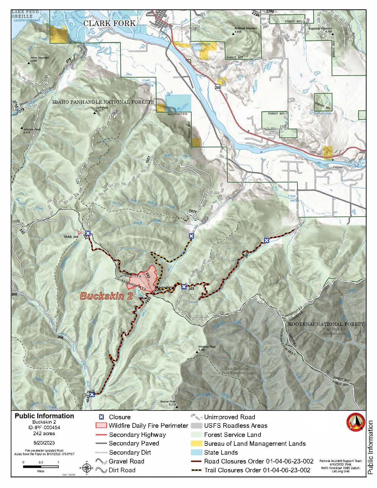
Buckskin 2 Fire - August 23, 2023
Idaho Panhandle National Forests, Sandpoint Ranger District
Fire Information: 208-557-8813
https://inciweb.nwcg.gov/incident-information/idipf-buckskin-2-fire
Type 3 Incident Commander, Brian Hicks
Location: Located approximately 8 miles due south of Clark Fork, ID on the upper end of Twin Creek and Buckskin Saddle, south of Highway 200
Start Date: 8/4/2023 Cause: Undetermined Size: 242 acres Containment: 75%
Total Personnel: 68 Engines: 1 Hand Crews: 2 Modules: 2
Heavy Equipment: 1 Water Tender
A weather system in the area yesterday dropped almost half an inch of rain in some areas. There continues to be no growth on the fire in several days, and the fire behavior is just a smoldering interior allowing crews and equipment to improve the direct line along the west flank of the fire. Engine crews will continue supporting resources with water for mop up operations, while hand crews will continue to mop up and secure the fire’s edge. The fire remains 1.8 miles from the nearest structure. The Forest Closure remains in place for fire firefighters and public safety around active operations.
Until a season-ending event occurs, smoke may be visible from pockets of unburned fuels within the perimeter of the fire. The smoke that has settled into the area is from existing and new large fires in Washington and British Columbia. See https://fire.airnow.gov/ for more detailed smoke information.
The published email and phone number will still be monitored. If you are having any issues connecting to these sites, or simply have questions about the status of the fire, please call the fire information line at 208-557-8813. The line is staffed from 7 AM to 7 PM, and all calls will be returned.
EVACUATION STATUS
The Bonner County Sheriff’s Office has rescinded the READY notification for the Twin Creek Rd and Rearden Rd residents in Clark Fork as of August 19, 2023, at 4 PM. Citizens should continue to stay alert and prepared, as fire conditions are always subject to quick and unexpected changes. Sign up for Bonner County Sheriff’s Office emergency messaging through NIXLE at www.nixle.com to receive local status updates.
CLOSURES AND SPECIAL MESSAGES
Forest Closure Order is in effect for roads associated with the Buckskin Fire; the intersection of Forest Service Roads 203 and 332, the intersection of FSR 1021 and 332, and 1533 and 306 in Clark Fork. UTV trail 77 is closed as well. An extension of the FSR 203 closure, extending to the edge of private land, took effect on 8/15 at 0700. The public is prohibited from the general area for firefighter safety and asked to practice caution while driving near firefighters and apparatuses.
Stage II Fire Restrictions are in effect. To view the Idaho Fire Restrictions Plan and a statewide map with current information regarding fire restrictions, please visit https://www.idl.idaho.gov/fire-management/fire-restrictions-finder.
The Temporary Flight Restriction that was in place for the safety of our aerial resources and firefighters on the ground has been officially rescinded as of August 20, 2023. Drone operators are reminded to never fly around active fire operations, as it could create critical interference with firefighting efforts. If you fly, we can't!
WEATHER
Showers are likely, and possibly a thunderstorm. Widespread haze before 4 p.m. Mostly cloudy, with a steady temperature around 64. Northwest wind around 8 mph. The chance of precipitation is 70%. New rainfall amounts of less than a tenth of an inch, except higher amounts possible in thunderstorms.