
South Fork Daily Update for August 24 2023
Related Incident: South Fork Complex
Publication Type: News
Current Situation: 3-9 Fire: 1,430 acres with 0% containment Pilot Fire: 913 acres with 26% containment and air support Pellitreau Fire: 3 acres with 100% containment Sulphur Fire: 31 acres with 95% containment 20% overall containment for the Complex
People and Equipment: 583 personnel, crews, engines, dozers, water tenders
A Red Flag Warning is in place today from 3 pm to Friday morning at 2 am for potential scattered thunderstorms in Del Norte, North and East Humboldt, Western Siskiyou and Western Trinity Counties. This may result in scattered thunderstorms producing abundant lightning, outflow wind gusts up to 40 mph and a potential for increased fire spread in our fire area.
3-9 Fire Firefighters will be brushing and strengthening the road system along Pilot Creek and on the southwestern area of the 3-9 fire area to improve the road system coming up to the Dan East Trail. Yesterday, firefighters were able to secure the handline on a 30-acre slop-over from Sunday night on the east side. Dozer and handlines have been improved up to the fire’s edge. Firefighters were successful in constructing handline along Bear Creek. Dozers and excavators are working to build containment lines to hold the southeastern perimeter. Helicopters are assisting the operation utilizing retardant drops. A mobile retardant base has been established in Hyampom.
Pilot Fire crews have successfully finished constructing handline along the road on the northeastern flank. The contingency lines along the eastern flank have been completed. Crews have been successful with the handline around Grouse Creek, on the eastern portion of the fire line. Operational plans for today continue to be secure and mop up the perimeter of the Pilot Fire and finish the contingency lines.
The Pellitreau fire is 100% contained and the Sulfur fire has 95% containment. Crews will continue to mop up the area and monitor and patrol to ensure fire remains within the containment lines. Most equipment has been pulled from these fires to assist the Pilot and 3-9 Fires.
Evacuation Warning: These remain in effect. Please continue to check the Trinity County Wildfire and Evacuation site for up-to-date status and locations: Trinity County Wildfire and Evacuation Map
Forest Closure: There are new Forest Closure orders for the South Fork Complex Fire that have been posted on the Shasta-Trinity National Forest website home page and on the Six Rivers National Forest (click on Forest Closures). Please avoid the closed areas.
River Road East Fire Daily Update Thursday August 24
Related Incident:
Publication Type: News
River Road East Fire
Fact Sheet
NORTHERN ROCKIES TEAM 1
INCIDENT COMMANDER: BRENT OLSON
Phone: 406-345-5972
https://inciweb.nwcg.gov/incident-information/mtlnf-river-road-east-fire
Email: 2023.RiverRoadEast@firenet.gov
Facebook: https://www.facebook.com/riverroadeastfire
Thursday, August 24, 2023 at 10:00 am
Location: 6 miles east of Plains, Montana
Start Date: 8/18/2023
Cause: Unknown
Size: 17,083 acres
Containment: 5%
Total Personnel: 675
Crews: 14
Engines: 45
Helicopters: 7
KEY MESSAGE: A public meeting will be held today, Thursday August 24 at 6pm in the Plains High School gym (412 Rittenour St.). The meeting will also be livestreamed to Facebook if the internet connection allows. Fire incident personnel will provide information about ongoing and planned firefighting operations and will be available to answer questions.
CURRENT STATUS: Fire containment has increased to 5% around the town of Paradise, MT on both sides of the Clark Fork River. Because of the progress firefighters have been making, the Sanders County Sheriff’s Office opened the McLaughlin Creek Road to residents only yesterday. The area is still under a pre-evacuation warning. Significant progress was made on the northwest flank of the fire yesterday as fire crews safely and successfully constructed handline through steep, broken terrain from the active fire edge above River Road East to the bluffs along the river. Heavy equipment continued to build line between Pat’s Knob Road and the fire perimeter, and the line now connects into the road system. Work will continue in this area as crews strengthen the line by removing vegetation that would carry fire. On the east side of the fire, heavy equipment and hotshot crews have been building control line, cutting the fingers off the fire to limit spread on the eastern side. The Structure Protection Group continued to work on assessments to build a durable, long term plan for structure protection. Several helicopters have been assigned to the fire to provide support. Included in this is a helicopter paramedic crew in place in support of the firefighting efforts, substantially reducing the potential medical response time.
PLANNED ACTIONS: As the weather returns to warmer and dry conditions, increased fire activity is likely. Smoke will be visible in more areas, and fire spread will increase as fuels continue to dry out from Monday’s rainstorm. Firefighters will continue to take advantage of the slower fire growth working to build containment line around much of the fire perimeter. Additional crews, engines, heavy equipment, helicopters and fire line leadership have arrived, allowing resources to cover more of the complex and remote terrain the fire is burning in. Helicopters will be working in support of ground crews delivering water to strategic areas to support perimeter control operations.
WEATHER: Today humidity levels will continue to be low, dropping below 30%. Temperatures will increase to approximately 10 degrees warmer than yesterday, 75-85 degrees in the valley and 68-78 ridges. Lighter westerly/southwesterly winds will be at 10 mph through the day.
EVACUATIONS: For Evacuation updates please visit the Sanders County Sheriff's Office Facebook Page at https://www.facebook.com/profile.php?id=100064593409765. The Montana Red Cross has a shelter open at the Church on the Move, 300 Clayton St., in Plains, MT.
August 24 2023 Colt Fire Fact Sheet Update
Related Incident:
Publication Type: News
Current
While work on the Colt Fire will continue, this will be the last Fact Sheet distributed.
Thursday will also be our last day posting to the Colt Fire Facebook page.
Suppression repair and rehabilitation plans are being implemented in areas of containment.
Forest Service closures are still in effect around the fire area. For your safety and the safety of fire
crews, please do not violate closure orders. Know before you go.
Outlook
Firefighters will continue to patrol, monitor, and mop up where hot spots are found.
In areas of containment, suppression equipment will be removed from the fire line.
Conditions on the ground will be assessed and reviewed by land managers to determine when
additional closure orders can be safely rescinded.
Closures
The Lolo National Forest has lifted the closure of the following:
Rainy Lake Campground and access road
Alva Lake Campground and access road
All other Forest closures remain in place, including Lakeside Campground
Specific closure information can be found at
https://inciweb.wildfire.gov/incident‐information/mtmts‐colt‐fire.
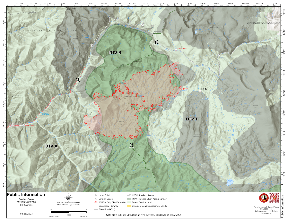
Bowles Creek Fire Update August 24 2023
Related Incident: Bowles Creek Fire
Publication Type: News
The Nevada Team 3 Incident Management Team is managing the Bowles Creek Fire.
The Bowles Creek Fire is currently at 6,985 acres. Fire crews remain present along Hwy 38. Construction crews will also be present on Hwy 38, as road grading is occurring today to mitigate for the increased traffic on the road. Additionally, due to recent rain and winds, several fallen snags have been removed from Hwy 38 over the last day. Motorists in the area should be aware of the potential for falling snags and increased personnel and equipment on the roadway.
Completion of fire management objectives remains at 23%. Fire personnel continue to work on confinement and point zone protection to protect values at risk. Fire crews continue to construct and strengthen fuel breaks along roads and other areas of value. Fire behavior is continuously being monitored by fire managers. Firefighters are utilizing firing operations and fuels reduction work to strengthen lines. Fire crews continue cold trailing along the southeastern portion of the fire. Cold trailing is a method of controlling a partly dead fire edge by carefully inspecting and feeling with the hand for heat to detect any fire, digging out every live spot, and trenching any live edge. This will ensure future firing operations in the area safely meet management objectives.
Bear Creek Daily Update August 24 2023
Related Incident: Bear Creek Fire
Publication Type: News
Bear Creek Fire start date:
August 1, 2023
Location: 23 miles Northwest of Pagosa Springs, Colorado
Cause: Lightning
Incident Commander:
Jay Kurth
Management Team:
NIMO Team 1
Management: Suppression
Fire size today: 415 acres
Containment: 0%
Completion: 71%
Personnel: 112
Evacuation Information:
Weminuche Valley is under pre-evacuation notice. Local residents should follow incident information and updates.
Closures:
-
Coleman Park in Pagosa Springs
INCIDENT OBJECTIVES:
-
Firefighter and Public safety are the highest priority.
-
Protect private lands within the Weminuche valley, natural resources, cultural and historic sites, recreation assets and critical infrastructure including powerlines and gas utility lines.
Indirect control lines are being utilized to accomplish multiple objectives of full suppression in accessible parts of the fire and confinement in areas that are remote and/or present high safety risks to firefighters. Overall, 71% of these objectives have been completed.
The Bear Creek Fire was inactive yesterday. The fire behavior trend remains the same with no growth in size beyond 415 acres. The National Incident Management Organization (NIMO) is transitioning with the incoming Type 3 team who will assume command at 6 am on Friday.
YESTERDAY’S ACCOMPLISHMENTS:
-
Firefighters remained alert for any changes in fire behavior.
-
Burned Area Emergency Response (BAER) team began reconnaissance of the fire.
-
Began transporting mastication equipment off the Mosca Road as completion of indirect lines was accomplished.
TODAY’S PLAN:
-
Continue structure protection with engine patrols.
-
Assess any changes in fire behavior.
-
Remove the Communications Command Repeater with help from Air Support.
WEATHER:
Increased cloud cover in the morning is likely. There is an 80% chance of wetting rain tomorrow afternoon and tomorrow night. Approximately 0.2 - 0.6 inches of precipitation is forecasted across the entire area.
![]() Incident Information: https://tinyurl.com/mrx4pp27
Incident Information: https://tinyurl.com/mrx4pp27
Facebook: https://tinyurl.com/mr2tpj69
Email : 2023.bearcreek@firenet.gov Information Line : 970-426-5370
Big Knife Update August 24 2023
Related Incident: Big Knife
Publication Type: News
After a season-slowing rain event earlier this week, fuels are beginning to dry, and wisps of smoke are visible in pockets around the fire. Crews completed the powerline assessment and continue to patrol and monitor fire activity in Agency Creek and along S-Canal Road. Anticipating the future warming and drying trends, the Jocko Lookout is being assessed for additional protection improvements. Crews are staging structure wrap, an aluminum/fiberglass covering that blocks up to 96% of radiant heat, at the tower in the event fire behavior picks up. Structure wrap works much in the same way as fire shelters do – deflecting radiant heat, absorbing convective heat, and protecting from airborne embers.
Jocko Lookout was built in 1969. These days, the treated-wood tower is only staffed in emergencies.
The Big Knife Fire is currently 1.25 miles north of the Rattlesnake Wilderness Boundary (Lolo National Forest) with no significant growth towards the Lolo National Forest in the last week. Smoke from the fire may impact the Snowbowl area, however the Lolo National Forest does not have any forest closures in place on the Missoula Ranger District.
CLOSURES AND SPECIAL MESSAGES: Several areas near the base of the mountains west of the Big Knife Fire remain in PRE-EVACUATION WARNING by order of the Lake County Sheriff. See the map for those locations in yellow (Jocko, Canal, Francis). The Tribal Primitive Area, Belmore Slough and Burnt Cabin Roads are closed.
A PRE-EVACUATION WARNING means you may remain in your home. Individuals in this status should not bring back evacuated livestock until this status is lifted.
A temporary flight restriction (TFR) is in effect around the fire area. Do not fly unmanned aircraft (drones) near the fire areas.
Weather: The four rain gauges deployed around the fire each measured more than an inch of rain. This morning’s temperatures dropped to the 40s, the lowest recorded so far on the fire. Today temperatures are anticipated to be the 70s today with relative humidity dropping into the 30% range.
FIRE RESTRICTIONS: Stage 1 fire restrictions are currently in place across the Flathead Indian Reservation and Lake County. Stage 1 fire restrictions remain in place in Granite County. In Stage 1 fire restrictions the following are prohibited until rescinded: Building, maintaining, attending, or using a fire or campfire except within a developed recreation site or improved site. Smoking, except within an enclosed vehicle or building, a developed recreation site or while stopped in an area at least three feet in diameter that is barren or cleared of all flammable materials. On the Flathead Reservation, operating a motorized vehicles off designated roads and trails. Visit https://www.mtfireinfo.org/ for more fire restriction information across Montana.
###
Quartz Ridge Daily Update August 24 2023
Related Incident: Quartz Ridge Fire
Publication Type: News
Fire start date: August 5, 2023
Cause: Lightning
Location: 13 miles Northeast of Pagosa Springs, Colorado
Incident Commander:
Jay Kurth
Management Team:
NIMO Team 1
Management: Suppression
Fire size today: 1,799 acres
Containment: 0%
Completion: 70%
Personnel: 160
Evacuation Information:
There are no current evacuations. Local residents should follow incident information for updates.
Closures:
-
Quartz Meadows Rd (NFSR#685)
-
Quartz Ridge Trail (NFST#570)
-
Quartz Creek Trail (NFST#571)
INCIDENT OBJECTIVES:
-
Firefighter and Public safety are the highest priority.
-
Protect private lands within East Fork San Juan River drainage, natural resources, cultural and historic sites, recreation assets, and critical infrastructure including powerlines and gas utility lines.
The Quartz Ridge Fire was relatively quiet throughout the day. “Bonfires” of burning and smoking dead, downed wood scattered across the fire continued. The pocket of fire within the rocky area on the east side of Quartz Creek is constrained by natural features and is not likely to grow during upcoming wetter weather.
The wildfire is burning in steep terrain in the South San Juan Wilderness. A combination of indirect and direct control lines is being utilized to accomplish multiple objectives of full suppression on accessible parts of the fire and confinement on parts that are remote and/or present high safety risks to firefighters. Overall, 70% of these objectives have been completed.
YESTERDAY’S ACCOMPLISHMENTS:
-
Continued to evaluate terrain and potential areas for containment outside of wilderness boundaries and scouted for strategic areas for control.
-
Assessed the burned area on the east side of Quartz Creek for control features and strategies.
-
Completed structure preparation along the East Fork Road at the McCormick Cabin.
-
Completed four of the seven miles of grading on the East Fork Road to improve access for fire personnel and the public.
TODAY’S PLAN:
-
Assess the burned area on the east side of Quartz Creek and the northern edge for control features and strategies.
-
Continue road grading operations along the East Fork Road.
-
Work with the incoming crews to orient them to the details of the fire.
WEATHER:
Increased cloud cover in the morning is likely. There is an 80% chance of wetting rain tomorrow afternoon and tomorrow night. Approximately 0.2 - 0.6 inches of precipitation is forecasted across the entire area.
![]() Incident Information : https://tinyurl.com/mr37bhnr
Incident Information : https://tinyurl.com/mr37bhnr
Facebook : https://tinyurl.com/y87cycm4
Email : 2023.quartzridge@firenet.gov Information Line : 970-426-5370
Deep Fire Update August 24 2023
Related Incident: Deep Fire
Publication Type: News
CURRENT SITUATION
The Deep Fire is currently 3,823 acres and is 51% contained.
Firefighters made good progress yesterday, and, aided by the weather, the Deep Fire did not grow in acreage, although there is still heat holding inside the fire perimeter. Aerial reconnaissance showed mostly smoldering with some small areas of is open flame and isolated burning snags. However, it also showed that the fire has run into rocks and lighter fuels, especially on the north and east edges. No heat is showing in those areas on infrared flights or through direct observation.
The west side of the fire continues to hold well. Crews are continuing to experience rollout of burning material from the steep slope down to the west side of the Stuart Fork Trail, and they are continuing to patrol for that and mop up any areas of heat they find remaining.
On the southern end of the fire, crews are looking for opportunities to contain the fire at its active edge. They are simultaneously building new lines parallel to the edge and opening and improving contingency lines to ensure they can stop the fire should it advance toward the south. Protecting structures and other private property in the area, including the Van Matre and other inholdings, the Trinity Alps Resort, and private timberlands remains the highest priority.
WEATHER
A Red Flag Warning for abundant lightning on dry vegetation has been issued for areas to our west, but NOT over the fire area. However, fire staff is remaining vigilant and preparing for strong outflow winds which could cause rapid fire growth, especially in areas with continuous heavy vegetation. Areas of particular concern are the northwest corner of the fire near Oak Flat, and the southern area, near Cherry Flat.
ROAD CLOSURES
There are currently no road closures associated with the Deep Fire. For information on roads in the area, visit https://dot.ca.gov/
FOREST CLOSURES
There is a forest closure associated with the Deep Fire. For current information on forest closures, visit https://www.fs.usda.gov/stnf
EVACUATION UPDATES
For the latest evacuation information from the Trinity County Sheriff’s Department: https://www.facebook.com/people/Trinity-County-Sheriffs-Office/100064589806351/
For information on evacuation resources from the Trinity County Office of Emergency Services: https://www.trinitycounty.org/OES
To sign up for codeRED notifications: text “TrinityCA” to 99411.
August 24 2023 Daily Update
Related Incident:
Publication Type: News
Yesterday the fire area saw a break in the rain showers that had remained over the area in recent days. Fire behavior stayed minimal, with areas of creeping and smoldering.
On Wednesday additional hand crews arrived and today they are expected to continue constructing fire line near forest road 417 to secure the fires western flank. Heavy equipment has made good progress removing hazardous trees along forest road 405 on the northern flank of the fire. Hand crews will be utilized on the northern flank of the fire today to start handline construction now that heavy equipment has cleared away hazard trees.
Aerial firefighting resources continue to be assigned to the East fire and are at the ready to provide water dropping missions shall the need arise. The infrared mapping mission that was planned for Wednesday was put on hold due to technical issues but is expected to be completed later today.
Weather: A high pressure system will linger over the area today and tomorrow brining higher temperatures and lower relative humidity. The drying trend will continue to decrease fuel moisture levels and fire activity has the potential to increase over the coming days. This weekend a weak stormfront is forecasted for the area but is not expected to produce much in terms of precipitation.
Closure Area: Remains in place for public safety and details including a map can be found on the East Fire InciWeb page and the Boise National Forest Facebook page.
Air Quality: http://idsmoke.blogspot.com/
Web: https://www.fs.usda.gov/boise/
Facebook: https://www.facebook.com/BoiseNationalForest
InciWeb: https://inciweb.nwcg.gov/incident-information/idbof-east.
East Fork Fire August 24 2023 Update
Related Incident: East Fork Fire
Publication Type: News
NORTHERN ROCKIES TEAM 6
INCIDENT COMMANDER: Paul Roose
East Fork Fire
Kootenai National Forest/Flathead National Forest
Fire Information 406-285-8634 Eastforkfireinfo@gmail.com
https://inciweb.nwcg.gov/incident-information//mtknf-east-fork-fire
August 24, 2023
Location: 12 miles south of Trego, MT
Start Date: 7/30/2023 Cause: Lightning Size: 4,614 acres* Containment: 5%
Total Personnel: 530 Engines: 16 Hand Crews: 11
Yesterday’s Events: Operations on Tuesday, August 23, focused on taking advantage of the weather and the pause in fire activity to put containment lines as close to the fire as possible given terrain and vegetation. In areas with better access, heavy equipment was able to widen roadways to serve as containment and contingency lines. Hand crews made good progress in more rugged areas. Trees weakened by the fire and rain are a primary concern as they can pose a safety risk. Sawyers took their time felling trees deemed to be hazards as part of the mop up efforts. Night operations continued to move logs and brush cut during the day shift. This will be an ongoing operation. An Unmanned Aircraft System (UAS), a drone, as well as helicopters were able to conduct reconnaissance flights to help firefighters identify priority areas and containment line possibilities.
Plans for Today: The recent rain has helped calm fire activity in the region and resources previously committed to other fires are coming available. A second 20-person hot shot crew arrives today and will begin constructing line adjacent to the fire. The hot shot crews will work in some of the most challenging terrain, such as the Martin Creek drainage. Additional hand crews should be on the way. Tree felling and mop of activities will continue, especially on the western side or “heel” of the fire. Crews will attempt back burning operations to help strengthen containment lines. Structure protection work has been completed and these resources will shift to help with the south side of the fire. While the rain saturated the fuels/soils in the plantations (new growth areas), significant rainfall did not reach the ground in old growth areas. Firefighters will be monitoring changing conditions and watching for increasing fire activity as the vegetation dries and the weather warms this week.
Evacuations: Some communities remain in a Pre-Evacuation Warning. Residents may return to their homes under a Pre-Evacuation Warning, but may need to leave again on short notice. For more information, go to the Sheriff’s Department website.
Public Meetings: No public meetings are scheduled at this time, but fire personnel will be available to answer questions at the farmer’s market in Trego this afternoon.
*Updated acreage information was not available. Heavy smoke has prevented an IR flight for the past few days.