
Big Knife Fire Update August 22 2023
Related Incident: Big Knife
Publication Type: News
Fire Behavior Analysts assigned to the Big Knife Fire utilized a weather analysis program that uses historical and current weather data to assess the fire outlook. Rain yesterday and forecast for today will be a fire season-slowing event, but it will not be fire season-ending event. A fire season-ending event consists of a combination of weather events followed by a persistent combination of environmental factors to mark the end of fire season. Weather events can include rain or snow, lower temperatures, higher relative humidity, and cloud cover. Environmental factors such as lower sun angles and shorter day lengths reduce the active fire burning period. By the middle of September, there is a 50% chance of a fire season-ending event happening. By the last week of October this chance increases to 90%. The weather is forecasted to get warmer and drier by Friday providing the opportunity for the fuels to dry out and support fire growth again. Fuel drying is expected to take longer than the rain event that wet the Big Knife Fire the first week of August. The crews on the fire will be patrolling and monitoring the fire perimeter today. Tonight will be the last night shift.
The Big Knife Fire is currently 1.25 miles north of the Rattlesnake Wilderness Boundary (Lolo National Forest) with no significant growth towards the Lolo National Forest in the last week. Smoke from the fire may impact the Snowbowl area, however the Lolo National Forest does not have any forest closures in place on the Missoula Ranger District.
CLOSURES AND SPECIAL MESSAGES: Several areas near the base of the mountains west of the Big Knife Fire remain in PRE-EVACUATION WARNING by order of the Lake County Sheriff. See the map for those locations in yellow (Jocko, Canal, Francis). The Tribal Primitive Area, Belmore Slough and Burnt Cabin Roads are closed.
A PRE-EVACUATION WARNING means you may remain in your home. Individuals in this status should not bring back evacuated livestock until this status is lifted.
A temporary flight restriction (TFR) is in effect around the fire area. Do not fly unmanned aircraft (drones) near the fire areas.
Weather: More rain is predicted tonight through Wednesday morning. Warming and drying starts on Thursday.
FIRE RESTRICTIONS: Stage 2 fire restrictions are in place across the Flathead Indian Reservation. No campfires are allowed, no smoking outside of vehicles, no operating combustible engines from 1 p.m. to 1 a.m., no operating vehicles off designated roads and trails. Stage 1 fire restrictions are in place in Granite County. The following are prohibited until rescinded: Building, maintaining, attending, or using a fire or campfire except within a developed recreation site or improved site. Smoking, except within an enclosed vehicle or building, a developed recreation site or while stopped in an area at least three feet in diameter that is barren or cleared of all flammable materials. Visit https://www.mtfireinfo.org/ for more fire restriction information across Montana.
Oregon Fire Update 22 August 2023
Related Incident: Oregon Fire
Publication Type: News
Current Situation: The strategy continues to be full suppression with direct attack efforts where possible and 24-hour staffing. Firefighting resources are still expected to arrive throughout the day as they are released from other incidents in the area. Activities in the previous 24 hours included structure protection, line construction and direct suppression utilizing engines, hand crews, bulldozers, helicopters and airplanes.
Please note: the phone number for public information regarding the Oregon Fire has changed to 509-508-3323 and the email is now 2023.oregon@firenet.gov.
Today’s activities: Priorities for the next few days are structure protection, mop-up activities around structures and to minimize acres burned through fire line construction. Firefighters will continue to construct and connect fire line to the existing roads on the southern and eastern flank of the fire. Mop-up and line strengthening efforts will take place on the western and northern flanks. Engines, hand crews and bull dozers will be active on all segments of the fire perimeter engaging in fire line construction and fortification. A dedicated structure group of engines and water tenders will be engaged with structure protection and damage assessments. Air assets will support ground activities as weather allows.
Evacuations: Level 3 Evacuations (Go – Leave Immediately) are still in effect for areas east and southeast of Elk. See the attached map. For updated evacuation maps of Spokane County are available here www.facebook.com/GEGEmergencyMgt and for evacuation maps of Pend Oreille County are here www.facebook.com/pocsheriff. The situation can change rapidly due to weather and other factors, please check these two sources of information regularly for the most up to date information. The evacuation center is currently located at Riverside High School 4120 E. Deer Park Milan Rd, Chattaroy, WA 99003.
Weather: Remnants of Hurricane Hilary are expected to travel through northeast Washington beginning on Tuesday morning. Isolated showers delivering between .25 to .5 inches of rain is expected in the area between 8:00 a.m. and 3:00 p.m. today. It is currently raining across the fire area.
Smoke Outlook: Washington State Department of Ecology has up to date air quality information at: enviwa.ecology.wa.gov/home/map.
22 de agosto 2023 Informacin al da para el Incendio Flat
Related Incident: Flat Fire
Publication Type: News
Extensión: 34,242 acres
Fecha de Inicio 15-julio-2023
Origen: 2 millas Suroeste de Agness, OR
Contenido: 58%
Personal: 496
Aspectos destacados: El comportamiento del fuego consiste en bajas tasas de propagación, retroceso, arrastramiento y combustión lenta limitada a focos dispersos de calor y combustibles no quemados de las islas interiores. Los helicópteros están atacando zonas aisladas de calor. También se están quemando árboles aislados, pero las líneas de contención no están amenazadas. Los bomberos siguen identificando las condiciones de comportamiento del fuego que podrían dar lugar a una rápida propagación del fuego y la participación de esas áreas con tácticas de supresión. Las condiciones de viento y alineación de laderas en drenajes y crestas se consideran indicadores críticos de la propagación potencial del incendio. En consecuencia, se está llevando a cabo una evaluación visual de las líneas de fuego y de las zonas de calor que quedan. El humo del complejo de incendios Smith River sigue afectando a diversas operaciones aéreas y terrestres, así como a las comunidades locales.
Actividades de hoy: La supresión total es el objetivo para el Incendio Flat. La mejora de las líneas de fuego para la contingencia contra la expansión del fuego impulsado por el viento es una prioridad. Todos los recursos están colaborando para crear las mejores defensas posibles contra la expansión futura del fuego. Se están investigando nuevas opciones de contingencia en los lugares en los que podría preverse la amenaza de una futura actividad del fuego. Los recursos de aviación siguen arrojando agua sobre las zonas de calor en el drenaje de Indigo Creek. Los recursos están mejorando el acceso a lo largo de 1376 Road para dar cabida a grandes equipos de extinción de incendios. El grupo de la Coos Forest Protective Association (CFPA) está masticando a lo largo de las carreteras en el sur y transportando troncos fuera del lugar. Se ha aprobado el plan de reparación de la extinción y el equipo está estableciendo prioridades. El personal de incidentes continuará apoyando al Bosque Nacional Rogue River-Siskiyou y a la CFPA en el ataque inicial y en los incendios vecinos según se solicite.
Tiempo: Una vaguada superior traerá una tendencia al enfriamiento y mayor humedad el martes. A mediados de semana volverán las condiciones más cálidas y secas. El viernes y el fin de semana volverá a refrescar. Es posible que se produzcan chubascos aislados en las proximidades de la zona del incendio durante toda la semana.
Humo: La dirección del viento influirá en el movimiento del humo de los incendios de la zona circundante y se espera que tenga un impacto mínimo en las comunidades de Agness y Oak Flat. La perspectiva de humo está disponible en: Current Smoke Outlook for SW Oregon/NW California (wildlandfiresmoke.net)
Cierres: U.S. Highway 199 ha sido cerrada al norte de Gasquet debido a los incendios en el Six Rivers National Forest, por favor utilice U.S. Route 101 a SR 42s para todos los viajes hacia y desde el Rogue Valley. Servicio Forestal y BLM carreteras no deben utilizarse como rutas alternativas debido a la actividad del fuego. El Bosque Nacional Rogue River-Siskiyou (RRSNF) ha emitido una orden de cierre de la zona del incendio, incluyendo senderos, carreteras y una parte del río Illinois. Visite Rogue River-Siskiyou National Forest - Alerts & Notices (usda.gov) para más información.
Evacuaciones: Estado de evacuación de nivel 1 "Prepárense" para las zonas próximas al Flat Fire. Enlace a más información: Welcome to Curry County, OR
Restricciones: El peligro de incendio es actualmente extremo; la RRSNF ha implementado Restricciones de Uso Público de Nivel 3. El RRSNF, el BLM de Medford y el ODF han aplicado restricciones de uso público de nivel 3 en la sección salvaje del río Rogue. Para más información:ón: https://tinyurl.com/ueuznr6e\
Clear Lake Fire Daily Update August 22 2023
Related Incident:
Publication Type: News
Clear Lake Fire Daily Update
August 22,2023
11:00 am
Size: 746 acres
Containment: 90%
Start Date: August 20, 2023
Cause: Undetermined
Incident Commander: Michael Boucher
Current Situation:
Today, crews will continue constructing and improving containment lines around the fire, using engines and ground personnel to patrol and mop-up areas still containing burning material within 200 feet of containment lines. Bulldozers will continue to connect containment lines.
Weather:
Forecasted weather for today includes continued hot and dry conditions with increased wind speeds, which is an added component that could test containment lines across the fire area. If fire activity increases, continued aviation support of the fire may be required. Fire managers are aware of this possibility and are prepared should the fire break containment.
Bear Creek Daily Update Aug 22 2023
Related Incident: Bear Creek Fire
Publication Type: News
Bear Creek Fire start date:
August 1, 2023
Location: 23 miles Northwest of Pagosa Springs, Colorado
Cause: Lightning
Incident Commander:
Jay Kurth
Management Team:
NIMO Team 1
Management: Suppression
Fire size today: 415 acres
Containment: 0%
Completion of Objectives: 67%
Personnel: 43
Evacuation Information:
Weminuche Valley is under pre-evacuation notice. Local residents should follow incident information and updates.
Closures:
-
Cloman Park in Pagosa Springs
INCIDENT OBJECTIVES:
-
Firefighter and Public safety are the highest priority.
-
Protect private lands within the Weminuche Creek drainage, natural resources, cultural and historic sites, recreation assets and critical infrastructure including powerlines and gas utility lines.
Indirect control lines are being utilized to accomplish multiple objectives of full suppression in accessible parts of the fire and confinement in areas that are remote and/or present high safety risks to firefighters. Overall, 67% of these objectives have been completed.
The Bear Creek Fire was relatively inactive yesterday. “It’s a sleeping bear,” said Operations Section Chief, Brad Pietruszka. The fire did not show any significant growth again today, a trend for the past six days. The Multi-Mission Aircraft did not fly yesterday.
YESTERDAY’S ACCOMPLISHMENTS:
-
Fire managers continued to use two masticators on the Mosca Road to the south of the fire to reduce fuels and to create an indirect contingency line.
-
Firefighters remained alert for any changes in fire behavior.
TODAY’S PLAN:
-
Complete fuels mitigation along the Mosca Road corridor with masticators.
-
Continue structure protection with engine patrols.
-
Assess any changes in fire behavior.
WEATHER:
Today’s weather will be similar to yesterdays with higher humidity in the morning and a 30% chance of isolated thunderstorms in the afternoon. The temperatures will be in the high 70’s with 20 mph winds and gusts associated with the storms. Rain is predicted for Thursday.
Flat Fire Morning Update 08222023
Related Incident: Flat Fire
Publication Type: News
Size: 34,242 acres
Start Date: July 15, 2023
Point of origin: 2 miles southeast of Agness, OR
Containment: 58%
Total personnel: 496
Resources: 18 engines l 11 crews l 4 bulldozers l 17 water tenders l 4 masticators l 4 helicopters
Highlights: Fire behavior consists of low rates of spread, backing, creeping, and smoldering limited to scattered pockets off heat and unburned fuels of the interior islands. Helicopters are engaging isolated areas of heat. Single tree torching is also taking place, however containment lines are not threatened. Firefighters continue to identify fire behavior conditions that could result in rapid fire spread and engaging those areas with suppression tactics. Wind and slope alignment conditions in drainages and ridge-tops are regarded as critical indicators off potential fire spread. As a result, visual assessment of the fire lines and any remaining areas of heat is on-going. Smoke from the Smith River Complex continues to impact various air and ground operations as well as local communities.
Today’s Activities: Full suppression is the objective for the Flat Fire. Improving the fire lines for contingency against wind driven fire expansion is a priority. All resources are pitching in to create the best possible defenses against future fire expansion. Added contingency options are being investigated where the threat of future fire activity could be anticipated. Aviation resources continue to drop water on areas of heat in Indigo Creek drainage. Resources are improving access along 1376 Road to accommodate large firefighting equipment. Coos Forest Protective Association (CFPA) group is masticating along roadways in the south and hauling logs off site. The suppression repair plan has been approved and the team is setting priorities. Incident personnel will continue supporting Rogue River-Siskiyou National Forest and CFPA for initial attack and neighboring fires as requested.
Weather: An upper trough will bring a cooling trend and higher humidity Tuesday. Warmer and drier conditions will return midweek. Another cooling trend will move in Friday and over the weekend. Isolated showers are possible in the vicinity of the fire area all week.
Smoke: Wind direction will influence smoke movement from the surrounding area fires and is expected to have minimal impact on the communities of Agness and Oak Flat. The Smoke Outlook is available at: Current Smoke Outlook for SW Oregon/NW California (wildlandfiresmoke.net)
Closures: U.S. Highway 199 has been closed north of Gasquet due to fires on the Six Rivers National Forest, please use U.S. Route 101 to SR 42s for all travel to and from the Rogue Valley. Forest Service and BLM roads should not be used as alternate routes due to fire activity. The Rogue River-Siskiyou National Forest (RRSNF) has issued a closure order for the fire area including trails, roads, and a portion of the Illinois River. Visit Rogue River-Siskiyou National Forest - Alerts & Notices (usda.gov) for more information.
Evacuations: Level 1 “Get Ready” evacuation status in place for areas in the vicinity of the Flat Fire. Link to more information: Welcome to Curry County, OR
Restrictions: Fire danger is currently extreme; the RRSNF has implemented Level 3 Public Use Restrictions. Level 3 PURs on the Wild Section of the Rogue River have been implemented by the RRSNF, Medford BLM and ODF. More information: Rogue River-Siskiyou National Forest - News & Events (usda.gov)
Fire Update Elkhorn Fire August 22 2023
Related Incident: Elkhorn Fire
Publication Type: News
McCall, Idaho – The Elkhorn Fire is 26,048 acres and 74% complete. A Flood Watch is in effect until midnight Tuesday, August 22, 2023, due to near-record levels of precipitation and atmospheric moisture associated with the remnants of Hurricane Hilary. Periods of heavy rainfall and scattered showers are expected to continue through Tuesday with up to a quarter to half inch of additional precipitation projected for some areas. For weather updates visit the National Weather Service Missoula Forecast Office at https://www.weather.gov/mso/. Burn scars and flood-prone areas are at risk of rock, mudslide, and debris flows. Learn how to prepare at https://www.ready.gov/floods.
Suppression repair and removal of equipment upriver will continue as the weather allows. While precipitation and humidity are helping to substantially limit fire activity and growth, it is anticipated that some heat may remain in the heavy dead and down vegetation on the forest floor. Point source protections remain in place to protect values at risk until the fire is no longer a potential threat.
As of Tuesday, August 22, 2023, boaters are no longer required to stop at Hancock Campsite to receive further instruction regarding passing through and camping in the area of the Elkhorn Fire. However, be aware that fire activity has significantly altered the landscape on both sides of the river in the area. Please use caution when floating through the fire area, and be especially on the lookout for falling rocks, logs, and other debris. Heavy rains on burned areas may create new river hazards and rapids. Camping, recreating (e.g., picnics, bathroom breaks, beach walking) and stopping through the area of Elkhorn Fire activity is allowed with some exceptions. Once past Hancock Camp (River Mile 26.1) there is no stopping until boaters pass Magpie Creek Camp (River Mile 29.6). After passing Magpie Creek Camp, boaters will be allowed to camp and recreate on a First Come, First Served basis everywhere except Upper Allison, Allison, Lower Allison, and Whitewater Camp. After passing Whitewater Ranch (River Mile 39) there are no restrictions connected to the Elkhorn Fire. For additional information on rafting, contact the river desk at 208-756-5587 or 208-481-2625.
In addition, effective Friday, August 25, 2023, the U.S. Forest Service Nez Perce-Clearwater and Payette National Forests will be rescinding the Elkhorn Fire area, roads and trails closure order #01-17-05-23-003, https://www.fs.usda.gov/alerts/nezperceclearwater/alerts-notices/?aid=82169, which has spanned both sides of the Salmon River but excludes the Salmon River Wild and Scenic Corridor below the high-water line.
A Temporary Flight Restriction (TFR) is in place for a two-mile buffer around the fire perimeter. All aircraft (including drones) not assigned to the fire are required to remain out of the TFR area between 9:00 a.m. and 9:00 p.m.
Fire info and daily air quality updates are available on InciWeb at https://inciweb.nwcg.gov/incident-information/idpaf-elkhorn-fire and the Payette National Forest Facebook at https://www.facebook.com/payettenationalforest.
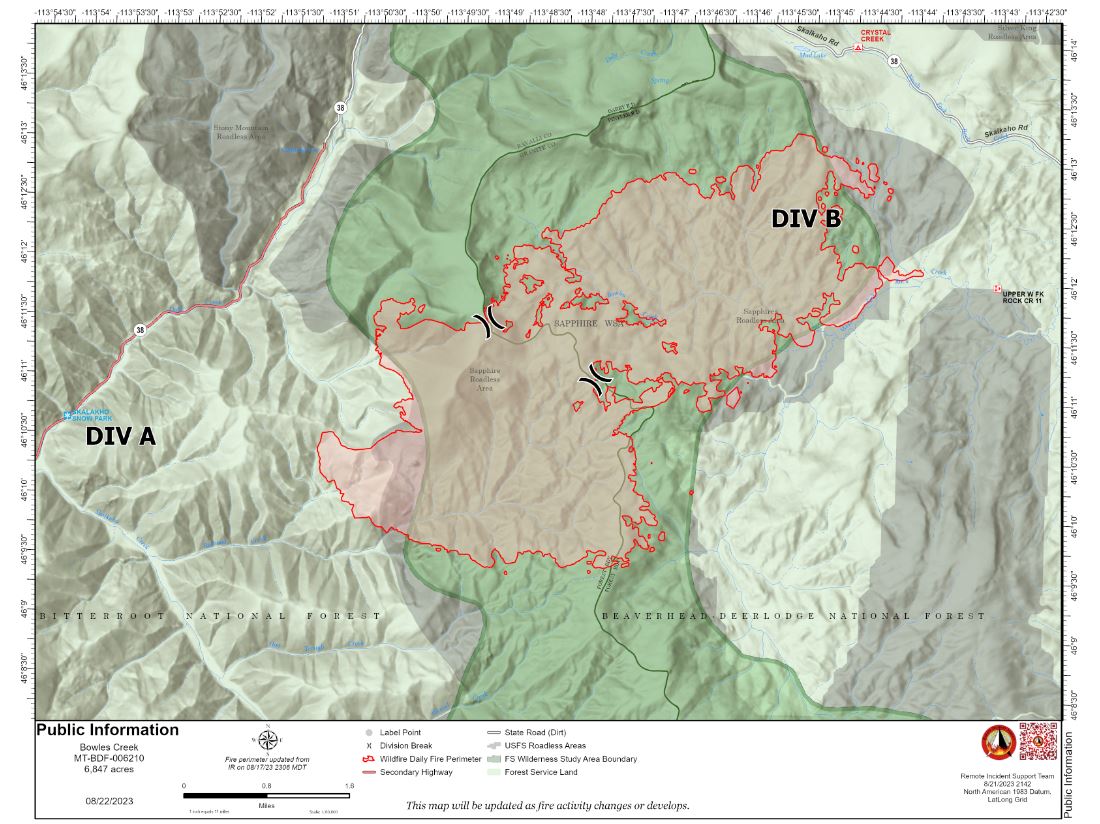
Bowles Creek Fire Daily Update August 22 2023
Related Incident: Bowles Creek Fire
Publication Type: News
The Nevada Team 3 Incident Management Team is managing the Bowles Creek Fire. The Bowles Creek Fire is currently at 6,847 acres. After several days of rain, the area will have a few days of drying, which may increase fire activity and cause smoke to impact nearby roads. Motorists traveling on Hwy 38, Skalkaho Road, should be aware firefighters continue to be present along the roadway and to drive with caution.
Point protection and confinement are the suppression strategies being used due to values at risk and safety concerns. Fire crews continue to construct fuel breaks along roads and other values at risk. Fire officials continue to analyze and assess fire behavior as weather conditions change. Firefighters are utilizing firing operations and fuels reduction work to strengthen lines and continue to monitor values at risk.
The fire completion remains at 20% as the objectives of confinement and point zone protection continue. Percent completion of objectives more accurately captures and reports the specific amount of work accomplished on the ground to manage fire spread and reduce the negative impacts to communities, infrastructure, and other identified values. By using percent completion of objectives, fire managers can better illustrate how accomplishment of identified objectives and priorities are progressing.