
Gray Fire Daily Update 082123
Related Incident: Gray Fire
Publication Type: News
The Gray Fire started August 18 near Gray Road west of Medical Lake and quickly spread to the east and southeast, through Medical Lake and across I-90. Level 3 evacuations remain in place for the Medical Lake area. Unauthorized entry hinders the work of firefighters. Emergency personnel are asking residents to respect evacuation areas as crews work to make reentry safe again.
Northwest Incident Management Team 7 assumed management of the Gray Fire this morning from Northeast Washington Interagency Incident Management Team 1.
Today’s Activities: As fire activity moderates with limited fire growth expected today, firefighters are able to make increased progress strengthening containment lines and mopping up along the fire perimeter. Fire crews are constructing handlines to connect sections of dozer lines together and strengthen containment lines. Firefighters are also moving into the interior of the fire to mitigate unburned pockets of fuel.
Crews are working within the fire perimeter to secure unburned structures and reduce risk from hot spots. Additional strike teams of engines are dedicated to responding to emergency calls about possible new concerns near structures within the fire perimeter. Power utilities are making progress restoring power poles and lines.
Weather: Relative humidity levels should rise throughout the day, leading to a probability of light rain in the afternoon or evening. While the rain may not be a “wetting rain” over the fire, it will help reduce fire growth. This weather system should moderate temperatures for the next few days.
Evacuations: Spokane County Emergency Management have reduced the evacuation levels for a portion of the area as of August 21 at 12:01 a.m. Evacuation maps are posted on the Gray Fire Inciweb page and the Spokane County Emergency Management Facebook page: https://www.facebook.com/GEGEmergencyMgt.
The Red Cross shelter for people and their pets is located at Spokane Falls Community College. The Spokane County Fairgrounds is available to shelter large animals or livestock from evacuated areas.
Interstate 90: I-90 remains closed between Tyler (milepost 257) and Four Lakes (milepost 270) due to active burning and hazard trees that may fall on the roadway. WSDOT and NW Team 7 are making progress assessing and clearing these hazards today. There is no estimate for I-90’s reopening, but WSDOT will post any changes on their website and social media accounts promptly when they occur. State Hwy. 904 has reopened and is the primary detour route.
ADDITIONAL FIRE & EMERGENCY INFORMATION:
Gray Fire Information:
Phone: 509-903-5563
Inciweb: https://inciweb.nwcg.gov/incident-information/wanes-gray-fire
Facebook: https://www.facebook.com/newfireinfo
Washington Smoke Blog: https://wasmoke.blogspot.com/
Spokane County Emergency Management (Evacuations): https://www.facebook.com/GEGEmergencyMgt
Local Red Cross Support: https://www.redcross.org/donate/donation.html
WA DOT Highway Updates: https://twitter.com/WSDOT_East or
https://wsdot.com/Travel/Real-time/Map/
Fire Update Smith River Complex AM 821
Related Incident: Smith River Complex
Publication Type: News
Gasquet, Calif., August 21st, 2023 —Due to the complexity and expansive geographic area of the Smith River Complex, Pacific Northwest Incident Management Team 13 (NWIMT-13) has joined with California Interagency Incident Management Team 15 (CAIIMT-15) to manage the emerging incident. The addition of NWIMT-13 will be beneficial in providing management of resources assigned to the northern reaches of the Complex to aid in fire suppression activities and improved safety. CAIIMT-15 will continue suppression efforts on fires south of the California/Oregon border. Both teams will be working closely together as they share a mutual interest to provide for the safety and welfare of the affected public and firefighting personnel.
The Smith River Complex is approximately 30,392 acres with zero percent containment. A Red Flag Warning was issued yesterday for strong, dry, northeasterly winds which also prompted a new evacuation of the Gasquet community. Remote weather stations confirmed strong winds occurred on the upper elevations overnight, but fortunately never surfaced along the Smith River corridor, causing the fire to remain at the upper elevation and avoiding an imminent threat to the communities. Beginning Tuesday, weather is predicted to moderate with cooler temperatures. This cooling trend along with smoky conditions may reduce fire behavior across the complex. An infrared flight occurred yesterday evening and it confirmed that the Holiday and Kelly fires have merged. Going forward, the combined fire will be referred to as the Kelly Fire. Highway 199 remains closed. Pacific Power transmission lines continue to be threatened by the fires, as well.
Additional resources will continue to arrive to the incident, including six strike teams of both structure and wildland engines. These engines will be incorporated into the suppression efforts to protect communities and critical infrastructure. Additional engines and hand crews are expected to arrive over the next several days. Law enforcement personnel from multiple jurisdictions are also assisting with incident safety and security. There are currently over 850 total personnel on scene with many more expected to arrive over the next several days.
Evacuations
All evacuation orders are issued by the Del Norte County Sheriff's Office. If you are in the Del Norte County, area please sign up for their Community Alert System to receive emergency notifications. Evacuation levels as of 8:00 am today August 21st are as follows:
Level 3 “Go Now”: Patrick Creek, Little Jones Creek, Copper Creek Drainage, Coon Creek/ 16n19 17n07, Washington Flat, Pioneer Road, Panther Flat Campground Area, all communities between Slant Bridge Road north to the Oregon Border along Highway 199, French Hill Road.
Level 2 “Be Set”: High Divide, Rowdy Creek, Big Flat/Rock Creek
Level 1 “Be Ready”: Low Divide, Hiouchi from Slant Bridge to the east end of North Bank Road
Closures
Howland Hill Road (Residents Only)
County road 316, Shelly Creek,
County Road 315 Holiday Mine
County Road 311 Old Gasquet Toll Road
Forest Service Roads 16N19 and 17N07
U.S. Highway 199 is fully closed in Del Norte County from Slant Bridge Road to Oregon Mountain Road (PM 16 to 31) due to the fires. A hard closure is in place on U.S. 199 at the Agriculture Station near the Oregon border. For the latest road conditions please visit quickmap.dot.ca.gov
Effective Sunday, August 20, 2023, the Six Rivers National Forest has issued a forest-wide closure order. https://www.fs.usda.gov/detail/srnf/notices/?cid=FSEPRD1096395
The American Red Cross has opened a shelter at the Del Norte County Fairgrounds (421 US-101 N, Crescent City, CA 95531) for those who are displaced by evacuations. Red Cross disaster workers are partnering with local officials to help ensure evacuees receive basic necessities, including food, water and shelter.
Please refer to the following social media for additional information:
Smith River Complex Inciweb: inciweb.nwcg.gov/incident-information/casrf-smith-river-complex
Facebook: Six River National Forest: https://www.facebook.com/SixRiversNF
Del Norte Office of Emergency Services: https://www.facebook.com/DelNorteOfficeOfEmergencyServices
Del Norte County Sheriff’s Office: https://www.facebook.com/DelNorteCountySheriffDepartment
Josephine County Emergency Management: https://www.facebook.com/josephinecountyEM
Rogue River-Siskiyou National Forest: https://www.facebook.com/R6RRSNF/
2023 SRF Lightning Complex and Redwood Lightning Complex Update 82123
Related Incident: 2023 SRF Lightning Complex and Redwood Lightning Complex
Publication Type: News
2023 Six Rivers National Forest Lightning Complex
August 21, 2023 – California Incident Management Team 2 is in command of the Six Rivers National Forest (SRF) 2023 Lightning Complex which includes the Lone Pine, Pearch, Mosquito, Blue Creek, Blue Creek 2, Bluff #1, Let-er-buck, and Iron fires in addition to Redwood National and State Parks wildfires; Lost, Devil and Glenn Fires.
Redwood National and State Parks Area
Lost – 0% contained. Full suppression tactics continue on the Lost Fire, estimated at 351 acres. The fire is located in the Lost Man Creek watershed west of Holter Ridge Road and south of the Lost Man Creek Trail/Geneva Road. Crews are working to prevent the fire from entering old growth forest and adjacent private timberland. CAL FIRE and Green Diamond Resource Company are collaborating with suppression efforts on the Lost Fire.
Devil 12 acres contained and in patrol status Glen 0.1 contained and in patrol status.
Hoopa Area
Lone Pine - Located south of Hoopa in the Horse Linto Creek watershed east of the Trinity River and across the river from Tish Tang Campground and Sugar Bowl Ranch, fire size is estimated at 1,624 acres. Crews are pushing the fire toward the mainstem Trinity River into a planned backing alignment while holding and monitoring current lines.
Orleans Area
Pearch - East of Orleans is estimated at 981 acres, has resumed a backing alignment after making a northeast run towards Somes Mountain. The fire pushed toward north fork Boise Creek, staying south of Pearch Creek and north of South Fork Pearch Creek. Fire lines established in 2006 are being utilized as the fire moves towards Somes Mountain. The Orleans pumphouse has been prepped with structure wrap.
Pearch Fire Evacuation Warning:
Orleans
Zone HUM-E009 (Southeast of the Klamath River in Orleans)
Zone HUM-E008-B (Community of Orleans, west of Klamath River. East of Crawford Creek, including Orleans proper). Hwy 96 and Red Cap Road along east bank of Klamath River, south from Salmon River, east to Orleans Mountain.
Approximately 243 residents live in these 2 zones.
Somes Bar
Zone SIS-1701: NORTH of Monte Creek Road, SOUTH OF Camp Three Road, EAST OF Camp Three Road, WEST OF Wooley Creek Trailhead. Anyone in these areas should be prepared for potential evacuations, including personal supplies and overnight accommodations. Be ready to go at a moment's notice.
Iron - Located above Ti-Bar Wildland Fire Station, this fire has been contained at 17 acres.
Mosquito - Near the Bluff Creek area north of Mosquito Lake is estimated at 1,061 acres. The fire remains north of Forest Road 11N19 and west of Forest Road 12N12. Two engines, one water tender, one dozer, and one division are on site. Smoke jumpers are also on site.
The following fires are currently unstaffed due to limited resources. Additional resources are on order.
Bluff #1 - 56 acres Blue Creek - .1 acre Blue Creek 2 - 318 acres Let er-Buck - 32 acres
Total estimated acreage for the SRF Lightning Complex is 3,091 acres.
Weather
The remnants of tropical storm Hilary will move out of the area today however clouds and a few showers are possible until the early afternoon. Breezy northeast winds will diminish through the day then become northwesterly. Clouds and lingering moisture will keep humidity levels higher and daytime temps lower. Today will see a 10% chance of isolated showers, with cooler and drier air along the ridges above the smoke inversion.
Six Rivers National Forest Closures
Closures are in effect on Six Rivers National Forest. They may be found at: https://www.fs.usda.gov/detail/srnf/notices/?cid=FSEPRD1096395. Outdoor activities are not recommended due to wildfire danger and unhealthy air quality.
Redwood National Park and State Parks Closures
Due to fire activity in the area, Lost Man Trail from the trailhead on Bald Hills Road to the gate at the Lost Man Picnic Area is closed. Lost Man Road will remain open from Hwy 101 to the Lost Man Picnic Area.
Alert Notifications
- ZoneHaven/Genasys for map and zone identification: https://protect.genasys.com
- Humboldt County resident emergency alert sign up: www.humboldt.gov/alerts
- Siskiyou County resident emergency alert sign up: https://public.coderedweb.com/CNE/en-US/6F327CCDFFFD
For more information:
Redwood National and State Parks Information Hotline
Phone: 707-464-6101
2023 SRF Lightning Complex Fire Information
Phone: 530-330-4048
Email: 2023.lonepine@firenet.gov
Hoopa Information Hotline
Phone: 530-618-2995
Email: serene.oes@gmail.com
For list of more information resources visit: linktr.ee/srffirepio
21 de agosto 2023 Informacin al da para el Incendio Flat
Related Incident: Flat Fire
Publication Type: News
Extensión: 34,242 acres
Fecha de Inicio 15-julio-2023
Origen: 2 millas Suroeste de Agness, OR
Contenido: 58%
Personal: 479
Recursos: 17 camiones de bomberos l 12 escuadrillas de bomberos l 4 buldóceres l 17 cisternas l 17 máquinas masticadoras l 4 helicópteros
Aspectos destacados: El fuego continúa ardiendo y arrastrándose entre los combustibles interiores. Persisten bajas tasas de propagación del fuego en las islas no quemadas dentro del perímetro. Se está produciendo un pequeño número de incendios de árboles individuales en estas islas, pero no se espera que amenacen las líneas de contención. El equipo sigue centrándose en la identificación de las condiciones de comportamiento del fuego que podrían dar lugar a una rápida propagación del incendio. Estos indicadores son específicamente condiciones de viento y alineación de laderas en drenajes y vientos en crestas y se consideran críticos en cualquier situación de incendio forestal. La principal herramienta de lucha contra incendios en este esfuerzo es la evaluación visual constante de las líneas de fuego y las fuentes de calor aisladas. El humo del Complejo Smith River está afectando a varias operaciones de lucha contra incendios aéreas y terrestres, así como a las comunidades locales. Los recursos continúan apoyando los incendios en los alrededores.
Actividades de hoy: Los bomberos están presionando para alcanzar el objetivo de supresión completa para el Incendio Flat. Los recursos terrestres y/o aéreos se están concentrando en identificar cualquier comportamiento amenazante del incendio mediante evaluaciones visuales constantes de la actividad del incendio. Las cuadrillas del Grupo de Combustibles que construyen líneas manuales en el drenaje del río Pistol están a punto de finalizar el proyecto de línea de contingencia del nivel sur. La trituración y la retirada de madera continuarán mientras los bomberos tratan de mejorar las nuevas líneas de contingencia contra la expansión del fuego impulsado por el viento. La mejora de estas líneas es una prioridad para alcanzar un estado final aceptable y lograr el objetivo de supresión total. Se están explorando otras posibilidades de contingencia en los lugares en los que se prevé que la actividad del fuego supondrá una mayor amenaza. Se dispone de recursos aéreos para apoyar los esfuerzos de ataque inicial según sea necesario.
El tiempo: Las temperaturas están bajando hoy y seguirán bajando a lo largo de la semana, lo que debería ayudar en la lucha contra el fuego. El aumento de la humedad relativa seguirá frenando el comportamiento activo del fuego. Hay un 5-10% de probabilidad de chubascos aislados o tormentas eléctricas.
Humo: El humo de los incendios de los alrededores seguirá afectando a los esfuerzos de extinción de incendios y las comunidades locales según lo dictado por las condiciones del viento. La Perspectiva de Humo está disponible en: Current Smoke Outlook for SW Oregon/NW California (wildlandfiresmoke.net)
Cierres: Cierres: U.S. Highway 199 ha sido cerrada al norte de Gasquet debido a los incendios en el Six River National Forest, por favor utilice U.S. Route 101 a SR 42s para todos los viajes hacia y desde el Rogue Valley. Servicio Forestal y BLM carreteras no deben utilizarse como rutas alternativas debido a la actividad del fuego. El Bosque Nacional Rogue River-Siskiyou (RRSNF) ha emitido una orden de cierre de la zona del incendio, incluyendo senderos, carreteras y una parte del río Illinois. Visite Rogue River-Siskiyou National Forest - Alerts & Notices (usda.gov) para más información.
Evacuaciones: Estado de evacuación de nivel 1 "Prepárense" para las zonas cercanas al Flat Fire. Enlace a más información: Welcome to Curry County, OR
Restricciones: El peligro de incendio es actualmente extremo; la RRSNF está aplicando Restricciones de Uso Público de Nivel 3. El RRSNF, el BLM de Medford y el ODF han aplicado restricciones de uso público de nivel 3 en la sección salvaje del río Rogue. Para más información: https://tinyurl.com/ueuznr6e\
Flat Fire Morning Update 08212023
Related Incident: Flat Fire
Publication Type: News
Size: 33,242 acres
Start Date: July 15, 2023
Point of origin: 2 miles southeast of Agness, OR
Containment: 58%
Total personnel: 512
Resources: 17 engines l 12 crews l 4 bulldozers l 17 water tenders l 17 masticators l 4 helicopters
Highlights: Fire behavior continues smoldering and creeping among interior fuels. Low rates of fire spread persist in the unburned islands within the perimeter. A small number of single tree torching in these islands is occurring but is not expected to threaten containment lines. The team continues to focus on identifying fire behavior conditions that could result in rapid fire spread. These indicators are specifically wind and slope alignment conditions in drainages and ridge-top winds and are considered critical in any wildfire situation. The primary firefighting tool in this effort is the constant visual assessment of the fire lines and isolated heat sources. Smoke from the Smith River Complex is impacting various air and ground fire operations as well as local communities. Resources continue to support fires in the surrounding area.
Today’s Activities: Firefighters are pressing forward to reach the full suppression objective for the Flat Fire. Ground and/or aviation resources are concentrating on identifying any threatening fire behavior using constant visual assessments of the fire activity. Fuels Group crews constructing hand line in the Pistol River drainage are nearing completion of the southern tier contingency line project. Chipping, brushing, masticating and timber removal will continue as firefighters look to improve the new lines for contingency against wind driven fire expansion. Improving those lines is a priority to reach an acceptable end state and achieve the full suppression objective. Additional contingency opportunities are being explored where future fire activity can be anticipated to pose the greatest threat. Air resources are available to support initial attack efforts as required.
Weather: Temperatures are cooling today and will continue to trend cooler throughout the week which ought to aid firefighting efforts. Higher relative humidity will continue to slow active fire behavior. There is a 5-10% probability of isolated showers or thunderstorms.
Smoke: Smoke from the surrounding area fires will continue to impact firefighting efforts and local communities as dictated by wind conditions. The Smoke Outlook is available at: Current Smoke Outlook for SW Oregon/NW California (wildlandfiresmoke.net)
Closures: U.S. Highway 199 has been closed north of Gasquet due to fires on the Six River National Forest, please use U.S. Route 101 to SR 42s for all travel to and from the Rogue Valley. Forest Service and BLM roads should not be used as alternate routes due to fire activity. The Rogue River-Siskiyou National Forest (RRSNF) has issued a closure order for the fire area including trails, roads, and a portion of the Illinois River. Visit Rogue River-Siskiyou National Forest - Alerts & Notices (usda.gov) for more information.
Evacuations: Level 1 “Get Ready” evacuation status in place for areas in the vicinity of the Flat Fire. Link to more information: Welcome to Curry County, OR
Restrictions: Fire danger is currently extreme; the RRSNF is implementing Level 3 Public Use Restrictions. Level 3 PURs on the Wild Section of the Rogue River have been implemented by the RRSNF, Medford BLM and ODF. More information: Rogue River-Siskiyou National Forest - News & Events (usda.gov)
August 21 2023 Daily Update
Related Incident:
Publication Type: News
Cooler temperatures and high amounts of moisture persisted all day Sunday. Fire managers saw moderated fire activity. With increasingly inclement weather moving into the area and a flood watch issued through midnight tonight, crews will be staged at camp. They will remain in a ready state at camp until conditions improve to a point where it is deemed safe enough for them to return to the fire area.
With the current minimal spread, the values threatened still include the East Mountain communications infrastructure, timber sales, trail systems, and private timber lands.
Weather: Moderate to heavy rains are expected moving through the area today with gusty winds possible. Tropical moisture will continue to push northward through the fire area bringing showers and occasional heavy rain. These conditions may linger through Tuesday.
Closure Area: In place for public safety and details including a map can be found on the East Fire InciWeb page and the forest Facebook page.
Air Quality: http://idsmoke.blogspot.com/
Web: https://www.fs.usda.gov/boise/
Facebook: https://www.facebook.com/BoiseNationalForest
East Fork Fire August 21 2023 UPDATE
Related Incident: East Fork Fire
Publication Type: News
East Fork Fire - Update August 21, 2023
NORTHERN ROCKIES TEAM 6
INCIDENT COMMANDER: Paul Roose
Kootenai National Forest/Flathead National Forest
Fire Information 406-285-8634 Eastforkfireinfo@gmail.com
https://inciweb.nwcg.gov/incident-information//mtknf-east-fork-fire
Location: 12 miles south of Trego, MT
Start Date: 7/30/2023 Cause: Lightning Size: 4,614 acres Containment: 5%
Total Personnel: 556 Engines: 12 Hand Crews: 10
Yesterday’s Events: At 2:00 PM, August 20th, the Evacuation Order issued on August 18, 2023, was downgraded back to a pre-evacuation warning. Smokey conditions continued to reduce fire behavior and limit spread. Personnel took advantage of these conditions to continue to extinguish hot spots along the burned edge on the southwest side of the fire. In addition, crews made progress on the north side of the fire lines focusing on areas with significant heat/spot fires. Aircraft including the super scoopers, operated in the afternoon operate to reduce fire spread into Martin Creek. Engine crews, assisted by helicopter bucket drops, contained hot spots in the Martin Creek area. CL 415 Scoopers dropped approximately 70,000 gallons of water yesterday. Scouting for additional contingency lines continues on the active fire front.
Plans for Today: With the remnants of Hurricane Hillary, ½ -1inch of rain is expected over the next 36 hours, with heavy downpours. This weather system is considered to be a “season slowing” event and not a “season ending” event. Extended forecast calls for a return to drier conditions later in the week. Based on weather conditions, personnel will continue operations and air support will be provided as weather permits. Crews will search for opportunities to move closer to the fire to construct fire lines and will seek out and extinguish all hot spots.
Evacuations: Some communities remain in a Pre-Evacuation Warming. Residents may return to their homes under Pre-Evacuation Warning but may need to leave again on short notice if required. For more information, go to the Sheriff’s Department website.
Public Meetings: A public meeting will be held at 7:30 PM, Tuesday, August 22, at the Olney-Bissell School. The video from Friday nights’ town hall meeting can be found on YouTube (https://youtu.be/XgXP_s3I4Y4). Information and fire videos can also be found on the Kootenai and Flathead National Forests’ Facebook pages.
Lookout Fire Morning Update 8212023
Related Incident: Lookout Fire
Publication Type: News
Lookout Fire
August 21, 2023
Morning Update
Size: 11,174 acres
Start Date: August 5, 2023
Cause: Lightning
Containment: 5%
Point of origin: 3 miles North of McKenzie Bridge, OR
Total personnel: 1,061
Resources: 65 engines l 19 crews l 13 bulldozers l 27 water tenders l 11 masticators l 7 helicopters
OSFM Resources: 5 task forces assigned to structure protection divisions
Current Situation: Fire activity was moderate on the Lookout Fire yesterday, with heavy smoke and light winds persisting into the evening. Cooler temperatures, higher humidity, and a slight chance of light rain is forecast for Monday and Tuesday before a warming trend returns on Wednesday.
Firefighters have established an anchor point on the fire’s southwest corner along the 700 Road. Hand crews, fire engine crews, tree-falling modules, masticators, feller-bunchers and bulldozers are clearing hazard trees and vegetation along Road 2633 and working to the north. Burning operations to secure these roads will take several days to complete.
Most of the fire’s spread is occurring on its eastern flank where the fire is backing downslope toward Deer Creek Road. Firefighters, fallers, and heavy equipment are working to clear vegetation along this road to help impede the fire’s progress toward Highway 126. Crews are installing pumps and hose along the McKenzie River where necessary to check the fire’s spread and protect values at risk such as homes and infrastructure.
An Unmanned Aerial System (UAS) or drone module is providing aerial reconnaissance to firefighters in the form of infrared (IR) imaging or scouting for spot fires over control lines. UAS are also integral to burning operations - they are capable of dropping incendiary “spheres” resembling ping pong balls, limiting the risks associated with helicopter-dependent firing operations. Unlike helicopters, UAS can also fly in areas of heavy smoke.
To relieve congestion at the command post at the McKenzie River airstrip, an additional incident base of operations is now in place in Walterville. Motorists are advised to use caution as an increase in fire vehicle traffic is occurring in the Camp Creek Road area and along Highway 126.
Oregon State Fire Marshal (OSFM) task forces continue to assist our wildland partners in holding the fire north of the 700 road, along the southern edge of the fire. Structure prep is complete throughout the Level 3 evacuation zone and crews will continue to patrol these locations, monitoring the effectiveness and operability of existing efforts. Placarding and preparatory work continues along Highway 126, in lower-level evacuation zones. Work will continue at key resource and critical infrastructure locations within the eastern evacuation zones.
California Office of Emergency Services (Cal-OES) task forces will begin demobilizing this morning. The immediate response of these resources contributed to the rapid completion of preparatory work. Structure crews continue to complete tactical patrols around the clock, with two task forces assigned to day shift and three at night.
Evacuation Centers: An evacuation center is in place at Lowell High School for evacuees and small pets from the Bedrock and Lookout Fires. A large animal shelter is set up at the Lane County Fairgrounds in Eugene.
Evacuations: In Lane County, there is a Level 3 (Go Now) evacuation notice for Taylor Rd., North Bank Rd., all areas north of Highway 126 between Blue River Reservoir Rd. and Drury Ln., the area south of Highway 126 to the McKenzie River from the east end of McKenzie River Dr. to the McKenzie River Bridge just east of Taylor Rd., Mona Campground, Lookout Campground, H.J. Andrews Headquarters and the area west of Highway 126 from Scott Rd. north into Linn County. There is a Level 2 (Be Set) from Highway 126 from the Highway 242 junction to Scott Rd., Paradise Campground, FS Rd. 302, Belknap Springs Rd. S., Belknap Hot Springs Rd., the area east of Highway 126 from Scott Rd. north into Linn County. There is a Level 1 (Be Ready) evacuation notice for areas south of Highway 126 from Blue River Reservoir Road east to Foley Ridge Road., McKenzie River Dr., Highway 242 to FS Road. 220, Yale Ln., Camp Yale Road., FS Road. 2643 southeast to the 445 spur road. Residents of Horse Creek Road and King Road remain in a Level 1 evacuation notice.
For current evacuation updates please see Lane County’s website at: https://www.lanecountyor.gov/cms/one.aspx?pageId=19729054
In Linn County, there is a Level 3 (Go Now) for Olallie Campground, Trail Bridge Reservoir & Campground, and the trail systems and roadways north of the Linn County line, and west of Highway 126, extending north to intersection of National Forest Service Road 730 and Highway 126.
A Level 2 (Be Ready) for the area from the east side of Olallie Campground east to the Willamette National Forest Boundary, north along boundary to Ice Cap Campground and Trailhead, then west to encompass Lakes End Campground and trail system, and south in line with the intersection of National Forest Service Road 730 and Highway 126 (entrance to the Carmen-Smith Hydroelectric facility). Tamolitch Falls/Blue Pool and Smith Reservoir are within this Level 2 (be set) Evacuation Zone.
Level 1 (Be Ready) evacuation zone for areas north of Ice Cap Campground, extending east to the Willamette National Forest boundary, and north in line with Highway 20. This includes all areas around Clear Lake, and Clear Lake Campground. For current information please see Linn County’s website at: https://www.linnsheriff.org/2023/08/lookout-fire-update-august-17-2023-330-p-m/
Closures: Highway 242, McKenzie Highway, is closed between milepost 61-76, 14 miles west of Sisters, Oregon to just east of the junction with Highway 126. Highway 126 is currently open. Please monitor Trip Check for any updates at: https://tripcheck.com/
Willamette National Forest closures can be found at: https://www.fs.usda.gov/detail/willamette/alerts-notices/?cid=fseprd552029Restrictions: Fire Restrictions are in place on the Willamette National Forest: https://www.fs.usda.gov/willamette
Smoke Outlook: Smoke outlooks for Lookout Fire are available at: https://outlooks.wildlandfiresmoke.net/outlook/4c92bc1a?
Information Line: 541-215-6735 8am-8pm | Email: 2023.lookout@firenet.gov
Facebook: https://www.facebook.com/LookoutFire2023
Black Feather Fire Daily Update August 21 2023
Related Incident: Black Feather Fire
Publication Type: News
The Santa Fe National Forest Updates Black Feather Fire Closure Order
Update: Monday, August 21, 2023
Acres: 2,198 acres
Start Date: August 5, 2023
Cause: Lightning
Fuels: Timber, Brush, Understory
Containment: 28%
Resources: 155 personnel
Location: Approximately 9 miles south of Gallina, NM, on the Santa Fe National Forest, Coyote Ranger District. Near the Peñas Negras Trail in the San Pedro Parks Wilderness.
Highlights: The Santa Fe National Forest has revised the area, road, and trail closures in the Coyote Ranger District. The updated order lifts restrictions on some of the roads impacted by the Black Feather Fire, including Road 103. See the full closure order to review specific locations that are open and those that remain closed at https://bit.ly/BlackFeatherClosureUpdate. Fire crews and heavy equipment continue to use local roads for active firefighting and suppression repair activities, including relying on Road 103 as primary means of entry and exit. Please use caution when traveling in the area.
Hotshot crews were able to reach portions of the fire within the wilderness, locating areas of more active fire and scouting locations that can safely be accessed for future suppression activities. Crews outside of the wilderness finalized chipping operations and continued to work on containment lines along the eastern edge of the fire.
Operations: Today, suppression efforts will continue within the wilderness and along the eastern edge of the fire. Crews will utilize an infrared drone to help identify areas with greater fire activity and focus their efforts on those locations. With heavy dead, down and standing timber in the wilderness, fire managers are carefully monitoring suppression activities in relation to weather and fire behavior to ensure incident objectives are met while remaining focused on firefighter safety.
Safety: Equipment and fire crews are actively moving in and around the fire area, including roads reopening today. Please use caution when traveling around the Black Feather Fire. The Temporary Flight Restriction is still in place. Please do not fly drones anywhere near the fire. If you fly, we can’t fly.
Weather: Mostly sunny then becoming partly cloudy in the afternoon with scattered showers and thunderstorms. Highs will be in the low 70s. Warm, dry, breezy and unstable conditions persist, but a gradual moistening trend is forecast early week that will bring humidity up and also bring back chances for wetting storms.
Restrictions/Closures: Effective Monday, August 21, the Santa Fe National Forest has issued an updated area, road, and trail closure in part of the Coyote Ranger District. See https://bit.ly/BlackFeatherClosureUpdate for information and a corresponding map. Forest Road 103 is now open. Closures will be adjusted based on fire activity.
Smoke: Variations in temperatures, humidity & fire activity will impact smoke conditions in the coming days and weeks. Smoke may be more and less visible in the area as active smoldering takes place. Smoke-sensitive individuals and people with respiratory problems or heart disease are encouraged to take precautionary measures. Air quality information is available at https://www.airnow.gov/.
Evacuations: The communities of Mesa Pinabetal, Mesa Poleo, and Wetherill remain in ‘Ready’ status. The Coyote Senior Center is open to evacuees, and livestock can be taken to the Rio Arriba Rural Event Center near Abiquiu. The Rio Arriba County Sheriff’s Office will coordinate evacuations if they go into effect. For more information, use the QR code below and visit the Sheriff’s Office Facebook page: https://www.facebook.com/profile.php?id=100079688263048.
Fire Information: 505-460-0499 – 2023.blackfeather@firenet.gov
Facebook: https://www.facebook.com/blackfeatherfireinfo
New Mexico Fire Information: https://nmfireinfo.com/
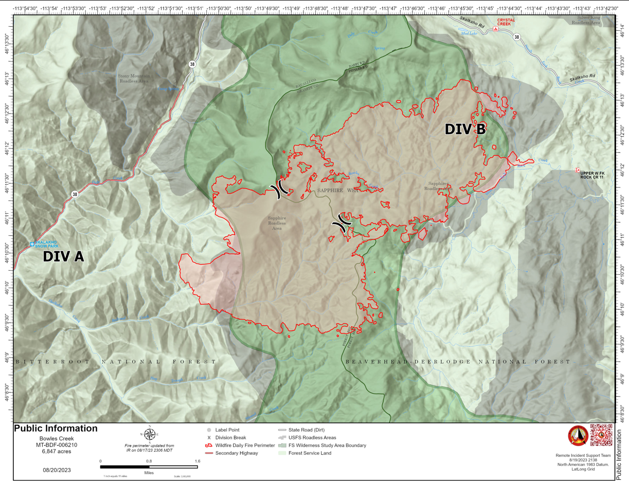
Bowles Creek Fire Update August 21 2023
Related Incident: Bowles Creek Fire
Publication Type: News
The Nevada Team 3 Incident Management Team is managing the Bowles Creek Fire.
The Bowles Creek Fire is currently at 6,847 acres. Motorists traveling on Hwy 38, Skalkaho Road, are urged to drive with caution as firefighters will be present along the roadway.
Fire crews continue to construct fuel breaks along several roads and other values at risk. Fire officials continue to monitor fire spread and fire behavior as weather conditions change. Firefighters are utilizing firing operations and fuels reduction work to strengthen containment lines and continue to monitor values at risk for spotting and fire spread.
The fire completion remains at 20% as the objective of confinement and point zone protection continues. Percent completion of objectives more accurately captures and reports the specific amount of work accomplished on the ground to manage fire spread and reduce the negative impacts to communities, infrastructure, and other identified values. By using percent completion of objectives, fire managers can better illustrate how accomplishment of identified objectives and priorities are progressing.