
2024 SQF Lightning Daily Incident Update 07 30 2024
Related Incident: 2024 SQF Lightning
Publication Type: News
Trout Fire: 23,369 acres - 33% containment
Long Fire: 9,204 acres - 95% containment
Borel Fire: 57,306 acres - 17% contained
Total Personnel: 1,059
For more information on the Borel Fire, visit: https://inciweb.wildfire.gov/incident-information/casqf-borel-fire
Current Situation: The Borel Fire has burned over 57,306 acres in five days. As fire crews come off the line this morning, others who are rested and ready to battle the fire will replace them. The Borel Fire has burned with extreme intensity and negatively impacted communities. In its aftermath, thorough inspections of all damaged or destroyed structures will be conducted, ensuring every affected home and structure is carefully documented. This compassionate approach will help us make informed decisions for swift and efficient recovery, providing the necessary resources and support to those in need. Ensuring the safety of residents and protecting property remain top priorities. KRN-100-B, 102-B, 419 and 744 have been placed under an Evacuation Warning. Evacuation warnings and orders enhance safety for residents and allow emergency personnel to concentrate on controlling the fire. Residents can check the status of their zone using Genasys Protect's interactive map at tinyurl.com/jcdv55f9. The Borel fire is under a unified command led by the California Interagency Incident Management Team (CIIMT) 11, and the Kern County Fire Department.
Borel Fire: The Borel Fire has slowed its progression due to a change in fuel complexion as vegetation goes from dry grass to green brush as well as mountains, rocky terrain to the east. The southern edge of the fire is north of Walker Basin, where crews constructed handline to hold the fire in its current footprint. In the northern section, crews used both direct and indirect tactics to establish a contingency line off of Kern Canyon Road, holding the fire south of Sandy Dip. On the eastern section of the fire, aerial resources, including helicopters and air tankers, are supporting ground crews in slowing the fires progression near Libel Peak. Firefighters are focusing on protecting structures and establishing containment lines around the most active fire fronts. Today, fire behavior is expected to be moderate with higher humidity and wind gust up to 25 mph on the peaks.
Trout Fire: Fire growth was minimal on Monday with dry, warm and windy conditions. Crews to make progress in suppressing hot spots along the fires edge. On the southern perimeter, crews continue to camp near the fireline in the Domeland Wilderness to extinguish lingering areas of heat and construct fireline with hand tools from Sirretta Pass toward Smith Meadow.
Long Fire: Fire activity remains minimal with containment at 95 percent.
Weather & Air Quality: Cooler, humid conditions are expected today with wind gusts up to 25 mph. Westerly winds will remain elevated on ridgetops throughout Sunday night. A daily smoke outlook is produced for communities affected by wildfire smoke: tinyurl.com/452x2uzr.
Sequoia National Forest & BLM Closures & Restrictions: Sequoia National Forest lands, roads, trails, and recreation sites around the Trout and Long Fires are temporarily closed under Forest Order No. 0513-24-12. Lands, roads, trails, and recreation sites around the Borel Fire are closed under Forest Order No. 0513-24-14. Fire restrictions are in effect under Forest Order No. 0513-24-10. All orders, maps, and accompanying appendices can be found on the Forest’s website: tinyurl.com/2en2d36k. The Bureau of Land Management Bakersfield Field Office has temporarily closed Long Valley Campground, Chimney Creek Campground, and portions of the Pacific Crest Trail (PCT). View the emergency closure order here: tinyurl.com/4mprcb9b. The PCT is closed between Hwy 178 at Walker Pass (mile 653) and the South Fork of the Kern River bridge (mile 717.7).
Evacuation Center: Residents under an evacuation warning or order can go to either the Tehachapi Education Center (126 S. Snyder Ave., Tehachapi) or Burroughs High School (500 E French Ave, Ridgecrest). Animal services are available to assist in sheltering companion animals at the center. Contact the American Red Cross at 1-800-733-2767.
Large-Animal Assistance: The rodeo grounds in Kernville (467 Scodie Ave., Kernville) is available for residents who need to move large animals or livestock. For more information, contact Orion, Kernville Chamber of Commerce, 661-340-0026.
Road Closures: State Route 178 is closed from 4.1 mi east of the junction of SR 184 to Democrat Springs. View the interactive Caltrans map for the most current road closure information: quickmap.dot.ca.gov/. Portions of Caliente Bodfish Road are also closed. Visit the Kern County Public Works Department website for the most up to date information on county road closures (tinyurl.com/z6crvp6t)
Evacuations: Everyone in areas of active fires should “Know Your Zone.” Go to Genasys Protect (tinyurl.com/jcdv55f9) to identify the zone you reside in.
- Kern County has multiple evacuation orders and warnings in effect due to the Borel Fire. The following zones are under an evacuation order: KRN-403-A, KRN-403B, KRN-734, KRN-735, KRN-736, KRN-737, KRN-738, KRN-739, KRN-740, KRN-741, KRN-742, KRN-743, KRN-747-A, KRN747-B and KRN-748.
- The following zones are under an evacuation warning: KRN-100-B, KRN-102-B, KRN- 419, KRN- 729, KRN-730, KRN-731, KRN-732, KRN-733, KRN-744, KRN-749, KRN-750 and KRN-752
- Tulare County has evacuation warnings and advisories in effect due to the Trout and Long Fires. The following zones are under an evacuation warning: TLC-E274-B and TLC-E261-B. The following zones are under an evacuation advisory: TLC-E297-A, TLC-E250, TLC-E274-A, and TLC-E261-A.
Black Mountain Fire Update 11AM 07 30 2024
Related Incident: Black Mountain
Publication Type: News
Cooler temperatures and higher relative humidity Tuesday are all good news for the firefighters on the Black Mountain Fire. The fire is located about six miles northwest of Lincoln, Mont.
The fire exhibited little if any growth overnight and is still estimated at 65 acres.
Retardant and water drops Monday helped limit fire spread. Three air tankers are on the ramp in Helena ready to rejoin the suppression efforts.
The Bitterroot Hotshots arrived Monday night, and additional hand crews have been ordered.
Fire managers are looking to take advantage of an existing road and a mountain bike trail as they begin fireline construction.
The Pine Grove Campground remains closed. The Lewis and Clark County Sheriff’s Office has evacuations in place. The Montana Red Cross has set up an evacuation shelter at the Lincoln Public School building to serve those impacted by the fire.
The public can help the firefighting effort by staying out of the area and being aware of increased emergency vehicle traffic on area roads and highways.
Information will be updated on the Helena-Lewis and Clark Facebook page at https://www.facebook.com/HLCNF and on InciWeb at
https://inciweb.wildfire.gov/incident-information/mthlf-black-mountain
Easy Fire Update 07 30 2024
Related Incident: Easy Fire
Publication Type: News
Easy Fire Update for July 30, 2024
Incident Commander Lonnie Click
Complex Incident Management Team Northwest 3
(541) 861-5808, staffed 8 a.m. to 8 p.m. 2024.pioneer@firenet.gov
Quick Facts
Size: 528 acres*
Start Date: July 17, 2024
Location: 17 miles west of Mazama, WA
Containment: 0%
Personnel Assigned: 145
Cause: Lightning
Resources Assigned: 3 crews 5 engines
*no updated IR data due to weather conditions
CURRENT SITUATION: Yesterday brought minimal fire spread and small amounts of precipitation to the Easy Fire. Fire activity remains within the interior of the fire area with mostly smoldering fire and pockets of vegetation burning. The south side of the Easy Fire, crews worked to install and test 55 sprinklers that will support future strategic firing operations. Along the shoulders of State Route 20 firefighters cleaned-up debris and tree material that has rolled down from fire and suppression activity. Additionally, crews worked to improve indirect handlines, tying into the 2004 Mebee burn scar on the north side and avalanche chutes on the south side of the Easy Fire.
State Route 20 remains open to through traffic with a pilot car escorting vehicles through mileposts 148-157 from 7 a.m. to 8:30 p.m. daily. Expect 30 minutes delays as firefighters continue removing trees and debris from the roadway and conduct full suppression tactics on the Easy Fire. Please do not stop or pull over between mileposts 148-157. With wildfire and firefighting operations still active, the highway may need to close again on short notice. Be sure to check https://wsdot.com/Travel/Real-time/Map/ for the latest information on State Route 20.
TODAY’S ACTIVITIES: Fire activity is expected to remain moderate today with continued smoldering and pockets of vegetation burning within the fire area. Crews will review progress from Saturday’s strategic firing operations on the southeast side of the Easy Fire to determine potential opportunities for future aerial ignitions to further secure the fire on the ridgeline. Firefighters will evaluate and remove hazards such as standing dead trees along the indirect firelines on the north and south sides of the fire. Crews will continue work to remove debris and tree material from the shoulder of State Route 20.
The Easy Fire has a Temporary Flight Restriction in place for all aircrafts not involved in wildfire suppression operations. Do not fly a personal drone over or near the Easy Fire. Any incursions create a safety hazard to fire aircraft and require air operations to stop.
WEATHER: Temperatures today will increase to low to mid 80s. Sky weather is mostly cloudy with light rain in the morning and partly sunny conditions in the afternoon. Winds will be northwest 2-6 mph in the morning and increase to 8-10 mph in the afternoon.
CLOSURES: The Okanogan-Wenatchee National Forest has closures in place for trails within the fire area: https://bit.ly/EasyFireClosures. This closure includes a portion of the Pacific Crest Trail. Campfires are prohibited. There is a Temporary Flight Restriction (TFR) in place over the fire: https://tfr.faa.gov/save_pages/detail_4_6779.html. Unauthorized drone activity is prohibited under the TFR.
EVACUATIONS: There are no evacuations in place for the Easy Fire. Anyone recreating in the area should be vigilant of surroundings and stay out of closed areas.
Facebook: https://www.facebook.com/profile.php?id=61560760893080
Fire Information Line: 541-861-5808, 8 AM to 8 PM
Email: 2024.easy@firenet.gov
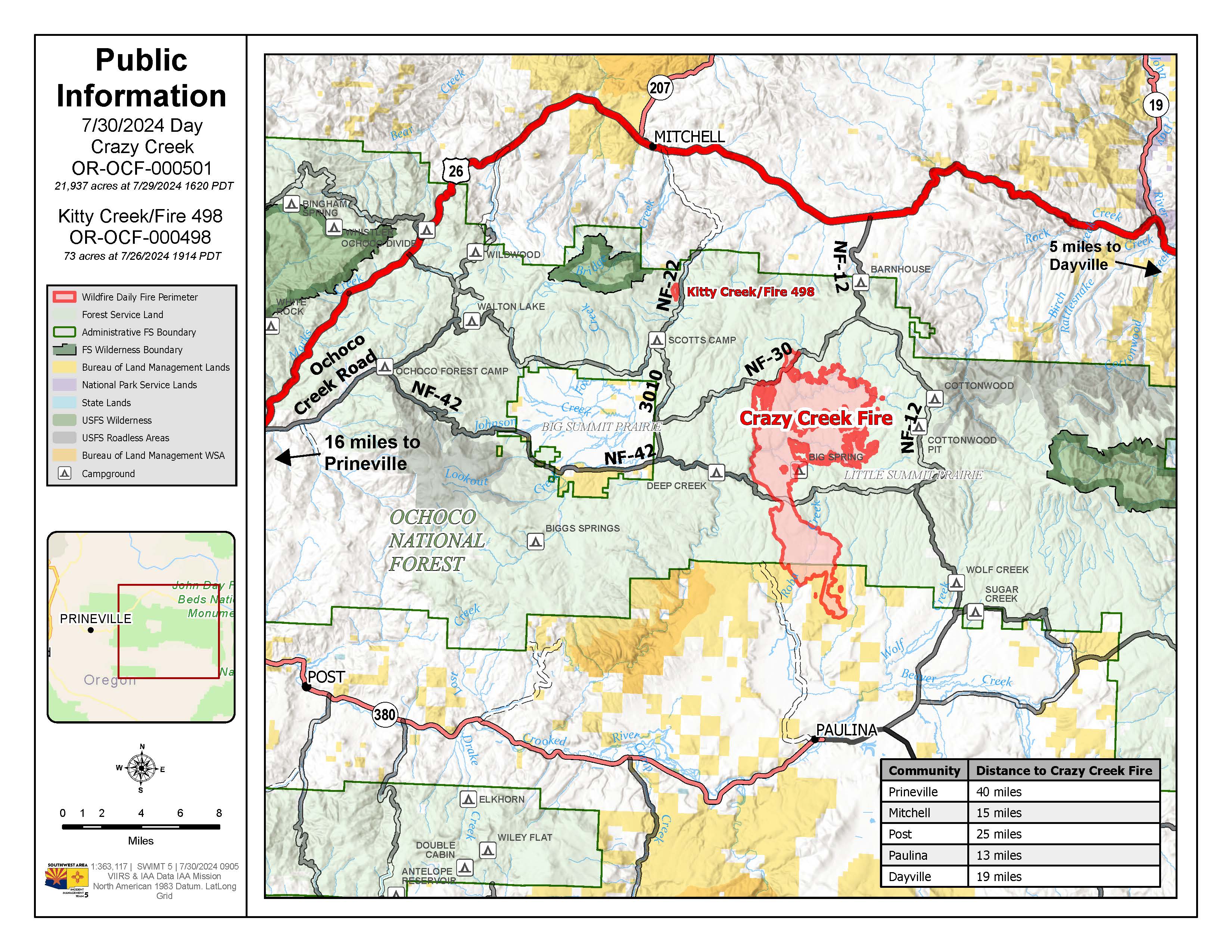
Crazy Creek Fire Daily Update for July 30 2024 07 30 2024
Related Incident: Crazy Creek
Publication Type: News
498/Kitty Creek containment increases as national resource limitations and extreme fire behavior continue to challenge firefighters on the Crazy Creek fire
Daily Update July 30, 2024
Fire Information Phone:541-208-1768 (8am-8pm)
Media Information Phone:541-208-1770 (8am-8pm)
Email: 2024.crazycreek@firenet.gov
Acres: Crazy Creek - 21,937; 498/Kitty Creek - 73 Start Date: July 22, 2024
Location: Crazy Creek:16 miles north of Paulina, OR Personnel: 302 total for both fires
498/Kitty Creek: 7 miles south of Mitchell, OR
Containment: Crazy Creek 0%; 498/Kitty Creek 86% Fuels: Timber and short grass
Resources: 8 crews | 21 engines | 5 bulldozers | 6 water tenders | 1 masticator | 6 skid steer
Highlights: As containment on the 498/Kitty Creek Fire increases significantly, dry, hot conditions continue to challenge firefighters on the Crazy Creek Fire. The national preparedness level (PL) and Northwest geographic area remain at a PL5 – the highest preparedness level on the National Interagency Coordination Center (NICC) rating system. In PL5, national resources are heavily committed, causing challenges for incident staffing and filling of necessary resource to respond to dynamic fire situations, such as those on the Crazy Creek fire.
Fire Activity: Fire reached Moccasin Ridge on the southern end of the Crazy Creek fire and extended 1/ 4 mile south of Forest Road 30, east of Happy Camp Creek. Creeping fire activity was observed in the mixed conifer and lodgepole pine stands on the northern/northeastern flanks of the Crazy Creek fire as well as through the heavy dead/downed fuels. Slow, steady fire progression occurred north along Double Corral Creek, reaching the dozer-constructed containment lines near Toggle Creek and continued northeasterly, progressing along Thornton and West Thornton creeks.
Tuesday, crews on the north end of the Crazy Creek fire will continue to prepare containment lines while monitoring fire progression and initiating firing operations as needed and when safe to do so. In the northeast, efforts will continue in Toggle Meadow, where hand crews and dozer operators will construct containment lines around the private land. Crews on the south end will continue constructing direct fire line on the southwest side of the fire and will continue indirect line construction on the southeast side of the fire. As the week progresses, the region will experience hot, dry conditions. With the incoming drying trend, primary fire growth is expected to occur in grass and timber with more extreme behavior, such as heavy torching, and increased fire spread due to short-range spotting in the mixed conifer forests of the fire area.
Crews on the 498/Kitty Creek fire will continue to patrol and monitor the fire perimeter to further increase containment.
Evacuations:LEVEL 3 evacuations in the Ochoco National Forest have been expanded to the eastern boundary of Big Summit Prairie and south of the Forest boundary. Crook County has extended LEVEL 3 (GO status) evacuations to the south. As of now, Hwy 380 is the dividing line between LEVEL 3 and LEVEL 2. Camp Creek Road east to SE Beaver Creek Road north to the Forest Boundary, and east to the county line has been increased to LEVEL 3. The areas south of Hwy 380 from Camp Creek Road east, east side of SE Beaver Creek Road to the Forest Boundary, and east to the county line is at LEVEL 2. Wheeler County evacuation zone WHH-019C-B is in GO status.
Weather: Cooler temperatures will continue on Tuesday, with a chance of showers in the morning and temperatures in the low-high 70s and wind gusts up to 20mph. A shift is expected mid-week, bringing with it warmer temperatures and dryer conditions across the 498/Kitty Creek and Crazy Creek fires.
Importance of Fire Prevention: All public lands in Central Oregon, to include the Ochoco National Forest are in Public Use (Fire) Restrictions. All open flames, including woodstoves and charcoal briquette fires are prohibited. In times of high fire danger, it is crucial for everyone to follow fire prevention measures to avoid additional strain on overburdened resources. The public's cooperation in adhering to fire bans and restrictions is vital to prevent new fires from starting and to help our firefighters focus on containing the existing fires. Learn more at https://www.fs.usda.gov/alerts/ochoco/alerts-notices/?aid=89068.
Smoke: Smoke from multiple fires in Central Oregon are impacting the region. Additional details are available via https://outlooks.wildlandfiresmoke.net/outlook/079f0f73.
Fire Restrictions and Closures: The Ochoco National Forest has implemented a forest closure for the Paulina Ranger District. More information can be found at fs.usda.gov/alerts/ochoco/alerts-notices/?aid=89203.
More Information:
InciWeb: https://inciweb.wildfire.gov/incident-information/orocf-crazy-creek
Facebook: https://www.facebook.com/SWIMT5
Central Oregon Wildfire Information: https://centraloregonfire.org/
Crook County Emergency Information Map: https://arcg.is/1ij0vb
Settings - change map background and toggle additional layers
Filter - control incident types displayed on map.
Zoom to your location
Reset map zoom and position
Could not determine your location.
Show Legend
 Wildfire
 Prescribed Fire
 Burned Area
Response
Burned Area
Response Other
Other
Lower Granite Fire
Unit Information
Incident Contacts
Pioneer Fire Update 07 30 2024
Related Incident:
Publication Type: News
Pioneer Fire Update for July 30, 2024
Incident Commander Lonnie Click
Complex Incident Management Team Northwest 3
(541) 861-5808, staffed 8 a.m. to 8 p.m. 2024.pioneer@firenet.gov
Quick Facts
Size: 33,277 acres*
Start Date: June 8, 2024
Location: 31 miles NW of Chelan, WA
Containment: 15%
Personnel: 732
Cause: Human-caused, under investigation
Resources Assigned: 11 crews, 4 helicopters, 29 engines, 27 water tenders, 17 heavy equipment
*No updated infrared mapping due to weather conditions.
There will be a community meeting in Manson Wednesday, 5:30 PM at the Manson High School. The meeting will be streamed live on the Pioneer Fire Information Facebook page. Please submit questions in advance to 2024.pioneer@firenet.gov or via Facebook Messenger.
CURRENT SITUATION: Yesterday cooler, damper, weather moderated fire activity. Firefighters are taking advantage of reduced fire activity to continue fireline preparations and other community protection measures along the lakeshore and in Stehekin. Helicopters dropped water to cool down scattered hot spots and slow fire spread around Hazard Creek. Crews continued to mop up and patrol around structures along the lakeshore in the Fourmile Creek. In Stehekin the Structure Protection Group continued improvement work by widening fireline. There was minimal fire activity in the Prince Creek area. South of the fire, road work to improve access for emergency response vehicles continued. There were no new fire starts, however crews remain ready to respond when needed.
TODAY’S ACTIVITIES: Aircraft will continue to work the ridgeline south of Hazard Creek, dropping water to limit fire spread. Firefighters will continue to protect structures along the lakeshore, mopping up and patrolling to ensure no heat remains where firing operations were conducted. In the Stehekin area, firefighters will continue to widen and improve the community protection lines. At the southwestern fire edge, firefighters will continue to monitor the Lone Fir drainage for any fire activity and will be available for initial attack in the event any new fires start. Crews will continue mastication and road work and other contingency line preparations along Cooper Ridge and other areas west of Manson.
WEATHER AND SMOKE: Today high temperatures will be in the mid-70s. Good RH (relative humidity) recovery overnight helped to increase the moisture in the small forest fuels (pine needles, leaves, and small twigs), which will limit potential for fire activity and spread, however larger fuels remain very dry. A warming and drying trend starts tomorrow with significantly warmer temperatures anticipated by the end of the week. See Current Smoke Outlook for North Central Washington (airfire.org) for information about smoke and air quality.
EVACUATIONS: Level 1, 2 and 3 evacuation levels remain in effect around the Pioneer Fire. Please visit https://t.ly/QoH9w for more information.
FOREST CLOSURE: Current closures for the North Cascades National Park: https://www.nps.gov/noca/index.htm
The Okanogan-Wenatchee National Forest has a closure order in place for much of the fire area: Okanogan-Wenatchee National Forest - Alerts & Closures (usda.gov). Campfires are prohibited. There is a Temporary Flight Restriction (TFR) in place over the fire: https://tfr.faa.gov/save_pages/detail_4_6779.html. Unauthorized drone activity is prohibited under the TFR.
Facebook: https://www.facebook.com/profile.php?id=61560760893080
Fire Information Line: 541-861-5808, 8 AM to 8 PM
Email: 2024.pioneer@firenet.gov
Badland Complex Daily Update 07 30 2024
Related Incident: Badland Complex 2024
Publication Type: News
Rocky Mountain Area Complex Incident Management Team Two
Jared Hohn, Incident Commander
Current Situation:
- The Badland Complex is 54,566 acres and 49% contained with 295 personnel assigned.
- Fire managers are using direct attack strategies, where firefighters are working very close to the active fire front on the Badland Complex.
- The Coyote Fire is now 22,184 acres and 75% contained. Yesterday, crews continued patrolling the fire’s southern end. Firefighters are being moved to assist with work on the Thompson Fire. The remaining resources will continue to monitor the fire near the Powder River.
- The Thompson Fire is now 31,556 acres and 20% contained. Yesterday, smoke jumpers began to work across the northeastern perimeter toward Manning Creek Road, as Gila Hotshots and hand crews continued progress north toward Big Lookout Mountain. Both teams are being assisted by skidgines and will continue working toward each other today to complete containment line. This line will help stop the fire’s progress to the east, toward the Snake River.
- More firefighting resources continue to arrive and are being deployed to assist on the Thompson Fire.
- The Powder Fire is 100% contained and is now in patrol status.
Weather & Smoke Information: Yesterday, a cold front moved into the area around 5 p.m., which brought wind gusts of up to 32 mph. The fire received less than a hundredth of an inch of rain. Tomorrow may bring occasional sprinkles, but very little lightning and no wetting rain. Northwest winds will be around 20 mph but will taper off in the afternoon. Temperatures will reach the upper 60s or lower 70s in the higher elevations and the 70s in the lower elevations.
An air quality advisory is in effect for Baker County due to heavy concentrations of wildfire smoke. For current Oregon air quality conditions, please visit https://oraqi.deq.state.or.us/home/map.
Evacuations: Baker County Sheriff’s Office has issued Level 1, 2, and 3 evacuation orders for multiple areas of the fire. Learn more at https://www.facebook.com/profile.php?id=100064434892363. Sign up for Baker County emergency alerts at https://public.alertsense.com/SignUp/publicUser.aspx?regionid=1357
Closures: Check for highway closures at https://www.tripcheck.com/DynamicReports/Report/RoadConditions. All BLM Vale District Recreation Sites along the Snake River between Oxbow and Huntington and on Lookout Mountain are closed. This includes Spring Recreation Site, Swedes Landing, and Bassar Diggins Campground.
Fire Restrictions: Fire Restrictions are in effect. Get details at https://www.blm.gov/sites/default/files/docs/2024-07/orwa-fpo-val-071024.pdf.
Temporary Flight Restrictions:A temporary flight restriction (TFR) is in effect over the fire area to provide a safe environment for firefighting aircraft operations. View a map of the TFR and details at https://tfr.faa.gov/save_pages/detail_4_7614.html. Fire aviation response is halted or delayed if an unauthorized aircraft enters the TFR. Temporary flight restrictions also apply to unmanned aircraft systems or drones. If you fly, we can’t! Learn more about how to use drones safely and responsibly at Home - Know Before You Fly.
Fire Info Phone: 541-362-1507 Hours: 7:00 a.m. to 7:00 p.m. Email: 2024.badlandcomplex@firenet.gov .
Facebook: @BadlandsComplexFires2024 Media Line: 541-249-5894
Inciweb: https://inciweb.wildfire.gov/incident-information/orvad-badland-complex-2024
Whisky Creek Fire Daily Update Actualizacin diaria del incendio Whisky Creek 07 30 2024
Related Incident: Whisky Creek Fire
Publication Type: News
Whisky Creek Fire Daily Update
July 30, 2024
Size / Tamaño: 891 acres
Start Date / Fecha de inicio: July 20, 2024 / 20 de julio de 2024
Cause / Causa: Human – Under Investigation / Humana, a ser determinada
Location / Ubicación: 6 miles SE of Cascade Locks, OR
Containment / Contención: 0%
Fuels / Combustibles: Scrub oak, timber, and grass / Arbustos de roble, restos de madera y césped
Total Personnel / Personal total: 284
Highlights / Aspectos destacados:
The Central Cascades Interagency Management Team assumed command of the Whisky Creek Fire on Monday July 29, 2024. Precipitation occurred over the fire area yesterday, moderating fire behavior. Cloud cover will diminish today over the fire as onshore flow continues, and warmer temperatures begin to develop over the region. Recent rain will continue to limit the growth of the fire and minimize smoke production.
El equipo de gestión interagencia de Central Cascades asumió el comando del incendio de Whisky Creek el día lunes 29 de julio de 2024. Ayer se produjeron precipitaciones sobre la zona del incendio, lo que moderó la intensidad del incendio. La cobertura de nubes disminuirá hoy sobre el incendio a medida que continúa el flujo de vientos terrestres, y comenzarán a desarrollarse temperaturas más cálidas sobre la región. La lluvia reciente seguirá limitando el crecimiento del incendio y reduciendo la producción de humo.
Operations / Operaciones:
Crews continue to prepare containment lines and clear roads and trails to the south along the Rainy-Wahtum Trail #409 from Rainy Lake to Wahtum Lake and continuing to the PCT approximately one mile to the 2017 Eagle Creek Fire burn area. Crews are clearing thick brush along roads with the assistance of masticators to create fire breaks. To the east of the fire, crews continue to strengthen contingency lines working towards the Hood River County Forestry Kingsley area.
Los equipos continúan preparando líneas de contención y limpiando vías y senderos al sur de Rainy-Wahtum Trail #409, desde Rainy Lake hasta Wahtum Lake y continuando hacia el PCT, aproximadamente una milla a la zona quemada de Eagle Creek en 2017. Los equipos se encuentran limpiando arbustos densos en carreteras con la ayuda de masticadores para crear cortafuegos. Hacia el este del incendio, los equipos siguen fortaleciendo las líneas de contención que funcionan hacia la zona de Hood River en el condado Forestry Kingsley.
Fire Behavior and Weather / Clima e intensidad del incendio:
Recent rain is expected to minimize fire activity. Warmer and drier temperatures are predicted to move into the region later this week and are expected to increase fire activity and smoke production.
Se espera que las recientes lluvias minimicen la intensidad del incendio, y que las temperaturas más cálidas y secas se desplacen hacia la región a final de esta semana y que provoquen un aumento en la intensidad del incendio y producción de humo.
Road and Trail Closures / Caminos y vías cerrados:
The Mt. Hood National Forest and the Columbia River Gorge National Scenic Area have expanded a joint emergency closure for the fire area to include the Pacific Crest Trail and areas south of I-84. Closure information can be found at: Whisky Creek Fire Closures in Mark O. Hatfield Wilderness. Hood River County has closures in effect for Kingsley Campground, Kingsley Road, Dead Point Road, and Green Point Road viewable on their website.
El Bosque Nacional Mt. Hood y el área escénica nacional del río Columbia emitieron un cierre conjunto de emergencia sobre la zona del incendio e incluyeron el Pacific Crest Trail y las áreas al sur de la I-84. Puede encontrar más información sobre los cierres en: Cierres por el incendio Whisky Creek en los espacios naturales de Mark O. Hatfield. Puede ver los cierres vigentes en el condado Hood River para el área de acampar Kingsley Campground, Kingsley Road, Dead Point Road y Green Point Road en sus páginas web.
Total Fire Resources Assigned / Total de recursos asignados al incendio:
- Approx. 284 personnel/personas, 6 hand crews/equipos de obreros, 4 water tenders/camiones de bomberos, 3 dozers/buldóceres, 5 masticators/tractores, and/y 3 helicopters/helicópteros.
Contact Information / Información de contacto:
Email / Correo electrónico: 2024.whiskycreek@firenet.gov, Phone / teléfono: 514-208-1743 8 A.M - 8 P.M
Pyramid and Slate Fires Daily Update 07 30 2024
Related Incident: Pyramid and Slate Fires
Publication Type: News
SLATE FIRE
SLATE FIRE PUBLIC MEETING TONIGHT: A public meeting about the Slate Fire will be held on Tuesday, July 30, at 6 p.m. The meeting will take place at Detroit City Hall, 345 Santiam Ave. W. If you can't attend in person, you can watch the meeting live on the Willamette National Forest YouTube Channel at www.youtube.com/@WillametteFireInfo. If you have questions you'd like answered at the meeting, please email them to 2024.Pyramid@firenet.gov.
5 miles SW of Detroit, OR, 91 Acres, 27 Percent Contained, Total Personnel, 50, Under Investigation
Fire managers continue to emphasize the need to combat the Slate Fire aggressively despite milder weather. Control lines have been constructed and reinforced with hose and pumps. Firefighters are now tasked with the laborious process of mop-up. Mop-up refers to the challenging physical work of putting out burning material within the control line, removing fire-damaged trees, and cooling ash pits. Firefighters will be engaging in mop-up operations for the next few days to ensure that the control lines are secure.
PYRAMID FIRE
PYRAMID FIRE PUBLIC MEETING: A public meeting about the Pyramid Fire will be held on Wednesday, July 31, at 6 p.m. at Sweet Home Fire District, 1099 Long Street, Sweet Home. If you can't attend in person, you can watch the meeting live on the Willamette National Forest YouTube Channel at www.youtube.com/@WillametteFireInfo. If you have questions you'd like answered at the meeting, please email them to 2024.Pyramid@firenet.gov.
East of Middle Santiam Wilderness, 1,156 Acres, 11 Percent Contained, Total Personnel, 397, Lightning Caused
Yesterday, cooler weather reduced the fire activity and enabled firefighters to make significant progress in improving control lines. Heavy equipment is still being used, along with crews, to enhance the existing control lines on the fire perimeter. Today, crews are focused on constructing direct line on the east flank, at the fire’s edge, towards the 580 Road. Firefighters are also keeping a close watch on the area, extinguishing any hot spots within the fire perimeter.
WEATHER AND SMOKE IMPACTS: Today will be relatively cool with increased humidity. The rest of the week will be warm and dry with a major heat wave expected this weekend. Smoke and air quality conditions are available on: AirNow.gov
EVACUATIONS: On July 17th, the Linn County Sheriff’s Office, in coordination with the Forest, issued a Level 3: Go Now Evacuation Alert for the closure area affected. Please refer to the Linn County Fire Map https://tinyurl.com/LinnCoFireMap for full details of the issued evacuation area (which will appear in red).
AREA CLOSURES: Due to active fires, road, recreation sites, and trail (including the PCT) closures are in effect in the Willamette National Forest. Specific information is posted at https://www.fs.usda.gov/detail/willamette/alerts-notices/?cid=fseprd552029.
FIRE RESTRICTIONS: Fire restrictions are in effect for Willamette National Forest, including the Three Sisters, Mt. Jefferson, Mt. Washington, Waldo Lake, and Diamond Peak Wilderness areas. Read the complete restrictions at: https://www.fs.usda.gov/alerts/willamette/alerts-notices/?aid=81487.