
Apache Fire Daily Update 07 30 2024
Related Incident: Apache Fire
Publication Type: News
![]()
![]() Apache Fire Incident Update July 30, 2024
Apache Fire Incident Update July 30, 2024
Mount Pinos Ranger District: (661) 245-3731
This will be the final Apache Fire Update
Apache Fire Start: Tuesday, July 23, 2024, at 6:31 p.m.
Cause: Under investigation
Location: Maricopa Highway and Apache Canyon Road, Cuyama Valley, Ventura County
Size at time of update: 1,538 acres
Containment: 80%
Personnel: 209
Incident Details: https://inciweb.wildfire.gov/incident-information/calpf-apache-fire
Resources:
Hand Crews: 3 Engines: 10 Water Tenders: 3 Dozers: 1
Crews on the Apache fire are continuing their work to complete the containment lines today. Hoselines, pumps and other equipment used in the suppression effort are being removed and rehabilitated for the next assignment. It is estimated that suppression repair work on contingency lines will be complete in 2-3 days.
California Interagency Complex Incident Management Team 2 will be transitioning command to a Los Padres National Forest type four incident management team at 6 p.m. tonight.
The burn area is adjacent to Maricopa Highway (CA-33). The highway is open. Motorists are encouraged to be alert for firefighters and equipment in the area. Please check Caltrans road conditions prior to driving through the area.
Forest Closure: A forest closure is in effect in the Apache Fire area, Forest Order 05-07-57-24-18.. Please check Los Padres National Forest - Home (usda.gov) for additional information prior to visiting the area.
Forecast for Tuesday: Highs in the fire area will range from the mid 80s to low 90s. Relative humidity will remain low at 17-25%. Winds will be out of the northwest 5-10 mph and will transition to northeast in the afternoon. A light chance of precipitation may be on the horizon starting the next weekend.
Evacuation Areas: All evacuation warnings and evacuation orders have been lifted.
Los Padres National Forest Facebook Ventura County Fire Department Facebook Ventura County Fire X
Miller Peak Fire Daily Update July 30 2024 07 30 2024
Related Incident:
Publication Type: News
KEY MESSAGE
Northern Rockies Team 9 assumed control of the fire at 0600 this morning. The fire remains at 65% containment as crews continue to mop up and strengthen containment lines around the perimeter of the fire. Today a low-pressure system will be over the area bringing cooler temperatures with widespread rain across the fire area.
Current Status
The incoming Incident Management Team has taken over the fire and continues to diligently work to secure the fire. The team continues to adjust working tactics to the scale of complexity that remains on the fire. Crews continue to secure and improve containment lines around the fire. The eastern and northern flanks continue to be areas of concern due to pockets of unburned fuel near the fires edge.
WEATHER AND FIRE BEHAVIOR
A cold front moved through last night bringing precipitation to the area. Today a low pressure system will be over the area bringing significantly cooler temperatures with widespread rain showers. The fire has over a 60% chance of receiving at least a tenth of an inch of rainfall by this afternoon. A strong ridge of high pressure is still expected to build back over the western United States by the end of the week into the weekend.
CLOSURES
Lower Miller Creek Road is closed from debris due to storm damage. The temporary flight restriction has reduced in size. An area and road closure around the fire is in effect due to hazardous conditions resulting from fire activity and for personal safety. Stage II fire restrictions are in effect in the area. Specific closure information and maps are posted on InciWeb at https://inciweb.wildfire.gov/incident-information/mtlnf-miller-peak-fire and https://www.fs.usda.gov/alerts/lolo/alerts-notices as they are implemented.
Limepoint and Cliff Mountain Fire Daily Update Tuesday July 30 2024 07 30 2024
Related Incident: Limepoint Fire
Publication Type: News
Limepoint and Cliff Mountain Fires
Fire Information 208-992-3032
2024.limepoint@firenet.gov
Limepoint: https://inciweb.wildfire.gov/incident-information/idpaf-limepoint-fire
Cliff Mountain: https://inciweb.wildfire.gov/incident-information/idpaf-cliff-mountain
https://www.facebook.com/payettenationalforest/
Tuesday, July 30, 2024
Today the Payette National Forest issued a Forest Closure Order to protect public safety during the Limepoint and Cliff Mountain wildfires (see below). This morning the Southern Area Red Complex Incident Management Team joined with the Payette National Forest, Wallowa-Whitman National Forest, Bureau of Land Management and Idaho Department of Lands in command of the Limepoint and Cliff Mountain Fires in the Hells Canyon area, located on the Payette National Forest in west-central Idaho, east of the Snake River bordering Oregon.
Note: A community meeting about the Limepoint/Oxbow and Cliff Mountain Fires will be held 7:00 p.m. tomorrow evening, Wednesday, July 31st at the Adams County Recreation Center at 104 S. Galena Street, Council, Idaho 83612. An operational briefing about the fires at the meeting will be presented via Facebook Live on the Payette National Forest’s Facebook page (https://www.facebook.com/payettenationalforest/).
Limepoint Fire
The Limepoint Fire is north of Oxbow Dam in Adams County Idaho and was started by lightning on July 24th, burning in tall grass and brush. The southern part of the fire was once a smaller, separate fire named the Oxbow Fire, but both fires burned together and are now collectively known as the Limepoint fire. It is now 17,908 acres with no containment. The area of the fire in the Indian Creek drainage threatens the communities of Cuprum and Bear, both of which remain evacuated per Adams County Sheriff’s Office.
Yesterday, the fire was active on all sides. Firefighters concentrated their efforts on the north flank of the fire, where the fire hooked around and pushed south toward Cuprum. They successfully kept the fire west and north of Cuprum with the help of helicopter drops. The fire continued to flank northward in this area. On the south side of Indian Creek fire crossed the ridge and spotted in the Bull Gulch area west of Bear across Forest Service road 071 (Flat Creek Road/Barbour Flat Road). The fire grew to three acres with one to six-inch flame lengths before firefighters arrived to contain it. Last night firefighters protected homes from fire backing down to the Snake River with small, defensible tactical firing operations.
Two hand crews, 12 engines, three bulldozers and two large helicopters are working on the Limepoint Fire. Full suppression of it is challenged by lack of firefighting personnel and equipment, including aircraft, due to an active western fire season and steep, rugged terrain and dry, burnable vegetation. More people and equipment have been ordered, but due to competition for resources with other fires, it is unknown when they will arrive. In the meantime, firefighters are focusing efforts on protecting and preparing threatened structures in Oxbow, Cuprum, Bear and Hells Canyon Recreation Area until resources arrive. A primary objective is to keep the fire west of Indian Creek. Light rain over the fire last night and lower temperatures today will help slow growth of the fire in grassy areas and other light fuels. “Take advantage of the moisture to anchor, flank and pinch this fire,” said Red Team Operations Chief Josh Graham. Firefighters will continue to scout areas to identify areas from which they can hold the fire directly at its edge or from a defensible anchor point once more people and equipment arrive. Firefighters will work throughout the night to ensure point protection of structures at risk.
Cliff Mountain Fire
The Cliff Mountain Fire started on July 25th in Hells Canyon National Recreation Area in wilderness just below Hells Canyon Dam 25 miles east of Joseph, Oregon in Adams and Idaho Counties, Idaho. It is 1,101 acres with no containment, burning mostly in wilderness, with growth slowed in some areas due to steep rocks. Firefighters are monitoring the fire, but no ground personnel or equipment have been assigned to it.
WEATHER AND FIRE BEHAVIOR
Showers will continue this morning from a cold front that moved through last night. Air operations are likely to be limited due to an inversion during morning hours and fire-wide smoke produced in the afternoon. Instability aloft poses a slight chance of thunderstorms this afternoon. High pressure will bring hotter and drier weather starting Wednesday. The chance of rain is 60 percent today, with minimum relative humidity 39 to 44 percent. High temperatures are forecasted as 74 to 79 with north to northeast winds around 8 mph.
Increased humidity and lower temperatures from the cold front may moderate fire activity in lighter fuels such as grassy areas. A weather station on the Limepoint Fire registered 0.27 inches of rain. Where stringers of brush and timber align with wind, upslope fire spread and some spotting could occur. Backing fire may ignite light, flashy fuels laterally and allow for rapid uphill runs with spotting above and to the side when winds are across slope. Rolling material can cause new spots low on slopes that remain hidden by smoke long after they are established. If thunderstorms form in the afternoon, rapid spread may occur with direction of spread changing quickly as cells pass over with outflow winds.
Air quality information is available at www.airnow.gov and www.wildlandfiresmoke.net.
Evacuations:
The communities of Cuprum and Bear have been evacuated per Adams County Sheriff’s Department and remain under a “GO” evacuation.
Closures and Restrictions
The Payette National Forest issued a Forest Closure to protect public safety during the Oxbow, Limepoint and Cliff Mountain wildfires. The closure includes, but not limited to the following recreation areas: Black Lake, Sheep Rock, Kinney Point and Horse Mountain Lookout. Big Bar is open, but all access roads to it on the Payette National Forest are closed. Huckleberry Campground is also closed. For more information and a map, see https://inciweb.wildfire.gov/incident-publication/idpaf-limepoint-fire/limepoint-fire-area-closure-order-07-29-2024.
The following roads are closed: Kleinschmidt Grade (Forest Road 050), Forest Road 454, which runs along the river, is closed except for permitee use, and all county-managed roads into Cuprum.
A temporary flight restriction remains in place.
Stage 1 Fire Restrictions are in effect for the Payette National Forest. The following are prohibited:
- Building, maintaining, attending or using a fire, campfire or stove fire except within a designated recreation site, or on your own land, and only within a permanent landowner-provided structure.
- Smoking, except within an enclosed vehicle, building, or designated recreation site, or while stopped in an area at least three feet in diameter that is barren or cleared of all flammable materials.
Speirs Fire Daily Fact Sheet 07 30 2024
Related Incident: Speirs Fire
Publication Type: News
Current Status
• The Speirs Fire is currently at 715 acres and is 97 percent contained.
• The Speirs Fire was caused by lightening.
• There are currently 105 people working on the Speirs Fire.
Closures
• The Firefighter Memorial and Green Dale Group campgrounds are open.
• The following roads and trails are still closed to public access.
o Forest Service Road (FSR) 610, FSR 689, FSR049 (Greens Draw Road), Lowline trail FST103 its junction with the Pipe Creek Trail, FST 003. Forest Service Trail 003 from the beginning at the junction with FST 103 to the junction of Forest Service Trail 004 and Forest Service Trail 004 to Greens Draw Road 049.
o For more information on existing closures, please visit the Ashley National Forest website at https://www.fs.usda.gov/alerts/ashley/alerts-notices
Updates
• The Ashley National Forest thanks Great Basin Team 3 for their hard work over the past two weeks. Command has been transferred to Incident Commanders Riley Bergseng & Ryan Lafontaine with Northern Utah Type 3 Team.
Silver King Fire Daily Update July 30 2024 07 30 2024
Related Incident: Silver King Fire
Publication Type: News
Public Information Phone: (435) 310-5450 Email: 2024.silverking@firenet.gov
Agency: Fishlake National Forest – Beaver Ranger District
Location: Approximately three miles west of Marysvale, Utah
Start Date: July 05, 2024
Cause: Lightning
Acres: 18,222
Containment/Completion: 89%
Personnel: 157
**RED FLAG WARNING IN EFFECT UNTIL 10:00 P.M. TUESDAY**
The National Weather Service has extended the Red Flag Warning for the Silver King Fire and surrounding areas until 10:00 p.m., Tuesday, July 30, 2024. Temperatures in the mid-80s, humidity as low as 6%, and winds over 25 mph may cause existing fires or new fires to spread rapidly.
During Red Flag conditions residents should avoid using machinery that can create sparks and ensure that trailer chains do not drag. Do not drop cigarettes or matches on the ground. Avoid recreational target shooting in dry grass. Follow Stage 1 Fire Restrictions that prohibit open fires of any kind except within established public facilities in improved campgrounds and picnic areas. Give firefighters room to work and abide by the Silver King Fire Forest Closure Order (see closure details at: https://www.fs.usda.gov/alerts/fishlake/alerts-notices).
On the north side of the fire, crews are patrolling and extinguishing hotspots. On the south side, firefighters continue to hold and improve on their confinement strategy. On the east side, the heavy equipment has completed dozer line repair and will continue that work on the north side of the fire.
The dozer line repair is part of fire suppression damage repair, one of the first steps in rehabilitating and restoring a burned landscape. Immediately following suppression damage repair is emergency stabilization by a Burned Area Emergency Response (BAER) team, and one began work on the Silver King Fire last week. BAER team efforts typically include seeding, mulching, and managing water runoff. In some cases, Burned Area Rehabilitation (BAR) may provide a “bridge” to long-term recovery. BAR utilizes non-emergency actions, for up to five years post-fire, to improve fire-damaged lands that are unlikely to recover naturally. Once the land has been stabilized long-term recovery and restoration work, including hazard tree removal, reforestation, and infrastructure repair, can begin.
Settings - change map background and toggle additional layers
Filter - control incident types displayed on map.
Zoom to your location
Reset map zoom and position
Could not determine your location.
Show Legend
 Wildfire
 Prescribed Fire
 Burned Area
Response
Burned Area
Response Other
Other
Black Mountain
Unit Information
Incident Contacts
Battle Mountain Complex 07 30 2024
Related Incident: Battle Mountain Complex
Publication Type: News
Rain showers and milder weather provide brief respite for fighters on the Battle Mountain Complex
UKIAH, Ore. – Rain showers across northeastern Oregon brought cooler temperatures and higher relative humidity to the Battle Mountain Complex, which helped firefighters push forward on progress. While rainfall totals only reached 1/100 of an inch, the cloud cover and moisture created a natural decrease in fire behavior, and resources were able to take advantage of a calmer day on the line.
On Zone I, firefighters with Oregon Department of Forestry Team 1 and Oregon State Fire Marshal taskforces focused on the Cupper Creek area, northwest of Monument. Fire was particularly active in the drainage north of Highway 402 over the past couple of days, which prompted an eight-mile closure of the highway west of Monument last night. Cupper Creek Road also remains closed to the public. Structural firefighters will remain engaged in this area tonight, conducting mop-up and point-protection operations around structures that were threatened by wildfire. Conditions today and tonight have significantly reduced this risk, however more work is necessary before this area will be considered contained. Wildland firefighters and other resources will remain engaged on the fire tonight, building new containment line and taking advantage of the conditions to mop up where possible.
Across the rest of Zone I, containment lines on the majority of the zone are continuing to hold, and firefighters spent the cooler day strengthening lines and mopping up, creating a larger barrier between the interior of the fire and its perimeter. Tonight, that work will continue across Zone I. These efforts contribute to overall containment on the incident, and as progress continues, that number will increase.
In Zone II, crews also took advantage of the increased humidity and reduced fire activity, allowing firefighters to gain direct access to the fire line and build upon mop up progress. This is important as an increase in hot critical weather is expected later this week.
On the southeast edge of the fire, lines held throughout the day after crews worked to tighten and connect lines. Along Hwy 395, firefighters made progress by locating and mopping up burning material near control lines, up to 100 feet inside the perimeter.
Structural taskforces continue their focus on creating defensible space around homes and other structures in the Potamus drainage system that will increase the chances of survivability.
Firefighters continue to patrol and mop up on the North Fork Owens Fire, which remains at 90% containment (the complex stands at 10% containment).
Evacuations: Level 1 (Be Ready), Level 2 (Be Set) and Level 3 (Go Now) evacuations are in effect. For updated information, visit:
- For Umatilla County, follow www.facebook.com/UmatillaCountySheriff or sign up for Umatilla County Emergency Alert System at https://member.everbridge.net/index/2590041373147145.
- For Grant County, visit the RAPTOR arcgis site or sign up for alerts at: https://member.everbridge.net/index/825462649520134.
- For Morrow County, visit https://experience.arcgis.com/experience/de78333b0d2544f7a320142174aa20ae
Public Land Closures:
The Bureau of Land Management has closed public lands along the John Day River from Kimberly to Dale, and from Kimberly to Service Creek. More information here: https://www.blm.gov/programs/public-safety-and-fire/fire-and-aviation/regional-info/oregon-washington/fire-restrictions.
The Umatilla National Forest has implemented a closure for public lands within the Heppner Ranger District and the North Fork John Day Ranger District. More information at: https://www.fs.usda.gov/detail/umatilla/news-events/?cid=FSEPRD1194462 and https://www.fs.usda.gov/detail/umatilla/alerts-notices/?cid=stelprdb5286768.
FIRE AT A GLANCE
Total Estimated Complex Size: 178,171 acres
Monkey Creek Fire: 173,687
North Fork Owens: 4,484 acres
Total Containment 10%
Cause: Under Investigation
Estimated Cost: $30,544,160
All Resources
Hand Crews: 65
Engines: 88
Water Tenders: 37
Dozers: 29
Helicopters: 4
Total Personnel: 1,990
Courtrock Evening News Release 07 30 2024
Related Incident: Courtrock Fire
Publication Type: News
This will be the final evening release unless conditions significantly change
Containment increases on Courtrock Fire, progress made in cooler, damp conditions
MONUMENT, Ore. – Firefighters on the Courtrock Fire took advantage of the cool temperatures and scattered showers today, pushing forward on strengthening existing line around the majority of the incident and constructing new line on the southeast portion. Due to this work, containment has increased to 31%, up from 24% this morning. The rain also helped to clear out smoke, which allowed aircraft to fly once again today.
Oregon State Fire Marshal task forces remain engaged in the Fox Valley area, where engines have been positioned to protect homes that have been impacted by the fire or are located near it, particularly along the 3950 road. Task forces will remain in the area overnight, continuing this work.
On the north, east and west lines, firefighters have been mopping up, which is further securing the line and creating a greater distance between the perimeter and the interior of the fire. Conditions overnight are expected to remain cool with high relative humidity, allowing for this work to continue.
More showers are in the forecast tonight, with a very slight potential for thunderstorms. Temperatures are expected to slowly heat up the remainder of the week. Firefighters will be taking advantage of the cooler conditions in the next day to continue to make progress on connecting and strengthening line before Thursday, when temperatures will be the high 90s once again, drying out vegetation and naturally increasing fire activity.
Due to fire activity in the area, the U.S. Forest Service has issued closures for the Malheur. Up to date information on Malheur National Forest closures can be found here: https://www.fs.usda.gov/news/malheur/news-events
Information for Zone I of the Battle Mountain Complex, including the western portion of the Monkey Creek Fire (formerly Boneyard Fire) can now be found at: www.facebook.com/battlemountaincomplex2024
Evacuations: Level 1 (Get Ready), Level 2 (Be Set) and Level 3 (Go Now) evacuations are in effect. For updated evacuation information:
- Grant County Emergency Management Office’s Facebook page, or sign up for the Grant County Emergency Alert System at https://member.everbridge.net/825462649520134/login. Morrow County Evacuation information can be found at https://experience.arcgis.com/experience/de78333b0d2544f7a320142174aa20ae
Shelters: An evacuation center has been set up at Grant Union High School (911 S Canyon Blvd., John Day, OR 97845).
Clean air and cooling centers are located in the following locations in Grant County:
- Grant County Library- cooling & clean air, Monday – Thursday 11 a.m. - 5:30 p.m.
- John Day Senior Center- cooling & clean air, Monday & Thursday 10 a.m. – 5 p.m., Tuesday 12 – 4 p.m.
- Prairie City Public Works - clean air center, Monday - Friday 12 – 7 p.m.
- Dayville Community Hall- cooling & clean air, 24/7
Limepoint Fire Evening Update July 29 2024 07 30 2024
Related Incident: Limepoint Fire
Publication Type: News
Limepoint Fire - Due to fire activity, the Bear area evacuation level has been elevated to Level 3 – GO. Cuprum remains in a Level 3 – GO evacuation status. *The Oxbow Fire has merged with the Limepoint fire at mid-slope in Indian Creek.
The Limepoint fire was last reported at 4,500 acres – updated acreage will be provided from an IR flight over the fire area tonight. No structures have been lost, but many remain threatened throughout the Cuprum area and to the southeast in the Bear area.
Active fire behavior took place today and pushed the fire across the ridge in two places.
The fire crossed the ridge on the south side of Indian Creek and established itself in Bull Gulch, then produced spot fires across Forest Service Road 071 (Flat Creek/Barbour Flat Road). Firefighters are on site of the spot fires and addressing the situation.
To the north of Lynes Saddle the fire came over the ridge and established itself north of Cuprum. This fire activity triggered a management action point to conduct a burnout operation around the community of Cuprum. The burnout was successfully completed, and no structures have been lost in the area. The most active part of the fire north Cuprum is in the Dean, Salt and Elk creek drainages.
As the Oxbow Fire has merged with the Limepoint Fire, the Oxbow Fire will no longer be reported on separately, rather information will be shared here. Fire activity around the Oxbow dam continues to push to the south in the area of the dam. Fire managers are working closely with Idaho Power officials regarding the values at risk in the area and taking measures to project these values.
The focus of efforts remains on providing structure protection to Cuprum and to structure north of Cuprum and south towards Bear, and to protect values at risk in the Oxbow Dam area. With heavy smoke over the fire area today. Aerial resources were limited due to visibility.
The Southern Area Red Team will assume command of the Hells Canyon's Fire in the morning to include the Cliff Mountain Fire burning along the Snake River in the Hells Canyon National Recreation Area.
Inciweb Link: https://inciweb.wildfire.gov/inciden.../idpaf-limepoint-fire
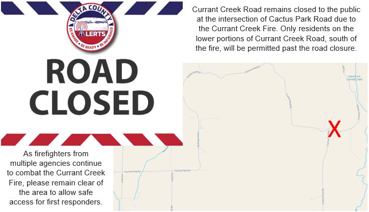
Currant Creek Fire Road Closure 07 30 2024
Related Incident: Currant Creek Fire
Publication Type: Announcement
Currant Creek Fire - Road Closure
Cedaredge area residents, please note that Currant Creek Road remains closed to the public at the intersection with Cactus Park Road due to the Currant Creek Fire.
Only residents on the lower portions of Currant Creek Road, south of the fire, will be permitted past the road closure. Fire crews have a list of addresses and homeowners and will verify home ownership before you are allowed into the area. We ask that non-residents who are just wanting to look at the fire please avoid the area. We need to maintain a clear access road for firefighter safety.
Thank you.