
Daily Operational Video for the Sand Stone Deer and Davenport Fires 07 30 2024
Related Incident: Sand Stone
Publication Type: Announcement
Daily Operational Video Update for the Sand Stone, Deer, and Davenport Fires
Facebook link: https://fb.watch/tEPHYa23UT/
Oakridge Lightning Fires 2024 Daily Update Tuesday 07 30 2024
Related Incident: Willamette Complex Fires - South
Publication Type: News
Fire Update – Oakridge Lightning Fires
Chalk, Coffeepot, McKinley, Moss Mountain, Tire Mountain, 208, and 217 Fires
Tuesday, July 30, 2024 – 9:00 a.m.
Rocky Mountain Complex Incident Management Team 1
Dan Dallas, Incident Commander
Information Phone: (541) 208-1742
Email:2024.mossmountain@firenet.gov
Information Staffing Hours: 8 a.m. to 8 p.m.
Special Note: A community meeting will be held Wednesday, July 31, at 6:00 p.m. in the auditorium of the Oakridge High School, 47997 W 1st St. Oakridge, OR. Fire managers and local officials will provide the latest updates on fire activity and suppression efforts. Parking at the high school is limited; please plan accordingly.
Current Situation: Smoke and clouds are expected to lift around noon today, allowing sun to align with receptive fuels and increase fire activity. There is no increase in acreage numbers across the Oakridge Lightning Fires today, as infrared flights were not able to collect this data last night. New acreages are expected tomorrow, showing low to moderate growth on some fires, while the 217 Fire is now at 100% contained. An increase in firing operations is expected this week, allowing fire management to secure lines and provide additional strategic, long-term options in managing the Oakridge Lightning Fires.
The total acreage of the seven fires is 6,824 acres with 641 personnel assigned.
Information for each of the seven Oakridge Lightning Fires is provided below. Firefighting activities and suppression actions are described in detail for each double-lettered division on each fire.
Chalk Fire (3,616 acres, 7% contained)
Division AA: Fire line has been prepared. Firefighters will continue to reinforce line and lay hose as plans move forward for a firing operation to occur within the next few days, as favorable conditions allow.
Division KK: Firing operations from the last few days have been completed. Crews will be mopping up edges where necessary so they can anchor here as firing operations increase on other areas of the Chalk Fire.
Division TT: Heavy equipment and hand crews are working along the 1912 Road and moving north toward the 646 Road as they continue to prepare this area. Felling crews are in place and working to remove snags.
Coffeepot Fire (2,761 acres, 0% contained) and Moss Mountain Fire (224 acres, 0% contained)
Division PP: Crews have secured line where the fire has reached the 21 Road. Additional spot fires were discovered and addressed yesterday. A newly formed Firing Group will supplement efforts on multiple divisions across the Coffeepot Fire and will be focused on supporting efforts in Division PP today.
Division RR: Line is completed, low intensity firing operations are occurring in the Stone Mountain area to strengthen fire line. Additional low intensity firing operations are planned for this evening and tomorrow.
Division SS: Work continues south of Moss Mountain. As more equipment arrives, they will work to tie in with Division WW to the east and Division PP to the west.
Division WW: Line is prepared out to 23 Road where firefighters’ work on building line continues toward the SS division break.
Division YY: Fire managers continue scouting south of the Coffeepot and Moss Mountain areas between the current proposed containment lines and private lands. They are looking for strategic opportunities and possible additional contingency line in the event they are needed.
Tire Mountain Fire (20 acres) – Division TT: The Tire Mountain Fire remains under mop up and patrol status. The fire has not grown in several days.
McKinley Fire (24 acres) – Division AA: Containment lines are in place and expected to hold, however, spot fires may occur due to the significant amount of dead and down fuel. Crews will continue to patrol and mop up the perimeter while remaining vigilant.
208 Fire (141 acres, 0% contained) – Branch XII: Fire is holding. There has been no recent growth in this area.
217 Fire (38 acres, 100% contained) – Branch XII: The 217 Fire is contained. Crews will continue to patrol.
Weather and Fire Behavior:
Clouds are expected to clear out by noon today, allowing the sun to align with aspects across most of the Oakridge Lightning Fires. Fire activity is expected to increase today, though northwest winds will remain light. Temperatures will noticeably increase later this week, starting on Thursday.
Extremely dry and dead fuels will contribute to moderate fire activity today especially where sun is able to reach the forest. Spot fires from burning lichen and large snags rolling down steep terrain remain a concern for firefighters and have contributed to previous spot fires.
Evacuations:
For evacuation information please visit: https://www.LaneCountyOR.gov/2024wildfires
To sign up for evacuation alerts please visit: https://www.LaneAlerts.org
Closures and Fire Restrictions:
Area, road, trail, and recreation site closures are in place on the Willamette National Forest in the vicinity of many active fires. Temporary road barricades are in place to restrict traffic across the fire areas.
For specific closure information follow this link:
https://www.fs.usda.gov/detail/willamette/alerts-notices/?cid=fseprd552029
Fire restrictions on the Willamette National Forest may be found at this link: https://www.fs.usda.gov/alerts/willamette/alerts-notices/?aid=81487
Temporary Flight Restrictions (TFR) are in place over the Chalk and Moss Fires.
Wildfires are a no-fly zone for unauthorized aircraft, including drones. If you fly, we can’t. For more information, visit http://knowbeforeyoufly.org.
For More Information:
Phone: (541) 208-1742
Email: 2024.mossmountain@firenet.gov
InciWeb: https://inciweb.wildfire.gov/incident-information/orwif-oakridge-lightning-fires-2024
Facebook: https://www.facebook.com/OakridgeLightningFires2024/
Total Fire Personnel: 641
Fire Cause: Lightning
Location: North & South of Oakridge, OR
Ore Fire Update 07 30 2024
Related Incident: Ore Fire
Publication Type: News
Ore Fire Update
Tuesday, July 30, 2024 – 9:30 a.m.
Size: 1452 acres | Reported Date: July 16, 2024 | Cause: Under Investigation | Containment: 29%
Total Assigned Personnel: 310 | 6 engines | 5 hand crews | 3 dozers | 19 water tenders | 8 masticators | 4 feller bunchers
(Blue River, Ore.) – Fire suppression efforts continue on the Ore Fire, which is burning 7 miles northeast of Blue River, Oregon. Challenges include steep and rugged terrain, rolling rocks and debris, and fire-weakened trees. Firefighter and public safety remain the number one priority on the incident. Fire managers are focusing on activities with a high probability of success while minimizing risk to firefighters and protecting values such as communities, infrastructure and forest, recreation and cultural resources. Crews' arduous work over the past two weeks has resulted in containment lines that are protecting these values to the south. The demanding and prolonged nature of wildland firefighting can significantly impact the overall well-being of incident response personnel. Small actions such as the public’s appreciation signs and visits from therapy dogs have made a big difference to morale.
Yesterday, fire activity was moderated by scattered showers. Crews removed hazardous trees from the FS 1509 Road using explosives rather than felling these large diameter fire-damaged trees, minimizing exposure to ground personnel. Elsewhere to the north, heavy equipment operators graded, cleared and widened roads to be utilized as containment lines.
Today, efforts are ongoing to patrol and monitor the secured fire perimeters. Plumbing with sprinklers and hose lays will be reallocated from the contained areas to the areas where the fire's edge is progressing down the hillside along the FS 1509 Road. Crews will begin connecting the FS 1509 Road north to the FS 842 Road utilizing a mix of hand lines and dozer lines to cut out a dangerous section of steep, tight turns.
Mental and emotional fatigue can impair firefighter’s ability to work effectively, and even small errors can have catastrophic consequences in wildland firefighting. Wildland firefighters are facing longer and more destructive fire seasons. Agencies are working to provide mental health resources, promote work-life balance, and provide well-being support while on an incident. In response, a special guest visited the incident to combat fatigue and boost morale yesterday -- Apollo the Therapy Dog (contracted through Global Medical Response in partnership with AT&T FirstNet).
Weather: Cloudy and cool conditions with scattered showers are forecast through noon today before drier air moves over the fire. Moderated fire weather will continue into the afternoon. Hot and dry conditions return tomorrow and continue into the weekend, resulting in increased fire danger.
Safety: Fire restrictions are in effect. For additional information, visit https://www.fs.usda.gov/main/willamette/fire. A Temporary Flight Restriction (TFR) is in place over the fire area. Unstaffed Aerial Systems (UAS or drones) are prohibited within the TFR. Find out more at: If You Fly, We Can't | US Forest Service (usda.gov)
Smoke: The Ore Fire is producing minimal smoke. However, numerous fires are burning throughout the state, leading to decreased air quality. A daily smoke outlook can be found at https://wildlandfiresmoke.net. Being prepared for smoke is important. For more information, go to: www.airnow.gov/wildfires/be-smoke-ready.org.
Forest Closures: Closures on the Willamette National Forest have been established around fire-impacted areas, including the following sites: Buck Mountain Trail, Tidbits South and West Trail, Gold Hill Trail, Mona Campground, Lookout Campground, and Saddle Dam Boat Launch. For a complete list of recreation and roads in the Ore Fire closure order, visit https://www.fs.usda.gov/alerts/willamette/alerts-notices.
Pyramid and Slate Fires Sweet Home Community Meeting 07 30 2024
Related Incident: Pyramid and Slate Fires
Publication Type: Announcement
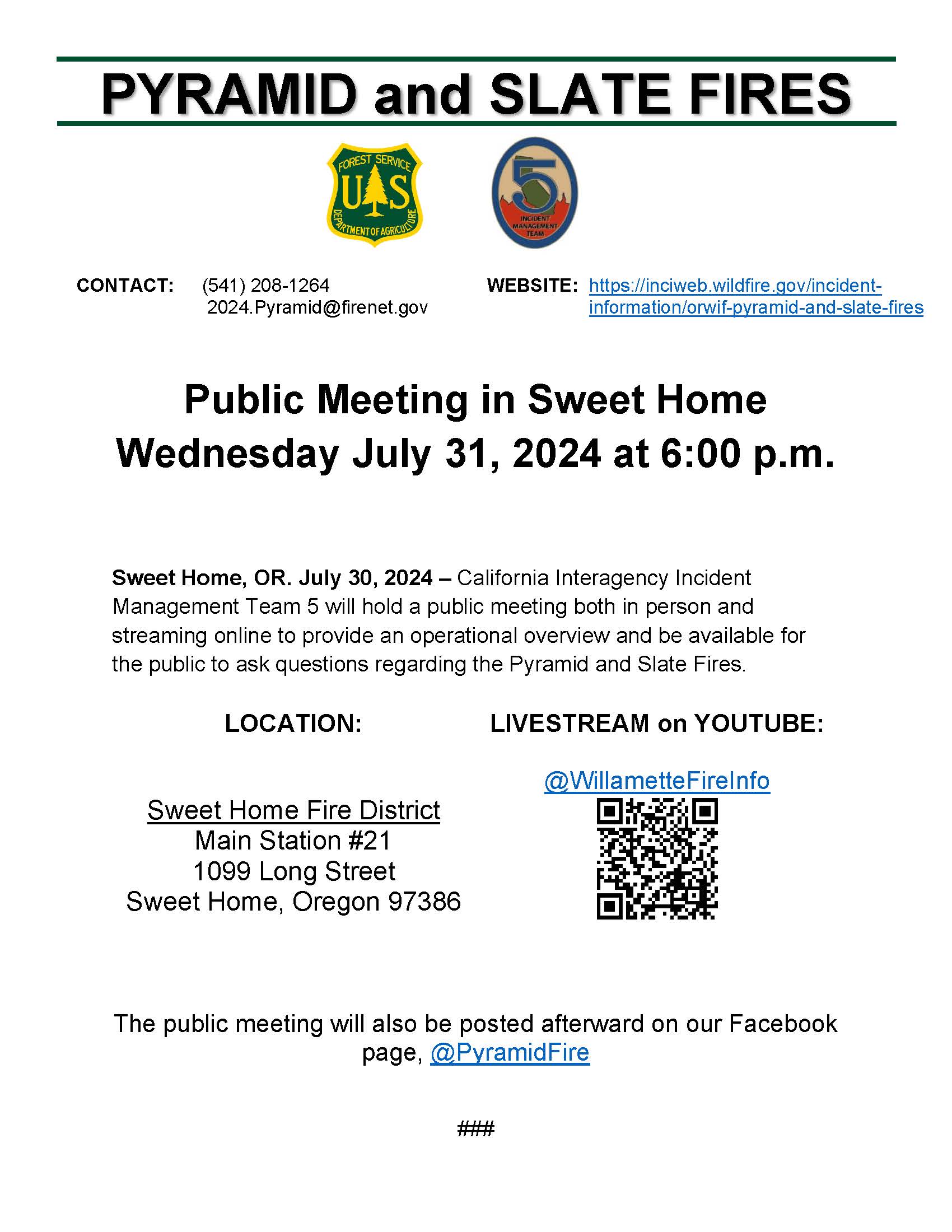
A community meeting will be held tomorrow Wednesday July 31, 2024, at 6:00p.m. at the Sweet Home Fire District, Main Station #21. 1009 Long Street, Sweet Home, Oregon 97386
This meeting will be livestreamed on YouTube @WillametteFireInfo. The public meeting will also be posted afterward on our Facebook page @PyramidFire.
Grouse Update 07 30 2024
Related Incident: Grouse
Publication Type: News
Incident Commander: D. Hammack
Location: 10 miles southwest of Wise River, MT
Start Date: 7/25/2024
Cause: Undetermined
Size: 230 acres
Resources on Site: 4 type 2 hand crews; 5 engines; 2 helicopters available to assist
Total Personnel: 116
KEY MESSAGES:
Numerous firefighting resources are present along the Pioneer Scenic Byway (Mt Hwy 73). Motorists in the area are urged to be aware of the increased traffic, slow down, and yield right-of-way to firefighting apparatus and vehicles.
Fire managers are urging people to stay out of the fire area, especially Pettengill Creek, Grouse Creek, Stine Creek, and the Stine Creek Road area, for safety reasons. Fire managers and agency officials are discussing necessary area, road, and trail closures. Ensuring public and firefighter safety and protecting life and property are of the utmost importance.
CURRENT STATUS/PLANNED ACTIONS:
Crews progressed with structure protection measures, working from the junction of Pettengill Road and along the Pioneer Scenic Byway to the north. They improved a section of existing line, utilizing both natural (marshy areas of Pettengill Creek) and manmade control features (fuel breaks previously constructed during the Alder Creek Fire of 2021). Other crews constructed additional fuel breaks northward along the Byway, utilizing natural rock features. Firefighters installed water-handling equipment (pumps, hoses, and sprinklers) around structures in the Pettengill Creek area.
Additional resources will be arriving today. Crews will continue with structure protection preparations, progressing northward along the Byway and identifying locations where fire suppression actions can be taken in the event the fire advances towards the Byway.
WEATHER AND FIRE BEHAVIOR:
The fire is moving primarily up the Grouse Creek drainage and sub-drainages. Both flanks or sides of the fire are moving actively, with fire backing downhill towards Pettengill Creek and spotting to the north towards Grouse Creek. The fire is burning mainly in a subalpine fir fuel model, in heavy timber on steep rocky terrain. Available fuels are unseasonably dry and include large amounts of standing dead and down trees. Fire behavior has been very active, including group tree torching on all flanks, short runs, and spotting. Fire activity increased yesterday, as afternoon build-up created gusty outflow winds.
Dead fuels along the ridges at the highest elevations are consuming completely. If winds align with terrain, in combination with the dry fuels, extreme fire behavior with active movement can be expected. These conditions pose additional hazards to firefighters, limiting access and affecting on-the-ground progress.
There is a chance of showers and thunderstorms throughout the day, with associated precipitation. Rain activity will increase late overnight Tuesday and into Wednesday morning. Thunderstorms are possible in the afternoon hours. Winds will be light with relative humidity at considerably higher levels Tuesday afternoon.
CLOSURES AND RESTRICTIONS:
A Temporary Flight Restriction (TFR) is in place over the fire area.
The Forest is in Stage 1 Fire Restrictions. Campfires are allowed only in a permanent metal fire grate/ring provided by the Forest Service in a designated, developed recreation site. Smoking is restricted to vehicles, in buildings, or in an area clear of flammable materials. Devices with an on/off switch that use LPG fuels are allowed in an area clear of flammable materials within 3 feet of the device.
Media Update 73027 Courtrock 07 30 2024
Related Incident: Courtrock Fire
Publication Type: News
Courtrock Fire fully lined, mop up continues to further containment
MONUMENT, Ore. – Firefighting efforts through last night’s shift attained a fully lined perimeter around the fire. Mop up efforts from ODF Team 1 and OSFM task forces will continue today to secure homes and increase overall containment.
Cougar Creek Fire Update 07 30 2024
Related Incident: Cougar Creek Fire
Publication Type: News
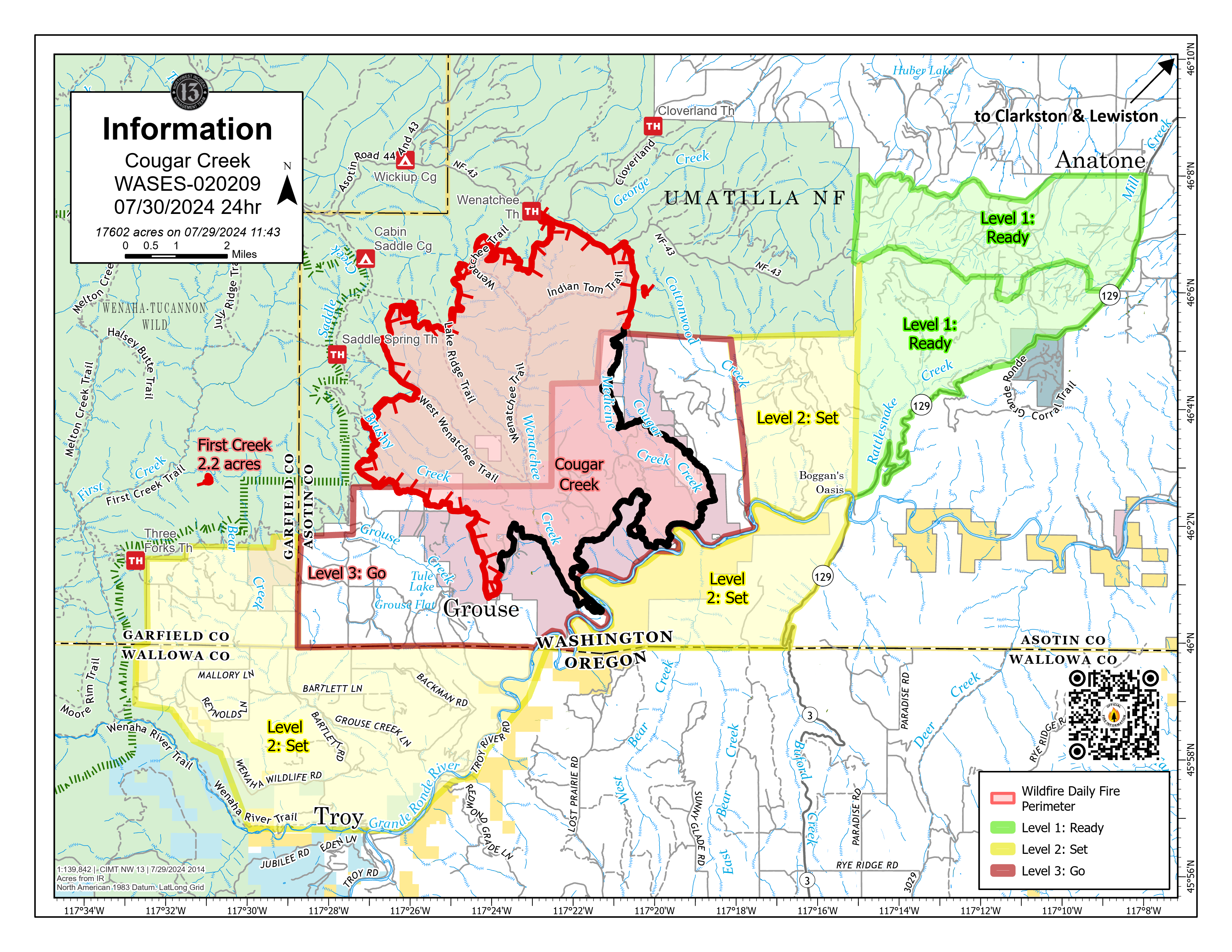
Cougar Creek Fire Update for Tuesday July 30, 2024
KEY MESSAGES:
Strong winds on the fire led to two small spot fires on the northeast side of the fire. . These spot fires merged as firefighters engaged. Hand crews dug line and placed hose line around the perimeter. Due to favorable visibility and light winds, air operations began bucket drops earlier yesterday than in previous days. The spot fire is now contained with a perimeter of 1.5 acres. Aviation resources were utilized in tandem with firefighters on the ground to aggressively engage the fire.
CURRENT STATUS:
On the southern end of Cougar Creek Fire, structure protection continues around Grouse Flats. Crews are patrolling current control lines from Wenatchee Creek drainage, west towards the 40 Road. Hand crews continue to mop up in this area in and around the fire edge.
An indirect line on Mallory Ridge has been completed to enhance contingency efforts. Crews have been making progress on mop-up operations and continue to patrol the southern portion of Hansen Ridge.
FIRE BEHAVIOR AND WEATHER:
Yesterday evening, the fire area received some rain, amounting to five-hundredths of an inch. This moisture helped slow fire progression but was not substantial enough for long-term beneficial effects. Today, an eastern wind will build higher pressure over the area, which will foster higher than average temperatures and lower relative humidities later in the week. This instability may promote active fire behavior.
EVACUATIONS AND CLOSURES:
Forest closure descriptions and maps are available online on the Umatilla National Forest Closure page. In Washington, evacuation notices are posted on the Asotin County Sheriff webpage and Asotin County Emergency Management Facebook page. Grande Ronde Road is closed from Troy, Oregon to Highway 129 junction in Washington. In Oregon, a level 2 evacuation is in effect for Wallowa County, including all of Grouse Flat from Bear Creek Rd north to the State boundary and the Garfield County line to Grande Ronde River.
Gwen Fire Daily Update 07 30 2024
Related Incident: 2024 Gwen Fire
Publication Type: News
Rocky Mountain Complex Incident Management Team Three
Bill Waln, Incident Commander
Location: 5 miles east Lapwai, Idaho Date Reported: July 24, 2024 Cause: Lightning
Size: 28,805 acres Containment: 10% Total Personnel: 224
Current Situation:
- Due to the hard work of the firefighters and local resources, the Gwen fire is now 10% contained. The containment is located along the fire’s perimeter south of the Arrow Bridge to just east of the intersection of the N. Tom Beall and Middle Tom Beall roads.
- The fire area received approximately two tenths (0.2) of an inch of rain over the last 12 hours.
- Firefighters will take the opportunity of the brief break in the weather to make progress in reducing the threat of the fire moving outside the current footprint.
- Crews will be walking the perimeter on the south and west portions of the fire mopping up or extinguishing hot spots along the fire’s edge. When fire managers are confident that the perimeter in these areas are secure, they will be added to the containment of the fire.
- Hazards from the fire remain along roadways and around structures within the fire perimeter. These hazards include fire traffic and firefighters along the roadways, falling fire-weakened trees, and rocks and debris on the roadways.
- Active fire remains in the Pine Creek Drainage. Crews and aviation resources were successful at keeping the fire in check yesterday and they will continue to focus cooling hot spots in the Pine Creek Drainage. Secondary containment lines have been established east of the drainage as a contingency plan if the fire were to spot across the drainage.
Evacuations: EVACUATIONS REMAIN IN PLACE -Level 1 Get Ready; Level 2 Get Set; Level 3 Go. For the safety of responders please Go if asked to leave. The fire behavior is very unpredictable and life threatening.
- Latah County Sheriff’s Office Level 1, 2, and 3 evacuation orders for multiple areas of the fire. Learn more at https://www.facebook.com/LatahCountySO and call: (208) 882-2216
- Nez Perce County Sheriff’s office has issued level 1, 2, and 3 evacuations orders for their county. Those are posted on their Facebook page: https://www.facebook.com/NezPerceCountySheriffsOffice.
- Nez Perce County Emergency Management Interactive Evacuation Map: https://bit.ly/3yewVv0
Air Quality Information: Please visit https://fire.airnow.gov/ for resources on smoke and air quality. Air quality monitors indicate unhealthy for sensitive groups in the Lapwai area.
Weather and Fire Behavior: Winds will be lighter today with a slight chance of thunderstorms. Relative humidity will remain lower today and temperatures will be 5 to 10 degrees cooler. Hot, dry conditions will return on Thursday.
Closures: The Idaho Transportation Department opened Highway 12 last night. Highway 3 corridor is now open as well. Hazards remain alone the highway, please use extreme caution when traveling in and around the fire area.
GWEN FIRE INFORMATION
Fire Information Phoneline: (208) 843-3534 (Time: 7am-7pm) Email: 2024.Gwen@firenet.gov
Facebook: @IdahoDepartmentofLands InciWeb: inciweb.wildfire.gov/incident-information/idids-2024-gwen-fire
Daily Update for the Sand Stone Fire Deer and Davenport Fires 07 30 2024
Related Incident: Sand Stone
Publication Type: News
Wind and fuel drive the Sand Stone Fire
Daily Update – Tuesday, July 30, 2024
Highlights: The Maricopa County Sheriff’s Office has moved the community of Sunflower to “set” status. “Set” status means residents should identify the closest shelter or safe space, prepare an emergency kit, listen to public health officials and be ready to leave the area. The Ready, Set, Go! program is a nationwide program to educate residents about steps to take during an emergency. Sign up for emergency alerts at ready.maricopa.gov.
Total personnel on all incidents: 306
Sand Stone Fire: Acres: 23,405 Containment: 0% Start Date: 7/25/2024 Fuels: Grass, brush
Operations: The Sand Stone Fire was moderately active throughout the day yesterday, growing to over 23,000 acres. The fire backed down towards Bartlett Lake with a small portion moving under the 345-kilovolt powerline operated by Arizona Public Service (APS). On the southeastern side, crews conducted strategic firing operations to create a buffer connecting Highway 87 to Forest Road 402. As the east side of the fire progresses towards Indian Springs Canyon, fire crews are planning to strategically ignite vegetation in this canyon to create a containment feature. To the south, aircraft will continue to support firefighters on the ground, dropping water buckets throughout the day to help slow and reduce fire activity. Ground crews are scouting and identifying existing roads to serve as holding features to prevent fire spread. In the east, night shift crews are working to hold the fire west of Highway 87 around Dos S Ranch. Preparations will continue today around the community of Sunflower, up the old Highway 87 to Forest Road 201. As additional firefighters are engaged across the fire area, crews are developing a structure protection plan and planning for primary and alternate firelines.
Deer Fire: Acres: 235 Containment: 0% Start Date: 7/17/2024 Fuels: Grass, brush, timber
Operations: The Deer Fire is burning within the Mazatzal Wilderness. Yesterday, firefighters monitored the fire by air as it continued to move slowly through the ponderosa pine forest. A reconnaissance flight will be conducted again today to get an updated acreage for this fire.
Davenport Fire: Acres: 447 Containment: 0% Start Date: 7/19/2024 Fuels: Grass, brush
Operations: The Davenport Fire was reported within the Mazatzal Wilderness and has not shown any fire activity for several days. Firefighters are continuing to monitor the fire for any new heat sources or growth.
Weather: Temperatures will remain in the mid- to upper 90s and the relative humidity will hover around 20%. Dry conditions with no thunderstorm activity can be expected across the area. Sustained wind speeds will be less than 15 mph, however, some occasional afternoon and early evening gusts upwards of 20-25 mph are possible.
Smoke: Smoke may be visible from Fountain Hills, Sunflower, Rio Verde, Goldfield, and unincorporated communities in the Rio Verde Foothills. An interactive smoke map at https://fire.airnow.gov/ allows you to zoom into your area to see the latest smoke conditions.
Closures: Southbound State Route 87 is closed between State Route 188 to Bush Highway. There is no estimated time to reopen the southbound lanes. See https://az511.gov/ for a map of the closure. The Tonto National Forest has issued a closure order for the Sand Stone Fire. More information can be found on the Tonto National Forest website: https://www.fs.usda.gov/alerts/tonto/alerts-notices/. Trail users should avoid using the Arizona National Scenic Trail near the fire area.
Safety: The health and safety of firefighters and the public are always the first priority. A temporary flight restriction (TFR) is in place over the area, which includes uncrewed aircraft or drones. Flying drones near wildfires is dangerous for pilots and firefighters and can bring wildfire suppression efforts to a halt. Know before you fly. If you fly, we can’t. More information on the dangers drones pose to wildland firefighting aircraft and personnel on the ground can be found at: https://uas.nifc.gov/.
More Information: https://inciweb.wildfire.gov/incident-information/aztnf-sand-stone /
480-409-9683 / https://www.facebook.com/TontoNationalForest / 2024.sandstone@firenet.gov
Community Meeting Recording 07 30 2024
Related Incident: Retreat
Publication Type: Announcement
Did you miss the community meeting from last time July, 29?
Watch it live here: https://www.youtube.com/watch?v=AuF8ctFhUnI