
Recreation Sites and Trails in Fire Area Closed Updated August 28th
Related Incident:
Publication Type: Closures
Barlow and Hood River Ranger District Fire Closure
Forest Order No. 06-06-06-20-06
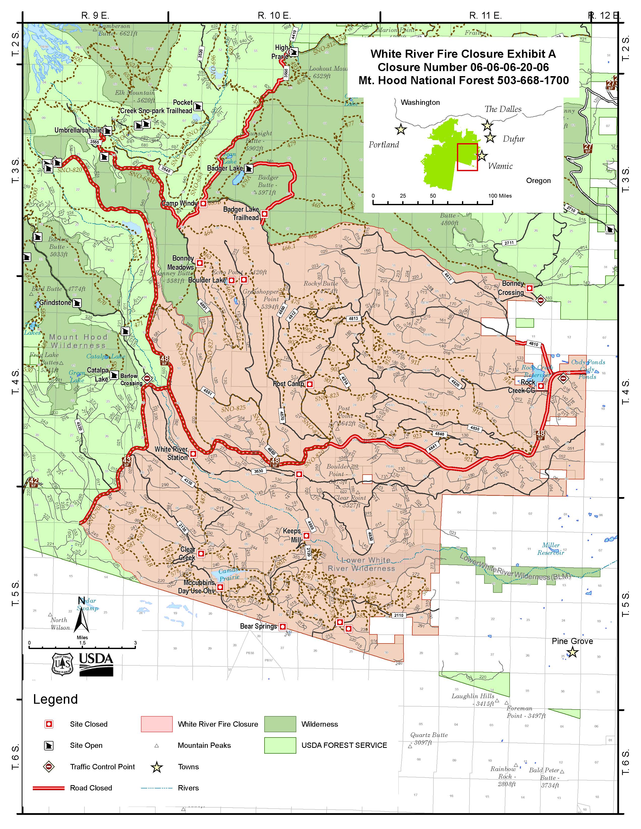
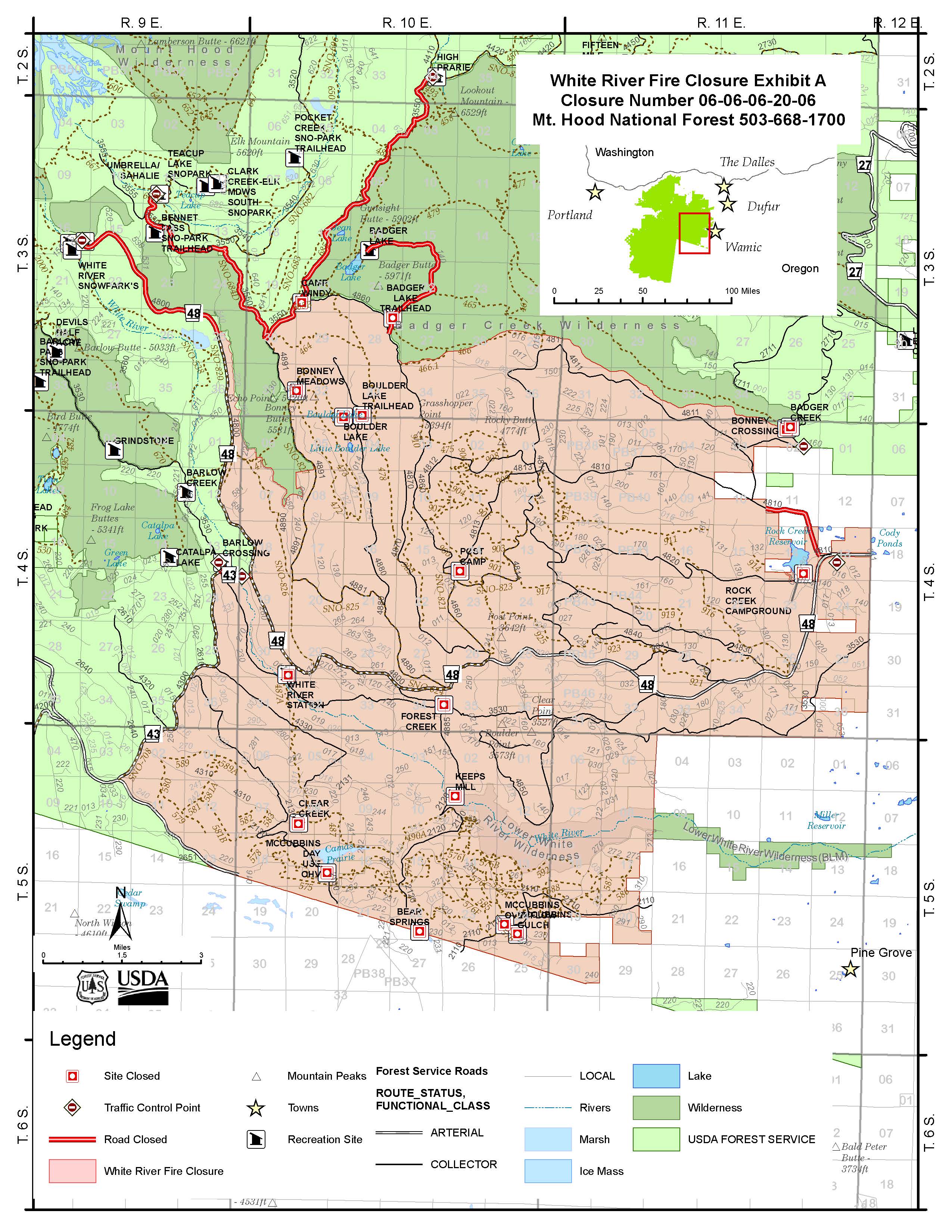
This closure includes all National Forest System lands, roads and trails administered by the Mount Hood National Forest, Barlow and Hood River Ranger Districts as depicted in Exhibit “A” within the following area:
Forest Service Road 3550 at the intersection of 4410 and 4420 south to Camp Windy then continues on Forest Road 3550 from Bennett Pass Snopark southeast to the junction with 4891.
All land, roads and trails east and southeast of the Badger Creek Wilderness and north of Forest Road 48 are closed beginning at the junction of Forest Road 48 and Highway 35.
All National Forest Lands south of the Badger Creek Wilderness to its southeast corner across from Bonney Crossing Campground are closed.
This closure extends south of Forest Road 48 at its junction with Forest Road 43 and extends to Highway 26 and State Highway 216.
The closure follows the southern and eastern end of the closure follow the forest boundary after State Highway 216 reaches the forest boundary in T5S, R9E, Section 13.
This closure affects the following trails:
- Crane Creek
- Crane Prairie
- Boulder Lake
- Forest Creek
- Hidden Meadows
- Bonney Meadows
- Threemile
- Camas
- Rimrock
- All of Rock Creek OHV Area
- All of McCubbins Gulch OHV Area
This closure affects the following recreation sites:
White River Station
Forest Creek
Keeps Mill
Boulder Lake
Little Boulder Lake
Post Camp
Camp Windy
Bonney Meadows
Bonney Crossing
Post Point OHV Staging Area
Gate Creek OHV Staging Area
Barlow Crossing
Rock Creek Day Use and Boat Launch
This closure affects the following campgrounds:
Rock Creek Campground
Clear Creek Campground
McCubbins Gulch Campground
Barlow and Hood River Ranger Districts Fire Closure 0606062006
Related Incident:
Publication Type: Closures
UNITED STATES DEPARTMENT OF AGRICULTURE
FOREST SERVICE
Barlow and Hood River Ranger Districts, Mt Hood National Forest
FOREST ORDER NO. 06-06-06-20-06
Barlow and Hood River Ranger District Fire Closure
Pursuant to 16 USC § 551 and 36 CFR 261.50 (a) and (b), and to provide for public and firefighter safety, the following
acts are prohibited within the Barlow and Hood River Ranger Districts of the Mt Hood National Forest, as shown on the
attached map (Exhibit A). This order supersedes order 06-06-06-20-05, signed August 25, 2020. This Order is effective
beginning 1200 August 27, 2020 and will remain in effect until October 31, 2020 or until rescinded.
PROHIBITIONS:
Going into or being upon National Forest System lands within the Fire Closure Area.
1. Going into or being upon an area closed for the protection of public health or safety. (36 CFR 261.53(e))
2. Being on a road. ( 36 CFR § 261.54(e))
3. Being on a trail. (36 CFR § 261.55(a))
CLOSURE AREA DESCRIPTION:
As depicted on “Exhibit A” all National Forest System Lands, roads and trails administered by the Mount Hood National
Forest, Barlow and Hood River Ranger Districts within the following area:
The Fire Closure Area Boundary begins on Forest Road 3550 at the intersection of 4410 and 4420 south to Camp
Windy then continues on Forest Road 3550 from Bennett Pass Snopark southeast to the junction with 4891. All
land, roads and trails east and southeast of the Badger Creek Wilderness and north of Forest Road 48 are closed
beginning at the junction of Forest Road 48 and Highway 35. All National Forest Lands south of the Badger
Creek Wilderness to its southeast corner across from Bonney Crossing Campground are closed. This closure
extends south of Forest Road 48 at its junction with Forest Road 43 and extends to Highway 26 and State
Highway 216. The closure follows the southern and eastern end of the closure follow the forest boundary after
State Highway 216 reaches the forest boundary in T5S, R9E, Section 13.
EXEMPTIONS:
Pursuant to Title 36 CFR 261.50(e), the following persons are exempt from this order:
(1) Any person with a permit specifically authorizing the otherwise prohibited act or omission.
(2) Any Federal, State, or local official or member of an organized rescue or firefighting force in the performance
of an official duty.
(3) Owners or lessees of land within the closed area.
These prohibitions are in addition to the general prohibitions in 36 CFR part 261, subpart A.
PURPOSE:
This closure is necessary to provide protection for forest users, firefighting personnel and natural resources from the
current fire hazards associated with existing and predicted wildfire activity.
Executed in Sandy, Oregon this 27th day of August, 2020.
RICHARD PERIMAN
Forest Supervisor
Mt Hood National Forest
Violations of these prohibitions are punishable by a fine of not more than $5,000 for an individual or $10,000 for an
organization, or imprisonment for not more than 6 months, or both. (16 U.S.C.551, and 18 U.S.C. 3559 and 3571)
White River Fire Update Aug 28 2020 NWIIMT 9
Related Incident:
Publication Type: News
Afternoon Update: 8/28/20 Fire activity picked up this afternoon as the heavy smoke over the fire area began lifting out. Firefighters are actively engaged and have made good progress with the support of air resources.
Morning Update: Friday, Aug. 28, 2020 The White River Fire moved significantly yesterday, crossing control lines to the east and spotting across the river to the south. It moved from national forest land to state and private lands. The fire threatened structures in Pine Grove, leading to a Level 3 “GO” Evacuation Order from the Wasco County Sheriff. A Level 3 Order means EVACUATE NOW.
Yesterday several crews on the ground and aircraft moved to initial attack, working spot fires lofted embers out to 2000 feet. Fire managers used several firefighting aircraft to help suppress fire where conditions allowed and were effective. Local firefighting resources assisted with structural protection near the community of Pine Grove. Because of the fire’s proximity to Pine Grove, the Governor declared a Conflagration Act enabling the State Fire Marshal to bring 15 structural protection engines to the fire. Also, the incoming Type 1 team (PNWIIMT 3) has added capacity including structural protection managers.
In addition to initial attack on the fire yesterday, fire crews continued to scout, evaluate, and implement primary control line options and evaluate and implement alternative opportunities. They will continue those activities today. The fire is now 9,791 acres. There are 614 personnel working the fire. Air quality: The monitor in Madras, OR shows moderate air quality for the area. With increased fire activity during athe day, air quality may move from moderate to poor. Flight Restriction: A Temporary Flight Restriction (TFR) is in effect prohibiting people from flying in the area. White River Fire Closures: The Mt Hood National Forest increased the closure area around the fire. For the latest closure information and specifics on closed campgrounds, recreation areas, trails and roads, see the forest Facebook page and Inciweb https://inciweb.nwcg.gov/incident/closures/7013/
Evacuations: The Wasco County Sheriff has issued the following Evacuation notices as of Thursday night, Aug. 27, 2020: Level 3 – GO: The area east from Bear Springs Ranger Station along Hwy 216 through Pine Grove to the intersection of Endersby Rd and 216, also included are all of Endersby Rd, Linns Mill Rd and Kelly Springs Rd, including the community of Pine Grove. EVACUATE NOW. Level 2 – GET SET Area from Back Walters Rd / Walters Rd / Kelly Springs Rd Intersection to Eldersby Rd / 216 Intersection along Victor Rd to the Claymier Lane/ Old Wapinita Hwy Intersection to Old Wapinita Hwy/ Wapinita Hwy/Reservation Road to Reservation Rd/Back Walters Rd Intersection. Level 2 – Get Set: All residences on Smock Road west of the intersection of Smock Road and Ayres Road to include all residences on Barber Lane and Farlow Road. Level 1 – Be Ready: The area east from Bear Springs Ranger Station along Hwy 216 through Pine Grove to the intersection of Endersby Rd and 216, also included are all of Endersby Rd, Linns Mill Rd and Kelly Springs Rd. Level 1 – Be Ready: All residences on Smock Road west of the intersection of Smock Road and Ayres Road toall residences on Barber Lane and Farlow Road. Level 1 – Be Ready: The Sportsman’s Park.
Wasco County Citizen Alert System
Related Incident:
Publication Type: Announcement
Wasco County Citizen Alert
Receive alerts about emergencies and other important community messages by signing up for the Citizen Alert Emergency Notification System. This notification system enables Emergency Response Agencies to provide you with critical information quickly in a variety of situations, such as severe weather, wildfires, floods, street and road closures, missing persons, law enforcement activities and evacuation notifications.
You will receive time-sensitive messages wherever you specify, such as your home, cell, or business phone, email, text messages, hearing impaired receiving devices, and more. You pick where, you pick how. Individuals with disabilities who need assistance can register by calling the Wasco County Communications Manager at 541-506-2760.
Important: Once you provide your phone numbers and email in step #3, you MUST enter contact preferences in order to receive emergency and/or community alerts.
https://member.everbridge.net/453003085612392/login
White River Fire Update Aug 27 2020 NWIIMT 9
Related Incident:
Publication Type: News
Condolences: An Honor Guard procession today from Portland to Hood River will commemorate the life of Thomas Duffy, age 40, of Bozeman, Montana. On Aug. 24, 2020, Duffy flying a Type 1 K-MAX helicopter died while conducting bucket drops on the White River Fire on Mt. Hood National Forest. The investigation into the crash continues. We extend our deepest sympathy to Tom’s family and friends.
Update on the fire: Yesterday, the eastern finger from Tuesday’s growth did not move significantly, and fire crews were able to construct hand line and dozer line along much of the north flank of the finger. The fire spotted across the White River upstream from Keep’s Mill Campground near river mile 30. It is estimated at 30 acres.
The fire is now 2775 acres. There are three Type 1 crews, 12 Type 2 crews, three Type 1 (large) and 1 Type 3 (light) helicopters assigned to the fire. There are currently 543 personnel on the fire, with four more crews arriving today. Management of the fire will transition on Saturday from NWIIMT 9 (Goff) to PNW IIMT3 (Livingston), a Type 1 incident management team.
Today, a relatively stable weather pattern will prevail through Friday with warm and dry conditions. There will be some increase in the winds in the afternoon, but night and early morning winds will be terrain driven. Relative humidity will be low during the day, with moderate recovery at night.
Fire crews will continue to scout, evaluate, and implement primary control line options and evaluate and implement alternative opportunities. They will continue firing operations as conditions allow. They will identify and secure spot fires, and monitor fire perimeter.
Flight Restriction: A Temporary Flight Restriction (TFR) is in effect prohibiting people from flying in the area.
White River Fire Closures: The Mt Hood National Forest plans to increase the closure area around the fire. For the latest closure information and specifics on closed campgrounds, recreation areas, trails and roads, see the forest Facebook page and Inciweb https://inciweb.nwcg.gov/incident/closures/7013 /
Evacuations: The Wasco County Sheriff has extended the Level 1 "Be Ready" evacuation alert to addition areas as of Wednesday night, Aug. 26, 2020:
* The area east from Bear Springs Ranger Station along Hwy 216 through Pine Grove to the intersection of Endersby Rd and 216, also included are all of Endersby Rd, Linns Mill Rd and Kelly Springs Rd.
* All residences on Smock Road west of the intersection of Smock Road and Ayres Road to include all residences on Barber Lane and Farlow Road.
* The "Be Ready" notice will remain in place for Sportsman’s Park.
Sheriffs in Oregon and Montana identify pilot
Related Incident:
Publication Type: News
Wasco County Sheriff’s Office Release 08/26/20
On August 24, 2020 a pilot flying a Type 1 K-MAX helicopter died while conducting bucket drops while fighting the White River Fire on Mt. Hood National Forest.
Thomas Duffy, a 40 year old male, of Bozeman, Montana, was flying for a contracted company supporting the U.S. Forest Service’s fire suppression efforts on the forest.
Next of kin notifications have been completed.
The Wasco County Sheriff’s Office would like to extend our deepest sympathy to the family and friends of Thomas Duffy.
The Wasco County Sheriff’s Office has been in contact with the Office of Sheriff, Gallatin County, Montana. Attached is their press release and a photo regarding Thomas Duffy.
We have also been in contact with the Wildland Firefighter Foundation in Bosie, ID. The Wildland Firefighter Foundation also made the following statement:
“Wildland Firefighter Foundation’s main focus is to help families of firefighters killed in the line of duty and to assist injured firefighters and their families. We honor and acknowledge past, present, and future members of the wildland firefighting community, and partner with private and interagency organizations to bring recognition to wildland firefighters.
Wildland firefighters represent the diversity of the land they protect. They are federal, state and local firefighters, private sector firefighters, interface firefighters, and volunteers from rural communities and towns across the United States.
The WFF has been intimately involved with the Duffy Family through this traumatic experience. Under a Contractor situation protocol and resources are very different and the Foundation strives to step in and fill those voids. We have been helping assist with Honor Watch. We have been assisting along with the Agency for family involvement. We've been working directly with Funeral Homes in both Oregon and Montana ensuring the correct paperwork is in place. We've basically been connecting the dots for everyone involved.” Director Burke Minor, WFFoundation.org
The investigation continues by our federal partners into the cause of this crash.
Gallatin County Sheriff’s Office Release
(Gallatin County, Mont.)
It is with great sadness that Gallatin County Sheriff’s Office announces that Tom Duffy, a Gallatin County Sheriff’s Search and Rescue (SAR) helicopter pilot, was killed in a firefighting accident in Oregon Monday. He was conducting bucket drops on the White Fire to help firefighters battle the blaze, which was burning in rough terrain in Mt Hood National Forest.
Tom is the third generation of the Duffy family to fly rescue missions for SAR. He has flown SAR rescue missions for 20 years and his most recent missions was on Aug 15, when he flew 3 times for the GCSAR helicopter team. Tom was a world-class rescue pilot who instilled confidence in SAR volunteers on every mission. He was a big man with a big heart who brought calm and skill to every mission.
When God opened a door, Tom walked through it, which led him to many adventures and skills. In addition to flying, he was a husband, father, business owner, and church member. He went big in everything he did and will be deeply missed in the GCSAR community and beyond.
Helicopter accident
Related Incident:
Publication Type: News
Green Ridge Fire Update September 1
Related Incident:
Publication Type: News
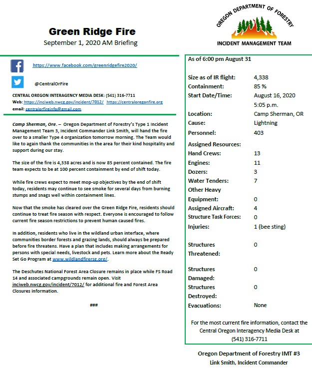
Camp Sherman, Ore. – Oregon Department of Forestry’s Type 1 Incident Management Team 3, Incident Commander Link Smith, will hand the fire over to a smaller Type 4 organization tomorrow morning. The Team would like to again thank the communities in the area for their kind hospitality and support during our stay.
Green Ridge Fire Update for August 31
Related Incident:
Publication Type: News
###
Smoke Outlook August 30
Related Incident:
Publication Type: News
Smoke Outlook for 8/30 - 8/31 North Central Oregon Issued at: 2020-08-30 07:53 PDT (see attached)
Fire Large wind-driven runs were observed on wildfires yesterday as dry air and high winds moved into the area. Today, cooler air and lighter winds will moderate fire spread and result in creeping and occasional tree torching fire behavior on the Lionshead and White River fires. Even cooler temperatures and increasing relative humidity arrive tomorrow as a second weak cold front moves into the area. This should moderate fire intensity even more. No precipitation is expected. A return to warmer and drier conditions Tuesday through the end of the week.
Smoke Yesterday's cold front passage brought with it hours of high winds which scoured smoke out of most of the forecast area. These winds also increased fire growth, and that smoke lofted to the southeast and surfaced in the southeast portion of the forecast area, where unhealthy levels of smoke were recorded overnight in the town of Burns. Air quality should improve to "good" in Burns today as west to northwest winds move smoke out of that area. Air quality modeling shows smoke impacts to be mostly local and southeast of the wildfires. Periods of light smoke can be anticipated elsewhere.
Daily AQI Forecast for Aug 30, 2020 *
Yesterday Sat Forecast Sun Mon Station hourly 8/29 Comment for Today Sun, Aug 30 8/30 8/31
Madras
Redmond
Sisters
Prineville
Bend
La Pine
John Day
Burns
Issued by USFS Wildland Fire Air Quality Response Program www.wildlandfiresmoke.net
North Central Oregon Current Outlook tools.airfire.org/outlooks/northcentraloregon Smoke and Health Info www.airnow.gov/index.cfm?action=smoke.index *
Good None
Moderate Unusually sensitive individuals should consider limiting prolonged or heavy exertion.
USG People within Sensitive Groups should reduce prolonged or heavy outdoor exertion.
Unhealthy People within Sensitive Groups should avoid all physical outdoor activity.
Very Unhealthy Everyone should avoid prolonged or heavy exertion.
Good air quality this morning moving into moderate this afternoon.
Good air quality this morning with periods of light smoke this afternoon.
Good air quality this morning moving into moderate this afternoon.
Good air quality this morning with periods of light smoke this afternoon.
Good air quality this morning with periods of light smoke this afternoon.
Good air quality this morning with periods of light smoke this afternoon.
Good air quality this morning with periods of light smoke this afternoon.
Moderate air quality this morning improving throughout the day.