
Smoke Report for Tuesday September 1 2020
Related Incident:
Publication Type: News
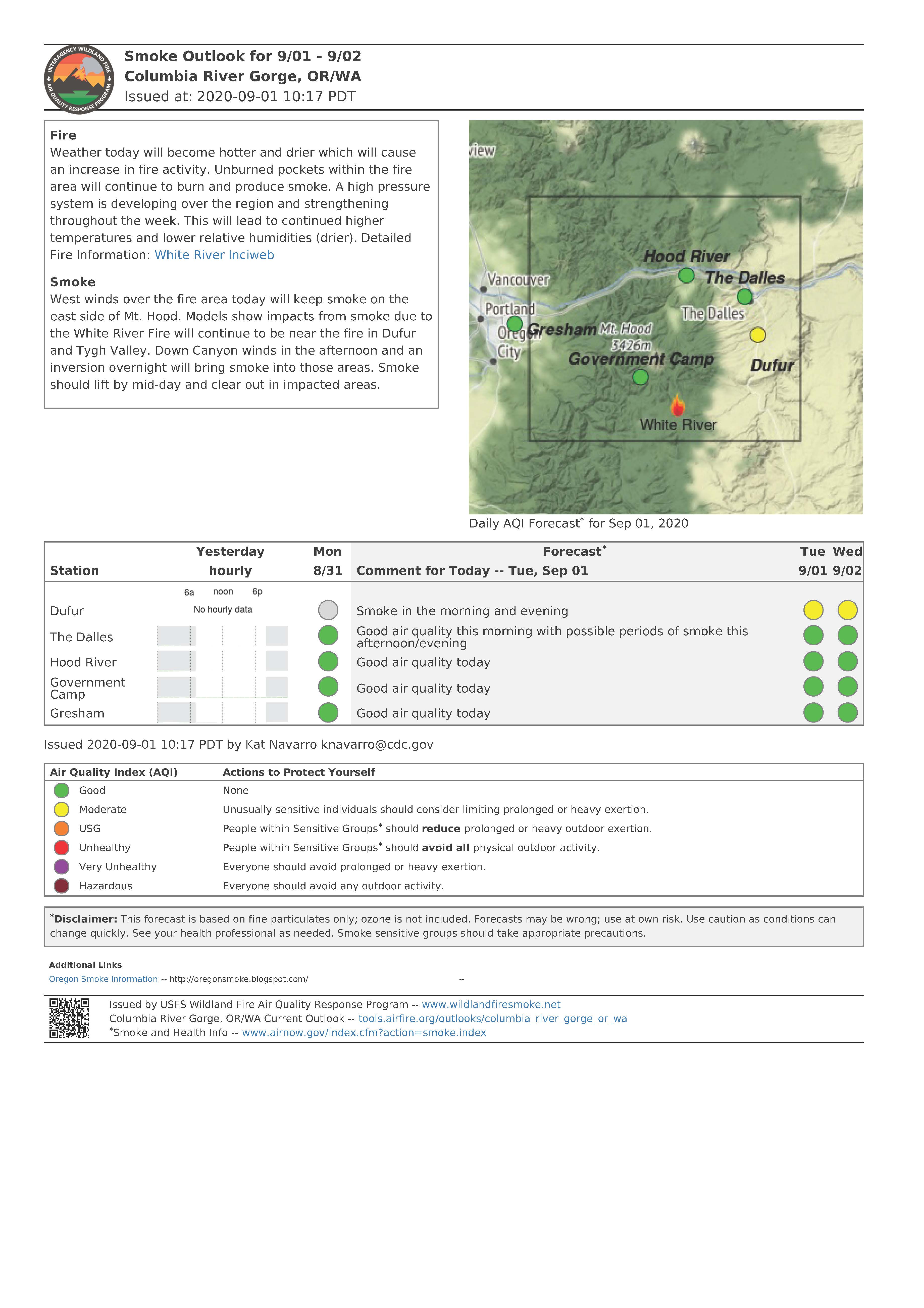
"West winds over the fire area today will keep smoke on the east side of Mt. Hood." See below for today's smoke outlook
Daily Update for September 1 2020
Related Incident:
Publication Type: News
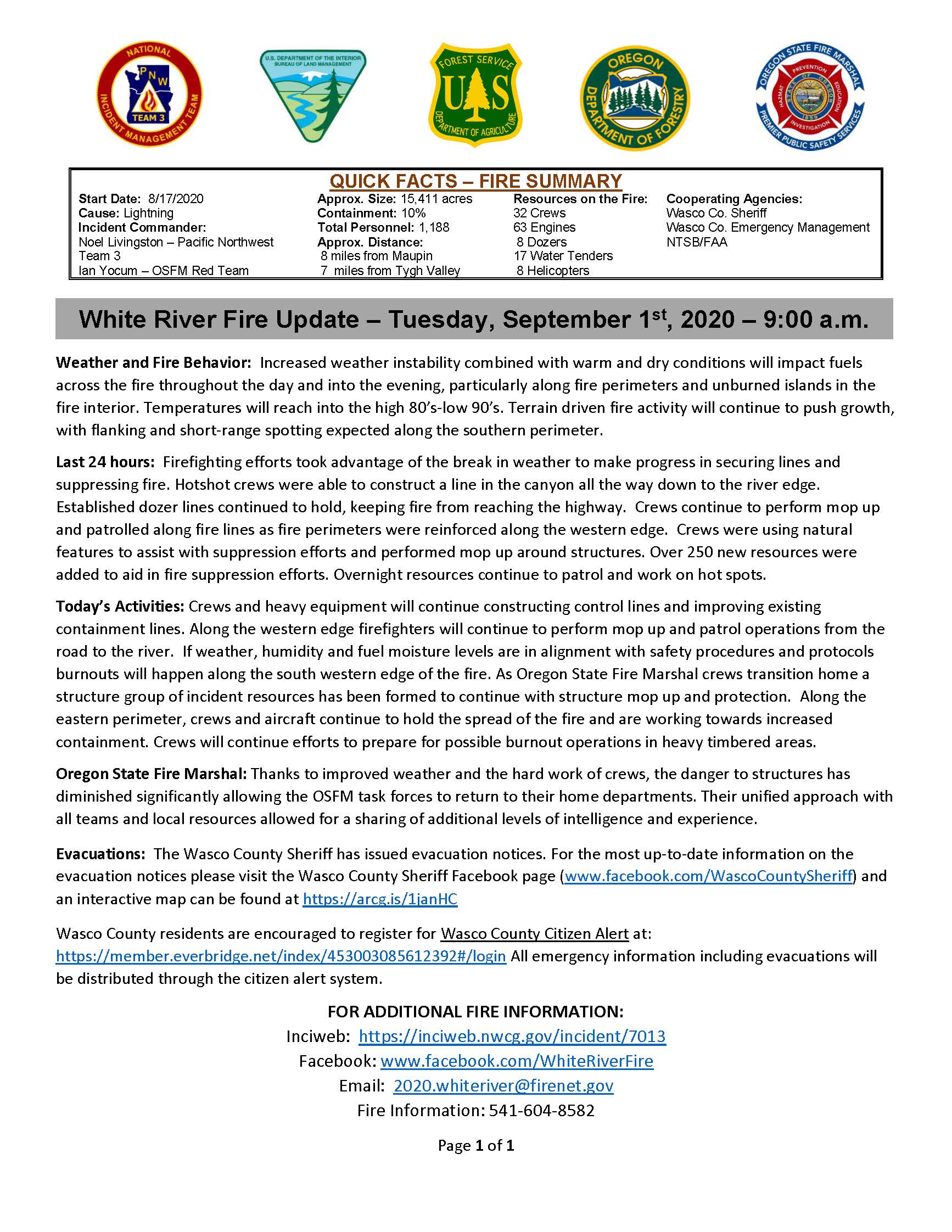
Quick Facts - Fire Summary
Start Date: 8/17/2020
Cause: Lightning
Incident Commander: Noel Livingston, Pacific Northwest Team 3
Approximate Size: 15,411 acres
Containment: 10%
Total Personnel: 1,188
Approximate Distance: 8 miles from Maupin/7 miles from Tygh Valley
Resources on the Fire:
32 crews
63 engines
8 dozers
17 water tenders 8
helicopters
Cooperating Agencies:
Wasco County Sheriff
Wasco County Emergency Management
NTSB/FAA
Weather and Fire Behavior: Increased weather instability combined with warm and dry conditions will impact fuels across the fire throughout the day and into the evening, particularly along fire perimeters and unburned islands in the fire interior. Temperatures will reach into the high 80’s-low 90’s. Terrain driven fire activity will continue to push growth, with flanking and short-range spotting expected along the southern perimeter.
Last 24 hours: Firefighting efforts took advantage of the break in weather to make progress in securing lines and suppressing fire. Hotshot crews were able to construct a line in the canyon all the way down to the river edge. Established dozer lines continued to hold, keeping fire from reaching the highway. Crews continue to perform mop up and patrolled along fire lines as fire perimeters were reinforced along the western edge. Crews were using natural features to assist with suppression efforts and performed mop up around structures. Over 250 new resources were added to aid in fire suppression efforts. Overnight resources continue to patrol and work on hot spots.
Today’s Activities: Crews and heavy equipment will continue constructing control lines and improving existing containment lines. Along the western edge firefighters will continue to perform mop up and patrol operations from the road to the river. If weather, humidity and fuel moisture levels are in alignment with safety procedures and protocols burnouts will happen along the south western edge of the fire. As Oregon State Fire Marshal crews transition home a structure group of incident resources has been formed to continue with structure mop up and protection. Along the eastern perimeter, crews and aircraft continue to hold the spread of the fire and are working towards increased containment. Crews will continue efforts to prepare for possible burnout operations in heavy timbered areas.
Oregon State Fire Marshal: Thanks to improved weather and the hard work of crews, the danger to structures has diminished significantly allowing the OSFM task forces to return to their home departments. Their unified approach with all teams and local resources allowed for a sharing of additional levels of intelligence and experience.
Evacuations: The Wasco County Sheriff has issued evacuation notices. For the most up-to-date information on the evacuation notices please visit the Wasco County Sheriff Facebook page (www.facebook.com/WascoCountySheriff) and an interactive map can be found at https://arcg.is/1janHC
Wasco County residents are encouraged to register for Wasco County Citizen Alert at: https://member.everbridge.net/index/453003085612392#/login All emergency information including evacuations will be distributed through the citizen alert system.
FOR ADDITIONAL FIRE INFORMATION:
Inciweb: https://inciweb.nwcg.gov/incident/7013
Facebook: www.facebook.com/WhiteRiverFire
Email: 2020.whiteriver@firenet.gov
Fire Information: 541-604-8582
Daily Update for August 31 2020
Related Incident:
Publication Type: News
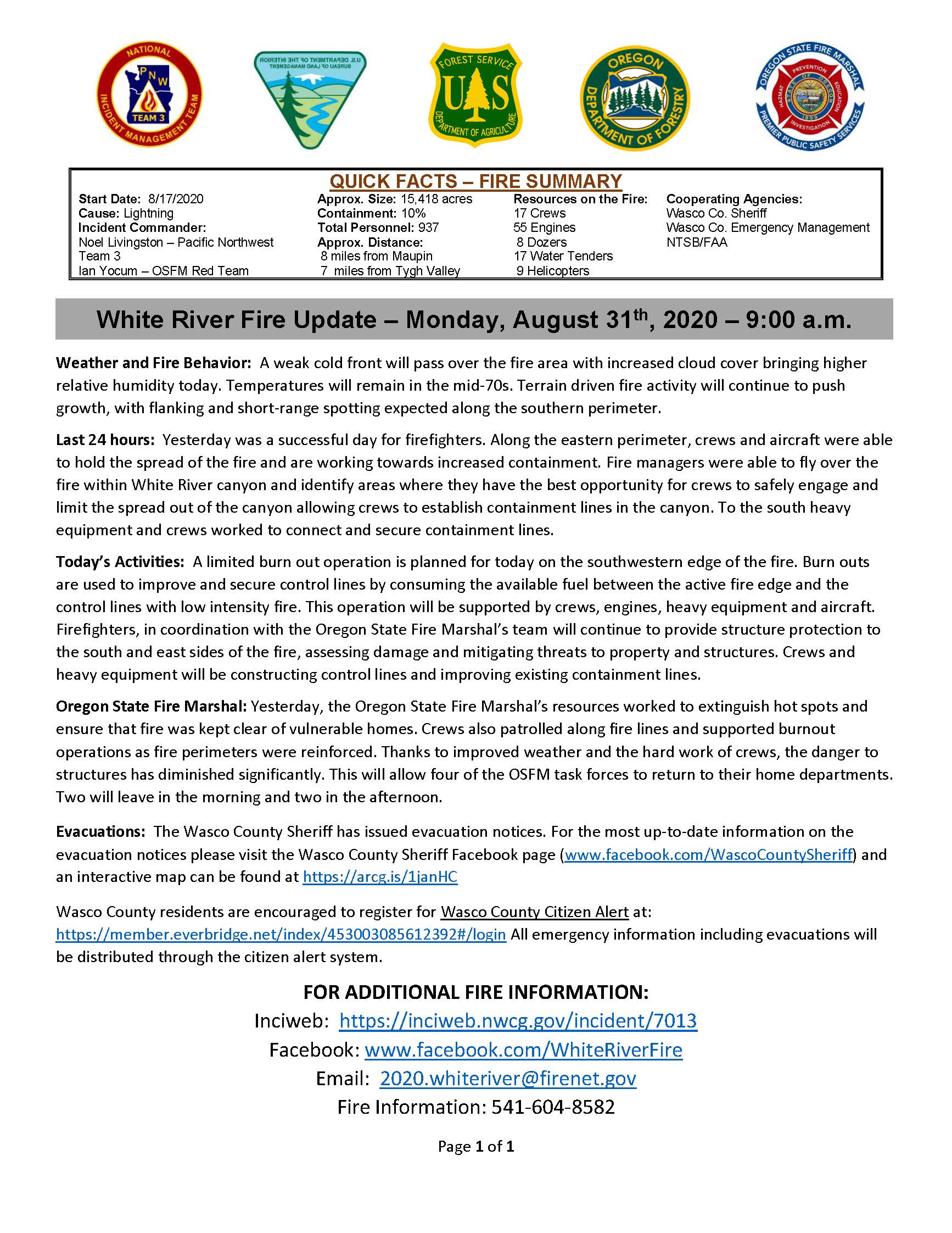
Quick Facts - Fire Summary
Start Date: 8/17/2020
Cause: Lightning
Incident Commander: Noel Livingston, Pacific Northwest Team 3 and Ian Yocum, Office of State Fire Marshal Red Team
Approximate Size: 15,418 acres
Containment: 10%
Total Personnel: 937
Approximate Distance: 8 miles from Maupin/7 miles from Tygh Valley
Resources on the Fire:
17 crews
55 engines
8 dozers
17 water tenders
9 helicopters
Cooperating Agencies:
Wasco County Sheriff
Wasco County Emergency Management
NTSB/FAA
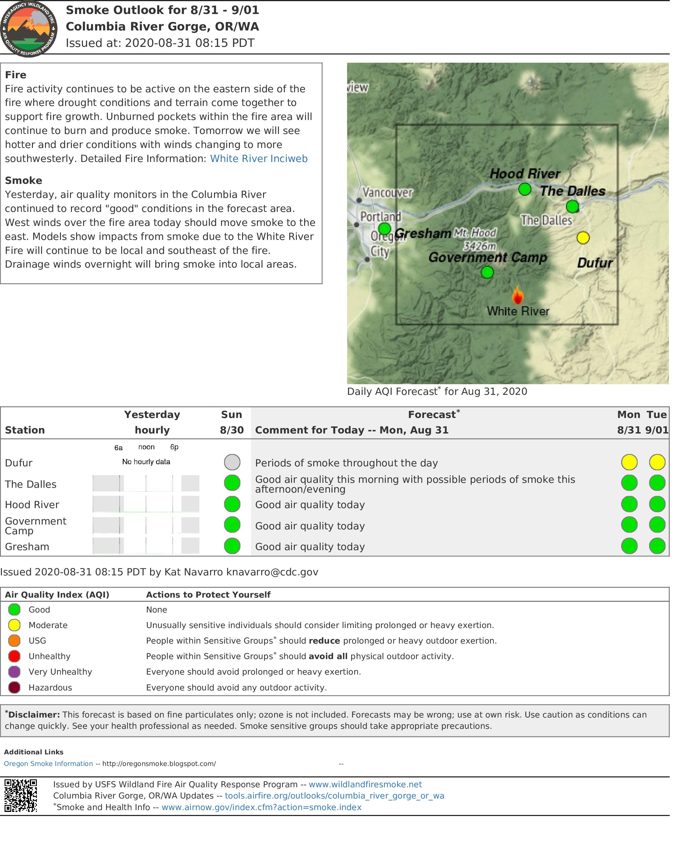
Weather and Fire Behavior: A weak cold front will pass over the fire area with increased cloud cover bringing higher relative humidity today. Temperatures will remain in the mid-70s. Terrain driven fire activity will continue to push growth, with flanking and short-range spotting expected along the southern perimeter.
Last 24 hours: Yesterday was a successful day for firefighters. Along the eastern perimeter, crews and aircraft were able to hold the spread of the fire and are working towards increased containment. Fire managers were able to fly over the fire within White River canyon and identify areas where they have the best opportunity for crews to safely engage and limit the spread out of the canyon allowing crews to establish containment lines in the canyon. To the south heavy equipment and crews worked to connect and secure containment lines.
Today’s Activities: A limited burn out operation is planned for today on the southwestern edge of the fire. Burn outs are used to improve and secure control lines by consuming the available fuel between the active fire edge and the control lines with low intensity fire. This operation will be supported by crews, engines, heavy equipment and aircraft. Firefighters, in coordination with the Oregon State Fire Marshal’s team will continue to provide structure protection to the south and east sides of the fire, assessing damage and mitigating threats to property and structures. Crews and heavy equipment will be constructing control lines and improving existing containment lines.
Oregon State Fire Marshal: Yesterday, the Oregon State Fire Marshal’s resources worked to extinguish hot spots and ensure that fire was kept clear of vulnerable homes. Crews also patrolled along fire lines and supported burnout operations as fire perimeters were reinforced. Thanks to improved weather and the hard work of crews, the danger to structures has diminished significantly. This will allow four of the OSFM task forces to return to their home departments. Two will leave in the morning and two in the afternoon.
Evacuations: The Wasco County Sheriff has issued evacuation notices. For the most up-to-date information on the evacuation notices please visit the Wasco County Sheriff Facebook page (www.facebook.com/WascoCountySheriff) and an interactive map can be found at https://arcg.is/1janHC
Wasco County residents are encouraged to register for Wasco County Citizen Alert at: https://member.everbridge.net/index/453003085612392#/login All emergency information including evacuations will be distributed through the citizen alert system.
FOR ADDITIONAL FIRE INFORMATION:
Inciweb: https://inciweb.nwcg.gov/incident/7013
Facebook: www.facebook.com/WhiteRiverFire
Email: 2020.whiteriver@firenet.gov
Fire Information: 541-604-8582
LIVE Update Tonight Sunday August 30th at 430 pm
Related Incident:
Publication Type: Announcement
Incident Commander Trainee Johnson advised "today's conditions will be more favorable for firefighting" during our morning video briefing. Tune in to www.facebook.com/WhiteRiverFire at 4:30 p.m. today (August 30th) for a LIVE update from fire personnel and cooperating agencies. You do not need a Facebook account to participate.
We hope to see you there!
Smoke Outlook for August 31 and September 1
Related Incident:
Publication Type: News
Yesterday, air quality monitors in the Columbia River continued to record “good” conditions in the forecast area. West winds over the fire area today should move smoke to the east. Models show impacts from smoke due to the White River Fire will continue to be local and southeast of the fire.
Daily Update for August 30 2020
Related Incident:
Publication Type: News
QUICK FACTS – FIRE SUMMARY
Start Date: 8/17/2020
Approx. Size: 14,391 acres
Incident Commander: Noel Livingston, Pacific Northwest Team 3 and Ian Yocum, Office of State Fire Marshal Red Team
Total Personnel: 781
Resources on the Fire:
18 Crews
19 Engines
7 Dozers
9 Water Tenders
9 Helicopters
Cause: Lightning
Containment: 10%
Cooperating Agencies:
Wasco Co. Sheriff
Wasco Co. Emergency Management
NTSB/FAA
Approx. Distance:14 miles from Maupin
7 miles from Tygh Valley
Weather and Fire Behavior: Temperatures and winds will moderate considerably today. Relative humidity is expected to be between the mid-teens and mid-twenties. Despite the cooler temperatures, extreme drought conditions still exist across the area. Fuels are very dry and the fire is moving quickly through the open grasses and fields.
Last 24 hours: The east side of the fire saw significant fire activity both on the north and south corners, beginning early in the morning and continuing throughout the day. The fire followed the White River canyon, burning actively and making runs up and out of the canyon and spotting on the south side of the river. As the fire transitioned into the fine grasses it moved rapidly towards Juniper Flat where crews and engines worked to provide structure protection. Both fixed wing aircraft and helicopters were able to work the north and south sides of the fire, supporting crews on the ground with water and retardant. On the west side of the fire, crews continued to patrol and hold the containment lines on both the north and south edges. Overnight firefighters remained focused on structure protection and monitoring the progress of the fire in White River Canyon. Despite the challenging weather and fire behavior, there have been no structures damaged or lost.
Today’s Activities: Firefighters will continue to provide structure protection on both the south and east portions of the fire while also assessing any threats to the values at risk, including residence. If conditions allow, both fixed wing aircraft and helicopters will be working along the fire perimeter. On the west side of the fire crews will continue line construction, holding and improving containment around the perimeter. Fire managers will be evaluating options for controlling the fire on the south side of the White River corridor, while also continuing to support structure protection along side the Oregon State Fire Marshal’s team.
Oregon State Fire Marshal: Yesterday, the Oregon State Fire Marshal’s Task Forces and our partners were busy protecting structures from fire that in some cases burned right up to the foundations. Firefighters were either able to extinguish the fire or guide it away from the homes. Local volunteer firefighters played a big role in protecting the community. Overnight and tomorrow firefighters will be out again working minimize this fire’s impact.
Evacuations: Notices are available on the Wasco County Sheriff Facebook page (www.facebook.com/WascoCountySheriff) and an interactive map can be found at https://arcg.is/1janHC
Wasco County residents are encouraged to register for Wasco County Citizen Alert at: https://member.everbridge.net/index/453003085612392#/login All emergency information including evacuations will be distributed through the citizen alert system.
LEVEL 3 – GO
All residences on Smock Road west of the intersection of Smock Road and Ayres Road to include all residences on Ayres Road and on Barber Lane and Barlow Road have now been placed on Level 3 GO Evacuation Notice.
Pine Grove and all of Juniper Flat area to Hwy 197
LEVEL 2 – GET SET
The area from Woodcock Rd to Driver Rd to the intersection of Smock and Ayres Rd to include Muller Rd.
Level 2 Get SET for the area east of HWY 197 to include Old Wapinita to include all of Oak Springs Rd to the Deschutes River
LEVEL 1 – GET READY
Sportsman's Park, Pine Hollow, Wamic, all of Tygh Valley to Pine Hollow, west side Hwy 197, to include the beginning of Badge Creek Rd, Fairgrounds Rd to the Intersection of Shadybrook and Fairgrounds Rd going east to Hwy 197, includes Davidson Grade Rd, Tygh valley Rd, Wamic Market Rd and Ross Road.
City of Maupin West side of the Deschutes to include all roads up to Old Wapinita/ HWY 197 intersection.
Area Closures: Forest closure exists on the Mt. Hood National Forest. For updated forest closures associated with the White River Fire, including road, trail and recreation sites please check: www.fs.usda.gov/detailfull/mthood/alerts-notices/?cid=stelprdb5191108&width=full
FOR ADDITIONAL FIRE INFORMATION:
Inciweb: https://inciweb.nwcg.gov/incident/7013
Facebook: www.facebook.com/WhiteRiverFire
Email: 2020.whiteriver@firenet.gov
Fire Information: 541-604-8582
Wasco County Sheriff Evacuation Levels
Related Incident:
Publication Type: Announcement
Visit the Wasco County Sheriff's Office Facebook page for official evacuation updates: www.facebook.com/WascoCountySheriff
Evacuation Areas and levels as of 08/29/20 11:30 p.m.:
LEVEL 3 GO: All residences on Smock Road west of the intersection of Smock Road and Ayres Road to include all residences on Ayres Road and on Barber Lane and Barlow Road have now been placed on Level 3 GO Evacuation Notice.
LEVEL 3 GO: All of Juniper Flat area to Hwy 197.
LEVEL 2 GET SET: for the area from Woodcock Rd to Driver Rd to the intersection of Smock and Ayres Rd to include Muller Rd.
LEVEL 2 GET SET: for the area east of HWY 197 to include Old Wapinita to include all of Oak Springs Rd to the Deschutes River.
LEVEL 1 GET READY: for the area of Sportsman's Park, Pine Hollow, Wamic, all of Tygh Valley to Pine Hollow, west side Hwy 197, to include the beginning of Badge Creek Rd, Fairgrounds Rd to the Intersection of Shadybrook and Fairgrounds Rd going east to Hwy 197, includes Davidson Grade Rd, Tygh valley Rd, Wamic Market Rd and Ross Road.
LEVEL 1 GET READY: for the City of Maupin West side of the Deschutes to include all roads up to Old Wapinita/ HWY 197 intersection.
Evening Fire Update August 29th
Related Incident:
Publication Type: Announcement
Predicted winds pushed the fire toward the east today, resulting in changes to evacuation levels. No structures were lost. Firefighters were supported by helicopters as they provided structure protection. Elsewhere on the fire perimeter, firefighters worked to hold the fire within containment line. Residents are encouraged to sign-up for Wasco County Citizen Alerts at https://member.everbridge.net/453003085612392/login.
Facebook Live Fire Update August 29 2020
Related Incident:
Publication Type: Announcement
Recording of fire updates can be viewed at: https://www.facebook.com/WhiteRiverFire/videos/2432629007036916
A Facebook account is not required to view.
White River Fire Update Saturday August 29 2020
Related Incident:
Publication Type: News
QUICK FACTS – FIRE SUMMARY
Start Date: 8/17/2020
Approx. Size: 11,184 acres
Resources on the Fire:
Cooperating Agencies:
Cause: Lightning
Containment: 10%
19 Crews
Wasco Co. Sheriff
Incident Commander:
Total Personnel: 819
19 Engines
Wasco Co. Emergency Management
Noel Livingston – Pacifc Northwest Team 3
Ian Yocum – OSFM Red Team
Approx. Distance:
14 miles from Maupin
11 miles from Tygh Valley
5 Dozers
8 Water Tenders
7 Helicopters
Oregon Department of Forestry
Oregon State Fire Marshal
NTSB/FAA
FACEBOOK LIVE EVENT: There will be a Facebook Live Update at 6:00 p.m. on the White River Fire Information Facebook Page. www.facebook.com/WhiteRiverFire
Weather and Fire Behavior: A Red Flag Warning will be in effect through 11:00 p.m. Saturday evening. A dry cold front is expected to pass through the area bringing strong west winds between 20-25 mph and gusts up to 30 mph. Along with the strong winds, relative humidity will decrease into the teens.
Last 24 hours: Throughout the day yesterday fire activity was moderated by smoke cover, allowing firefighters to reinforce containment lines using hand crews, dozers and helicopters providing water drops. Along the southeast perimeter of the fire, crews and additional engines from the Oregon State Fire Marshal’s team assessed, prepared and defended structures around the community of Pine Grove. To the northeast, crews were able to construct primary containment lines and begin scouting additional contingency fire lines. On the west side of the fire, engines and firefighters continue to monitor and mop up along sections of fire line.
Today’s Activities: Fire behavior was very active in the early morning hours. Firefighters are working to extinguish spot fires that crossed the established fire lines along both the southeast and northeast edges of the fire. The increase in activity was anticipated and resources have been prioritized to support structure protection and containment efforts.
Oregon State Fire Marshal: Yesterday, the Office of the Oregon State Fire Marshal mobilized three Structural Protection Task Forces, an additional 4 Task Forces were mobilized and will arrive today bringing the total to seven. These groups will focus on protecting homes and other buildings as the fire advances. The task forces are made up of firefighters from across the state of Oregon. They were ordered through the Conflagration act and authorized by Governor Kate Brown.
Evacuations: The Wasco County Sheriff has issued the following evacuation notices. Notices are available on the Wasco County Sheriff Facebook page (www.facebook.com/WascoCountySheriff) and an interactive map can be found at https://arcg.is/1janHC
Wasco County residents are encouraged to register for Wasco County Citizen Alert at: https://member.everbridge.net/index/453003085612392#/login All emergency information including evacuations will be distributed through the citizen alert system.
LEVEL 3 – GO
UPDATE – All residences on Smock Road west of the intersection of Smock Road and Ayres Road including all residences on Barber Lane and Barlow Road. EVACUATE NOW.
North of Victor Road, Claymier Road Old Wapinita Road and Paulson Road to the intersection of Paulson and Victor Road.
The area east from Bear Springs Ranger Station along Hwy 216 through Pine Grove to the intersection of Endersby Road and Hwy 216. Area includes all of Endersby Road, Linns Mill Road, Kelly Springs Road, and the community of Pine Grove. EVACUATE NOW.
LEVEL 2 – GET SET
The area from Woodcock Road to Driver Road and to the intersection of Smock and Ayres Road, including Muller Road.
East of Wapinita Road. Reservation Road intersection to Old Wapinita Raod. Kelly Cutoff intersection to include Victor Road to Juniper Flat Road to the area of Juniper Flat. Old Wapinita Road intersection to Hwy 197, along Natural Pasture Road to East Wapinita Road and Reservation Road intersection. This includes all residences along Hwy 216.
LEVEL 1 – GET READY
The area of Pine Hollow and Wamic to include Price Road and the Price Road, Ross Road intersection. White River Road, Dodson Road and 3 Mile Road.
Area Closures: Forest closure exists on the Mt. Hood National Forest. For updated forest closures associated with the White River Fire, including road, trail and recreation sites please check: www.fs.usda.gov/detailfull/mthood/alerts-notices/?cid=stelprdb5191108&width=full
FOR ADDITIONAL FIRE INFORMATION:
Inciweb: https://inciweb.nwcg.gov/incident/7013
Facebook: www.facebook.com/WhiteRiverFire
Email: 2020.whiteriver@firenet.gov
Fire Information: 541-604-8582