
Evening Operational Update for September 2 2020
Related Incident:
Publication Type: Announcement
White River Fire perimeter continues to hold and look good while firefighters manage hotspots within the burn out area from last night.
In the Canyon, the Redmond Hotshots were able to complete fireline down to the White River.
No LIVE update is planned for this evening. Stay tuned for tomorrow morning's update from our Incident Commander.
Barlow and Hood River Ranger District Fire Closure
Related Incident:
Publication Type: News
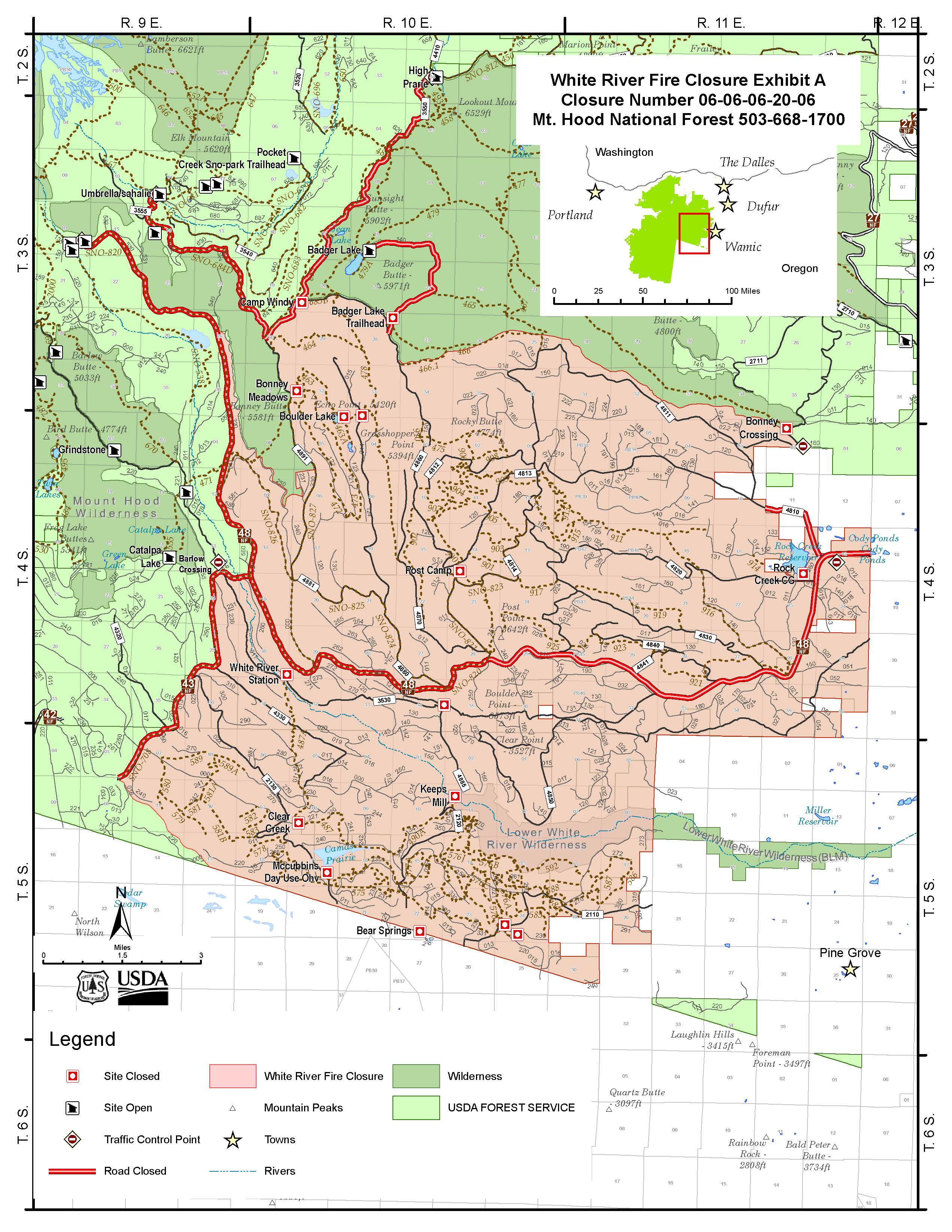
Barlow and Hood River Ranger District Fire Closure
Forest Order No. 06-06-06-20-06 - See below for official Closure Order and map
This closure includes all National Forest System lands, roads and trails administered by the Mount Hood National Forest, Barlow and Hood River Ranger Districts as depicted in Exhibit “A” within the following area:
Forest Service Road 3550 at the intersection of 4410 and 4420 south to Camp Windy then continues on Forest Road 3550 from Bennett Pass Snopark southeast to the junction with 4891.
All land, roads and trails east and southeast of the Badger Creek Wilderness and north of Forest Road 48 are closed beginning at the junction of Forest Road 48 and Highway 35.
All National Forest Lands south of the Badger Creek Wilderness to its southeast corner across from Bonney Crossing Campground are closed.
This closure extends south of Forest Road 48 at its junction with Forest Road 43 and extends to Highway 26 and State Highway 216.
The closure follows the southern and eastern end of the closure follow the forest boundary after State Highway 216 reaches the forest boundary in T5S, R9E, Section 13.
This closure affects the following trails:
- Crane Creek
- Crane Prairie
- Boulder Lake
- Forest Creek
- Hidden Meadows
- Bonney Meadows
- Threemile
- Camas
- Rimrock
- All of Rock Creek OHV Area
- All of McCubbins Gulch OHV Area
This closure affects the following recreation sites:
White River Station
Forest Creek
Keeps Mill
Boulder Lake
Little Boulder Lake
Post Camp
Camp Windy
Bonney Meadows
Bonney Crossing
Post Point OHV Staging Area
Gate Creek OHV Staging Area
Barlow Crossing
Rock Creek Day Use and Boat Launch
This closure affects the following campgrounds:
Rock Creek Campground
Clear Creek Campground
McCubbins Gulch Campground
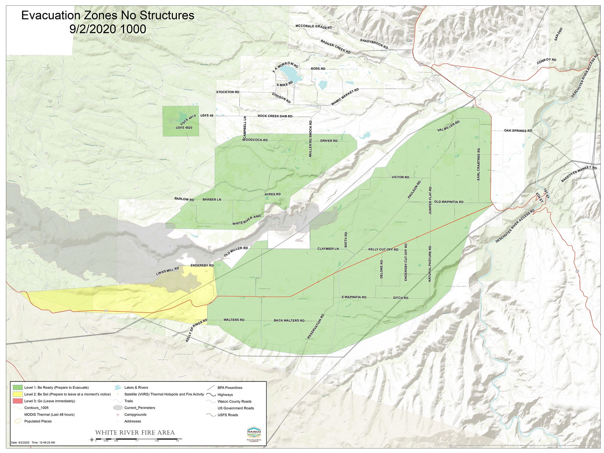
Updated Evacuation Levels Wasco County Sheriff Pine Grove now Level 2
Related Incident:
Publication Type: Announcement
White River Fire Update 29
NEW EVACUATION LEVELS
Firefighters made great progress on the hotspot in the northwest quadrant right above Pine Hollow. As per Sheriff Magill directions Evacuation level will be lowered and lifted in certain areas. There are no remaining level 3 areas. Please use caution when transiting the area due to Fire Teams still actively fighting fires in the area.
White River Fire Evacuation Area Updates are as follows:
Level 2 GET READY: for Pine Grove from the area east from Bear Springs Ranger Station along Hwy 216 through Pine Grove to the intersection of Endersby Rd and 216, also included are all of Endersby Rd, Linns Mill Rd and Kelly Springs Rd has been lowered to Level 2 GET READY.
Level 1 GET READY: All residences east side of Endersby Rd and East Side of Kelly Springs Rd to Hwy 197 have been lowered to Level 1 Get Ready.
LEVEL 1 GET SET: for the area from Woodcock Rd to Driver Rd to White River Crossing to include Muller Rd, Smock Rd, Ayres Rd, Barber Lane and Barlow Rd have been lowered to LEVEL 1 GET READY.
The LEVEL 1 GET READY: evacuation has been lifted for Pine Hollow, Wamic, Maupin and east side of Hwy 197 to include Oak Springs Rd and Old Wanpinita Rd have been lifted.
Sportsman’s Park remains at LEVEL 1 GET READY.
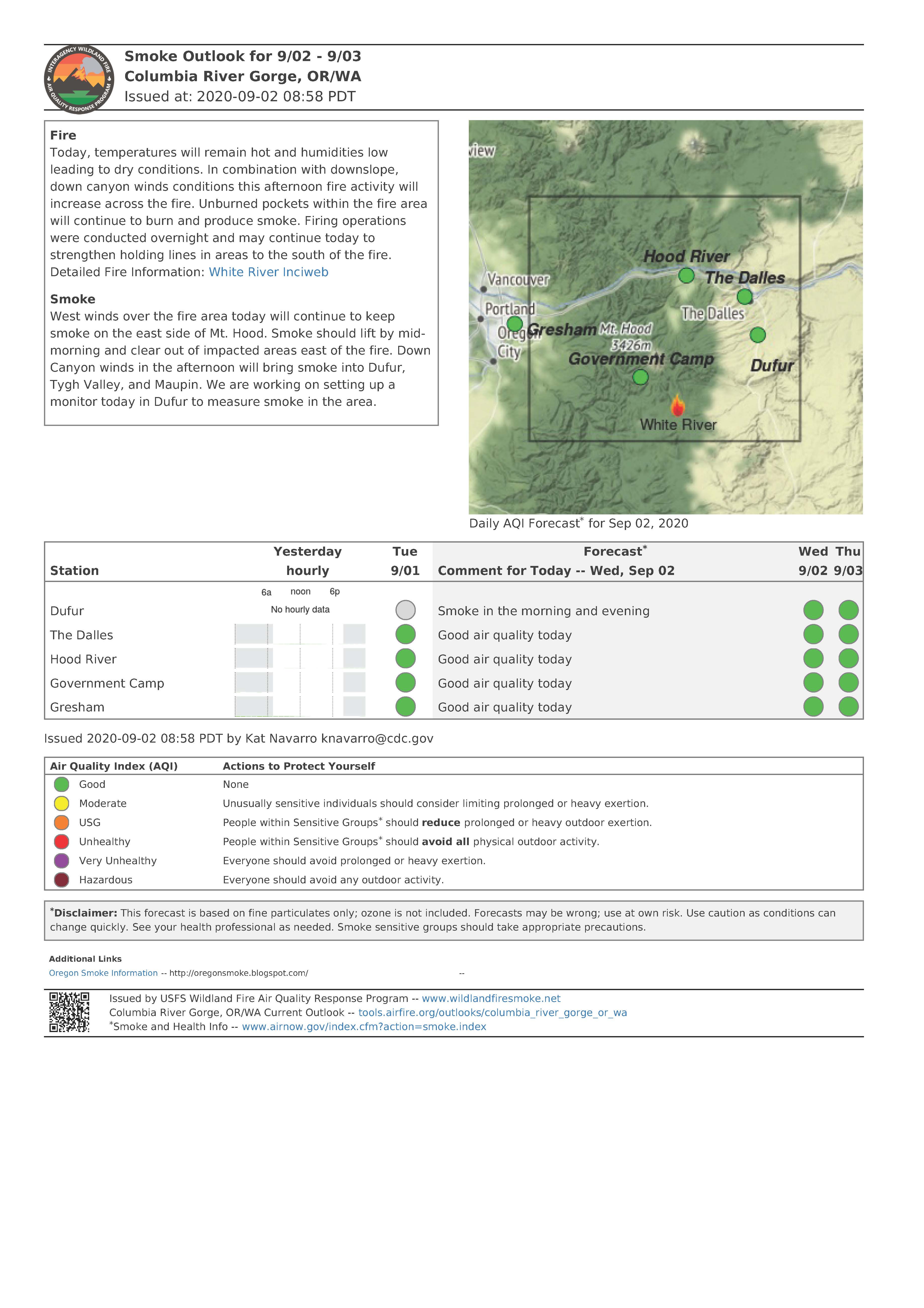
Smoke Report for Wednesday September 2 2020
Related Incident:
Publication Type: News
With west winds predicted for the fire area today, smoke should continue to move east and not impact communities along Highway 197.
View the complete report here:- https://fires.airfire.org/outlooks/columbia_river_gorge_or_wa
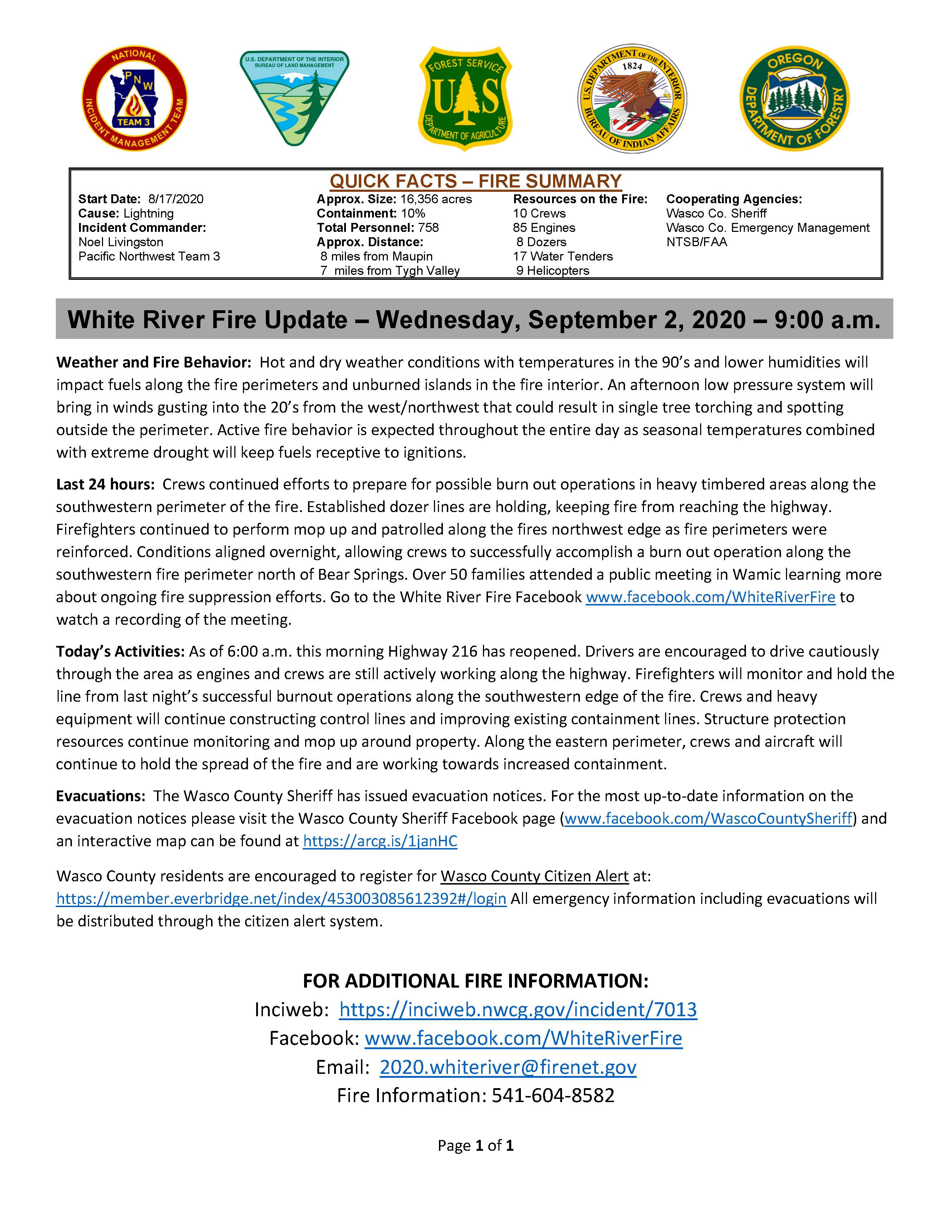
Daily Update for Wednesday September 2 2020
Related Incident:
Publication Type: News
Quick Facts - Fire Summary
Start Date: 8/17/2020
Cause: Lightning
Incident Commander: Noel Livingston, Pacific Northwest Team 3
Approximate Size: 16,356 acres
Containment: 10%
Total Personnel: 758
Approximate Distance: 8 miles from Maupin/7 miles from Tygh Valley
Resources on the Fire:
10 crews
85 engines
8 dozers
17 water tenders
9 helicopters
Cooperating Agencies:
Wasco County Sheriff
Wasco County Emergency Management
NTSB/FAA
Weather and Fire Behavior: Hot and dry weather conditions with temperatures in the 90’s and lower humidities will impact fuels along the fire perimeters and unburned islands in the fire interior. An afternoon low pressure system will bring in winds gusting into the 20’s from the west/northwest that could result in single tree torching and spotting outside the perimeter. Active fire behavior is expected throughout the entire day as seasonal temperatures combined with extreme drought will keep fuels receptive to ignitions.
Last 24 hours: Crews continued efforts to prepare for possible burn out operations in heavy timbered areas along the southwestern perimeter of the fire. Established dozer lines are holding, keeping fire from reaching the highway. Firefighters continued to perform mop up and patrolled along the fires northwest edge as fire perimeters were reinforced. Conditions aligned overnight, allowing crews to successfully accomplish a burn out operation along the southwestern fire perimeter north of Bear Springs. Over 50 families attended a public meeting in Wamic learning more about ongoing fire suppression efforts. Go to the White River Fire Facebook www.facebook.com/WhiteRiverFire to watch a recording of the meeting.
Today’s Activities: As of 6:00 a.m. this morning Highway 216 has reopened. Drivers are encouraged to drive cautiously through the area as engines and crews are still actively working along the highway. Firefighters will monitor and hold the line from last night’s successful burnout operations along the southwestern edge of the fire. Crews and heavy equipment will continue constructing control lines and improving existing containment lines. Structure protection resources continue monitoring and mop up around property. Along the eastern perimeter, crews and aircraft will continue to hold the spread of the fire and are working towards increased containment.
Evacuations: The Wasco County Sheriff has issued evacuation notices. For the most up-to-date information on the evacuation notices please visit the Wasco County Sheriff Facebook page (www.facebook.com/WascoCountySheriff) and an interactive map can be found at https://arcg.is/1janHC
Wasco County residents are encouraged to register for Wasco County Citizen Alert at: https://member.everbridge.net/index/453003085612392#/login All emergency information including evacuations will be distributed through the citizen alert system.
FOR ADDITIONAL FIRE INFORMATION:
Inciweb: https://inciweb.nwcg.gov/incident/7013
Facebook: www.facebook.com/WhiteRiverFire
Email: 2020.whiteriver@firenet.gov
Fire Information: 541-604-8582
Burn out operation north of Bear Springs
Related Incident:
Publication Type: Announcement
NOTICE: Firefighters intend to implement a burn operation late afternoon today (Tuesday, Sept 1) and into the evening as conditions allow.
The burn out will occur north of Bear Springs on the southwest portion of the White River Fire and is expected to create increased smoke in the area.
Success of this burn will be a key factor in downgrading of the existing Level 3 evacuation status as soon as safety allows.
Smoke Report for Tuesday September 1 2020
Related Incident:
Publication Type: News
"West winds over the fire area today will keep smoke on the east side of Mt. Hood." See below for today's smoke outlook
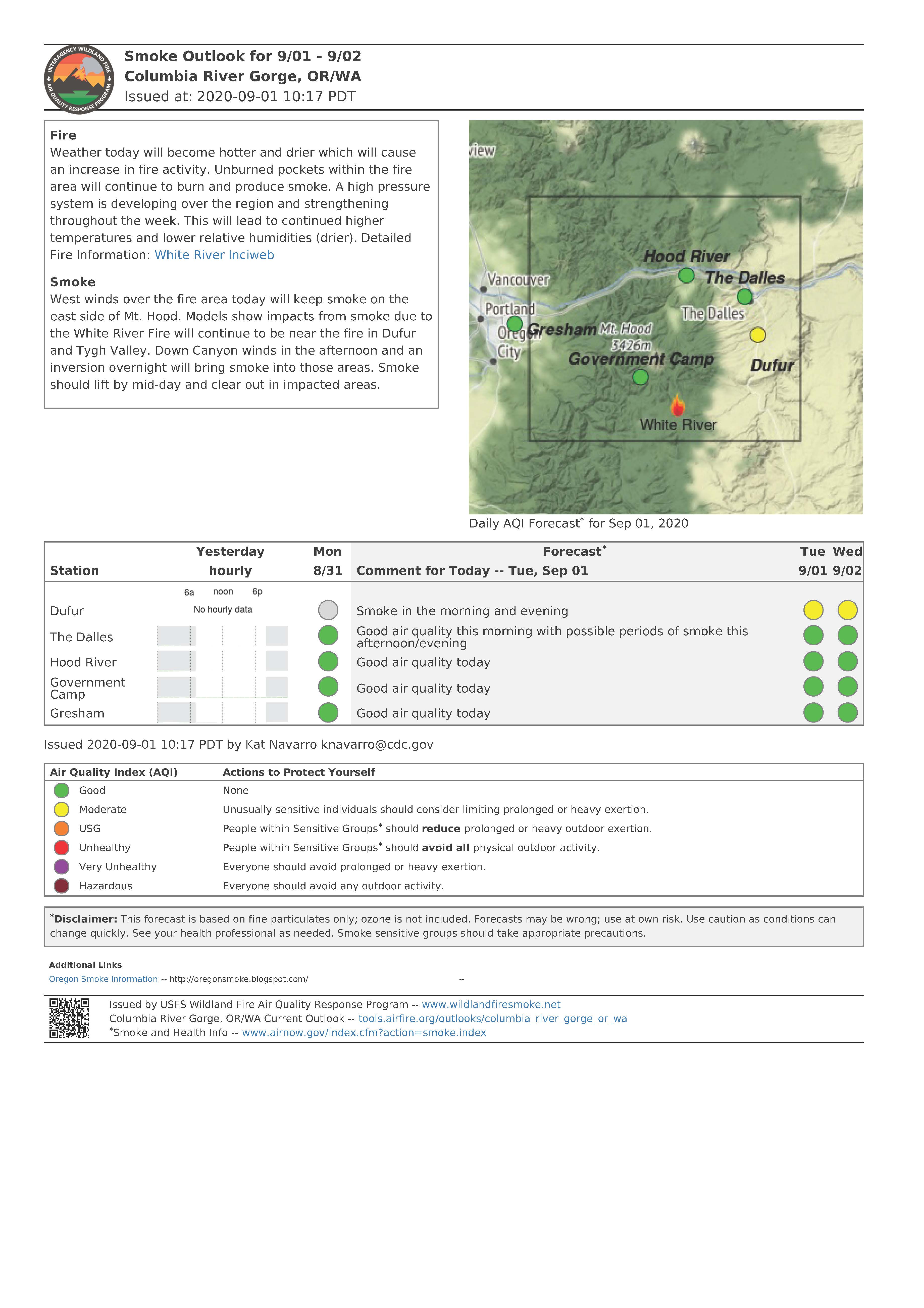
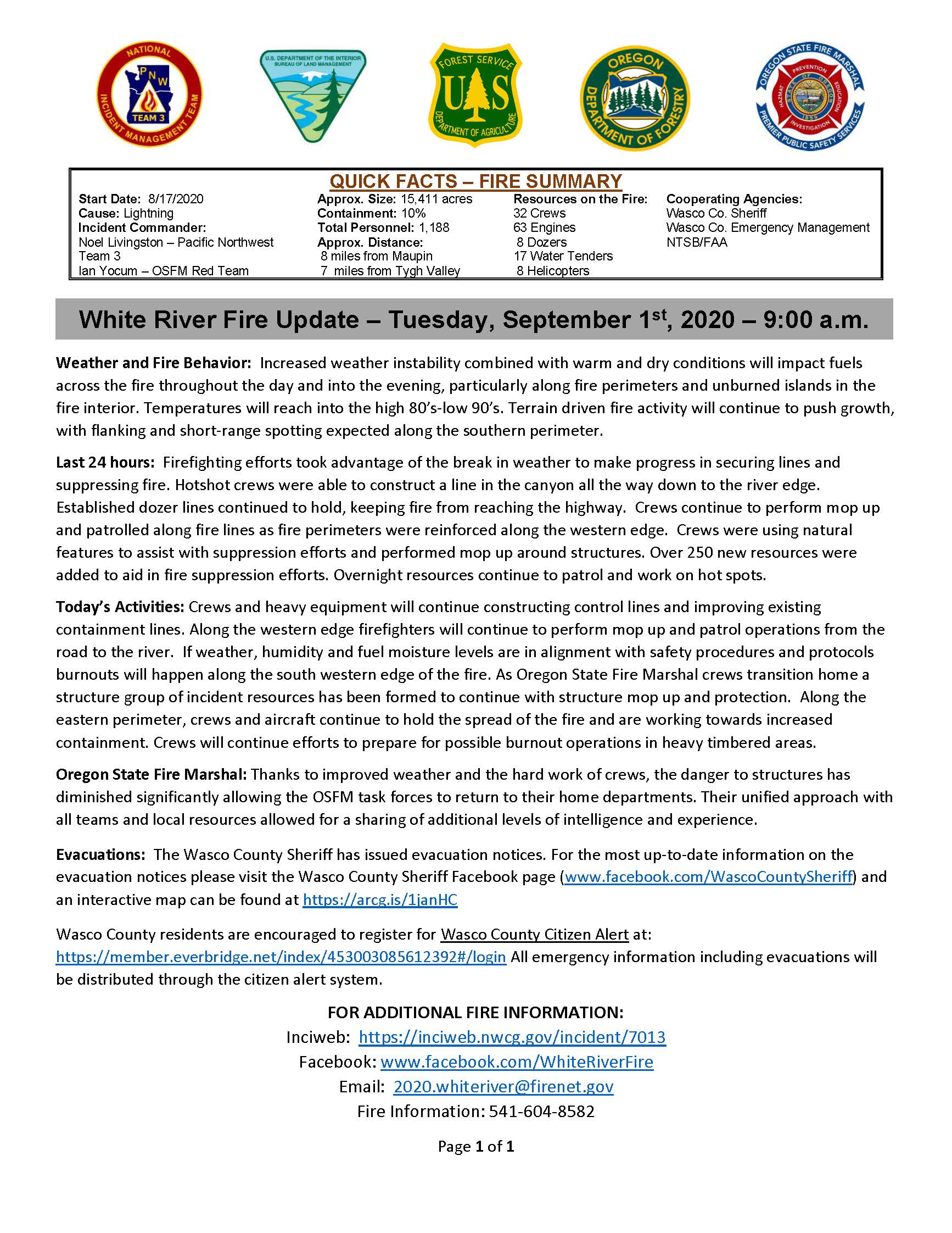
Daily Update for September 1 2020
Related Incident:
Publication Type: News
Quick Facts - Fire Summary
Start Date: 8/17/2020
Cause: Lightning
Incident Commander: Noel Livingston, Pacific Northwest Team 3
Approximate Size: 15,411 acres
Containment: 10%
Total Personnel: 1,188
Approximate Distance: 8 miles from Maupin/7 miles from Tygh Valley
Resources on the Fire:
32 crews
63 engines
8 dozers
17 water tenders 8
helicopters
Cooperating Agencies:
Wasco County Sheriff
Wasco County Emergency Management
NTSB/FAA
Weather and Fire Behavior: Increased weather instability combined with warm and dry conditions will impact fuels across the fire throughout the day and into the evening, particularly along fire perimeters and unburned islands in the fire interior. Temperatures will reach into the high 80’s-low 90’s. Terrain driven fire activity will continue to push growth, with flanking and short-range spotting expected along the southern perimeter.
Last 24 hours: Firefighting efforts took advantage of the break in weather to make progress in securing lines and suppressing fire. Hotshot crews were able to construct a line in the canyon all the way down to the river edge. Established dozer lines continued to hold, keeping fire from reaching the highway. Crews continue to perform mop up and patrolled along fire lines as fire perimeters were reinforced along the western edge. Crews were using natural features to assist with suppression efforts and performed mop up around structures. Over 250 new resources were added to aid in fire suppression efforts. Overnight resources continue to patrol and work on hot spots.
Today’s Activities: Crews and heavy equipment will continue constructing control lines and improving existing containment lines. Along the western edge firefighters will continue to perform mop up and patrol operations from the road to the river. If weather, humidity and fuel moisture levels are in alignment with safety procedures and protocols burnouts will happen along the south western edge of the fire. As Oregon State Fire Marshal crews transition home a structure group of incident resources has been formed to continue with structure mop up and protection. Along the eastern perimeter, crews and aircraft continue to hold the spread of the fire and are working towards increased containment. Crews will continue efforts to prepare for possible burnout operations in heavy timbered areas.
Oregon State Fire Marshal: Thanks to improved weather and the hard work of crews, the danger to structures has diminished significantly allowing the OSFM task forces to return to their home departments. Their unified approach with all teams and local resources allowed for a sharing of additional levels of intelligence and experience.
Evacuations: The Wasco County Sheriff has issued evacuation notices. For the most up-to-date information on the evacuation notices please visit the Wasco County Sheriff Facebook page (www.facebook.com/WascoCountySheriff) and an interactive map can be found at https://arcg.is/1janHC
Wasco County residents are encouraged to register for Wasco County Citizen Alert at: https://member.everbridge.net/index/453003085612392#/login All emergency information including evacuations will be distributed through the citizen alert system.
FOR ADDITIONAL FIRE INFORMATION:
Inciweb: https://inciweb.nwcg.gov/incident/7013
Facebook: www.facebook.com/WhiteRiverFire
Email: 2020.whiteriver@firenet.gov
Fire Information: 541-604-8582
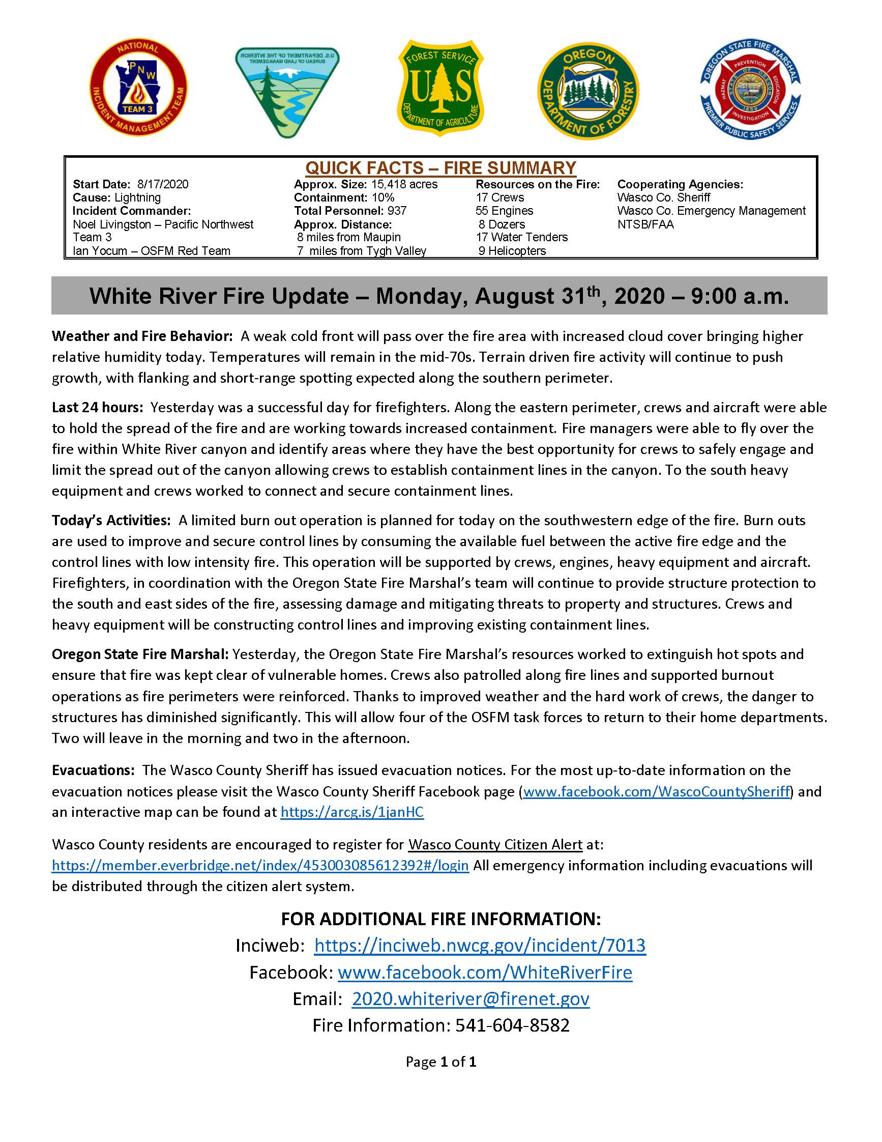
Daily Update for August 31 2020
Related Incident:
Publication Type: News
Quick Facts - Fire Summary
Start Date: 8/17/2020
Cause: Lightning
Incident Commander: Noel Livingston, Pacific Northwest Team 3 and Ian Yocum, Office of State Fire Marshal Red Team
Approximate Size: 15,418 acres
Containment: 10%
Total Personnel: 937
Approximate Distance: 8 miles from Maupin/7 miles from Tygh Valley
Resources on the Fire:
17 crews
55 engines
8 dozers
17 water tenders
9 helicopters
Cooperating Agencies:
Wasco County Sheriff
Wasco County Emergency Management
NTSB/FAA
Weather and Fire Behavior: A weak cold front will pass over the fire area with increased cloud cover bringing higher relative humidity today. Temperatures will remain in the mid-70s. Terrain driven fire activity will continue to push growth, with flanking and short-range spotting expected along the southern perimeter.
Last 24 hours: Yesterday was a successful day for firefighters. Along the eastern perimeter, crews and aircraft were able to hold the spread of the fire and are working towards increased containment. Fire managers were able to fly over the fire within White River canyon and identify areas where they have the best opportunity for crews to safely engage and limit the spread out of the canyon allowing crews to establish containment lines in the canyon. To the south heavy equipment and crews worked to connect and secure containment lines.
Today’s Activities: A limited burn out operation is planned for today on the southwestern edge of the fire. Burn outs are used to improve and secure control lines by consuming the available fuel between the active fire edge and the control lines with low intensity fire. This operation will be supported by crews, engines, heavy equipment and aircraft. Firefighters, in coordination with the Oregon State Fire Marshal’s team will continue to provide structure protection to the south and east sides of the fire, assessing damage and mitigating threats to property and structures. Crews and heavy equipment will be constructing control lines and improving existing containment lines.
Oregon State Fire Marshal: Yesterday, the Oregon State Fire Marshal’s resources worked to extinguish hot spots and ensure that fire was kept clear of vulnerable homes. Crews also patrolled along fire lines and supported burnout operations as fire perimeters were reinforced. Thanks to improved weather and the hard work of crews, the danger to structures has diminished significantly. This will allow four of the OSFM task forces to return to their home departments. Two will leave in the morning and two in the afternoon.
Evacuations: The Wasco County Sheriff has issued evacuation notices. For the most up-to-date information on the evacuation notices please visit the Wasco County Sheriff Facebook page (www.facebook.com/WascoCountySheriff) and an interactive map can be found at https://arcg.is/1janHC
Wasco County residents are encouraged to register for Wasco County Citizen Alert at: https://member.everbridge.net/index/453003085612392#/login All emergency information including evacuations will be distributed through the citizen alert system.
FOR ADDITIONAL FIRE INFORMATION:
Inciweb: https://inciweb.nwcg.gov/incident/7013
Facebook: www.facebook.com/WhiteRiverFire
Email: 2020.whiteriver@firenet.gov
Fire Information: 541-604-8582
LIVE Update Tonight Sunday August 30th at 430 pm
Related Incident:
Publication Type: Announcement
Incident Commander Trainee Johnson advised "today's conditions will be more favorable for firefighting" during our morning video briefing. Tune in to www.facebook.com/WhiteRiverFire at 4:30 p.m. today (August 30th) for a LIVE update from fire personnel and cooperating agencies. You do not need a Facebook account to participate.
We hope to see you there!