
Level 1 2 Notifications Issued for Deschutes and Jefferson Counties
Related Incident:
Publication Type: Announcement
08/19/20 Joint Release by Deschutes and Jefferson County Sheriffs' Office
Due to fire activity involving the Green Ridge Fire, the Deschutes and Jefferson County Sheriffs' Offices have issued the following evacuation notices:
This decision was made after consultation with fire managers and authorized by Sheriffs L. Shane Nelson and Jim Adkins. We will continue to work with fire managers to ensure public safety and prevent conflicts between citizens and fire operations. We appreciate the cooperation and understanding of residents.
Green Ridge Fire Update August 19
Related Incident:
Publication Type: News
Jefferson County, Oregon – The Green Ridge fire started on August 16 approximately 12 miles northwest of Sisters, Oregon. The Central Oregon Fire Management Services Team (COFMS), a local Type 3 Team, has been managing initial attack operations since the fire began. The fire continues to burn in mixed conifers and sagebrush. High temperatures and afternoon winds yesterday caused spotting across the eastern edge of the fire, and the fire grew to approximately 1,013 acres.
At 6:00 a.m. today, an Interagency Incident Management Team (NW Team 10) from the Pacific Northwest (Alan Lawson, Incident Commander) assumed management of the fire. Fire operations will focus on scouting for line locations and begin construction of direct and indirect fire line. Suppression priorities include stopping the spread of the fire into private timberland to the east and establishing and holding containment lines on the west where the fire has backed down into the Metolius Basin. More than 170 firefighting personnel are assigned to the Green Ridge Fire. Challenges remain high temperatures and low relative humidity, afternoon winds, and steep slopes on the western edge of the fire.
Three helicopters are assigned to the Green Ridge Fire. With limited flight time each day, these resources are used to support ground resources during the most critical time of the day when the fire is most active. A temporary flight restriction (TFR) is in place over the Green Ridge Fire area, restricting public access for aircraft including drones. Any time a drone is sighted within the TFR, air operations are grounded.
Our highest priority is the safety of the public and all wildland fire personnel. In coordination with local partners, state and federal fire agencies, the Wildland Fire Response Plan (WFRP) was developed to help protect firefighters and the public during the COVID-19 pandemic. To keep firefighters and communities healthy and safe during the Green Ridge Fire, all fire personnel are expected to follow recommendations from the Centers for Disease Control and Prevention (CDC). This includes limiting public access to the Incident Command Post (ICP) at Sisters Middle School. While COVID-19 circumstances are rapidly evolving, and federal agency guidance continues to adapt with the situation, NW Team 10 is prepared for wildland fire activity during this time.
The Deschutes National Forest is establishing area and road closures for the Green Ridge Fire today and a map and description of the closure area will be posted to Inciweb as soon as it is available.
Lion Creek Trail Closure order lifted
Related Incident:
Publication Type: Closures
The Lion Creek Trail #25 Closure order expires 10/23/2020 and will not be renewed. No closures are in effect on the Lion Creek Fire at this time. Users are reminded that multiple safety hazards exist in burned areas. Read Traveling and Recreating in a Burned Area (pdf) for more information.
Lion Creek Trail 25 Closure Order
Related Incident:
Publication Type: Closures
LION CREEK TRAIL #25 CLOSURE
Pursuant to 16 U.S.C. § 551, and 36 C.F.R. §§ 26l.50(b) the following restriction is in effect on the Swan Lake Ranger District on the Flathead National Forest, Lake County, Montana.
PROHIBITION 36 C.F.R. § 261.SS(a) -Being on the trail.
PURPOSE
This restriction is for public safety in the Lion Creek fire burn area on trail #25. The fire burned over approximately .5 mile of trail creating the potential for hazards.
AREA CLOSED TO HIKING
Lion Creek Trail# 25 starting at mile 5.3 through the burned section of the trail 5.7 mile depicted on the map attached as Exhibit A and herby incorporated into this Order.
IMPLEMENTATION
This order will be in effect from October 1, 2020, to October 23, 2020.
EXEMPTIONS
Pursuant to 36 C.F.R. §261.50(e), the following are exempt from this Order:
-
Persons with a special use authorization or other Forest Service authorization specifically exempting them from the effect of this Order. 36 C.F.R. § 26l.50(e)(l).
-
Any Federal, State, or local officer, or member of an organized rescue or fire fighting force in the performance of an official duty. 36 C.F.R. § 261.50(e)(4)
PENALTY
Violation of these prohibitions is punishable by a fine of not more than $5,000 for an individual or $10,000 for an organization, or imprisonment for not more than 6 months, or both (16 U.S.C. § 551 and 18 U.S.C. §§ 3559, 3571, and 3581).
INFORMATION
Further information regarding this order may be obtained at the Swan Lake Ranger District office in Bigfork, MT, (406) 387-7500, or at the Flathead National Forest Supervisor's Office located at 650 Wolfpack Way,
Kalispell, MT, 59901, (406) 758-5208.
Done at Kalispell, Montana this 1st day of October 2020.
By: Kurt Steele
Forest Supervisor
Order D01145S20 Area Closure in the Lion Creek Area Extension
Related Incident:
Publication Type: Closures
FLATHEAD NATIONAL FOREST
650 Wolfpack Way
Kalispell, MT 59901
Forest Supervisor’s Order
AREA CLOSURE IN THE LION CREEK AREA
PROHIBITION
Pursuant to 16 U.S.C. § 551, and 36 C.F.R. §§ 261.52(e), the following restriction is in effect on the Swan Lake Ranger District on the Flathead National Forest, Flathead County, Montana.
1. Going into or being upon an area as described below. 36 C.F.R. § 261.52(e).
PURPOSE
This restriction is for public safety in the Lion Creek area and associated road and trails. This area sees recreation use by dispersed campers, Outfitters and Guides, and trail users. This order is necessary to keep the public out of the area and safely away from the Lion Creek Fire currently being suppressed by ground and air support.
AREA CLOSED TO PUBLIC USE
For the purpose of this order, it is prohibited to be on any National Forest System Lands as depicated on the map attached as Exhibit A and herby incorporated into this order.
IMPLEMENTATION
This order will be in effect from August 28, 2020, to October 1, 2020.
EXEMPTIONS
Pursuant to 36 C.F.R. §261.50(e), the following are exempt from this Order:
1. Any Federal, State, or local officer, or member of an organized rescue or fire fighting force in the performance of an official duty. 36 C.F.R. § 261.50(e)(4)
PENALTY
Violation of these prohibitions is punishable by a fine of not more than $5,000 for an individual or $10,000 for an organization, or imprisonment for not more than 6 months, or both (16 U.S.C. § 551 and 18 U.S.C. §§ 3559, 3571, and 3581).
INFORMATION
Further information regarding this order may be obtained at the Swan Lake Ranger District office located at 200 Ranger Station Rd. Bigfork, MT, 59911, (406) 837-7500, or at the Flathead National Forest Supervisor’s Office located at 650 Wolfpack Way, Kalispell, MT, 59901, (406) 758-5208.
Done at Kalispell, Montana this 28th day of August 2020.
By: Kurt Steele, Forest Supervisor
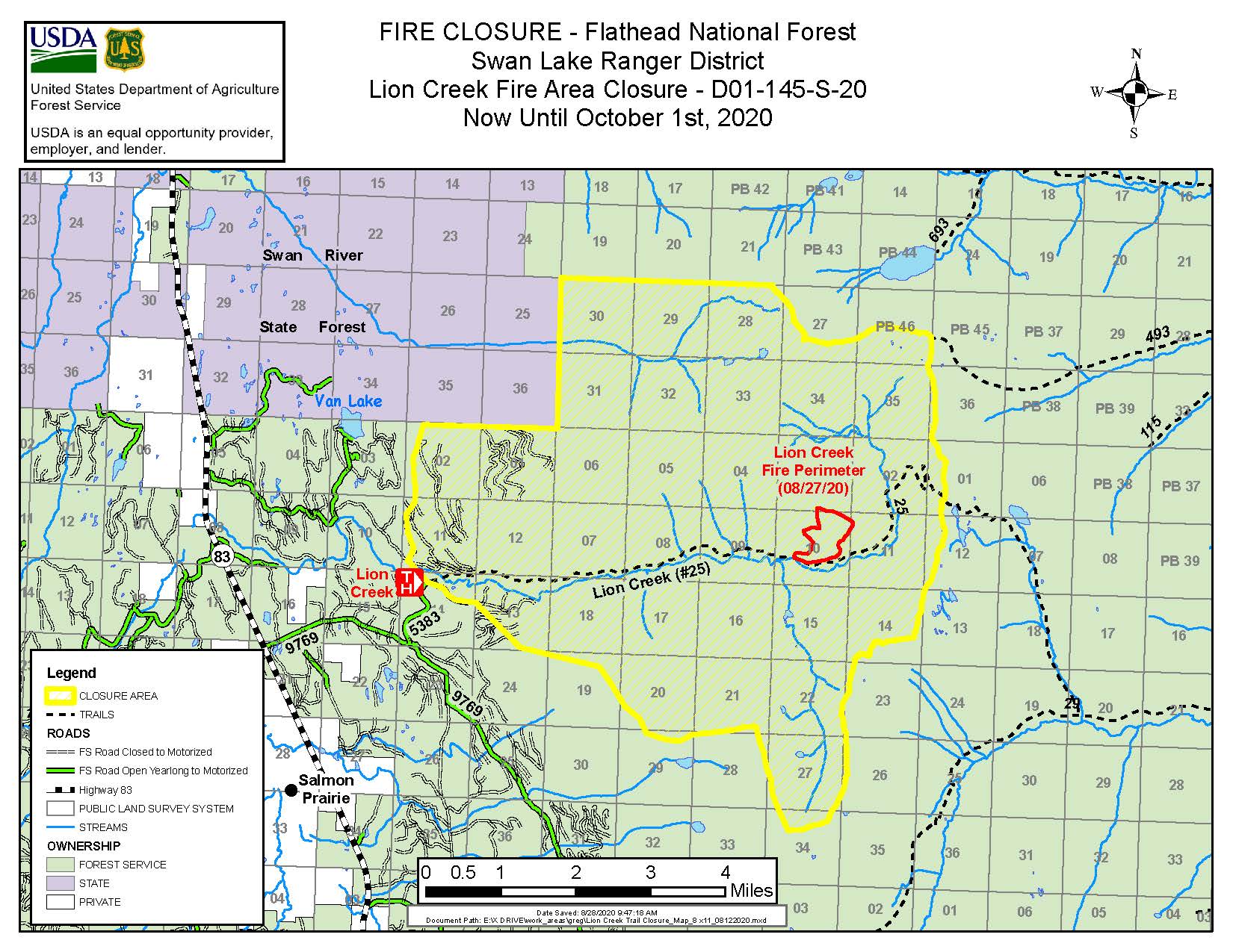
Order D01143S20 Area Closure in the Lion Creek Area
Related Incident:
Publication Type: Closures
The area shown on this map, including all trails and roads within the area are closed in order to keep the public safely away from the Lion Creek area and facilitate fire suppression efforts by ground and air.

Firefighters attacking Lion Creek Fire in remote Swan Range
Related Incident:
Publication Type: News
Fire prompts area closure for public safety
Kalispell, MT August 12, 2020 – Flathead National Forest firefighters are working on suppressing a fire in a remote area of the Swan Mountain Range.
The Lion Creek Fire was reported yesterday, August 11, burning in heavy fuels on steep slopes. Fire managers have not yet determined the cause.
The fire is burning approximately one mile outside the Bob Marshall Wilderness and four miles from other land ownership (DNRC).
At 10:50 am yesterday, a Montana Department of Natural Resources and Conservation helicopter spotted the fire on its way to another fire assignment. The Forest immediately sent ground crews and helicopters for initial attack. Due to its remote location, it took ground crews approximately three hours to hike to the fire. No roads access the area. Once there, firefighters were only able to engage the fire in a limited manner due to falling snags and steep, rugged terrain. Helicopter resources were able to moderate fire spread, accessing a nearby lake for water and quick turnaround times.
The fire was measured last night at 75 acres. The area is known for the development of nighttime thermal belt activity due to its location and elevation. Some nighttime burning activity is expected. Initial attack resources are working on securing the south flank of the fire and maintaining access on the Lion Creek Trail to allow backcountry users to leave the area. Today, the Forest is using two additional hand crews, several advanced fallers and two helicopters to aid in suppression efforts. The Lion Creek Trail area is closed, and nearby Forest Service roads are also closed as they have connector trails that come near the fire.
People in the Swan Valley may see some smoke, though right now fire managers expect that much of the smoke will blow east into the Bob Marshall Wilderness due to wind patterns.
The area is not heavily visited, but visitors to Van Lake (7 miles away) should be aware that Lion Creek Trail #25 is closed. People can map the fire location using the latitude/longitude 47 40.644, -113 38.274.
The Forest expects that this fire may require a longer duration response due to its location and the difficulties it presents with access, steep terrain, falling snags, and heavy forest fuels.
This year, due to Covid-19, the Forest Service is using aggressive initial attack, supported by available air tankers and helicopters wherever possible to extinguish wildfires quickly and minimize the need to bring large numbers of firefighters together. Fire managers understand the potential complications wildfire smoke may cause for COVID-19 patients and others with respiratory issues. The Forest will work closely with communities to assist with forecasting and preparation for wildfire smoke.
So far this summer, the Flathead National Forest has responded to 16 fires on Forest Service managed lands. This is the only one currently burning and is the largest fire in the Flathead National Forest so far this year.
The Forest will send another update if firefighting tactics or fire behavior changes significantly.
Pacific Southwest Region Aviation Information Bulletin
Related Incident:
Publication Type: News
We are in the height of the 2020 Western fire season and we have been reminded that the wildland fire environment is dangerous whether you are on the ground or in the air. Along with the increase in fire activity, there has been an increase in close calls, serious accidents, injuries, and fatalities. Please honor those that have fallen, most recently our aviators, by actively managing risk. It is now late August and long-term fatigue is setting in, which exacerbates the complexity of a fire season made even more difficult by COVID-19.
We ask you to take a tactical pause at some point on Wednesday, September 2ND to discuss current risks to which you are exposed. The timing and length of this tactical pause is at your discretion. During this time stop, think, and talk about how you assess and mitigate risk. Ask yourself, your coworkers, or your crew what, if anything, is different from your previous experience and how are you dealing with it?
What is concerning you specifically when it comes to your safety and those you work with or lead? What might you be missing? It is all too easy to be task oriented so take this opportunity to discuss some simple reminders or measures you can take to reduce your exposure to the inherent hazards of our occupation or COVID-19, which can reduce the probability of the next accident or illness. Use references such as the Incident Response Pocket Guide (IRPG) to aid you in your discussions.
The latest interagency wildland fire COVID-19 information can be found on the Medical and Public Health Advisory Team (MPHAT) webpage. The value of this tactical pause will be in the discussions you engage in so make it count. We also recommend that you review and discuss Planning for Medical Emergencies (page #2) and the Medical Incident Report (page #118-119), also referred to as the "8-Line", in your IRPG. Reviewing and discussing these job aids will better prepare you to respond to an accident or medical emergency if one does occur.
Finally, NMAC wants to be clear that we care about the health and welfare of our responders. We are asking you to take this time to discuss risk management and do everything possible to ensure you return home safely at the end of each shift and each fire assignment.
Bureau of Land Management Reopens Trails and Campground
Related Incident:
Publication Type: News
Bureau of Land Management reopens trail, campground as fires subside
SUSANVILLE, Calif. – The Bureau of Land Management’s Eagle Lake Field Office has reopened the Dodge Reservoir Campground and the Bizz Johnson National Recreation Trail in Lassen County, as dangers from two wildfires has been reduced.
The BLM temporarily closed the sites in late August, when the W-5 Cold Springs wildfire moved within a mile of the campground, and there was potential for the Sheep Fire to spread into the trail corridor. While fire crews continue to work on both incidents, active fire is now far from each of the recreation sites.
Dodge Reservoir Campground is about 60 miles northeast of Susanville and offers a remote camping experience and fishing in good water years. Information and directions are available at www.blm.gov/visit/dodge-reservoir-campground.
The reopened section of the Bizz Johnson Trail extends from Susanville west for seven miles through the scenic Susan River Canyon to the Devil’s Corral Trailhead along California State Highway 36. One section of the Bizz Johnson Trail from the Devil’s Corral Trailhead west to the Goumaz Campground remains closed to protect public safety while damages from this summer’s Hog Fire are repaired. Trail information and directions are available at www.blm.gov/visit/bizz-johnson.
The BLM reminds public land visitors that campfire restrictions are now in place in northeast California. All campfires are prohibited, including in developed campgrounds and recreation sites. Portable stoves and lanterns using pressurized, liquid, or jellied fuel are allowed. A valid California campfire permit is required, and can be obtained free at www.readyforwildfire.org.
Information on BLM public land fire restrictions is available at www.blm.gov/programs/public-safety-and-fire/fire-and-aviation/regional-info/california/fire-restrictions.
-BLM-
The BLM manages more than 245 million acres of public land located primarily in 12 Western states, including Alaska. The BLM also administers 700 million acres of sub-surface mineral estate throughout the nation. In fiscal year 2018, the diverse activities authorized on BLM-managed lands generated $105 billion in economic output across the country. This economic activity supported 471,000 jobs and contributed substantial revenue to the U.S. Treasury and state governments, mostly through royalties on minerals.
Eagle Lake Field Office, 2550 Riverside Drive, Susanville, CA 96130
Follow the BLM on Twitter, Facebook, and Flickr @BLMCA and @BLMCalifornia
Closure Order lifted adding to Labor Day recreation opportunities
Related Incident:
Publication Type: News
ALTURAS, Calif. —Labor Day Weekend has once again arrived, heralding to many their last chance to get out and enjoy all that nature provides. While outdoor recreation demand soars everywhere, firefighters are also grappling with the most acres burned on the Modoc National Forest since 1910.
Please do everything within your power to avoid starting another wildfire. Resources are already spread very thin.
Fire-safety restrictions remain in effect on all California national forests. Please only burn campfires in excepted recreation facilities listed along with other restrictions at https://www.fs.usda.gov/alerts/modoc/alerts-notices/?aid=58896.
Learn what else can be done to prepare for and prevent wildfires at https://www.readyforwildfire.org/prevent-wildfire/one-less-spark-campaign/.
The W-5 Cold Springs Fire Area Closure will be lifted at 12:01 a.m. on Friday, Sept. 4, 2020 opening Blue Lake and the southern end of the Warner Mountains again to recreation. Please be aware of hunters in the area and always plan to pack out everything you pack in.
Recreation conditions updates are available at https://www.fs.usda.gov/recmain/modoc/recreation or by calling 530-233-5811 and leaving a message for prompt reply.
###