
Horse Fire Arizona Update October 19 2020
Related Incident:
Publication Type: News
Virtual Community Meeting at 6:00 p.m. Monday, Facebook: https://www.facebook.com/PrescottNF/
Acres: 8968 acres Containment: 21% Resources: 256
Vegetation: Juniper, Chaparral and Timber
Start Date: Oct. 15, 2020: noon Cause: Human, Under Investigation
Origin Location: 7 Miles Northwest of Crown King; 18 miles south of Prescott, AZ on the Bradshaw Ranger District (T1N, R2W, S24)
Above Average Temperatures, Extreme Topography Impact the Horse Fire
Type 1 Incident Management Team Assumes Command with Additional Resources
Crown King, ARZ, Oct 19, 2020 – Three firefighting divisions are protecting the community of Crown King, Arizona from the Horse wildfire Monday by creating firebreaks, constructing fireline, and installing sprinkler systems from the center of the town to outward structures. Crown King is evacuated. Additional work occurred along the southwest fire perimeter where firefighters increased containment to 21 percent.
Most of the heat and active burning is occurring in the northeast perimeter to the west of FR 52 (Senator Highway). Crews are actively engaged along Senator Highway working to keep fire activity to the west of Senator Highway. Activity at Hooper Saddle continues to consume vegetation and slowly move south.
Due to severe drought, plants are dead or dry and make for good fire fuel. Access is limited by the steep terrain and dense vegetation, making it unsafe for firefighters to fight the fire directly at the edge. Therefore, the Horse Fire will burn within its footprint for a long duration until significant moisture consistently hits the area for longer durations.
The Horse Fire started on October 15, 2020 when there was no lightning; making it a human-caused fire that is under investigation. The Prescott National Forest had no burning operations or prescribed fires.
All roads leading into Crown King have been closed – Goodwin, Senator Highway at Palace Station, and County Road 59 from Cleator. Please avoid the area to allow emergency personnel access. Yavapai County Sheriff’s Office has issued a Code Red ‘Go’ for the communities of Crown King, Minnehaha, Horsethief Cabins and any private inholdings in and around the fire area. There are evacuations currently in effect. For information on the Code Red alerts issued you can visit the Sheriff’s Office Facebook page for updates or call (928) 771-3321 or to sign up for Code Red notifications visit Yavapai County Code Red Notification.
FAA issues Temp Flight Restrictions
Related Incident:
Publication Type: News
The Federal Aviation Administration has issued Temporary Flight Restrictions for the Horse Fire. Visit https://tfr.faa.gov/save_pages/detail_0_3743.html for more information
Horse Fire Arizona Update October 18 2020
Related Incident:
Publication Type: News
Horse Fire Actively Burning in Extreme Terrain
Type 1 Incident Management Team Assumes Command with Additional Resources
Acres: 8950 acres
Containment: 0%
Resources: 256
Vegetation: Juniper, Chaparral and Timber Start Date: Oct. 15, 2020: noon
Cause: Under Investigation
Origin Location: 7 Miles Northwest of Crown King; 18 miles south of Prescott, AZ on the Bradshaw
Ranger District (T1N, R2W, S24)
Crown King, ARZ –The Southwest Area Type 1 Incident Management Team assumes command of the Horse
Fire Sunday with additional firefighters and support equipment arriving in Crown King, Arizona.
The Horse Fire is actively burning northwest of Crown King and about 18 miles south of Prescott in
very remote areas of the Prescott National Forest. With brush as high as eight feet, dense
vegetation, steep terrain, and limited access options, firefighters cannot be placed directly in
front of the fire. Aircraft is and has been aggressively used since the fire began Thursday, for
full suppression.
Firefighters are working Sunday to creative protection of the communities of Crown King, Minnehaha,
Cleator Black Canyon City, Groom Creek, Ponderosa Park, Walker, Potato Patch, Pine Flat, Breezy
Pines, Lookout Mountain, Wilhoit, Wagoner, Walnut Grove, and Prescott.
Additionally, crews are working to safeguard critical infrastructure: communication towers (Towers
Mountain, Wildflower), APS Powerlines, Lookout Towers (Horsethief, Union and Spruce),
transportation systems, as roads and bridges.
All roads leading into Crown King have been closed – Goodwin, Senator Highway at Palace Station,
and County Road 59 from Cleator. Please avoid the area to allow emergency personnel access. Yavapai
County Sheriff’s Office has issued a Code Red ‘Go’ for the communities of Crown King, Minnehaha,
Horsethief Cabins and any private inholdings in and around the fire area. There are evacuations
currently in effect. For information on the Code Red alerts issued you can visit the Sheriff’s
Office Facebook page for updates or call (928) 771-3321 or to sign up for Code Red notifications
visit Yavapai County Code Red Notification.
The last fire recorded in the month of October within the Prescott National Forest was in 2007 at
only 630 acres; this is an unprecedented year for fire activity.
Horse Fire Update Oct 17 2020
Related Incident:
Publication Type: News
Horse Fire Information Phone 928-925-1111(updated since to (928) 235-2061)
Location: 7 Miles Northwest of Crown King; 18 miles south of Prescott, AZ on the Bradshaw Ranger District (T1N, R2W, S24)
Size: 8,458 acres
Start Date: October 15, 2020
Percent Contained: 0%
Vegetation: Juniper, Chaparral and Timber
Cause: Under Investigation
Prescott AZ, October 17, 2020 - The Horse Fire grew to 8,458 acres late yesterday afternoon.
Airtankers and helicopters continued working on efforts to slow the spread of the fire; firefighters worked on structure protection in and around the community of Crown King and Towers Mtn. The fire is in a remote section of the forest with steep, rugged terrain. Efforts were focused on the protection of the communities, and infrastructure that are being affected by the Horse fire.
Extreme fire behavior was observed over the fire making uphill runs throughout the day.
Closures: All roads leading into Crown King have been closed including-Jefferson St. at Goodwin, Senator Highway at Palace Station, County Road 59 from Cleator, and Wagoner at Hozoni.
Please avoid the area to allow suppression resources to travel safely to and throughout the incident.
A Forest Closure Order is in effect for the trails and roads in and around the Horse Fire area.
Yavapai County Sheriff’s Office has issued a Code Red ‘GO’ There are evacuations currently in effect for the communities of Crown King, Minnehaha, Horsethief Cabins and any private inholdings in and around the fire area.
For information on the Code Red alerts issued you can visit the
Sheriff’s Office Facebook page for updates or call (928) 771-3321 or to sign up for Code Red
notifications visit Yavapai County Code Red Notification.
People affected by the Horse Fire evacuation can call the American Red Cross to arrange for assistance: 800-842-7349
Resources: 1 - Air Attack, 3 – Air Tankers, 3 – Helicopter, 4 – Hotshot Crew, 3 – Type 2 IA Crew, 10 – Engines, Miscellaneous Overhead.
Weather: Maximum temperatures ranging from 80-82 degrees, minimum relative humidity 11-13%, Westerly winds are forecasted to develop by Saturday afternoon around 10 mph with gusts to 20 mph.
HORSE FIRE PUBLIC SAFETY CLOSURE
Related Incident:
Publication Type: Closures
Order Number: 03-09-03-21-271
UNITED STATES DEPARTMENT OF AGRICULTURE
U.S. FOREST SERVICE PRESCOTT NATIONAL FOREST BRADSHAW RANGER DISTRICT
HORSE FIRE PUBLIC SAFETY CLOSURE
PROHIBITIONS
Pursuant to 16 U.S.C. § 551 and 36 C.F.R. § 261.50(a) and (b), the following acts are prohibited
within the area described in this Order (the “Restricted Area”) and as depicted on the attached
map, hereby incorporated into this Order as Exhibit A, within the Verde Ranger District, Prescott National Forest, Yavapai County, Arizona.
1. Going into or being upon the Restricted Area. 36 C.F.R. § 261.53(e).
EXEMPTIONS
Pursuant to 36 C.F.R. § 261.50(e), the following persons are exempt from this Order:
1. Persons with a written Forest Service authorization specifically exempting them from the
effect of this Order.
2. Any Federal, State, or Local Officer, or member of an organized rescue or firefighting
resource in the performance of an official duty.
3. Residents, owners and lessees of private property within the Restricted Area are allowed
ingress and egress only to and from their properties.
RESTRICTED AREA
The Restricted Area consists of all National Forest System lands, roads, and trails within the
boundary starting at the intersection of National Forest System Road (NFSR) 94 and the National Forest (NF) boundary, proceeding south along the NF boundary for approximately 11 miles, then following the NF boundary east for approximately 6 miles, then south 2 miles, then east 12 miles, then north approximately 17 miles, then west 3 miles, to the intersection with County Road (CR) 177, then following west along CR 177 for approximately 7 miles to its intersection with NFSR 52,
then following NFSR 52 northwest 4 miles, to its intersection with NFSR 82, then following NFSR 82 south for approximately 3 miles to its intersection with NFSR 82A, then following NFSR 82A southwest to its intersection with NFSR 94, then following NFSR 94 northwest approximately 3 miles back to the point of beginning at its intersection with the NF
boundary.
Note: NFSR 94 is closed from NFSR 82A to the NF boundary. CR 177 is closed from the NF boundary to NFSR 52. NFSR 52 is closed from CR 177 to NFSR 82. NFSR 82 is closed from NFSR 52 to NFSR 82A.
NFSR 82A is closed from NFSR 82 to NFSR 94.
PURPOSE
To provide for public and fire fighter health and safety due to firefighting operations and fire
danger associated with the uncontrolled Horse Fire on the Prescott National Forest.
IMPLEMENTATION
1. This Order will be effective on October 16, 2020, at 6:00 p.m. and shall remain in effect
until 6:00 p.m. on November 30, 2020, or until rescinded, whichever occurs first.
2. A map identifying the Restricted Area is attached and made part of this Order as Exhibit A.
3. Any violation of this prohibition is punishable as a Class B misdemeanor by a fine of not more than $5,000 for individuals and $10,000 for organizations, or by imprisonment for not more than six (6) months, or both (see 16 U.S.C. § 551, 18 U.S.C. § 3571(b)(6), 18 U.S.C. § 3581(b)(7)).
4. Further information regarding this Order may be obtained at the Bradshaw Ranger District located in Prescott, Arizona, telephone number 928 443-8000, and at the Prescott National Forest
Supervisor’s Office in Chino Valley, telephone number 928 777-2200, and at
http://www.fs.usda.gov/prescott.
5. This Order supersedes any previous Orders prohibiting the same acts covered by this Order.
Done at Prescott, AZ, this 16th day of October, 2020.
Dale A. Deiter
Forest Supervisor
Prescott National Forest
Evacuation for Residents of Crown King Oct 16 at 850 AM
Related Incident:
Publication Type: Announcement
An evacuation has been issued by Yavapai County Sheriff's Office for Residents of Crown King due to the Horse Fire. An evacuation center had been established at Mayer High School in Spring Valley.
YCOEM encourages residents to register for Code RED through the Yavapai County Sheriff's Office. Please register if you have not already done so. Code RED is the emergency notification system used to notify residents of evacuations in their area. http://bit.ly/YavapaiCountyCODERED
Horse Fire Update
Related Incident:
Publication Type: News
Horse Fire Update – October 16, 2020
Horse Fire Information Phone 928-925-1111
Location: 7 Miles Northwest of Crown King; 18 miles south of Prescott, AZ on the Bradshaw Ranger District (T1N, R2W, S24)
Start Date: October 15, 2020
Size: 3,500 Acres
Percent Contained: 0%
Cause: Under Investigation
Vegetation: Juniper, Chaparral and Timber
Weather: Maximum temperatures ranging from 84-86 degrees, minimum relative humidity 8%-11, Morning northeast winds 6 to 10 mph with gusts to 15 mph becoming variable at 6 to 8 mph, afternoon winds will shift to the west to southwest around 8 to 10 mph.
The Horse Fire grew to 3,500 acres over the evening. Airtankers and helicopters were essential in slowing the spread of the fire as firefighters gained access. The fire is in a remote section of the forest with steep, rugged terrain. The strategy for the Horse fire is full suppression as crews continue to use aircraft to slow the rate of spread and scout for holding features to use as containment lines. The fire burned active all night and spotted just south of Minnehaha as of 8AM and has become well established and has become 100 acres in size.
All roads leading into Crown King have been closed – Goodwin, Senator Highway at Palace Station, and County Road 59 from Cleator. Please avoid the area to allow suppression resources to travel safely to and throughout the incident. A forest closure order can be expected for the trails and roads in and around the fire area.
Yavapai County Sheriff’s Office has issued a Code Red ‘Go’ for the communities of Crown King, Minnehaha, Horsethief Cabins and any private inholdings in and around the fire area. There are evacuations currently in effect. For information on the Code Red alerts issued you can visit the Sheriff’s Office Facebook page for updates or call (928) 771-3321 or to sign up for Code Red notifications visit Yavapai County Code Red Notification.
Resources: 1- Air Attack, 3 – Air Tankers, 3 – Helicopter, 4 – Hotshot Crew, 3 – Type 2 IA Crew, 10– Engines. Miscellaneous Overhead
For more information visit or call the following:
Fire Information: (928) 925-1111
Twitter: @PrescottNF
Facebook: https://www.facebook.com/PrescottNF/
Firefighters Respond to Smoke Report South of Prescott
Related Incident:
Publication Type: News
Firefighters Respond to Smoke Report South of Prescott
PRESCOTT, AZ – OCTOBER 15, 2020 - The Horse Fire was reported by Union Lookout shortly after 12:00 PM on Thursday, October 15th. The fire is burning through juniper and chaparral on the north side of Horse Mountain which is approximately 6 miles northwest of Crown King and 18 miles south of Prescott (T11N, R2W, S24). At 16:00, aircraft on scene mapped the fire at approximately 300 acres. Due to the fire’s remote location and rugged terrain, fire managers are currently relying on aircraft to suppress the fire.
As a precaution, Yavapai County Sheriff’s Office has issued a Code Red ‘SET’ for the community of Crown King. There are NO evacuations currently in effect. For information on the Code Red alerts issued you can visit the Sheriff’s Office Facebook page for updates or call (928) 771-3321.
Resources: 1 - Air Attack, 3 – Air Tankers, 3 – Helicopter, 1 – Hotshot Crew, 1 – Type 2 IA Crew, 3 – Engines.
Remember –Stage 1 Fire Restrictions are currently in effect on the Prescott National Forest.
The public can obtain additional information via the following:
Prescott NF Forest Website: http://www.fs.usda.gov/prescott/
Twitter: @PrescottNF
Facebook: https://www.facebook.com/PrescottNF/
Local Ranger Station: Bradshaw Ranger District (928) 443-8000
Additional Areas Reopen In Rocky Mountain National Park After East Troubles
Related Incident:
Publication Type: News
Rocky Mountain National Park News Release
December 22, 2020
For Immediate Release
Additional Areas Reopen In Rocky Mountain National Park After East Troublesome Fire Impacts Continue To Be Assessed
Today, Tuesday, December 22, additional areas reopened in Rocky Mountain National Park, as park staff continue to assess impacts from the East Troublesome Fire.
On the west side of the park, the North Inlet Trail reopened to Cascade Falls and will remain closed past the Falls. The Lower Tonahutu Trail, a short section of trail from the Kawuneeche Visitor Center to the North Inlet Trail, reopened as well.
On the east side of the park, the Moraine Park Road reopened to the Fern Lake Road winter turnaround. The Fern Lake Road, Fern Lake Trail and Cub Lake Trail remain closed.
The Bierstadt Trail system has reopened. The Bierstadt Trail can now be accessed from Bear Lake, from the Bierstadt Lake Trailhead, and from the Park & Ride area. The two sections of trail that drop into the Mill Creek Basin will remain closed.
The Upper Beaver Meadows Trail has reopened to the Moraine Park area. However, the Beaver Mountain Trail and the Ute Trail from Upper Beaver Meadows remain closed. The trails between Upper Beaver Mountains Road and Deer Mountain have reopened.
For the most current status of trails, including maps, please visit https://www.nps.gov/romo/learn/fire-information-and-regulations.htm
On Wednesday, October 21, the East Troublesome Fire ran approximately 18 miles before it moved into the west side of Rocky Mountain National Park, and then spotted approximately 1.5 miles from the head of Tonahutu Creek on the west side of the Continental Divide to the head of Spruce Creek on the east side of the Continental Divide. Rapid evacuations took place in Grand Lake on October 21. Evacuations for the majority of the Estes Valley were implemented on October 22, as weather predictions forecast major winds on the night of October 23 through October 24 pushing the fire further to the east. Firefighting actions and favorable weather on October 24 and 25, helped halt the major movement of the East Troublesome and Cameron Peak Fires.
Approximately 30,000 acres or 9 percent of Rocky Mountain National Park has been impacted by the East Troublesome and Cameron Peak Fires.
Rocky Mountain National Park’s non-profit partner, The Rocky Mountain Conservancy, is accepting donations to support the park’s future restoration efforts from this season’s fires https://rmconservancy.org/join-or-give/donate/
The East Troublesome Fire has been called 100% controlled and contained. The Cameron Peak Fire has been declared 100% contained.
For information on the East Troublesome Fire visit https://inciweb.nwcg.gov/incident/7242/
For information on the Cameron Peak Fire visit https://inciweb.nwcg.gov/incident/6964/
For further information about Rocky Mountain National Park, please visit www.nps.gov/romo or contact the park’s Information Office at 970-586-1206.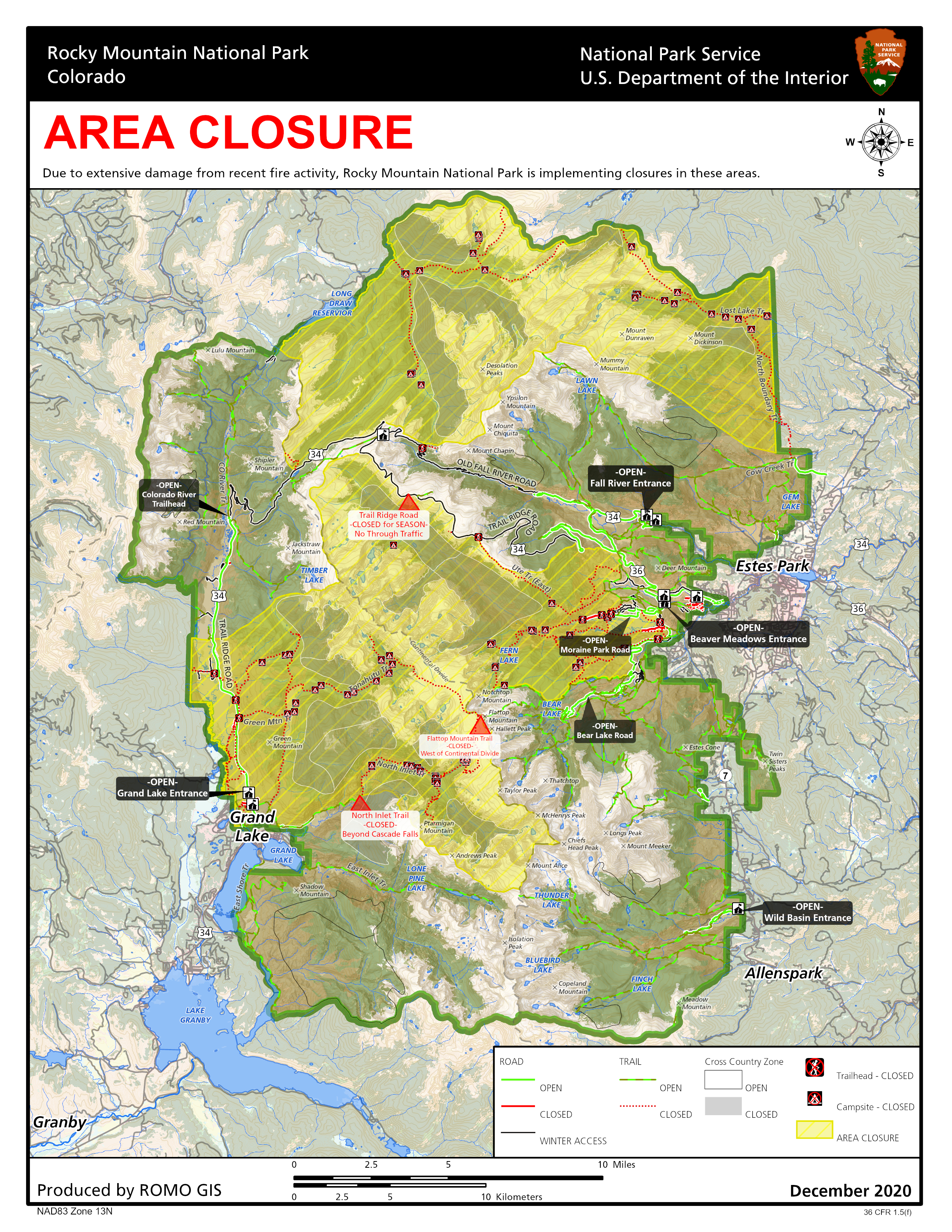
US 34 Reopens On West Side Of Rocky Mountain National Park Additional Areas
Related Incident:
Publication Type: News
Rocky Mountain National Park News Release
For Immediate Release
US 34 Reopens On West Side Of Rocky Mountain National Park
Additional Areas On East Side Reopen
West Side of Rocky Mountain National Park
Today, Thursday, December 10, US Highway 34 from the Grand Lake Entrance to the Colorado River Trailhead reopened in Rocky Mountain National Park. Trail Ridge Road is closed at the Colorado River Trailhead for the winter. Park visitors should not stop or park along the roadside from the Grand Lake Entrance to the Onahu Trail, due to hazard trees along the road from the East Troublesome Fire. There is no access to trails, picnic areas or parking areas along that section of the road including the Harbison Picnic Area, the Green Mountain Trail and the Onahu Trail. The area from the Coyote Valley Trailhead to the north was not impacted by the fire and is accessible. The Bowen-Baker Trail is open inside the park and is closed at the US Forest Service boundary. The Colorado River Trail has reopened to the park boundary. The Timber Lake Trail has reopened. The North Inlet Trail and Sun Valley Trail remain closed.
The Kawuneeche Visitor Center will remain closed until December 19, however restroom facilities are open and park staff will be providing information outside of the visitor center when weather and staffing allow.
East Side of Rocky Mountain National Park
The Moraine Park Campground has reopened and is first-come, first-served during the winter. The Moraine Park Road is open to the campground but is closed beyond that point.
Upper Beaver Meadows Road has reopened to pedestrians, and leashed pets and is closed to vehicles for the winter. The Beaver Meadow Trail at the end of the road remains closed.
The Upper Hidden Valley area has reopened.
In the Bear Lake area, access has reopened from the junction of Flattop Trail to Lake Helene. The trail past Lake Helene to Odessa Lake remains closed. The Flattop Trail is open to the summit of Flattop Mountain but is closed past this point to the west of the Continental Divide.
Trails that remain closed in the Bear Lake area include the Fern Lake Trail, Cub Lake Trail, the Mill Creek Basin, Hollowell Park, and Bierstadt Trail.
Additional areas that will remain temporarily closed to park visitors on the east side of the park include the North Boundary Trail, the North Fork Trail, and Mummy Pass, Stormy Pass, Commanche Peak and Mirror Lake Trails.
Park staff will continue to assess closed areas on both sides of the park for fire impacts, safety and downed trees, being mindful of high winds that occur this time of year causing more trees to fall.
Fire Ban Lifted
The complete fire ban that was put in place in Rocky Mountain National Park on August 14, 2020, has been lifted due to current conditions. Rocky Mountain National Park always has Stage 1 fire restrictions in place, where campfires are prohibited in the park, except within designated campfire rings in picnic areas and front-country campgrounds.
The use of disposable or portable charcoal grills, wood fuel camp stoves and gas grills is allowed. Fireworks are always prohibited within the park. Park visitors are urged to use caution and vigilance regarding the use of fire in authorized locations.
On Wednesday, October 21, the East Troublesome Fire ran approximately 18 miles before it moved into the west side of Rocky Mountain National Park, and then spotted approximately 1.5 miles from the head of Tonahutu Creek on the west side of the Continental Divide to the head of Spruce Creek on the east side of the Continental Divide. Rapid evacuations took place in Grand Lake on October 21. Evacuations for the majority of the Estes Valley were implemented on October 22, as weather predictions forecast major winds on the night of October 23 through October 24 pushing the fire further to the east. Firefighting actions and favorable weather on October 24 and 25, helped halt the major movement of the East Troublesome and Cameron Peak Fires.
Approximately 30,000 acres or 9 percent of Rocky Mountain National Park has been impacted by the East Troublesome and Cameron Peak Fires.
Rocky Mountain National Park’s non-profit partner, The Rocky Mountain Conservancy, is accepting donations to support the park’s future restoration efforts from this season’s fires https://rmconservancy.org/join-or-give/donate/
The East Troublesome Fire and the Cameron Peak Fire have both been declared 100% contained. Pockets of isolated heat may still exist but are not expected to threaten containment lines.
For information on the East Troublesome Fire visit https://inciweb.nwcg.gov/incident/7242/
For information on the Cameron Peak Fire visit https://inciweb.nwcg.gov/incident/6964/
For further information about Rocky Mountain National Park, please visit www.nps.gov/romo or contact the park’s Information Office at 970-586-1206.