
Bear Lake Road Reopens in Rocky Mountain National Park
Related Incident:
Publication Type: News
Rocky Mountain National Park News Release
Bear Lake Road Reopens in Rocky Mountain National Park
Most Trails West of Bear Lake Road Remain Closed
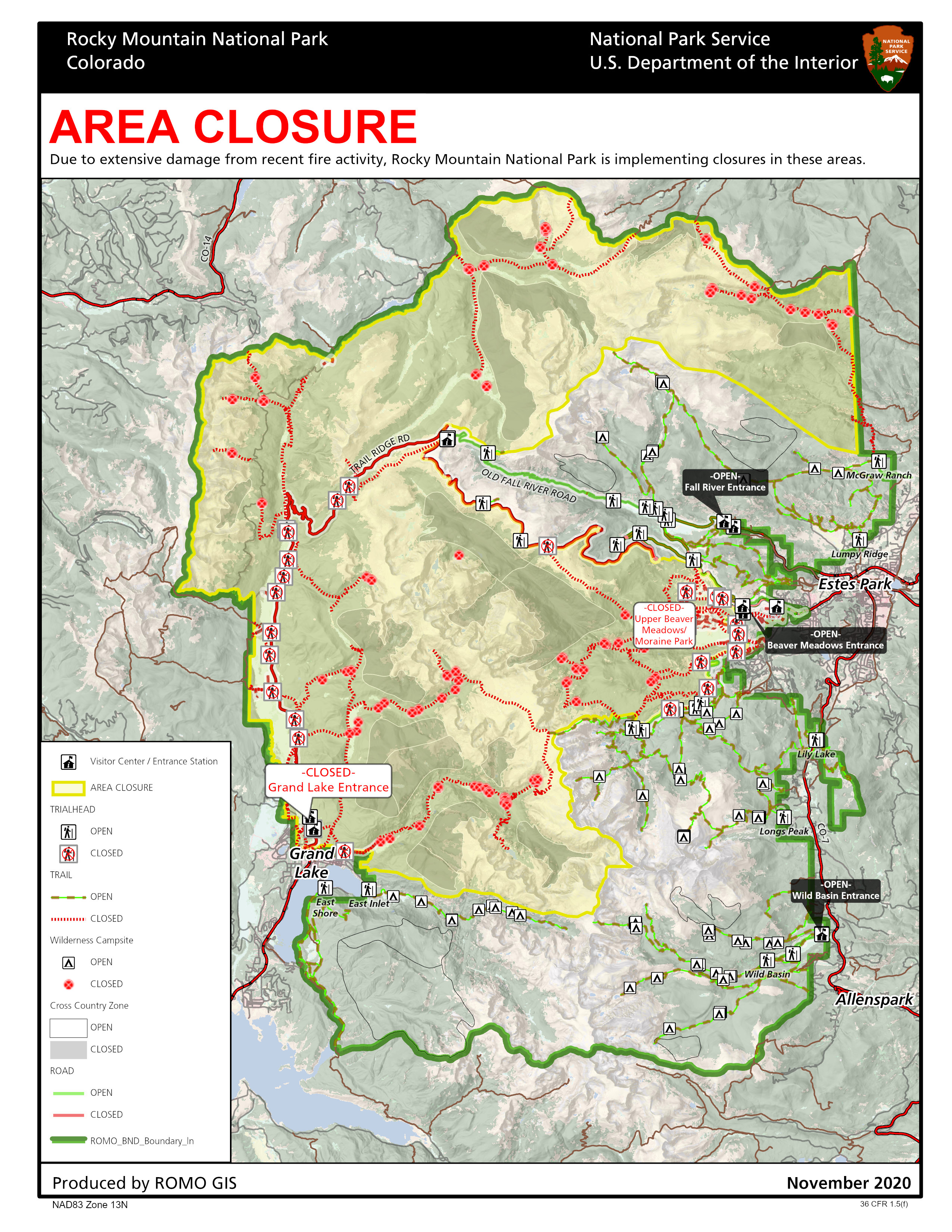
Bear Lake Road in Rocky Mountain National Park reopened today after being closed since October 22, due to the East Troublesome Fire. All areas and trails east of Bear Lake Road have reopened.
Most areas west of Bear Lake Road remain closed including the Moraine Park Road at the junction of Bear Lake Road and the Moraine Park Campground. Trails that remain closed include the Fern Lake Trail, Cub Lake Trail, the Mill Creek Basin, Hollowell Park, and Bierstadt Trail.
The trail system in the Bear Lake area has reopened. The Flattop Trail is open to the summit of Flattop Mountain but is closed past this point to the west of the Continental Divide. The Odessa/Fern Lake Trail is closed at the Odessa/Flattop Trail junction. The Bierstadt Trail is also closed at the Bear Lake/Bierstadt Trail junction.
The west side of Rocky Mountain National Park remains closed past the Grand Lake Entrance as does the North Inlet Trail and the Sun Valley Trail, due to the level of fire impacts and ongoing safety assessments.
Additional areas that will remain temporarily closed to park visitors on the east side of the park include Upper Beaver Meadows Road, the North Boundary Trail, the North Fork Trail, and Mummy Pass, Stormy Pass, Commanche Peak and Mirror Lake Trails. Park staff will continue to assess these areas for fire activity, safety and downed trees, being mindful of high winds that occur this time of year causing more trees to fall.
On Wednesday, October 21, the East Troublesome Fire ran approximately 18 miles before it moved into the west side of Rocky Mountain National Park, and then spotted approximately 1.5 miles from the head of Tonahutu Creek on the west side of the Continental Divide to the head of Spruce Creek on the east side of the Continental Divide. Rapid evacuations took place in Grand Lake on October 21. Evacuations for the majority of the Estes Valley were implemented on October 22, as weather predictions forecast major winds on the night of October 23 through October 24 pushing the fire further to the east. Firefighting actions and favorable weather on October 24 and 25, helped halt the major movement of the East Troublesome and Cameron Peak Fires.
Approximately 30,000 acres or 9 percent of Rocky Mountain National Park has been impacted by the East Troublesome and Cameron Peak Fires.
Rocky Mountain National Park’s non-profit partner, The Rocky Mountain Conservancy, is accepting donations to support the park’s future restoration efforts from this season’s fires https://rmconservancy.org/join-or-give/donate/
For information on the East Troublesome Fire visit https://inciweb.nwcg.gov/incident/7242/
For information on the Cameron Peak Fire visit https://inciweb.nwcg.gov/incident/6964/
For further information about Rocky Mountain National Park, please visit www.nps.gov/romo or contact the park’s Information Office at 970-586-1206.
This information including the map can be found at the park's website at: https://www.nps.gov/romo/learn/fire-information-and-regulations.htm
More Areas In Rocky Mountain National Park Reopen
Related Incident:
Publication Type: News
Additional areas in Rocky Mountain National Park will reopen after being closed since October 22, due to the East Troublesome Fire. Tomorrow, Saturday, November 14, US 36 past the Beaver Meadows Visitor Center to Deer Ridge Junction will reopen, including the Beaver Meadows Entrance Station. On the east side of the park Trail Ridge Road is open to Many Parks Curve. The ongoing road construction project between Beaver Meadows Entrance Station and Deer Ridge Junction will continue again on Monday, November 16; visitors should expect up to 20-minute delays from 7 am to 5 pm.
The East Inlet Trail and the East Shore Trail on the west side of Rocky Mountain National Park have reopened.
The west side of Rocky Mountain National Park remains closed past the Grand Lake Entrance as does the North Inlet Trail and the Sun Valley Trail, due to the level of fire impacts and ongoing safety assessments.
Areas that will remain temporarily closed to park visitors on the east side of the park include Bear Lake Road, Upper Beaver Meadows Road, the North Boundary Trail, the North Fork Trail, and Mummy Pass, Stormy Pass, Commanche Peak and Mirror Lake Trails. Park staff will continue to assess these areas for fire activity, safety and downed trees, being mindful of high winds that occur this time of year causing more trees to fall.
On Wednesday, October 21, the East Troublesome Fire ran approximately 18 miles before it moved into the west side of Rocky Mountain National Park, and then spotted approximately 1.5 miles from the head of Tonahutu Creek on the west side of the Continental Divide to the head of Spruce Creek on the east side of the Continental Divide. Rapid evacuations took place in Grand Lake on October 21. Evacuations for the majority of the Estes Valley were implemented on October 22, as weather predictions forecast major winds on the night of October 23 through October 24 pushing the fire further to the east. Firefighting actions and favorable weather on October 24 and 25, helped halt the major movement of the East Troublesome and Cameron Peak Fires.
Park visitors should be aware of smoke, wind, weather and fire conditions.
Approximately 30,000 acres or 9 percent of Rocky Mountain National Park has been impacted by the East Troublesome and Cameron Peak Fires.
Rocky Mountain National Park’s non-profit partner, The Rocky Mountain Conservancy, is accepting donations to support the park’s future restoration efforts from this season’s fires https://rmconservancy.org/join-or-give/donate/
For information on the East Troublesome Fire visit https://inciweb.nwcg.gov/incident/7242/
For information on the Cameron Peak Fire visit https://inciweb.nwcg.gov/incident/6964/
For further information about Rocky Mountain National Park, please visit www.nps.gov/romo or contact the park’s Information Office at 970-586-1206.
East Troublesome Fire Thompson Zone Sees No Growth
Related Incident:
Publication Type: News
Rocky Mountain National Park News Release:
The Thompson Zone of the East Troublesome Fire, on the east side of the Continental Divide within Rocky Mountain National Park, was previously managed by the Cameron Peak Fire team and has been transitioned back to the East Troublesome Fire team. The East Troublesome Fire is currently being managed by a Type 3 Incident Management Team. The Thompson Zone is being managed by a Division Group Supervisor, located within the park, who reports to the Incident Commander.
The recent snow has diminished much of the smoke producing heat coming from the interior of the fire within Rocky Mountain National Park. Prior to this recent snow, the only heat observed was high on Beaver Mountain and on the back side of Mount Wuh, in steep terrain with beetle kill, snags and dead and down trees. These areas have been tested by high winds and the fire has not moved.
The fire is secure on the eastern flanks where firefighters have had access to mop up heat. Fire managers continue to assess weather and fire danger calculations and there is currently no threat from the fire to move toward the Estes Valley.
Approximately 30,000 acres or 9 percent of Rocky Mountain National Park has been impacted by the East Troublesome and Cameron Peak Fires. Some areas of the park remain closed https://www.nps.gov/romo/learn/fire-information-and-regulations.htm
Rocky Mountain National Park’s non-profit partner, The Rocky Mountain Conservancy, is accepting donations to support the park’s future restoration efforts from this season’s fires https://rmconservancy.org/join-or-give/donate/
For information on the East Troublesome Fire visit https://inciweb.nwcg.gov/incident/7242/.
For information on the Cameron Peak Fire visit https://inciweb.nwcg.gov/incident/6964/.
USFS fire restrictions rescinded on lands managed by MBRTB
Related Incident:
Publication Type: Announcement
*News Release - Fire restrictions for National Forest System lands managed by the Medicine Bow-Routt National Forests & Thunder Basin National Grassland have been fully rescinded.
Areas of Arapahho and Roosevelt National Forest to open Tuesday Nov 10th
Related Incident:
Publication Type: Closures
More areas of Arapaho and Roosevelt National Forests to reopen Tuesday
Forest remains in fire ban with closures around wildfire areas
Learn more about our fire restrictions and fire closure areas.
East Troublesome Fire Update for Nov 6 2020
Related Incident:
Publication Type: News
See below in related information to view the article.
Rehabilitation of a Dozer Line
Related Incident:
Publication Type: News
See below in related information to view the article.
One Way to Reduce Soil Erosion Construct a Waterbar
Related Incident:
Publication Type: News
See below in related information to view the article.
Launching a Weather Balloon on a Wildfire
Related Incident:
Publication Type: News
See below in related information to view the article.
Rocky Mountain National Park announces some areas reopening
Related Incident:
Publication Type: Announcement
Rocky Mountain National Park announces that many areas will reopen.
Good news! Tomorrow, Friday, November 6, many areas of Rocky Mountain National Park will reopen. Visit https://go.nps.gov/nov6 to see what areas of the park will be open.The west side of Rocky Mountain National Park remains closed due to the level of fire impacts and ongoing safety assessments. Park visitors should be aware of smoke, wind, weather and fire conditions. For the most up-to-date information on the East Troublesome Fire visit https://inciweb.nwcg.gov/incident/7242/For the most up-to-date information on the Cameron Peak Fire visit https://inciweb.nwcg.gov/incident/6964/ For information about Rocky Mountain National Park, please visit www.nps.gov/romo or contact the park’s Information Office at 970-586-1206.