
Robertson Draw Fire Fact Sheet 72121
Related Incident:
Publication Type: News
Location: 7 miles south of Red Lodge, Montana
Incident Command: Type 3 Incident Management Team, Shawn Gettings – Incident Commander
Size: 29,841 acres
Containment: 85%
Personnel: 58
Current Status: Fire activity has remained moderate along the western perimeter which will be the priority area to secure. Ground crews were flown in closer to the priority area by helicopter to check, improve, and construct containment lines. Isolated torching and spotting was observed within the fire perimeter.
Evacuation Warnings: The evacuation warning issued on 7/19/21 by Carbon County Sheriff’s Office has been lifted. Residents should continue to stay updated and aware of the fire situation.
Planned Actions: Additional resources have arrived to assist with securing the priority area and uncontained portions of the fire perimeter. A Surge Team, consisting of two Hotshot Crew and a 20-person Type 2 Initial Attack Crew, will be supporting existing crews for the next several days. Their focus will be checking, improving, and constructing line along the western fire perimeter. Handcrews will also continue working on line construction on the northwest portion of the fire. Aerial resources will assist with bucket drops as needed and available.
Weather and Fuel Conditions: Today will be mostly sunny to partly sunny with the chance of showers and thunderstorms in the afternoon and evening. Gusty and erratic winds may be present near storms. Humidity will be 33-37% with nighttime recover of 45-50%. On Thursday, we may expect more storms with gusty and erratic winds.
Closures: The Custer Gallatin National Forest lands south of Point of Rocks and east of Highway 212 and east of Wyoming Creek are closed with the following exceptions: Sheridan and Rattin Campgrounds, the Westminster Church Camp and the summer residences at Corral Creek and Spring Creek. A Closure Order is in effect on all Bureau of Land Management lands lying West of State Highway 72, South of State Highway 308, and East of US Highway 212 in Carbon County. The North and South Grove Creek Road, Gold Creek Road, Ruby Creek Road, Meeteetse Trail, and Robertson Draw Road to the state line is closed to public use. If you are visiting the area, please check alerts and closures https://www.fs.usda.gov/alerts/custergallatin/alerts-notices.
Temporary Flight Restrictions (TFR): A TFR is currently issued for air space over the Robertson Draw Fire (FDC 1/1687) to provide a safe environment for firefighting aircraft operating in the area. Remember that temporary flight restrictions also apply to unmanned aircraft systems (UAS) or drones. If you fly, we can’t! More information on the TFR can be found here https://tfr.faa.gov/save_pages/detail_1_1687.html.
Primary and Cooperating Agencies: USFS, DNRC, BLM, Carbon County Sheriff’s Office, DES, and Road Department, Red Lodge Fire District, and Belfry Fire District
Robertson Draw Fire Fact Sheet 72021
Related Incident:
Publication Type: News
Location: 7 miles south of Red Lodge, Montana Incident Command: Type 3 Incident Management Team, Shawn Gettings – Incident CommanderSize: 29,841 acres
Containment: 85%
Personnel: 49
Current Status: Fire activity increased yesterday along the western perimeter. A large helicopter performed water drops on the area. Additional aerial resources were requested including an Air Attack (AA) providing a better size-up of fire activity and two Large Airtankers (LATs) performing two retardant drops each on the northwestern perimeter. Fire activity diminished yesterday evening but residents and visitors should remain vigilant and maintain awareness of the fire situation and surroundings.
Evacuation Warnings: Due to elevated weather conditions and the increase in fire activity, Carbon County Sheriff’s Office issued an Evacuation Warning for the Rock Creek Drainage area from Point of Rocks just south of Red Lodge, following south on both the east and west sides of HWY 212. An evacuation warning is issued from the county sheriff and alerts residents and visitors to be ready to go in the event an evacuation order is issued. People with medical, functional, or other needs should consider evacuating if possible.
Planned Actions: A team will hike up to the location of yesterday’s increase in fire activity. Other crews will continue handline construction and engine crews will review Structure Protection Plans for the area. Aerial resources have been requested and will be utilized based on availability and needs.
Weather and Fuel Conditions: A Red Flag Warning will be in place today (Tuesday). The Red Flag Warning is in effect until midnight tonight. There is a better chance of thunderstorms today and a mix of wet and dry storm with strong, gusty winds can be expected in the afternoon and evening. Minimum humidity levels will be 21-26% with nighttime recovery at 54-58%.
Closures: The Custer Gallatin National Forest lands south of Point of Rocks and east of Highway 212 and east of Wyoming Creek are closed with the following exceptions: Sheridan and Rattin Campgrounds, the Westminster Church Camp and the summer residences at Corral Creek and Spring Creek. A Closure Order is in effect on all Bureau of Land Management lands lying West of State Highway 72, South of State Highway 308, and East of US Highway 212 in Carbon County. The North and South Grove Creek Road, Gold Creek Road, Ruby Creek Road, Meeteetse Trail, and Robertson Draw Road to the state line is closed to public use. If you are visiting the area, please check alerts and closures https://www.fs.usda.gov/alerts/custergallatin/alerts-notices.
Temporary Flight Restrictions (TFR): A TFR will be in place at 1300 today, July 19th, for air space over the Robertson Draw Fire (FDC 1/1687) to provide a safe environment for firefighting aircraft operating in the area. Remember that temporary flight restrictions also apply to unmanned aircraft systems (UAS) or drones. If you fly, we can’t! More information on the TFR can be found here https://tfr.faa.gov/save_pages/detail_1_1687.html.
Primary and Cooperating Agencies: USFS, DNRC, BLM, Carbon County Sheriff’s Office, DES, and Road Department, Red Lodge Fire District, and Belfry Fire District
Evacuation Warning Issued per Carbon County Sheriffs Office
Related Incident:
Publication Type: Announcement
Due to fire activity near Seeley Creek Drainage and the current weather conditions the Carbon County Sheriff's Office, in conjunction with Red Lodge Fire Rescue, has issued an evacuation warning for the Rock Creek Drainage from Point of Rocks just south of Red Lodge, following south on HWY 212. An evacuation warning is issued from the county sheriff and alerts people to be ready to go in the event an evacuation order is issued. People with medical, functional, or other needs should consider evacuating if possible. Please contact the Public Information Officer at 406-290-3559 for any questions.
Increase in fire activity July 19 2021
Related Incident:
Publication Type: Announcement
An increase in fire activity on the Robertson Draw Fire has been observed this afternoon. Smoke is originating from the western fire perimeter. Additional aerial resources have been ordered and a large helicopter is currently dropping water on the area. If you have any questions, please call the information line at 406-290-3559.
Robertson Draw Fire Fact Sheet July 19 2021
Related Incident:
Publication Type: News
Location: 7 miles south of Red Lodge, Montana
Incident Command: Type 3 Incident Management Team, Shawn Gettings – Incident Commander
Size: 29,841 acres
Containment: 85%
Personnel: 49
Current Status: Fire activity has remained low with no additional fire growth. The hot spots in the northwest part of the fire are still present with a helicopter performing bucket drops on the area. Residents and visitors of Red Lodge may continue to see smoke from the northwest edge, along Mt. Maurice, as the weather continues to be hot and dry. A fresh Type 3 Incident Management Team is completing its transition with the previous team today. The Incident Command Post has completed its relocation to the Timbercrest Girl Scout Camp west of Red Lodge. Please call the public information line for more information about the fire at (406) 290-3559.
Planned Actions: Ground crews have been making excellent progress in constructing handline on the uncontained northwestern portion of the fire on Mt. Maurice. Today, crews will begin digging handline from the bottom and move up the ridgeline. A thunderstorm cell is expected to move across work area around 1400 today (Monday). Aerial resources will be utilized if available to address the heat pockets on Mt. Maurice. The primary area of concern continues to be the uncontained northwestern fire perimeter on Mt. Maurice. Aerial and ground crews continue to monitor and patrol the area for fire activity as well as scout hazards in order to determine the best strategy in finalizing containment. Incoming command staff will be surveying the fire aerially this morning.
Weather and Fuel Conditions: A Heat Advisory and Red Flag Warning will be in place today (Monday). The Heat Advisory is currently in effect until Tuesday evening. The Red Flag Warning will be in effect at noon today until midnight Tuesday night. Humidity levels will be low at 27-31% with nighttime recovery at 40-46% tonight. A thunderstorm cell will be moving into the area at around 1400 today with may bring some rain but will also bring lightning. Residents and visitors should follow area fire restrictions, which can be found here https://www.mtfireinfo.org/. Carbon County is under Stage 2 Fire Restrictions.
Closures: The Custer Gallatin National Forest lands south of Point of Rocks and east of Highway 212 and east of Wyoming Creek are closed with the following exceptions: Sheridan and Rattin Campgrounds, the Westminster Church Camp and the summer residences at Corral Creek and Spring Creek. A Closure Order is in effect on all Bureau of Land Management lands lying West of State Highway 72, South of State Highway 308, and East of US Highway 212 in Carbon County. The North and South Grove Creek Road, Gold Creek Road, Ruby Creek Road, Meeteetse Trail, and Robertson Draw Road to the state line is closed to public use. If you are visiting the area, please check alerts and closures https://www.fs.usda.gov/alerts/custergallatin/alerts-notices.
Temporary Flight Restrictions (TFR): A TFR will be in place at 1300 today, July 19th, for air space over the Robertson Draw Fire (FDC 1/1687) to provide a safe environment for firefighting aircraft operating in the area. Remember that temporary flight restrictions also apply to unmanned aircraft systems (UAS) or drones. If you fly, we can’t! More information on the TFR can be found here https://tfr.faa.gov/save_pages/detail_1_1687.html.
Primary and Cooperating Agencies: USFS, DNRC, BLM, Carbon County Sheriff’s Office, DES, and Road Department, Red Lodge Fire District, and Belfry Fire District
Heat Advisory in Effect Increase in IA response
Related Incident:
Publication Type: Announcement
A heat advisory is in effect for central and south central Montana until Tuesday. With several new fire starts in the region, a 10-person crew was reassigned to assist with initial attack efforts yesterday and will continue fire suppression efforts on the American Fork Fire today. Remaining crews on the Robertson Draw Fire made great progress in constructing handline yesterday. Due to the heat advisory in place and the long, steep hike to get to the work area, a sling load operation will be taking place this morning. Equipment, such as chainsaws and fuel, will be secured at the end of a long rope underneath the helicopter and transported close to the work area. Crews will continue working on handline construction today.
Robertson Draw Fire Fact Sheet July 17 2021
Related Incident:
Publication Type: News
Location: 7 miles south of Red Lodge, Montana Incident Command: Type 3 Incident Management Team, Dan Bartel – Incident CommanderSize: 29,841 acres
Containment: 85%
Personnel: 68
Current Status: Fire activity has remained low with no additional fire growth. A few hot spots flared up in isolated areas along the northwestern edge of the fire. A Type 1 helicopter assisted with bucket drops on the area. Residents and visitors of Red Lodge may continue to see smoke from the northwest edge, along Mt. Maurice, as the weekend is expected to continue to be hot and dry. Rehabilitation and repair has been completed on the eastern side of the fire.
Planned Actions: Crews will patrol and monitor the fire perimeter through the weekend. Rehabilitation and repair will also continue in those areas affected by fire suppressions efforts. Aerial resources will be utilized if available to address the heat pockets on Mt. Maurice. Crews will begin constructing handline in the northwestern area of the fire. The primary area of concern continues to be the uncontained northwestern fire perimeter on Mt. Maurice. Aerial and ground crews continue to monitor and patrol the area for fire activity as well as scout hazards in order to determine the best strategy in finalizing containment. On Sunday, a new Type 3 Incident Management Team will begin transitioning with the previous team and will relocate the Incident Command Post to the Timbercrest Girl Scout Camp west of Red Lodge.
Weather and Fuel Conditions: Weather conditions will remain on a hot and dry trend through the weekend with the possibility of dry lightning activity. There is expected to be 0% chance of wetting rain today and Sunday. Low humidity values of 11% along with overnight values of 25% may contribute to lower fuel moistures. Fuels with low moisture levels will more readily ignite. Residents and visitors should follow area fire restrictions, which can be found here https://www.mtfireinfo.org/. Carbon County is under Stage 2 Fire Restrictions.
Closures: The Custer Gallatin National Forest lands south of Point of Rocks and east of Highway 212 and east of Wyoming Creek are closed with the following exceptions: Sheridan and Rattin Campgrounds, the Westminster Church Camp and the summer residences at Corral Creek and Spring Creek. A Closure Order is in effect on all Bureau of Land Management lands lying West of State Highway 72, South of State Highway 308, and East of US Highway 212 in Carbon County. The North and South Grove Creek Road, Gold Creek Road, Ruby Creek Road, Meeteetse Trail, and Robertson Draw Road to the state line is closed to public use. If you are visiting the area, please check alerts and closures https://www.fs.usda.gov/alerts/custergallatin/alerts-notices.
Primary and Cooperating Agencies: USFS, DNRC, BLM, Carbon County Sheriff’s Office, DES, and Road Department, Red Lodge Fire District, and Belfry Fire District
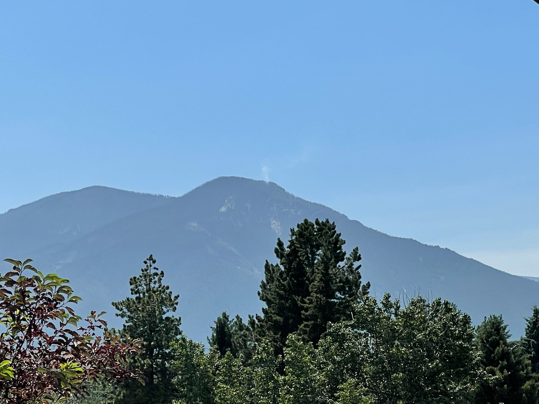
Some Increased Activity on Robertson Draw Fire
Related Incident:
Publication Type: Announcement
A good reminder that despite the recent rain and better temperatures, the Robertson Draw Fire is not yet out. A new plume has popped up on the summit of Mt. Maurice this afternoon along the uncontained fire line. Fire crews are aware of this new smoke. The Robertson Draw Fire Information phone line is still operational at 406-290-3559, please call us with any questions you have.
Robertson Draw Fire Fact Sheet July 7th 2021
Related Incident:
Publication Type: News
Location: 7 miles south of Red Lodge, Montana Incident Command: Type 3 Incident Management Team, Dan Bartel – Incident Commander Size: 29,841 acres Containment: 69% Personnel: 162
Current Status: Fire activity is low, though isolated areas of heat remain along the western edge of the fire. Smoke may be seen in these areas, increasing with the heat of the day. Some resources have been temporarily allocated to the Section House Fire in the Pryor Mountains, approximately 30 miles from Red Lodge, which has grown to about 100 acres. Today at 0600 a Type 3 Incident Management team took command over the Robertson Draw Fire.
Planned Actions: Rehabilitation and repair of contained areas affected by firefighting efforts will continue, while fire crews will continue to patrol and mop up pockets of heat along the north and west ends of the fire. On the eastern side of the fire, crews will continue to patrol and monitor for spotting.
Weather and Fuel Conditions: A warm and dry trend will continue with a small chance of afternoon thunderstorms the next several days, with relative humidity being lowest on Thursday afternoon. A cold front will be passing through the area late Thursday, bringing cooler temperatures and the chance for precipitation on Friday, but also shifting winds and lightning. Despite recent rain fuels are still relatively dry, and receptive to fire.
Closures: The Custer Gallatin National Forest lands south of Point of Rocks and east of Highway 212 and east of Wyoming Creek are closed with the following exceptions: Sheridan and Rattin Campgrounds, the Westminster Church Camp and the summer residences at Corral Creek and Spring Creek. A Closure Order is in effect on all Bureau of Land Management lands lying West of State Highway 72, South of State Highway 308, and East of US Highway 212 in Carbon County. The North and South Grove Creek Road, Gold Creek Road, Ruby Creek Road, Meeteetse Trail, and Robertson Draw Road to the state line is closed to public use.
Primary and Cooperating Agencies: USFS, DNRC, BLM, Carbon County Sheriff’s Office, DES, and Road Department, Red Lodge Fire District, and Belfry Fire District
Robertson Draw Fire Fact Sheet July 6 2021
Related Incident:
Publication Type: News
Location: 7 miles south of Red Lodge, Montana
Incident Command: Type 2 Northern Rockies Incident Management Team 3 – Mike Almas, Incident Commander
Size: 29,841 acres Containment: 69% Personnel: 175
This will be the last fire update from the Northern Rockies Incident Management Team 3. Incident Commander Dan Bartel from the BLM will assume management of the fire at 6:00 a.m. on Wednesday, July 7, 2021. Please call the Beartooth Ranger District office at 406-446-2103 or visit InciWeb for current fire information.
Precipitation was received over the fire area yesterday. Firefighters monitored and further secured completed line. Smoke was seen in the northwest corner of the fire area, crews were closely monitoring and no air response was needed. Initial attack forces were staged on the northwest and east side of the fire. There were no reports of new fire starts yesterday.
Today, fire crews will continue to patrol, monitor and mop up any pockets of heat around the fire edge to further improve completed line. Air support will be available as needed for inaccessible area. Fire personnel are staged on the northwest and east side of the fire will be ready for initial attack response.
Closures: The Custer Gallatin National Forest lands south of Point of Rocks and east of Highway 212 and east of Wyoming Creek are closed with the following exceptions: Sheridan and Rattin Campgrounds, the Westminster Church Camp and the summer residences at Corral Creek and Spring Creek. A Closure Order is in effect on all Bureau of Land Management lands lying West of State Highway 72, South of State Highway 308, and East of US Highway 212 in Carbon County. The North and South Grove Creek Road, Gold Creek Road, Ruby Creek Road, Meeteetse Trail, and Robertson Draw Road to the state line is closed to public use.
Weather and Fuel Conditions: Slight chance of showers and thunderstorms this afternoon, decreasing chances this evening. Any precipitation amounts will be light. Temperatures near the fire area will be in low 80s. Relative humidity will be around 20 to 32% and terrain driven winds are expected.
Temporary Flight Restrictions (TFR): A TFR is in place for air space over the Robertson Draw Fire (FDC 1/0096) to provide a safe environment for firefighting aircraft operating in the area. Remember that temporary flight restrictions also apply to unmanned aircraft systems (UAS) or drones. If you fly, we can’t!
Primary and Cooperating Agencies: USFS, DNRC, BLM, Carbon County Sheriff’s Office, DES, and Road Department, Red Lodge Fire District, and Belfry Fire District