
Robertson Draw Fire Fact Sheet June 27 2021
Related Incident:
Publication Type: News
Robertson Draw Fire
Sunday, June 27, 2021 at 8:00AM
Inciweb: https://inciweb.nwcg.gov/incident/7537/
Email: 2021.RobertsonDraw@firenet.gov
Facebook: https://www.facebook.com/custergallatin/
Public Information Phone: (406) 290-3559
https://www.facebook.com/redlodgefire/
Location: 7 miles south of Red Lodge, Montana
Incident Command: Type 2 Northern Rockies Incident Management Team 4, Brian Jenkins – Incident Commander
Size: 29,838 acres Containment: 65% Personnel: 307
Current Status: Yesterday, crews continued to patrol and mop up along the southern and eastern side of the fire. Mop up work continued to cool some pockets of heat in an aspen grove. Some suppression repair work on interior fire lines was completed. Perimeter fire lines remain in place although some erosion control work was done to prevent soil runoff. On the northwest side firefighters continued to mop up and search for hot spots along hand lines. The chipping of woody debris work along the East Side Road was completed. The Structure Group assisted with the chipping work being done along the East Side Road. The initial attack group was prepared to respond to any new fires. Assistance was provided when requested for a new initial attack fire east of Billings. The fire area did receive some rainfall again from passing storms.
Planned Actions: The south and east sides of the fire will continue to be patrolled and monitored for any hot spots or pockets of heat along the containment lines. Crews will grid the fire edge again and look for pockets of heat. Gridding involves working across the fire’s edge in an organized manner to make sure that pockets of heat are discovered and cooled down. Suppression repair of interior dozer lines will be continued on the eastern side. On the northwest side firefighters will continue to patrol and monitor the hand lines. The structure protection group will work on some additional fuels reduction planning. If the weather clears, firefighters will return to the plateau and south of Mt. Maurice area on the west side of the fire to check on that area. The initial attack group will remain prepared to respond to any new fire starts.
Evacuation Warnings: Evacuation Warnings remain in effect for the areas located south of Red Lodge and east of US Highway 212. The North and South Grove Creek Road, Gold Creek Road, Ruby Creek Road, Meeteetse Trail, and Robertson Draw Road are closed to public use. It is recommended that all area residents have a household evacuation plan. Please remain vigilant and be aware of the fire situation and your surroundings.
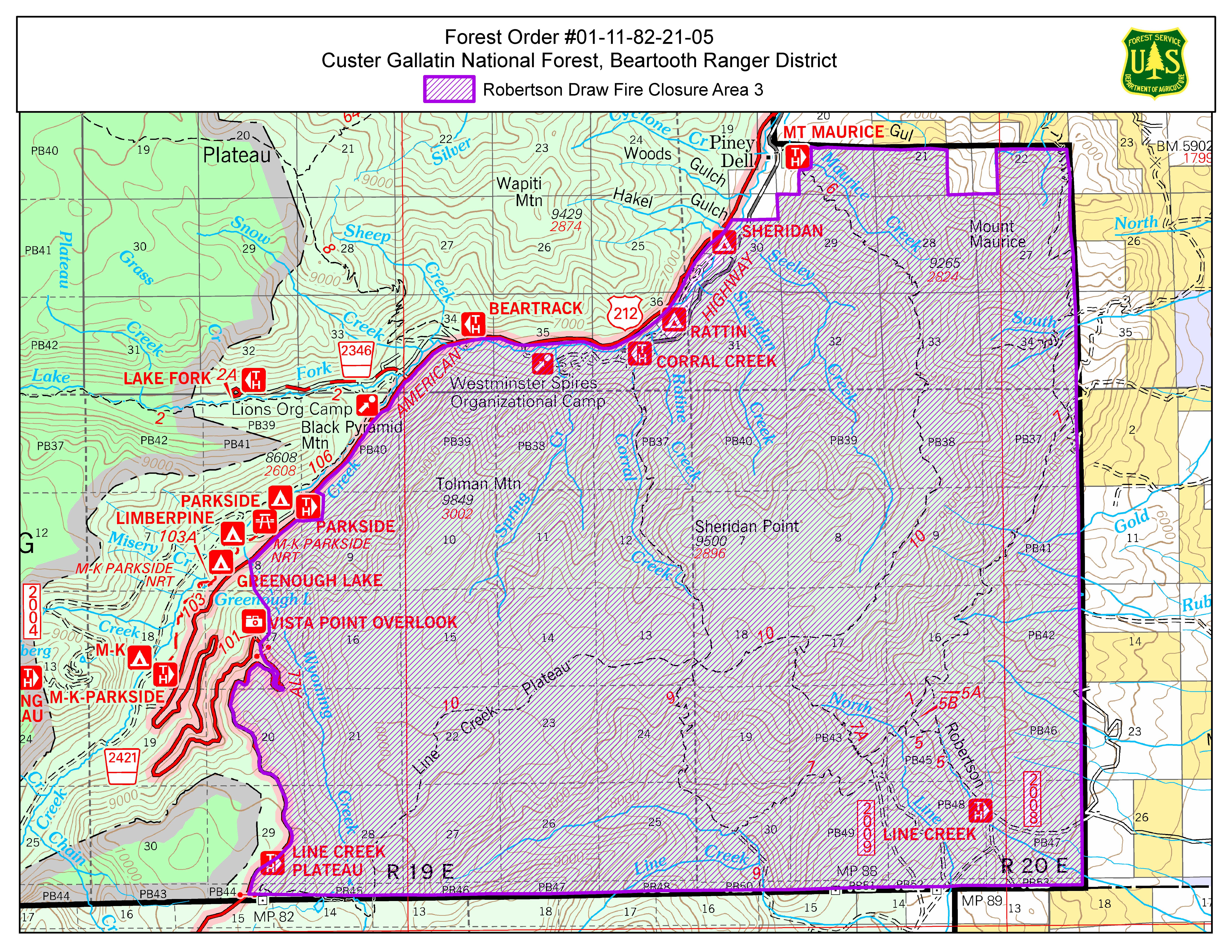
Closures: All Custer Gallatin National Forest System lands south of Point of Rocks in the Rock Creek drainage and east of US Highway 212 are still closed under a new Forest Closure Order. This includes trailheads, campgrounds, dispersed camping areas, and the USDA Forest Service Recreation Residences in Corral Creek and Spring Creek. This is in addition to the Closure Area encompassing the Line Creek Plateau.A Closure Order is also in effect on all Bureau of Land Management lands lying West of State Highway 72, South of State Highway 308, and East of US Highway 212 in Carbon County.
Temporary Flight Restrictions (TFR): A TFR is in place for air space over the Robertson Draw Fire (FDC 1/0096) to provide a safe environment for firefighting aircraft operating in the area. Remember that temporary flight restrictions also apply to unmanned aircraft systems (UAS) or drones. If you fly, we can’t!
Primary and Cooperating Agencies: USFS, DNRC, BLM, Carbon County Sheriff’s Office, DES, and Road Department, Red Lodge Fire District, and Belfry Fire District
Robertson Draw Fire Fact Sheet June 26 2021
Related Incident:
Publication Type: News
Robertson Draw FireSaturday, June 26, 2021 at 8:00AM
Inciweb: https://inciweb.nwcg.gov/incident/7537/
Email: 2021.RobertsonDraw@firenet.govFacebook: https://www.facebook.com/custergallatin/
Public Information Phone: (406) 290-3559https://www.facebook.com/redlodgefire/
Location: 7 miles south of Red Lodge, MontanaIncident Command: Type 2 Northern Rockies Incident Management Team 4, Brian Jenkins – Incident Commander
Size: 29,838 acres Containment: 65% Personnel: 327
Current Status: Yesterday, crews continued to patrol and mop up along the southern and eastern side of the fire. Work continued to cool some pockets of heat in the aspen grove like previous days but only a couple of spots were needing to be worked on. On the northwest side firefighters continued to mop up and search for hot spots along the hand line as well as continued work chipping woody debris along the East Side Road as a part of a contingency line tied into US Highway 212. The Structure Group finalized the equipment list that is needed to set up structure protection actions in the Highway 212 corridor. An initial attack group was identified and prepared to respond to any new fires. The fire area did receive some rainfall from passing storms.
Planned Actions: The south and east sides of the fire will continue to be patrolled and monitored for any hot spots or pockets of heat along the containment lines. Crews will grid the fire area for heat and hot spots.
Gridding involves working across the fire’s edge in an organized manner to make sure that pockets of heat are discovered and cooled down. Some suppression repair of interior dozer lines is planned to be done. On the northwest side firefighters will continue to construct the contingency fire line between the fire area and the East Side Road and use a chipper to dispose of the wood debris and haul it away. If the weather clears, firefighters will return to the plateau and south of Mt. Maurice area on the west side of the fire to check on that area. An initial attack group is identified and will be prepared to respond to any new fire starts.
Evacuation Warnings: Evacuation Warnings remain in effect for the areas located south of Red Lodge and east of US Highway 212. The North and South Grove Creek Road, Gold Creek Road, Ruby Creek Road, Meeteetse Trail, and Robertson Draw Road are closed to public use. It is recommended that all area residents have a household evacuation plan. Please remain vigilant and be aware of the fire situation and your surroundings.
Closures: The Forest Closure Order changed at 8:00 am today and lands west of US Highway 212 are now open to public use. All Custer Gallatin National Forest System lands south of Point of Rocks in the Rock Creek drainage and east of US Highway 212 are still closed under a new Forest Closure Order. This includes trailheads, campgrounds, dispersed camping areas, and the USDA Forest Service Recreation Residences in Corral Creek and Spring Creek. This is in addition to the Closure Area encompassing the Line Creek Plateau.
A Closure Order is also in effect on all Bureau of Land Management lands lying West of State Highway 72, South of State Highway 308, and East of US Highway 212 in Carbon County.
Temporary Flight Restrictions (TFR): A TFR is in place for air space over the Robertson Draw Fire (FDC 1/0096) to provide a safe environment for firefighting aircraft operating in the area. Remember that temporary flight restrictions also apply to unmanned aircraft systems (UAS) or drones. If you fly, we can’t!
Primary and Cooperating Agencies: USFS, DNRC, BLM, Carbon County Sheriff’s Office, DES, and Road Department, Red Lodge Fire District, and Belfry Fire District
Some Forest Closures Lifting June 26th at 8am
Related Incident:
Publication Type: Announcement
Beginning Saturday, June 26th 2021 at 8am, the Forest Closure will be lifted in the area on the west side of Highway 212 (the Beartooth Highway) and trails, facilities, campgrounds, and Snow and Sheep Creek Recreation Residences will be accessible to the public. This includes the Lake Fork trail, Parkside, Greenough, Limber Pine, and MK Campgrounds.
The area east of Highway 212 from the forest boundary to the Wyoming state line, encompassing all of the Line Creek plateau, Rattin and Sheridan Campgrounds, Spring Creek and Corral Creek Recreation Residences will remain closed until further notice.
A reminder that the entire Custer Gallatin National Forest is under fire restrictions. On the Beartooth Ranger District NO FIRES are permitted, metal camp ring or otherwise. Camp stoves powered by gas with an on and off switch are allowed.
Robertson Draw Fire Fact Sheet June 25 2021 at 8 AM
Related Incident:
Publication Type: News
Robertson Draw Fire
Friday, June 25, 2021 at 8:00AM
Inciweb: https://inciweb.nwcg.gov/incident/7537/
Email: 2021.RobertsonDraw@firenet.gov
Facebook: https://www.facebook.com/custergallatin/
Public Information Phone: (406) 290-3559
https://www.facebook.com/redlodgefire/
Location: 7 miles south of Red Lodge, Montana
Incident Command: Type 2 Northern Rockies Incident Management Team 4, Brian Jenkins – Incident Commander
Size: 29,764 acres Containment: 53% Personnel: 355
Current Status: Firefighters continued to mop up along the fire line on the southwest side of the fire. There is still some interior heat and smoke but no threat to the containment lines. The eastern side of the fire remained in patrol status with the main work continuing to be done in an aspen grove that has been holding pockets of heat. Crews continued to work on containment lines and a contingency line on the northwest side which will be tied into the East Side Road near Highway 212. Structure Group worked on finalizing the structure protection plans. An initial attack group had been identified and was prepared to respond to any new fires. Two engines were transferred over to the Crooked Creek Fire.
Planned Actions: On the east side of the fire crews will continue to patrol for any areas of heat along the containment line. Some suppression repair of interior dozer lines will be done. On the northwest side firefighters will continue to construct the contingency fire line between the fire area and the East Side Road and use a chipper to dispose of the wood debris and haul it away. On the southwest corner firefighters will continue to mop up the containment line. Smoke might continue to be seen from this area as interior pockets burn up. If the weather clears today, a fire crew will return to the plateau and Mt. Maurice to work on strengthening the fuel break line. An initial attack group is identified and will be prepared to respond to any new fire starts.
Evacuation Warnings: Evacuation Warnings remain in effect for the areas located south of Red Lodge and east of US Highway 212. The North and South Grove Creek Road, Gold Creek Road, Ruby Creek Road, Meeteetse Trail, and Robertson Draw Road are closed to public use. It is recommended that all area residents have a household evacuation plan. Please remain vigilant and be aware of the fire situation and your surroundings.
Closures: All the Custer Gallatin National Forest System lands south of Point of Rocks in the Rock Creek drainage are closed under a Forest Closure Order. This includes trailheads, campgrounds, dispersed camping areas, and the USDA Forest Service Recreation Residences in Corral Creek, Spring Creek, Snow Creek, and Sheep Creek. This is in addition to the Closure Area encompassing the Line Creek Plateau.The Beartooth Highway (US Hwy 212) remains open.
A Closure Order is also in effect on all Bureau of Land Management lands lying West of State Highway 72, South of State Highway 308, and East of US Highway 212 in Carbon County.
Temporary Flight Restrictions (TFR): A new TFR is in place for air space over the Robertson Draw Fire (FDC 1/0096) to provide a safe environment for firefighting aircraft operating in the area. Remember that temporary flight restrictions also apply to unmanned aircraft systems (UAS) or drones. If you fly, we can’t!
Primary and Cooperating Agencies: USFS, DNRC, BLM, Carbon County Sheriff’s Office, DES, and Road Department, Red Lodge Fire District, and Belfry Fire District
Robertson Draw Fire Fact Sheet June 24 2021
Related Incident:
Publication Type: News
Robertson Draw FireThursday, June 24, 2021 at 8:00AM
Inciweb: https://inciweb.nwcg.gov/incident/7537/ Email: 2021.RobertsonDraw@firenet.govFacebook: https://www.facebook.com/custergallatin/ Public Information Phone: (406) 290-3559https://www.facebook.com/redlodgefire/
Location: 7 miles south of Red Lodge, MontanaIncident Command: Type 2 Northern Rockies Incident Management Team 4, Brian Jenkins – Incident Commander
Size: 29,601 acres Containment: 53% Personnel: 378
A Robertson Draw/Crooked Creek Fires Community Meeting with virtual option is scheduled for tonight at 7:00 P.M. at the Roosevelt Center, 17th Street and Broadway in Red Lodge or online at Facebook page @CusterGallatinNationalForest
Current Status: Yesterday, crews continued to mop up along the fire line on the southwest side of the fire where the burnout was completed a couple of days ago. There was still some smoke in the air as some interior pockets burned up but no threat to the containment lines. The eastern side of the fire remained in patrol status with the main work continuing to be done in an aspen grove. Firefighters continued to work on containment lines and a contingency line on the northwest side. The contingency line is being tied into the East Side Road near Highway 212. On the west side the crews were shuttled back from the plateau before the afternoon thunderstorms and lightning started to develop. The structure protection group was reorganized into an initial attack group and prepared for any new fire starts.
Planned Actions: On the east side of the fire crews will continue to patrol for any areas of heat along the containment line. Crews will again focus efforts on the creek draw that has a pocket of aspen trees which is holding heat. On the northwest side firefighters will continue to construct the contingency fire line between the fire area and the East Side Road and begin chipping the wood debris and have it hauled away. Crews will also work on direct fire line farther to the east. On the south side firefighters will continue to mop up the containment line along the area where the burnout was completed. Smoke might continue to be seen from this area as interior pockets burn up. Due to the weather forecast of thunderstorms and lightning in the afternoon, no crews will go to the west side of the fire. The crew that was up working on the western side will join the initial attack group and be available for responding to any new fire starts in the area.
Evacuation Warnings: Evacuation Warnings remain in effect for the areas located south of Red Lodge and east of US Highway 212. The North and South Grove Creek Road, Gold Creek Road, Ruby Creek Road, Meeteetse Trail, and Robertson Draw Road are closed to general public use. It is recommended that all area residents have a household evacuation plan ready. Please remain vigilant and be aware of the fire situation and your surroundings.
Closures: All the Custer Gallatin National Forest System lands south of Point of Rocks in the Rock Creek drainage are closed under a Forest Closure Order. This includes trailheads, campgrounds, dispersed camping areas, and the USDA Forest Service Recreation Residences in Corral Creek, Spring Creek, Snow Creek, and Sheep Creek. This is in addition to the Closure Area encompassing the Line Creek Plateau. The Beartooth Highway (US Hwy 212) remains open.
A Closure Order is also in effect on all Bureau of Land Management lands lying West of State Highway 72, South of State Highway 308, and East of US Highway 212 in Carbon County.
Temporary Flight Restrictions (TFR): A TFR is in place for air space over the Robertson Draw Fire (FDC 1/7695) to provide a safe environment for firefighting aircraft operating in the area. Remember that temporary flight restrictions also apply to unmanned aircraft systems (UAS) or drones. If you fly, we can’t!
Primary and Cooperating Agencies: USFS, DNRC, BLM, Carbon County Sheriff’s Office, DES, and Road Department, Red Lodge Fire District, and Belfry Fire District
Robertson Draw Fire Fact Sheet June 23 2021 8 AM
Related Incident:
Publication Type: News
Robertson Draw FireWednesday, June 23, 2021 at 8:00AM
Inciweb: https://inciweb.nwcg.gov/incident/7537/ Email: RobertsonDrawFire@gmail.comFacebook: https://www.facebook.com/custergallatin/ Public Information Phone: (406) 290-3559https://www.facebook.com/redlodgefire/
Location: 7 miles south of Red Lodge, MontanaIncident Command: Type 2 Northern Rockies Incident Management Team 4, Brian Jenkins – Incident Commander
Size: 29,601 acres Containment: 53% Personnel: 382
Current Status: Yesterday, smoke was still evident on the south side of the fire where a burnout operation had been done on Monday to reduce unburned fuel ahead of the fire. Crews were on site to monitor fire conditions while interior pockets burned with no threat to the containment lines. The eastern side of the fire remained in patrol status with the main work needing to be done in an Aspen grove to mop up hot spots. Mop up involves searching for areas or pockets of heat and cooling those areas with water or soil to secure the edge of the fire. Firefighters continued to work on containment lines and a contingency line on the northwest side. The contingency line is being tied into the East Side Road near Highway 212. On the west side the Fire Use module and Helicopter module finished constructing a fuel break from the north end of the Line Creek Plateau north towards Mt. Maurice. These crews also started searching for hot spots along the fire’s edge on Mt. Maurice. The structure protection group finished their work on structure assessments and planning.
Planned Actions: On the east side of the fire crews will continue to patrol for any areas of heat along the containment line. Crews will focus efforts on the creek draw that has a pocket of aspen trees which is holding heat. On the northwest side crews will continue to construct the contingency fire line between the fire area and the East Side Road and work direct on fire line farther up the slope. Prep work of clearing vegetation along the East Side Road will be started including chipping woody debris and hauling it away. On the south side firefighters will continue to mop up the containment line along the area where the burnout was completed. Smoke might continue to be seen from this area. The crews on the west side of the fire will be brought back from the plateau due to the forecasted thunderstorm and lightning activity. The structure protection group will be available for initial response to any new fires in the area.The weather conditions have shifted towards a hot and dry pattern across the region for this week and into next week. A weak cold front is predicted to move through the fire area this afternoon which may generate some small thunderstorms with lightning. Very little precipitation is expected with this system.
Evacuation Warnings: Evacuation Warnings remain in effect for the areas located south of Red Lodge and east of US Highway 212. The North and South Grove Creek Road, Gold Creek Road, Ruby Creek Road, Meeteetse Trail, and Robertson Draw Road are closed to general public use. It is recommended that all area residents have a household evacuation plan ready. Please remain vigilant and be aware of the fire situation and your surroundings.
Closures: All the Custer Gallatin National Forest System lands south of Point of Rocks in the Rock Creek drainage are closed under a Forest Closure Order. This includes trailheads, campgrounds, dispersed camping areas, and the USDA Forest Service Recreation Residences in Corral Creek, Spring Creek, Snow Creek, and Sheep Creek. This is in addition to the Closure Area encompassing the Line Creek Plateau. The Beartooth Highway (US Hwy 212) remains open.
A Closure Order is also in effect on all Bureau of Land Management lands lying West of State Highway 72, South of State Highway 308, and East of US Highway 212 in Carbon County.
Temporary Flight Restrictions (TFR): A TFR is in place for air space over the Robertson Draw Fire (FDC 1/7695) to provide a safe environment for firefighting aircraft operating in the area. Remember that temporary flight restrictions also apply to unmanned aircraft systems (UAS) or drones. If you fly, we can’t!
Primary and Cooperating Agencies: USFS, DNRC, BLM, Carbon County Sheriff’s Office, DES, and Road Department, Red Lodge Fire District, and Belfry Fire District
Robertson Draw Fire Fact Sheet June 22 2021
Related Incident:
Publication Type: News
Robertson Draw FireTuesday, June 22, 2021 at 8:00AM
Inciweb: https://inciweb.nwcg.gov/incident/7537/
Email: RobertsonDrawFire@gmail.comFacebook: https://www.facebook.com/custergallatin/
Public Information Phone: (406) 290-3559https://www.facebook.com/redlodgefire/
Location: 7 miles south of Red Lodge, Montana
Incident Command: Type 2 Northern Rockies Incident Management Team 4, Brian Jenkins – Incident CommanderSize: 29,596 acres Containment: 53% Personnel: 365
Current Status: Yesterday, crews on the south side of the fire conducted a burnout operation along the Robertson Draw trail and a mid-slope containment line. This was done to remove unburned fuels between the main fire that is burning in steep, rugged terrain and the containment lines constructed on the lower portion of the mountain. Smoke from this operation was very evident during the afternoon and evening. Some smoke moved into the Highway 212 corridor. Crews patrolled the eastern side of the fire and continued to monitor for smoke and heat along the containment lines. Work on containment lines and a contingency line continued along the northwest side. The contingency line is being tied into the East Side Road near Highway 212. A Division Supervisor, 10-person Wildland Fire Module, and helicopter crew were flown into the west side and started working on a fuel break and hand line moving north towards Mt. Maurice. The crew will be spike camping up in the mountains for several nights. The structure protection group continued their work assessing the summer cabins for defensible space and equipment needs if sprinkler systems would need to be installed.
Planned Actions: Along the eastern side of the fire crews will continue to patrol and extinguish any areas of heat along the containment line. There is one creek draw with a pocket of aspen trees that continues to hold heat and needs to be worked on. On the south side firefighters will start to mop up the containment lines from the burnout operation completed yesterday. On the northwest side crews will continue to construct the contingency fire line between the fire area and the East Side Road. Farther up the slope crews will work directly along the fire’s edge looking for pockets of heat and cooling the edge. The firefighters and Wildland Fire Module will continue to construct a fuel break and some hand line moving north towards Mt. Maurice. The structure protection group will finish work on assessments and planning within the summer cabins located on National Forest System lands.Evacuation Warnings: Evacuation Warnings remain in effect for the areas located south of Red Lodge and east of US Highway 212. The North and South Grove Creek Road, Gold Creek Road, Ruby Creek Road, Meeteetse Trail, and Robertson Draw Road are closed to general public use. It is recommended that all area residents have a household evacuation plan ready. Please remain vigilant and be aware of the fire situation and your surroundings.
Closures: All the Custer Gallatin National Forest System lands south of Point of Rocks in the Rock Creek drainage are closed under a Forest Closure Order. This includes trailheads, campgrounds, dispersed camping areas, and the USDA Forest Service Recreation Residences in Corral Creek, Spring Creek, Snow Creek, and Sheep Creek. This is in addition to the Closure Area encompassing the Line Creek Plateau. The Beartooth Highway (US Hwy 212) remains open.
A Closure Order is also in effect on all Bureau of Land Management lands lying West of State Highway 72, South of State Highway 308, and East of US Highway 212 in Carbon County.
Temporary Flight Restrictions (TFR): A new TFR is in place for air space over the Robertson Draw Fire (FDC 1/7695) to provide a safe environment for firefighting aircraft operating in the area. Remember that temporary flight restrictions also apply to unmanned aircraft systems (UAS) or drones. If you fly, we can’t!
Primary and Cooperating Agencies: USFS, DNRC, BLM, Carbon County Sheriff’s Office, DES, and Road Department, Red Lodge Fire District, and Belfry Fire District
Robertson Draw Fire Fact Sheet June 21 2021
Related Incident:
Publication Type: News
Robertson Draw FireMonday, June 21, 2021 at 8:00AM
Inciweb: https://inciweb.nwcg.gov/incident/7537/ Email: RobertsonDrawFire@gmail.comFacebook: https://www.facebook.com/custergallatin/ Public Information Phone: (406) 290-3559https://www.facebook.com/redlodgefire/
Location: 7 miles south of Red Lodge, MontanaIncident Command: Type 2 Northern Rockies Incident Management Team 4, Brian Jenkins – Incident Commander
Size: 29,474 acres Containment: 45% Personnel: 328
Current Status: Yesterday’s cooler weather and rainfall on the western side of the fire area helped to slow fire movement. A layer of clouds settled in at the higher elevations and overall conditions kept fire activity minimal. On the south side crews continued to improve the constructed fire line in anticipation for the best time to secure the edge as the fire moves towards the line. Firefighters continued to patrol, mop up, and cool off hot spots on the eastern side although minimal pockets of heat were found during the day. Along part of the northwest side some crews had to disengage due to grizzly bear activity while the other crews continued working on a contingency fire line working to connect it from the fire area west to East Side Road. A contingency fire line is a hand or equipment constructed line through the forest or range land located out ahead of the active fire in the general direction of fire movement. The structure protection group completed part of their assessment work for several groups of private structures located northwest of the fire.
Planned Actions: Along the eastern side of the fire crews will continue to patrol and will grid areas as needed. Gridding involves working across the fire area in an organized manner to make sure that pockets of heat are discovered and cooled down, so they don’t flare up later. On the south side firefighters will strengthen the indirect fire line and prepare to possibly burn out some of the area between the indirect line and the active fire if conditions are favorable. On the northwest side crews will continue to work on the contingency fire line between the fire area and the East Side Road. If fire activity and grizzly bear activity allows, crews will go direct along the fire’s edge along part of the northwest side. Going direct is a term used to describe firefighting work to suppress fire and heat along the edge when fire activity is minimal, and it is safe to approach and work along the edge. The 10-person Wildland Fire Module will return to the remote west side of the fire to start constructing fire line south of Mt. Maurice. The structure protection group will move further south and start their assessment work on the summer home cabin areas located within the National Forest.
Evacuation Warnings: Effective at 6:00 pm on June 20, 2021 the Evacuation Warnings for the areas of North and South Grove Creek, Gold Creek, Ruby Creek, and Robertson Draw east to Highway 72 have been lifted. It is recommended that all area residents have a household evacuation plan ready. Please remain vigilant and be aware of the situation and your surroundings. The North and South Grove Creek Road, Gold Creek Road, Ruby Creek Road, Meeteetse Trail, and Robertson Draw Road in this area remain closed to general public use.Evacuation Warnings remain in effect for the areas located south of Red Lodge and east of US Highway 212.
Closures: All the Custer Gallatin National Forest System lands south of Point of Rocks in the Rock Creek drainage are closed under a Forest Closure Order. This includes trailheads, campgrounds, dispersed camping areas, and the USDA Forest Service Recreation Residences in Corral Creek, Spring Creek, Snow Creek, and Sheep Creek. This is in addition to the Closure Area encompassing the Line Creek Plateau. The Beartooth Highway (US Hwy 212) remains open.
A Closure Order is also in effect on all Bureau of Land Management lands lying West of State Highway 72, South of State Highway 308, and East of US Highway 212 in Carbon County.Temporary Flight Restrictions (TFR): The TFR in place for air space over the Robertson Draw Fire (FDC 1/6286) will lesson impacts to local aviation operators. Remember that temporary flight restrictions also apply to unmanned aircraft systems (UAS) or drones. If you fly, we can’t!
Primary and Cooperating Agencies: USFS, DNRC, BLM, Carbon County Sheriff’s Office, DES, and Road Department, Red Lodge Fire District, and Belfry Fire District
Some Evacuation Warnings Lifted June 20 2021 6 PM
Related Incident:
Publication Type: Announcement
Effective as of 6pm June 20th: Evacuation warnings have been lifted for the areas of North and South Grove Creek, Gold Creek, Ruby Creek, and Robertson Draw east to Highway 72. Road access is still restricted to local traffic.
All the Custer Gallatin National Forest System lands south of Point of Rocks in the Rock Creek drainage are closed under a Forest Closure Order. This includes trailheads, campgrounds, dispersed camping areas, and the USDA Forest Service Recreation Residences in Corral Creek, Spring Creek, Snow Creek, and Sheep Creek. This is in addition to the Closure Area encompassing the Line Creek Plateau. The Beartooth Highway (US Hwy 212) remains open. A Closure Order is also in effect on all Bureau of Land Management lands lying West of State Highway 72, South of State Highway 308, and East of US Highway 212 in Carbon County.
Robertson Draw Daily Fact Sheet June 20
Related Incident:
Publication Type: News
Location: 7 miles south of Red Lodge, Montana Incident Command: Type 2 Northern Rockies Incident Management Team 4, Brian Jenkins – Incident Commander Size: 29,437 acres Containment: 13% Personnel: 296 Current Status: Yesterday’s warm weather, high winds, and low humidity tested several areas of the fire however, the fire activity continued to be in the upper reaches of the Grove Creek and Line Creek drainages similar to previous days. On the east side fire crews continued to patrol and cool down any remaining pockets of heat. Some containment was accomplished on this part of the fire. Containment is defined as having constructed or utilized a line along the fire’s edge to stop fire spread. On the south side firefighters completed an indirect line (which is a constructed fire line built by hand or equipment and located a certain distance ahead of the active fire) and tied it to an old fire scar. Fixed wing CL-415 water scooper aircraft were again used to make water drops on this part of the fire. On the northwest side firefighters continued to scout areas for fire line and worked on a direct fire line (which is a line constructed directly along an active fire’s edge). The Structure Protection Group continued working on assessments which involves identifying and labeling the locations and access routes to structures and making a task list of preparation work that would be needed to defend the areas around structures including sprinkler systems and reducing the amount of flammable vegetation. Planned Actions: Crews will continue to patrol along the east side of the fire and will grid areas as needed. Gridding involves working across the fire area in an organized manner to make sure that pockets of heat are discovered and cooled down, so they don’t flare up later. On the south side firefighters will strengthen the indirect fire line and prepare for the fire as it moves in that direction. On the northwest side firefighters will start working on indirect hand and equipment constructed fire line working to connect the line from the fire area going west to East Side Road. Structure protection will continue their assessment work of private structures to the northwest and west of the fire area and continue to build the structure protection contingency plans. Evacuations: Evacuation Warnings are still in effect for the areas of North and South Grove Creek, Gold Creek, Ruby Creek, and Robertson Draw east to Highway 72. All area residents are recommended to have a household evacuation plan ready. Please remain vigilant and be aware of the situation and your surroundings. The North and South Grove Creek Road, Gold Creek Road, Ruby Creek Road, Meeteetse Trail, and Robertson Draw Road that are in Evacuation Warning status remain closed to general public use. Closures: All the Custer Gallatin National Forest System lands south of Point of Rocks in the Rock Creek drainage are closed under a Forest Closure Order. This includes trailheads, campgrounds, dispersed camping areas, and the USDA Forest Service Recreation Residences in Corral Creek, Spring Creek, Snow Creek, and Sheep Creek. This is in addition to the Closure Area encompassing the Line Creek Plateau. The Beartooth Highway (US Hwy 212) remains open. A Closure Order is also in effect on all Bureau of Land Management lands lying West of State Highway 72, South of State Highway 308, and East of US Highway 212 in Carbon County. Temporary Flight Restrictions (TFR): The TFR in place for air space over the Robertson Draw Fire (FDC 1/6286) will lesson impacts to local aviation operators. Remember that temporary flight restrictions also apply to unmanned aircraft systems (UAS) or drones. If you fly, we can’t! Primary and Cooperating Agencies: USFS, DNRC, BLM, Carbon County Sheriff’s Office, DES, and Road Department, Red Lodge Fire District, and Belfry Fire District