
September 1st Weekly Update
Related Incident:
Publication Type: News
Location: 7 miles south of Red Lodge, Montana
Incident Command: Type 4 Incident Management Team, Jeff Stabio – Incident Commander
Size: 29,841 acres Containment: 95% Personnel: 10
Current Status: Containment on the Robertson Draw Fire has increased to 95%. Smoke has not been observed on the uncontained northwest fire perimeter in 20 days.
Planned Actions: Rehabilitation and repair of lands due to firefighting efforts will be the primary focus of this week and into the next. Crews will also continue to monitor and patrol the northwest fire perimeter.
Weather and Fuel Conditions: Temperatures for the remainder of the week will be seasonable, in the 60’s and low 70’s, with Friday bringing a 40% chance of afternoon showers. Sunday and potentially into the second week of September will see a return to dry conditions, and temperatures in the 80’s.
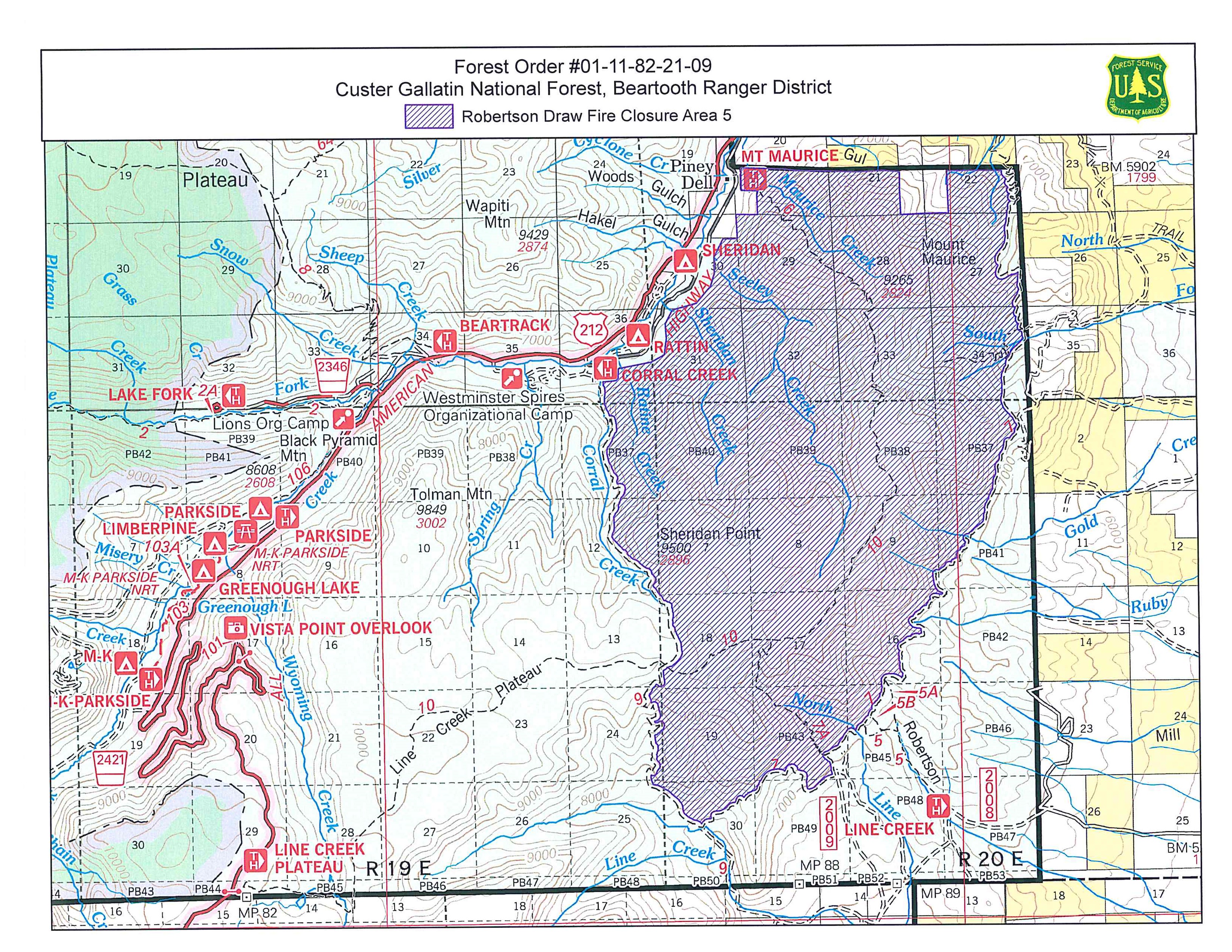
Closures: All National Forest System Lands between National Forest System Trail # 9 (Corral Creek Trail) and National Forest System Trail #7 (Face of the Mountain Trail) are closed to entry. Please see Forest Order #01-11-82-21-09 Area Closure Map 5 here: https://inciweb.nwcg.gov/incident/map/7537/0/121407 for more details.
Primary and Cooperating Agencies: USFS, DNRC, BLM, Carbon County Sheriff’s Office, DES, and Road Department, Red Lodge Fire District, and Belfry Fire District
August 25th Weekly Update
Related Incident:
Publication Type: News
Current Status: Another week of very little activity to report. Smoke has not been observed on the fire in the last 13 days. The area over the Robertson Draw Fire received 1.03 inches of rain from August 15th to August 21st. While the recent rain has improved conditions, we would like to remind the public that the possibility of the fire increasing in activity and spreading beyond its current perimeter is still a reality. Resources remain ready to respond and remain committed to the safety of firefighters and the community.
Meteetsee Trail Road has been reopened to the public. Please use caution on this road, especially after recent rains, and stay alert to changing conditions.
Planned Actions: Fire crews will continuously monitor and patrol the northwest fire perimeter, which has been the most active area in the past month. Weather and Fuel Conditions: Temperatures for the remainder of the week and into the weekend will be in the low to mid 70’s, with a 30-40% chance of thunderstorms in the afternoon.
The 14-day outlook for the area over the fire is forecasted as seasonal temperatures, but a low chance of wetting rain. Closures: All National Forest System Lands between National Forest System Trail # 9 (Corral Creek Trail) and National Forest System Trail #7 (Face of the Mountain Trail) are closed to entry. Primary and Cooperating Agencies: USFS, DNRC, BLM, Carbon County Sheriff’s Office, DES, and Road Department, Red Lodge Fire District, and Belfry Fire District
August 18th Weekly Update
Related Incident:
Publication Type: News
Current Status: Very little activity to report this week on the Robertson Draw Fire, despite several Red Flag Warning days. Cool temperatures and rain Wednesday August 18th and Thursday the 19th will offer respite from the hot and dry conditions we have been experiencing, however long-term forecasts show us returning to this trend. The BLM-Billings Field Office has rescinded their closure order which was described as all lands west of Highway 72, South of Highway 308, and east of US-212 in Carbon County Montana. The public may access these areas again. The Beartooth Ranger District has also rescinded a portion of the closure order. All National Forest System Lands west of Corral Creek Trail (#9) and east and south of Face of the Mountain Trail (#7) have reopened to the public. Lands within these boundaries remain closed. Please refer to Forest Order #01-11-82-21-09 Closure Area 5 Map on Inciweb. Please use caution in these recently reopened areas and stay alert to changing conditions.
Planned Actions: Fire crews will continue to patrol for pockets of heat along the north and west ends of the fire and ensure hose lays, water storage tanks, and pumps are functional should the fire move north.
Weather and Fuel Conditions: Rain and cool temperatures will dominate for the next several days. This weekend is forecasted to return to more seasonal temperatures, with the chance of thunderstorms. Closures: All National Forest System Lands between National Forest System Trail # 9 (Corral Creek Trail) and National Forest System Trail #7 (Face of the Mountain Trail) are closed to entry.
Primary and Cooperating Agencies: USFS, DNRC, BLM, Carbon County Sheriff’s Office, DES, and Road Department, Red Lodge Fire District, and Belfry Fire District
August 17th Robertson Draw Closure Update Order 0111822109
Related Incident:
Publication Type: Closures
Line Creek Plateau Trail ( #7 b ), Corral Creek Trail (#9), Face of the Mountain Trail (#7), and Robertson Draw Trail (#5) have been reopened to the public.
North Line Creek Trail (#7 A) and Mt. Maurice Trail (#6) remain closed.
See corresponding map for additional details.
Air Quality Alert 72921
Related Incident:
Publication Type: Announcement
The Montana Department of Environmental Quality has issued an Air Quality alert for many counties, including Carbon County, due to increasing particulate concentrations from local and regional fires. This alert is in effect until further notice.
As of 3PM posting on 7/29/21, the Red Lodge Monitoring Station is categorized as Moderate. Data is updated hourly and can change throughout the day. To check current air quality conditions, visit https://svc.mt.gov/deq/todaysair/.
Smoke reported 72721
Related Incident:
Publication Type: Announcement
This afternoon, smoke was reported on the north side of Mt. Maurice from the #RobertsonDrawFire. Aerial resources were requested and a Type 3 helicopter has responded with effective water drops onto the area.
We remain committed to keeping firefighters and the community safe. Smoke may be seen on hot, dry days like today. Response will be strategic based on fire behavior, available resources, current and expected weather conditions, location of the activity, and the hazards within that location.
Temporary Flight Restriction Lifted 72721
Related Incident:
Publication Type: Announcement
The Temporary Flight Restriction over the Robertson Draw Fire has been lifted as of 10:00 AM on 7/27/21.
Robertson Draw Fire Fact Sheet 72421
Related Incident:
Publication Type: News
Location: 7 miles south of Red Lodge, Montana
Incident Command: Type 3 Incident Management Team, Shawn Gettings – Incident Commander
Size: 29,885 acres
Containment: 90%
Personnel: 69
Current Status: The Robertson Draw Fire is now at 90% contained and 29,885 acres. The small increase in acreage is due to more accurate field mapping. Incident Command and cooperating agencies have discussed and continue to discuss the long-term management of the Robertson Draw Fire. The portion of the fire burning on the northwest side of Mt. Maurice is in difficult terrain and, in some areas, unsafe for firefighters to construct containment line and mop up hot spots. Firefighters completed containment line in the area on Mt. Maurice that they can safely access. Strategies are in development that reduce firefighter risk and have a high probability of success in protecting private property as well as keeping the fire confined to its current footprint. Existing hand and dozer line will be used in concert with a network of pumps and hose to protect private property and other tactics, including aerial resources, will be used to hold this fire.
Transparency is necessary with the public to convey that there is a possibility of the fire not only picking up in activity, but also spreading past the current fire perimeter if certain variables such as fuel dryness and elevated fire weather were to line up to support fire spread. All measures are being taken to avoid this possibility, but a small portion of the fire perimeter cannot be contained and the warm, dry trend will likely continue for much of the summer. Resources will remain ready at all times with quick response and remain committed to keeping firefighters and the community safe. Because of the inability to mitigate the risk to firefighters on the northwest face of Mt. Maurice, the area will be living with fire until a season-ending rain or snow event takes place.
Planned Actions: Crews made great progress yesterday in completing and inspecting containment line along the western fire perimeter. Today, they will continue working on the shaded fuel break and ensuring sprinkler systems are in place and operational for Structure Protection Plans.
Weather and Fuel Conditions: High pressure over the region will promote warm and dry conditions through the weekend. Relative humidity values will be low in the afternoons with poor recoveries at night. This weekend will be sunny to mostly sunny with some haze and smoke.
Closures: The Custer Gallatin National Forest lands south of Point of Rocks and east of Highway 212 and east of Wyoming Creek are closed with the following exceptions: Sheridan and Rattin Campgrounds, the Westminster Church Camp and the summer residences at Corral Creek and Spring Creek. A Closure Order is in effect on all Bureau of Land Management lands lying West of State Highway 72, South of State Highway 308, and East of US Highway 212 in Carbon County. The North and South Grove Creek Road, Gold Creek Road, Ruby Creek Road, Meeteetse Trail, and Robertson Draw Road to the state line is closed to public use. If you are visiting the area, please check alerts and closures https://www.fs.usda.gov/alerts/custergallatin/alerts-notices.
Temporary Flight Restrictions (TFR): A TFR is currently issued for air space over the Robertson Draw Fire (FDC 1/1687) to provide a safe environment for firefighting aircraft operating in the area. Remember that temporary flight restrictions also apply to unmanned aircraft systems (UAS) or drones. If you fly, we can’t! More information on the TFR can be found here https://tfr.faa.gov/save_pages/detail_1_1687.html.
Primary and Cooperating Agencies: USFS, DNRC, BLM, Carbon County Sheriff’s Office, DES, and Road Department, Red Lodge Fire District, and Belfry Fire District
Robertson Draw Fire Fact Sheet 72321
Related Incident:
Publication Type: News
Location: 7 miles south of Red Lodge, Montana
Incident Command: Type 3 Incident Management Team, Shawn Gettings – Incident Commander
Size: 29,841 acres
Containment: 85%
Personnel: 46
Current Status: Incident Command and cooperating agencies have discussed and continue to discuss the long-term management of the Robertson Draw Fire. The portion of the fire burning on the northwest side of Mt. Maurice is in difficult terrain and, in some areas, unsafe for firefighters to construct containment line and mop up hot spots. Firefighters completed containment line in the area on Mt. Maurice that they can safely access. Strategies are in development that reduce firefighter risk and have a high probability of success in protecting private property as well as keeping the fire confined to its current footprint. Existing hand and dozer line will be used in concert with a network of pumps and hose to protect private property and other tactics, including aerial resources, will be used to hold this fire.
While much of the fire received good rain on July 20th, measuring 0.9 inches on Line Creek Plateau, the Robertson Draw Fire will again pick up in fire activity, as it did recently after several days of hot and dry conditions. Transparency is necessary with the public to convey that there is a possibility of the fire not only picking up in activity, but spreading past the current fire perimeter if certain variables such as fuel dryness and elevated fire weather were to line up to support fire spread. All measures are being taken to avoid this possibility, but a small portion of the fire perimeter cannot be contained and the warm, dry trend will likely continue for much of the summer. Resources will remain ready at all times with quick response and remain committed to keeping firefighters and the community safe. Because of the inability to mitigate the risk to firefighters on the northwest face of Mt. Maurice, the area will be living with fire until a season-ending rain or snow event takes place.
Planned Actions: Crews will be transported by helicopter closer to the northwest portion of the fire where they will inspect the completed containment line and check for heat along the perimeter. Other crews will be establishing a shaded fuel break near structures and ensuring structure protection measures are in place effectively.
Weather and Fuel Conditions: Today will be mostly sunny with no thunderstorms expected. Temperatures will be warmer and drier air will move in for the next couple of days. Winds will increase today and continue into Saturday. Humidity will be 18-24% with poor overnight recoveries the next couple of nights.
Closures: The Custer Gallatin National Forest lands south of Point of Rocks and east of Highway 212 and east of Wyoming Creek are closed with the following exceptions: Sheridan and Rattin Campgrounds, the Westminster Church Camp and the summer residences at Corral Creek and Spring Creek. A Closure Order is in effect on all Bureau of Land Management lands lying West of State Highway 72, South of State Highway 308, and East of US Highway 212 in Carbon County. The North and South Grove Creek Road, Gold Creek Road, Ruby Creek Road, Meeteetse Trail, and Robertson Draw Road to the state line is closed to public use. If you are visiting the area, please check alerts and closures https://www.fs.usda.gov/alerts/custergallatin/alerts-notices.
Temporary Flight Restrictions (TFR): A TFR is currently issued for air space over the Robertson Draw Fire (FDC 1/1687) to provide a safe environment for firefighting aircraft operating in the area. Remember that temporary flight restrictions also apply to unmanned aircraft systems (UAS) or drones. If you fly, we can’t! More information on the TFR can be found here https://tfr.faa.gov/save_pages/detail_1_1687.html.
Primary and Cooperating Agencies: USFS, DNRC, BLM, Carbon County Sheriff’s Office, DES, and Road Department, Red Lodge Fire District, and Belfry Fire District
Evacuation Warning Lifted 72121
Related Incident:
Publication Type: Announcement
The evacuation warning issued on 7/19/21 by Carbon County Sheriff’s Office has been lifted. Residents should continue to stay updated and aware of the fire situation.